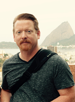
Welcome to Spatial Data Science for Emergency Management (GEOG 858)!

R. Matthew Beaty, Ph.D - "Matt"
Availability: Course email through Canvas is always the best way to get in touch with me. If urgent, it is also OK to SMS/iMessage. We can make an appointment via Zoom (via Canvas) if we need to talk. Note that I am located in Australia so there may be a considerable time difference from where you are (you can check my local time here).
About Me:
Hi! I’m Matt Beaty, your instructor this term for Spatial Data Science for Emergency Management.
In addition to teaching for Penn State’s Online Geospatial Education Program, I work for the Australian Bureau of Statistics (ABS) after short secondment to the Bureau of Meteorology (BOM). My focus at both agencies has been on disaster preparedness, response, and recovery. Prior to this, I worked for the Australian Government Department of Health (DOH) in the Health Analytics Branch, and this included work on the COVID-19 response through developing analysis and maps for decision-makers. Before joining the Department of Health, I was a Senior Experimental Scientist in the Cities Program and Climate Adaptation Flagship at the Commonwealth Scientific and Industrial Research Organisation (CSIRO), Australia’s national research organization. Before that, I did my Ph.D. work in Geography at Penn State!
My current work focuses on using geospatial analysis to better understand relationships between the built environment, vulnerable populations, and climate-related hazards such as heatwaves, floods, and bushfires. This research focuses on current conditions and future conditions expected under different climate change scenarios. I am also interested in how geospatial data and analysis can identify mitigation and adaptation opportunities through a range of social, engineering, and environmental interventions. I’ve also undertaken projects on fire ecology, green infrastructure, transportation logistics, and urban planning. It’s probably clear that my work involves the linkage and integration of a wide range of data types, methods, and disciplines, and has also involved working with some great teams!
Some of my current work includes:
At the ABS/BOM, I am working on a new initiative, the Australian Climate Service (ACS; www.acs.gov.au). This effort is aimed at developing (spatial) data products and services to support government agencies tasked with emergency management. The Black Summer bush fires of 2019-20 served as the motivation for the new agency, but it considers a range of other disasters e.g..., floods, cyclones, heatwaves.
I also just completed a project called Reducing Illness and Lives Lost from Heatwaves. This work uses big 'linked' data to understand mortality and morbidity related to extreme heat in Australia. We will talk about linked data and social vulnerability mapping later in this course.
My team at the Department of Health worked on the COVID-19 response by providing analysis and mapping products that have been used to inform the national response and specific lockdown measures for the city I live in, Melbourne. It has been a very busy time for emergency response, and the role of spatial data science has never been more important.
As mentioned, I live in Melbourne, Australia, and moved here almost 20 years ago with my partner, who is also a geographer, and we have a crazy stupid boxer dog named Oscar. I like to travel as often as I can and have been every continent including Antarctica that I visited in late 2022. In my free time, I like to go bush walking (and city walking), explore the region, and take photos.
I'm excited to work with you this term and will work very hard to make sure this class works well for you. Please let me know what works well and what does not - as I am very eager to have your feedback.
Cheers,
Matt
I'm Dr. Matt Beatty. You may see me listed as Robert in some of the program information, but I go by my middle name, which is Matt. I'm passionate about using geospatial data and techniques to understand the impacts of crises and natural disasters on people and their communities. This includes understanding what makes places vulnerable, but it also includes what makes places resilient. That is, their ability to cope with, and bounce back from, extreme events. And we could be talking about fires, floods, civil unrest, and even pandemics. Taking a spatial view also allows us to identify opportunities for improving resilience and this could happen on multiple fronts, from social, economic, or environmental resilience. But ultimately, it's about reducing the risks of negative outcomes. These are themes I pursue in my teaching and
I'd like to emphasize to both the students and my colleagues that geospatial analysis can help you both understand complex problems but also it can help you identify solutions and place is often the common denominator when integrating across a wide range of topics. On a more personal note, I live and work in beautiful Melbourne, Australia. Melbourne is often at the top, or near the top, of lists of cities that are the most livable in the world and I tend to agree! Melbourne's great! Well, I hope to see you in class in the near future. Thank you.