Coastal Processes, Hazards, and Society

Barrier Islands

PrintPrint

Barrier Islands

How is a barrier island defined? What marine process is primarily responsible for the alignment of sand that is required to maintain a barrier island? How does hydrodynamic regime affect barrier morphology?

Barrier islands are shore-parallel elongated accumulations of sand that are constructed by waves and build vertically by the accumulation of sand from wind transport. They can be found along approximately 15% of the world’s existing coastlines, with the majority of them located along trailing edge or marginal sea coasts with wide, low gradient continental shelves. In some locations, they are isolated and separated from the mainland by either open bodies of water or marsh and tidal creek systems, depending upon the hydrodynamic regime of the area. However, in some locations, they can be attached to the mainland at one end (barrier spit) or at both ends (welded barrier). The length of barrier islands can range from just a few kilometers to as much as 100 km, and they can be as much as several kilometers wide.

See caption.
Satellite image of the Outer Banks, an approximately 300 km long string of barrier islands off the coast of North Carolina, U.S. The barrier islands are separated from the mainland by a series of relatively shallow water sounds. Notice how the ends of the entire barrier chain come closer to the mainland, thus reducing the size of the backbarrier open water area.
Credit: NASA
See caption.
Aerial view of Long beach barrier island, New York, U.S. Notice the separation of the barrier island from the mainland by a backbarrier marsh and bay environment. Also, notice the inlet to the backbarrier along the left side of the image.
Credit: Atlantic Beach and Long Beach Aeriel View by Jorfer via Wikimedia Commons (Public Domain)

Primary Morphological Components

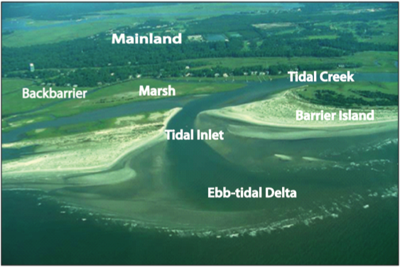
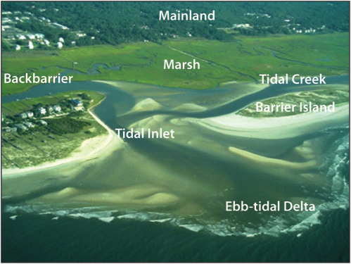
The primary components of a barrier island system include the following

  1. Nearshore, beach and dune systems: these environments share the same characteristics as those that were discussed in the section for beaches.
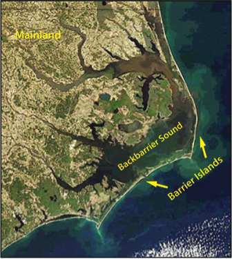
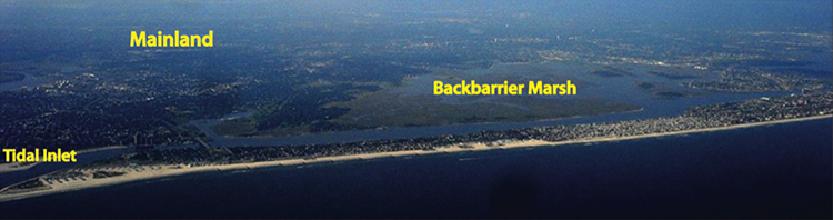
  2. Backbarrier: the area located between the barrier and mainland and can consist of bodies of water such as bays, lagoons, and sounds, as well as marshes, tidal creeks, and tidal flats.
  3. Bays and Lagoons: shallow open to partially restricted water areas located in the backbarrier.
  4. Marshes: salt-tolerant vegetated areas within the intertidal area of the backbarrier.
  5. Tidal Flats- flat, sandy to muddy areas that are exposed at mid to low tide along the backbarrier.
  6. Tidal creek: a backbarrier creek through which water flows during flood and ebb tide.
  7. Tidal Inlets: openings along a shore-parallel chain of barrier islands through which water is exchanged between the open ocean and the backbarrier environments during a tidal cycle.
  8. Tidal Deltas: sandy to silt rich shoals that rise above the adjacent seafloor and are located on the landward and seaward side of tidal inlets.
See caption.
Oblique aerial image of a barrier island with labeled components. Note the clearly defined ebb-tidal delta where the waves are breaking in the foreground, as well as the deeper tidal channel that connects the backbarrier to the open ocean and delivers sediment in this setting to the ebb-tidal delta. Also, notice how the inlet is constricted where sediment is accumulating at the end of the barrier island on the right-hand side, the result of longshore transport into that area, and nearshore sandbars migrating on to the beach face.
Credit: D. FitzGerald
See caption.
View of a tidal inlet system along the southern North Carolina coast. Note the well-developed ebb-tidal delta and the numerous submerged sand deposits on the ebb delta, which will eventually attach to the adjacent beaches in this sediment-rich regime. Notice that the right-hand side of the tidal inlet (looking toward the mainland) contains a platform of sand that is locally infilling the inlet. The infilling of sediment on this side of the inlet along with the curved, linear fabric of the barrier island just to the right of the inlet suggests that the dominant longshore transport of sediment into the inlet is from the right. This type of morphology suggests that the barrier is advancing into the inlet area through the accumulation of longshore transported sediment.
Credit: D. FitzGerald