
Houston, Harvey, and Flood Policy
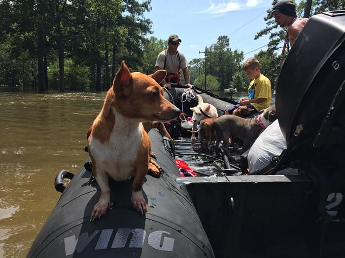
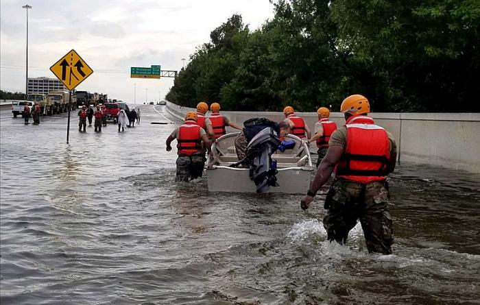
Houston’s topography and geography make it a very flood-prone city, as much of it sits in a sprawling floodplain. A glance at a map of Houston reveals a network of waterways – bayous - connected to the tidal water of Trinity and Galveston Bays. As the Washington Post video linked below explains, Houston is more at risk for rainfall and runoff flooding than storm surge flooding from the Gulf of Mexico, although the latter is not out of the question. The other factor that makes Houston vulnerable to flooding is its urban sprawl. The Houston Metropolitan area has more than 6 million residents, and its population is increasing. It has seen a six-fold increase in population since 1960. The lack of comprehensive planning and zoning during those decades has led to a loss of natural, permeable surfaces and a growing propensity for flooded neighborhoods. As the video mentions, the bayous can serve to conduct water away from built areas and help reduce flooding, but they can also back up and overflow when a storm like Harvey occurs. Hurricane Harvey hit the eastern Texas Gulf coast as a category 4 storm, devastating coastal communities such as Rockport, to the west of Galveston. However, the storm is much better known for the rainfall it dumped on the greater Houston area and southwestern Louisiana. Many communities, including Houston, received more than 40 inches of rain in four days (isolated locations received over 60 inches) and the damages amounted to $125 billion. Many lives were lost in the flooding, which displaced 30,000 people, flooded hundreds of thousands of homes, and closed Interstate 10, which is the main route for commerce across the southern United States.
Please watch the Washington Post video, Here's why Houston is flooding so badly (3:19)
Houston has experienced three “500-year floods” between 2015 and 2017. A 500-year flood is NOT a flood that is expected to occur every 500 years, in spite of its misleading name. It is, in fact, a flood that has a one in 500 or 0.2% chance of occurring in any particular year. So, it is possible to experience a flood of this magnitude two years in a row. However, these types of floods have been occurring more frequently along the Gulf Coast in the past decade.
Prior to Harvey, Houston’s building codes required new construction and renovated buildings to be elevated above the “100-year” floodplain” – or the areas susceptible to floods that have a 1% chance of occurring in any given year (or 100-year floods).
After Harvey, the city of Houston and surrounding Harris County enacted new ordinances under which any building under construction or re-construction, must be raised two feet above the 500-year flood plain. This is an expensive undertaking, but the city and county leaders are taking a proactive approach in putting an improved policy in place that will avoid putting people and their property back in harm’s way after each flood. The Mayor of Houston, Sylvester Turner, notes that although some oppose the new rules due to the increased costs of construction, it is essential to the future prosperity of the city and will save lives. According to the FEMA website, many homes that flooded in Harvey met the minimum FEMA requirements and were not required to have flood insurance, but a Houston Public Works study shows that if the new rules had been in place at the time, 84% of the homes that were flooded by Harvey’s rainfall would have been covered.
The new rule is explained in the ABC News video Houston's New Building Codes.
If we look at the City of Houston’s Hurricane Harvey Recovery: A Progress Report (January 2019), it is clear that the plan includes policy and legislation addressing mitigation and resilience so that going forward, disasters like the flooding following Harvey are not repeated. These planning documents offer a valuable guide for other cities facing recovery.
Homeowners can apply for rebuilding assistance from the city of Houston’s Harvey Homeowner Assistance Program. Other forms of assistance can be found through organizations such as the non-profit Saint Bernard Project. This organization began after Hurricane Katrina in St. Bernard Parish, LA, and grew to work in many other places. SBP'S Hurricane Harvey Recovery details work done after Hurricane Harvey to help homeowners recover. It includes a video that emphasizes the importance of partnerships with AmeriCorps and corporate partners such as Toyota to help people rebuild after a disaster.
Harrison County residents (including the city of Houston) have access to a valuable interactive mapping tool for determining the flood potential for a neighborhood: Harris County Flood Education Mapping Tool The map provides color-coded spatial information based on the 1% and 0.2% flood zones.