Barrier Islands
Barrier Islands
How is a barrier island defined? What marine process is primarily responsible for the alignment of sand that is required to maintain a barrier island? How does hydrodynamic regime affect barrier morphology?
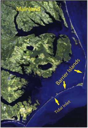
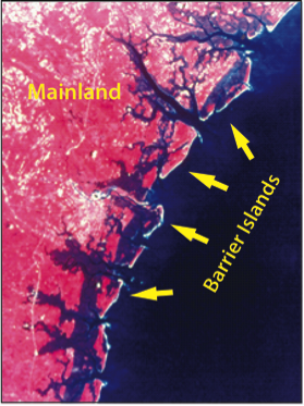
Barrier islands are shore-parallel elongated accumulations of sand that are constructed by waves and build vertically by the accumulation of sand from wind transport. They can be found along approximately 15% of the world’s existing coastlines, with the majority of them located along trailing edge or marginal sea coasts with wide, low gradient continental shelves. In some locations, they are isolated and separated from the mainland by either open bodies of water or marsh and tidal creek systems, depending upon the hydrodynamic regime of the area. However, in some locations, they can be attached to the mainland at one end (barrier spit) or at both ends (welded barrier). The length of barrier islands can range from just a few kilometers to as much as 100 km, and they can be as much as several kilometers wide.
Primary Morphological Components
The primary components of a barrier island system include the following
- Nearshore, beach and dune systems: these environments share the same characteristics as those that were discussed in the section for beaches.
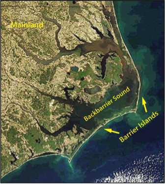
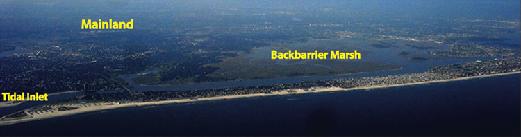
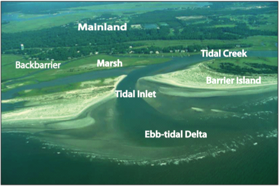
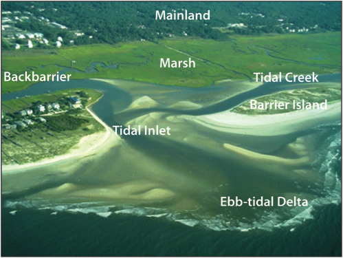
- Backbarrier: the area located between the barrier and mainland and can consist of bodies of water such as bays, lagoons, and sounds, as well as marshes, tidal creeks, and tidal flats.
- Bays and Lagoons: shallow open to partially restricted water areas located in the backbarrier.
- Marshes: salt-tolerant vegetated areas within the intertidal area of the backbarrier.
- Tidal Flats- flat, sandy to muddy areas that are exposed at mid to low tide along the backbarrier.
- Tidal creek: a backbarrier creek through which water flows during flood and ebb tide.
- Tidal Inlets: openings along a shore-parallel chain of barrier islands through which water is exchanged between the open ocean and the backbarrier environments during a tidal cycle.
- Tidal Deltas: sandy to silt rich shoals that rise above the adjacent seafloor and are located on the landward and seaward side of tidal inlets.
Hydrodynamic Regime
Hydrodynamic Regime
Because barrier islands are built by waves, they do not develop in tide-dominated environments. Waves are responsible for the longshore transport of sediment, and it is this transport that drives the deposition of sediment to create elongated features consisting of sandy barrier islands. There are, however, numerous examples of barrier islands within mixed-energy as well as wave-dominated environments. In fact, the two fundamental types of barrier islands are recognized as wave-dominated and mixed-energy barriers.
Wave-Dominated Barriers
Wave-Dominated Barriers
Wave-dominated barrier islands are long, narrow barrier islands with typically widely spaced tidal inlets. Because of the wave dominance, the capability for longshore transport is high, and tidal inlets in this type of system are relatively narrow because longshore transported sediment acts to fill in the inlets and restrict their widths. The tidal deltas on the seaward side of the inlets, ebb-tidal deltas, also tend to be small compared to mixed energy barrier systems because waves tend to limit the distance that ebb-tidal deltas can migrate seaward.
Mixed-Energy Barriers
Mixed-Energy Barriers
Mixed-energy barrier island systems are typically short and wider at one end than the other end. Historically, this type of morphology has been referred to as a drumstick barrier island because of its approximate similarity in shape to the drumstick of a chicken leg. The tidal inlets between these barriers are large because of the relatively higher tidal energy. Compared to wave-dominated barriers, they also have large ebb-tidal deltas because the strength of the tidal currents is able to transport sediment seaward in a regime of relatively low wave energy. The relatively wider end of the island is the result of the accretion of sediment as waves refract around the edge of the ebb-tidal delta, causing a localized reversal in the longshore transport pattern and leading to sand accumulation.
Future of Barrier Islands
Future of Barrier Islands
In recent years, there have been numerous studies investigating how barrier island systems respond to change in sea level and impacts created by storms as they erode sediment and destroy coastal property. Because barrier islands form a true barrier along many inhabited coastal zones, they represent a line of defense for inland communities from the destructive power of storm surges and waves that are driven by large storms. Unfortunately, however, there are global trends in barrier size reduction because of reduced sediment input caused by damming rivers, human modifications to coastal systems, storm-driven erosion, and relative sea level rise.
In future modules, we will explore the dilemmas facing communities located on barrier islands and the question of whether these communities can expect to survive.
Check out these links to explore barrier islands further:
Louisiana's barrier islands: Barataria-Terrebonne National Estuary Program: Barrier Islands [2]
Video and article on restoring Louisiana's barrier islands: Restoring Louisiana's Barrier Islands [3]
Learning Check Point
Learning Check Point
Please take a few minutes to think about what you just learned, then consider how you would answer the questions on the cards below. Click "Turn" to see the correct answer on the reverse side of each card.