Deltaic Coasts
Deltaic Coasts
What is a delta? How does the morphology of a delta reflect the processes acting to shape it? Why are deltas at risk?
Geologic and archeological evidence clearly indicates that a significant part of the rise of modern societies and culture can be attributed to the development of the modern world's deltas, which started forming during the slowed post-ice age sea level rise. Numerous lines of evidence indicate that well-developed societies were occupying deltas in the time frame of 4,000 to 7,000 years before present because of the many natural resources that deltaic environments generally contain. Resources such as shellfish, fish, furs, and plants were necessarily taken from the wild by our ancestors, and so many ancient societies began proximal to deltaic environments.
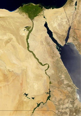
The term delta comes from Herodotus, a Greek historian, and philosopher who recognized the similarity of the upside-down Greek letter delta (Δ) and the shape of the Nile river delta when viewed from the south toward the north.
What is a delta?
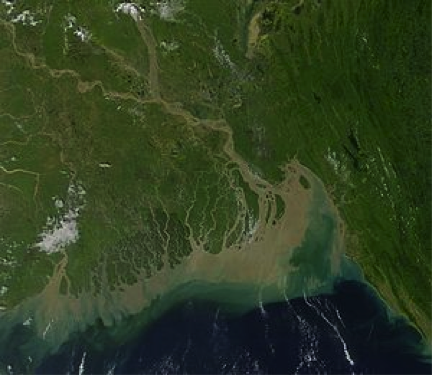
A delta is a subaerial and subaqueous volume of sediment that has accumulated at the mouth of a river as it enters into an open body of water. The largest deltas are the product of very large river systems that are transporting large quantities of sediment. The Ganges-Brahmaputra delta is one of the largest deltaic environments on the planet and carries vast amounts of sediment to the ocean. There, the sediment is reworked by strong tidal currents of the region to form inlets and sediment ridges.
Delta Morphologies and Driving Processes
Delta Morphologies and Driving Processes
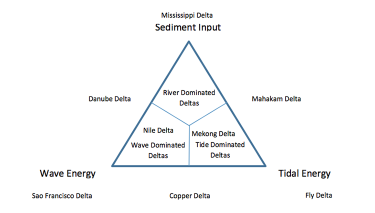
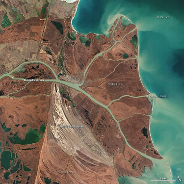
Variations in delta morphology tell us something about the processes that cause and drive the evolution of deltaic environments. Globally, it is widely accepted that there are three end-member morphologies of deltas that reflect the relative influence of wave energy and tidal energy in the receiving basin or sediment input by the source river into the receiving basin. On a ternary plot, these three end members each represent one apex of the plot, and all deltas fall somewhere on this plot. Deltas that are primarily the result of high rates of sediment input tend to be elongated because of their rapid outbuilding associated with high rates of deposition into the receiving basin. Wave-influenced deltas have smooth, often arcuate shorelines with numerous ridges that reflect the longshore transport of river-delivered sediment by the high wave energy. Tidally influenced deltas have numerous shoreline perpendicular tidal passes and tributaries, with sediment bodies aligned parallel to the direction of tidal exchange.
Deltas in Crisis
Deltas in Crisis
During the last decade, a substantial amount of concern has arisen regarding the health of the planet's major deltas. Over-exploitation of deltaic resources by humans, the introduction of pollutants, and excess nutrients to the rivers, as well as the management of river water that feeds deltas has severely damaged the sensitive environments of many deltas. Additionally, reduced sediment loads in many deltas, because of the construction of dams, coupled with global sea level rise and/or local land subsidence has resulted in widespread loss of deltaic wetlands and fronting sandy barrier shorelines. Because deltaic plains are so heavily relied upon by humans and, in some cases, are densely inhabited by humans, there are, for some deltas, widespread efforts to try to halt coastal erosion and environmental damages.
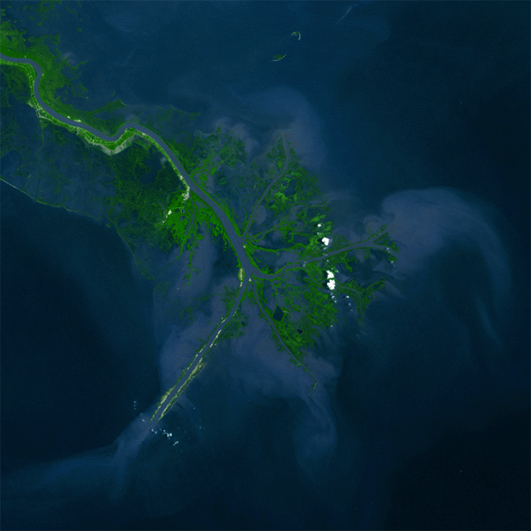
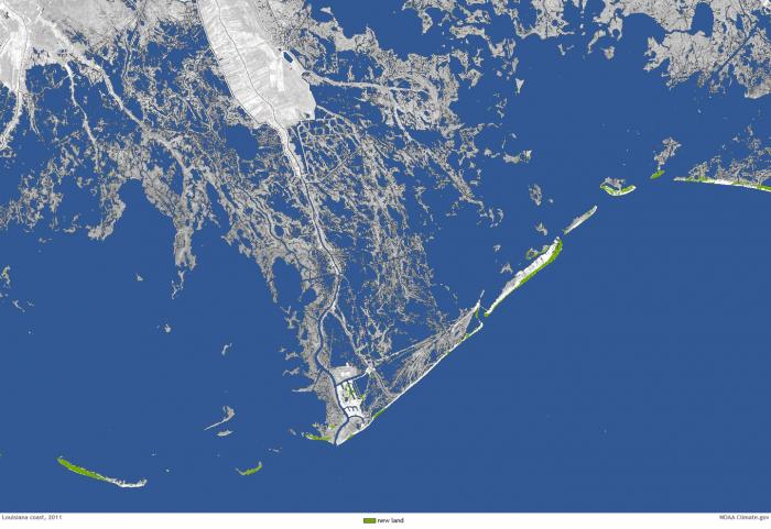
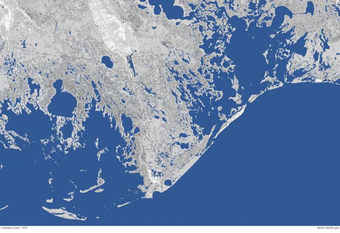
For example, the wetlands of the Mississippi River delta have undergone substantial change during the last century, with large areas of wetlands converted to open water because of relative sea level rise and erosion by storms. The rate is just staggering, with a football field of wetlands vanishing into open water every 30 minutes! The loss of wetlands across the delta is so severe that communities and infrastructure that were once separated from the open Gulf of Mexico by wetlands are now exposed to open marine water and have become more vulnerable to the damaging effects of storm surge. As a result, the state of Louisiana has developed a series of plans to build new land and infrastructure that would help reduce the net loss of land. The staggering change between 1932 and 2011 can be seen in the two satellite images below.
More Information
- For more information on deltas, see Delta [3].
- For more information on issues with and plans to restore the Mississippi River Delta in Louisiana, see Restore the Mississippi River Delta [4].
Learning Check Point
Learning Check Point
Please take a few minutes to think about what you just learned then answer the questions below.