Causes of Sea Level Fluctuations Through Time
Causes of Sea Level Fluctuations Through Time
What were the causes of the changes in sea levels on the Earth over time? There are multiple causes that can be divided into two groups: intrinsic, or internal drivers, originating within the Earth’s system, and extrinsic drivers, which originate outside the Earth’s system. Some of these operate over the timeframe of the Earth’s history, and others operate over shorter timeframes. Some influences are global in scale, while others are more regional or localized. The following pages are part of a partial list of these influences. These drivers are also interconnected, with one influencing another in many cases.
Intrinsic Causes of Sea Level Change
Intrinsic Causes of Sea Level Change
The Earth is a dynamic, self-regulating system, and forever changing. The changes that take place in each of the spheres of the Earth impact the other, connected spheres. There are complex feedback mechanisms that work to maintain the balanced functions of the planet. As we explore the topic of sea level change, the importance of these feedback mechanisms become clear. It is hard to isolate a single cause of sea level rise or fall, as all are connected and may be occurring simultaneously. It is worth remembering some principles you may have learned in your pre-college days, such as the water cycle, rock cycle, plate tectonics, and how heating and cooling affect matter.
Global or eustatic sea level can oscillate due to changes in the volume of water present within the ocean basins relative to storage of that water on land. Short-term sea level change can be driven by sudden tectonic events (e.g., earthquake-induced subsidence/uplift), and tidal processes, but sea level change on the scale of decades to 1000s of years is primarily driven by changes in the Earth's climate system that can be influenced by both intrinsic and extrinsic phenomena.
The Water Cycle
The Water Cycle
As you probably know, the water on the planet is constantly being cycled through various states, such as water vapor in the atmosphere, liquid water in oceans, rivers, and groundwater, and ice in ice sheets and glaciers. This cycling happens at different rates, from rapidly (measured in days) to very slowly (measured in thousands of years or more).
Whether due to climate factors, or plate tectonic factors, water evaporated from the oceans can become locked up on land and prevented from cycling back to the ocean. The USGS estimates that some 8,500,000 cubic miles of water is trapped on land either as ice or as freshwater. When and if this water makes its way back to the ocean (and if it is not replaced on land), sea levels can rise significantly. The Greenland Ice sheet, if melted, is estimated by Byrd Polar Research Center and other scientists to produce a rise of between 6 and 7.4 meters to global sea level if it is not restored on land.
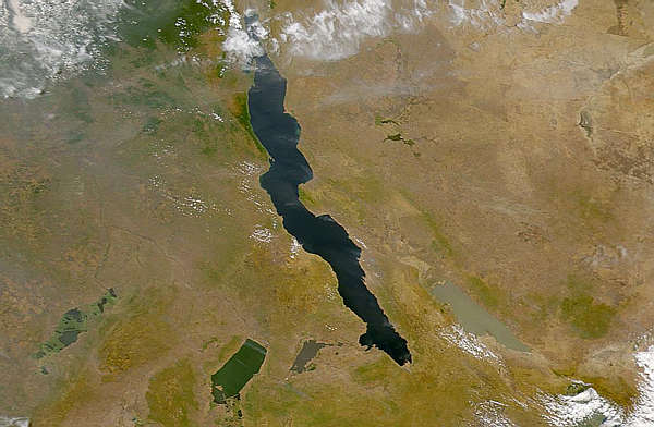
Rift lakes or large intra-continental seaways can trap liquid water that is temporarily removed from the global ocean (an excellent example is Lake Bonneville - the ancestral Great Salt Lake of the western U.S.). If precipitation of ocean-derived water is high on land, and this water is not able to return to the ocean, ocean water levels can drop over time.
Continental aquifers will often hold volumes of water in the subsurface. As these aquifers are de-watered (pumped), the water is released back into the hydrologic system and can be returned to the ocean. Some areas in large desert regions (e.g., in Arizona, Nevada, California, etc.) have withdrawn substantial amounts of water from aquifers. This water is not replaced, ground subsidence occurs, and the aquifer becomes compacted. The withdrawn water is eventually lost to evaporation and ends up back in the ocean.
Glaciers also trap and hold water in solid form. When ocean-derived moisture freezes and is held on land from year to year, they stockpile large volumes of water, and ocean levels can drop.
Two main types of glaciers include alpine and continental glaciers.
- Continental glaciers or ice sheets similar to those on Greenland, Iceland, or Antarctica have been more widespread at times in Earth's history and trapped large volumes of water on land, so much so that continental areas subsided under the great thicknesses of ice built on top of them.
- Large numbers of alpine glaciers at high altitudes (e.g., Andes, Alps, Himalaya, Cascades, Rockies, etc.) collectively contain significant volumes of water that can also be released back to the global ocean if melted.
Isostatic Changes – Glacial Isostatic Adjustment
Isostatic Changes – Glacial Isostatic Adjustment
To understand isostatic changes, you need to consider the fact that huge amounts of water can be stored as ice during colder periods in Earth’s history (many times more than today). When the planet warms and ice melts, this water is returned to the ocean basins (causing a rise in sea level). When ice sheets and glaciers covered the land during the ice ages of the Pleistocene, the weight of the ice depressed the elevation of the land. Over the 20,000 years since the last glacial maximum, the land masses, relieved of their burden of ice, have gradually rebounded. This rebound is called Glacial Isostatic Adjustment or GIA. The level of the land relative to the sea level increases. This can cause a regional sea level change effect and is still impacting parts of Alaska and other northern coasts. These are the emergent coasts we met in Module 2.
This short, but silent video animation illustrates how changes in sea and land level take place in response to the onset and departure of glacial conditions, and the melting of polar ice as the planet warms. It also documents the erosion of sediment from the land and deposition in the ocean basin at each sea level stand. This erosion leaves a signature of each sea level (the erosional notch shown), which is evidence of these changes.
Video: From Glaciation to Global Warming - A Story of Sea Level Change (1:40)
Sea level changes over time. Video shows how water level changes compare to land.
Before the last ice age (more than 30,000 years ago): erosion notch one forms.
During the last ice age: sea level drops, ice forms on land. The Ice is 1 mile thick and erosion notch 2 forms below notch 1 and a new sediment layer forms.
The weight of the ice pushes down on the land: forming erosion notch 3 between notch 1 and 2 and a new sediment layer forms.
As the ice melts: the sea level rises forming erosion notch 4 above notch 1 and a new sediment layer forms.
With no ice to hold it down, the land begins to rise again (rebound)…and it’s still rising very slowly: Erosion notch 5 forms between notch 1 and 4 and a new sediment layer forms.
Polar ice caps melt: sea level rises as a result of melting ice. Erosion notch six forms above all other notches. New sediment layer forms.
Albedo Feedback Mechanism
Albedo is a measure of the reflectivity of the Earth's surface. Ice-albedo feedback is a strong positive feedback in the climate system. Warmer temperatures melt persistent ice masses in high elevations and upper latitudes. Ice reflects some of the solar energy back to space because it is highly reflective. If an equivalent area of ice is replaced by water or land, the lower albedo value reflects less and absorbs more energy, resulting in a warmer Earth. This effect is currently taking place - for example, as the Greenland ice sheet melts there is less bright white, reflective ice and more, darker less reflective water and land surfaces. This decreases the albedo effect and increases warming. Conversely, cooling tends to increase ice cover and hence the albedo, reducing the amount of solar energy absorbed and leading to more cooling.
Thermosteric Sea Level Change - Thermal Expansion and Sea Level Rise
Thermosteric Sea Level Change - Thermal Expansion and Sea Level Rise
Another substantial mechanism for changing sea level is related to thermal expansion/contraction properties of water molecules themselves. In our high school science classes, we all learned that as the temperature of different substances increases, the molecules within those substances become more "excited". These excited molecules that bump into each other more frequently take up more space, so the warmer substance will expand in volume and will have a lower density. The behavior of water molecules follows this same pattern. When liquid saltwater warms up, its density (mass per unit volume) decreases as the volume increases. As temperatures of the ocean increases, the volume of seawater increases and can produce a higher sea level. Conversely, as seawater cools down, the density increases as the volume decreases. This produces lower sea levels.
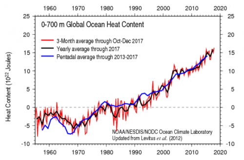
Geoscientists and physical oceanographers are developing mathematical models to explain and predict the impact of even small changes in ocean temperature on sea level. In the image above, you will notice that different ocean layers contribute to rise at different rates. Some scientists believe that the deep ocean layers, as thick and deep as they are, will volumetrically produce even higher sea levels if they warm in the absence of polar glaciers. Better empirical modeling will continue to be refined so that we will have a better sense of the impact that this phenomenon has on overall sea level change.
Seemingly small temperature changes (even as small as 0.1 degrees Celsius), when extrapolated over the entire globe, can produce a significant sea level rise effect when considered over time. On an annual basis, the impact might not seem like a lot (just a few mm./yr. on average), but over a decade or two, this adds up to a substantial change. As such, most scientists believe that recent sea level change may be strongly tied to increased warming of the atmosphere, which in turn warms the ocean. Given this fact, many scientists are alarmed by the additive impact of melting of glaciers, which ultimately act as the cooling mechanism for the deep sea. If glaciers are not present, the ocean's ability to overturn will be impaired and, it is argued, this can cause more rapid hyper-warming of the ocean's waters leading to even higher sea levels. This is an example of a positive feedback mechanism.
Plate Tectonics and Sea Level Change
Plate Tectonics and Sea Level Change
Today, the Earth’s ocean is made up of the large Pacific, Atlantic, Indian, and Arctic Oceans. These bodies of water were not always in their current shape and configuration. As a result, you can imagine the large-scale changes in sea level that would have accompanied their assembly since the last super-continent (Pangea) began to break up some 250 million years ago. These changes would have been very slow but significant, operating on time scales beyond those experienced by human beings.
Long-Term Sea Level Change (hundreds of thousands to millions of years) is influenced by factors that modify the size and shape of ocean basins. Global or eustatic sea level can change as the result of changes in the number, size, and shape of ocean basins. Throughout Earth's history, the global ocean has been modified by plate tectonics. Often, large continents assembled from smaller ones produced more expansive oceans between them. These expansive ocean bodies were subsequently dissected when super-continents rifted and formed smaller oceans out of the formerly vast oceans. For visualization purposes, please watch the quick paleogeographic animation below.
Video: Earth 100 Million Years From Now (3:18) No Audio.
The tectonic processes at work on the Earth influence the size of ocean basins and, therefore, sea level in many, complex ways. The following list gives an idea of some of these processes and their interactions and feedback mechanisms:
- rifting of tectonic plates at divergent plate boundaries;
- assembly of micro-continents, volcanic terrains, continents - especially supercontinents like Rodinia, Pangea, etc.;
- subduction of tectonic plates at ocean trenches at convergent plate boundaries;
- eruption and formation of large igneous provinces that originate from massive extrusions of lava, oceanic plateaus, hotspot volcanic island chains, etc.;
- high rates of volcanism on the seafloor volumetrically displace water out of the ocean basin, producing higher sea levels (called transgression of sea level);
- low rates of volcanism allow water to return to the ocean basin and sea levels drop (called regression of sea level);
- when rocks cool from a molten state, they contract in volume; this allows subsidence to occur, especially along the mid-ocean ridges, and sea levels fall;
- when rates of volcanism are low, rocks tend to cool faster and sea levels drop as subsidence occurs.
- conversely, when rates of volcanism are high, it takes longer for the rocks to cool, and sea level remains higher for longer periods of time after the rate of volcanism subsides.
For more information
Take a look at There Are Four Main Causes of Sea Level Rise [8]. Here is more explanation of this concept. [9]
Atmospheric Changes
Atmospheric Changes
We have already considered the influence of changes in the composition of the Earth’s atmosphere, specifically the carbon dioxide and oxygen levels, as drivers for fluctuations in atmospheric temperatures, which can, in turn, influence the temperature and level of the ocean. The anthropogenically driven increase in CO2 and other greenhouse gases in the atmosphere explains the current rapid warming of the Earth’s atmosphere (more on this later). The concept of the greenhouse effect and “greenhouse gases” has been widely discussed, but bears a reminder here, so we can connect these changes with those that have taken place through the history of the planet. Of course, there are many other drivers for changes in the chemical composition of the atmosphere, including rates of volcanic activity.
Extrinsic Drivers of Sea Level Change
Extrinsic Drivers of Sea Level Change
Earth Orbit, Solar Insolation Variability & Sea Level Change
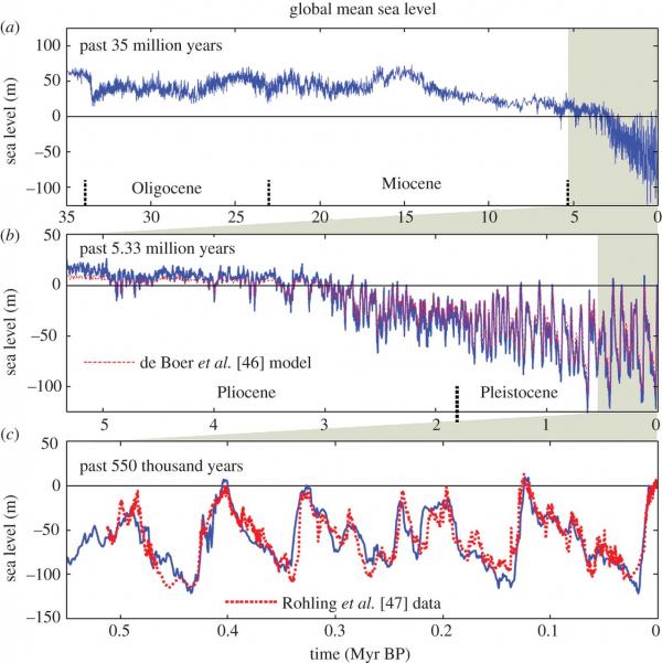
Take look at the graphs showing changes in sea level through the history of the Earth. The top figure covers 35 million years, the middle one covers a little more than 5 million years, and the bottom one zooms in to the past 500,000 years. What do you notice? Is there a regularity in the pattern of sea level ups and downs?
Through Earth’s history, there appears to have been a regular spacing of glacial maximum events, at roughly 120 thousand years (ky). When variations in Earth's orbit produce repetitive changes in climate and sea level, the observed cycles are often referred to as Milankovitch Cycles. Many sedimentary rock sequences have been shown to have stacking patterns that reflect these time scales, as do ice core data.
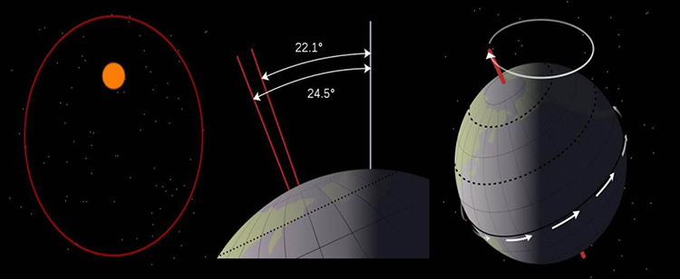
Milankovitch Cycles
Mathematician Milutin Milankovitch proposed an explanation for the changes in the way the Earth orbits the sun. These changes define the sequence of ice ages and warm periods.
- The Earth’s orbit changes from being nearly circular to slightly elliptical (eccentricity). This cycle is affected by other planets in the solar system and has a period of around 100,000 years.
- The angle of tilt of the Earth’s axis changes from 22.1° to 24.5° (obliquity). This cycle has a period of 41,000 years.
- The direction of the tilt of the axis changes (precession) on a cycle of 26,000 years.
- These changes influence the length of the seasons and the amount of solar radiation received by the Earth.
Optional Video
Please watch Milankovitch Cycles in 5 Minutes [12] (5:00), if you are not already familiar.
Click for the "Milankovitch Cycles in 5 Minutes" video transcript.
The Sun is the Earth's main energy source. In fact, it provides 99.96 percent of all the energy that drives the Earth's climate. Some of the energy produced by nuclear fusion in the sun's interior will eventually strike the top of the Earth's atmosphere. The amount of energy that does strike the atmosphere depends on two main factors: the total amount of energy produced and transmitted by the Sun, and the orbital cycles of the Earth with respect to the Sun. The energy transmitted by the Sun is in a constant state of flux depending on solar activities such as sunspots, solar flares, coronal loops, and coronal mass ejections. The relationship between the Earth's orbital cycles and climate change was proposed by Milutin Milankovitch. Milankovitch was a Serbian engineer, and during the 1930s, he proposed that the changes in the intensity of solar irradiation received on the Earth were affected by three fundamental factors: precession, obliquity, and eccentricity. These factors are now collectively known as the Milankovitch cycles. The Milankovitch cycles are widely accepted by climate change scientists and are well documented by, for example, the IPCC. A more detailed description of the cycles is available by clicking on the tab above, but the remainder of this video will provide an excellent overview. The Earth rotates on its axis every 24 hours. Around once in 27 days, the Sun also rotates on its axis. Its average distance from the Earth is approximately 150 million kilometers (93 million miles). It is an average distance because this Earth's orbit around the Sun is not fixed. Its orbit cycles from being almost a circle to that of an ellipse to almost a circle again. The cycle takes place over a period of around 100,000 years. The rotation of the Earth is at an angle to the vertical, and this angle changes over time. It moves from 22.1 degrees to 24.5 degrees and back again. This is over a time span of approximately 41,000 years. The Earth also goes through a cyclic wobble. It moves from its current position of the north pointing to the star Polaris to where the North points to the star Vega and returns to pointing at Polaris. The full cycle takes place between 19 to 26 thousand years. The combined effects caused the seasons to gradually cycle relative to the perihelion and aphelion, this over a time span of about 21 thousand years.[music]
How do these variations in Earth’s orbit affect climate and sea level? Collectively, variations in Earth's orbit (eccentricity, obliquity, and precession) can either reinforce signatures of cooling or warming, or they can work to counteract each other and produce less severe or ameliorated climate change. When the multiple variables reinforce each other, the amount of climate change and, as a result, sea level change can be significant.