Module 8: Coastal Engineering: Hard and Soft Structures
Module 8: Coastal Engineering: Hard and Soft Structures
Introduction
Eroding coastlines throughout the world, particularly in large population centers where human dwellings and their way of life and infrastructure are at risk, were historically mitigated using coastal structures; which led to the development of a relatively new engineering discipline – coastal engineering. Coastal engineering is a division of civil engineering responsible for the organization, conception, development, and preservation of works along shorelines. Coastal engineers study the processes ongoing at the shoreline and construction within the coastal zone. This includes the management and mitigation of shoreline erosion; improvement of navigation channels and harbors; protection against flooding brought on by storms, tides, and even tsunamis; improvement of coastal recreation; and management of pollution in nearby marine environments.
Coastal engineering works typically consist of the installation of structures and have been conducted for hundreds of years for port development, coastal hazard protection, and reclamation of land from the sea. The needs of each country or society are fundamentally linked to the resident geologic controls, physical processes operating at a specific location, and the respective marine threats that the location is exposed to. Coastal engineering approaches to erosion or hazard mitigation have traditionally been "hard" through the installation of structures or hard approaches. In this module, we will explore these hard approaches and their advantages and disadvantages, explore erosion trends induced by these structures and how they disrupt sediment transport along coastlines, and discover alternative soft approaches to mitigation through case studies.
Visit Coastalwiki [1] for a full description of terminology used in coastal engineering and sciences.
Goals and Objectives
Goals and Objectives
Goals
- Students will develop an understanding of the mechanics of coastal erosion, and develop the fundamental geospatial and quantitative skills and concepts needed to assess coastal erosion rates.
- Students will learn about various classical coastal engineering methods for mitigating coastal hazard risks and be introduced to new alternate options for mitigating coastal hazard risks.
Learning Objectives
By the end of this module, students should be able to:
- examine the mechanics of the erosion process through the concept of a sediment budget in a coastal cell;
- observe erosion along a coastline from sequential Google Earth images;
- describe and critique a variety of methods used to mitigate coastal erosion;
- explain and contrast innovative approaches to coastal hazard mitigation and describe some alternatives and where they are used presently;
- differentiate between soft versus hard mitigation strategies and state advantages and disadvantages associated with each.
Module 8 Roadmap
| -- | Assignment |
|---|---|
| To Read | In addition to reading all of the required materials here on the course website, before you begin working through this module, please read the following required readings to make sure you are familiar with the content, so you can complete the assignments.
Extra readings are clearly noted throughout the module and can be pursued as your time and interest allow. |
| To Do |
|
Questions?
If you have any questions, please use the Canvas email tool to contact the instructor.
Overview of Coastal Erosion
Overview of Coastal Erosion
Introduction
Coastal erosion is a natural phenomenon that can be exacerbated by human activities and by storms and tsunamis. In Modules 2 and 3, we briefly touched on the natural processes of coastal erosion. We discussed the role of sediment movement and deposition in the evolution of coasts. We have also mentioned that barrier islands, an important protection for inhabited coastlines, are diminishing in size worldwide due to lack of available sediment and sea level rise. We also discussed the deterioration of the world’s deltas, including the U.S. Mississippi River delta, which is a classic example. In Modules 5-7, we looked at the erosional effects of storms and tsunami waves on coastlines, and in Module 11, we will look at specific examples of the effects of erosion and other coastal changes on the human landscape. In Module 8, we will examine the topic of coastal erosion from an engineering perspective, considering the forces at work on the shoreline and the rates of sediment gain and loss, which determine the state of the shoreline.
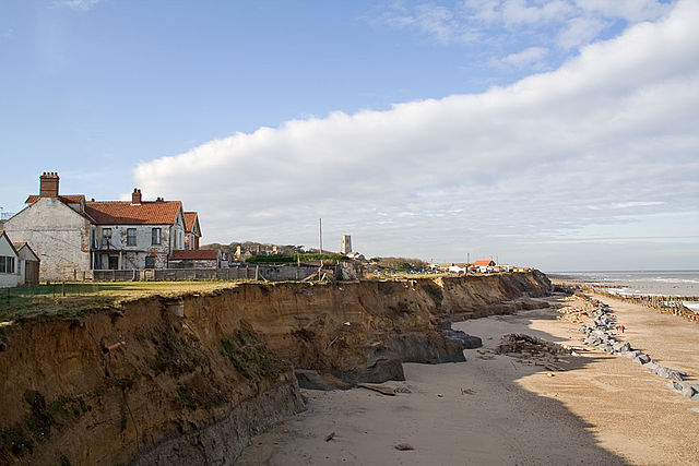
This shoreline is naturally retreating as winter storms in the North Sea erode the soft sediment of the cliffs. Towns such as Happisburgh are at risk as the sea cliffs erode.
We will consider the natural phenomena of coastal erosion and accretion and the human-induced changes on shorelines. We will weigh the pros and cons of the many engineering strategies (hard and soft engineering) that humans have devised to control shoreline changes. First, we will explore the concept of coastal erosion and the idea of the coastal cell by reading the article linked below.
What is coastal erosion, and when is it a problem?
Defining coastal erosion is rather straightforward. But to understand the phenomenon is far from easy. There is a widespread perception that coastal erosion is always irreversible, especially, for example, immediately after a storm event when erosion is more evident. This sometimes results in a call from both local residents and political representatives for hard engineering works to be constructed. There is little public awareness of the physics behind coastal processes that causes the difference between structural and episodic erosion. Few will know how natural coasts change due to fluctuations in forcing. And that erosion can be followed by coastal accretion when boundary conditions change, either at a seasonal, annual or much longer, geological time scale.
from Conscience-eu.net: What is Coastal Erosion and When is it a Problem? [3]
Required Reading
Read the following sections on the Conscience website, making notes as you go, with a focus on the details of the definition of coastal erosion and the processes at work in the coastal (or littoral) cell concept:
Learning Check Point
Please answer the questions below.
The Dynamic Coastline and Human Uses
The Dynamic Coastline and Human Uses
While maps typically delineate the transitions between land and sea with clear lines, in reality, the coastline is much less well-defined. The position of the coastline through time is highly variable, from the daily fluctuations of the water’s edge at beaches due to tides to the shoreline advance or retreat over hundreds of kilometers with geologic-scale or climatic influenced sea level fluctuations. As you read in the ConScience article, the coastline position does not just depend on sea level; instead, the supply of sediments to the coast and the processes responsible for their redistribution within a coastal cell are both responsible for coastal evolution. Coastal erosion removes material from the shoreline and redistributes it to other parts of the coastal cell. While erosion is usually most drastic during extreme events with associated high surges and waves, shoreline erosion can also occur gradually over a longer time period due to sediment deficits.
In modern times (decadal timescales), many of the world’s coastlines are characterized by erosion (approximately 70% of the world’s sandy coastlines are retreating). This widespread erosion is due to a variety of factors, most notably:
- global eustatic sea level rise that has occurred over the past century;
- global reductions in the supply of sediment reaching the coast (due to sediment impoundment behind dams, urbanization, etc.);
- human engineering at the coast that restrict sediment movement (harbors, seawalls, groins).
Coastal erosion is a naturally occurring process that can be exacerbated and becomes a significant problem when the dynamic coastline impinges on the fixed human infrastructure and uses within the coastal zone. Despite the potential risk of coastal erosion or flooding within the coastal zone, the majority of the world’s human population resides there, and in fact, numbers continue to grow as people migrate to coastal cities. Coasts continue to support the economic centers of the world, while at the same time critically ecologically important and sensitive natural habitats are supported by coastal zones. Coastal zones support a wide variety of human land uses. Tourist resorts, fishing communities, farming, aquaculture, and other land uses all vie for space on the coasts of the world, and often come into conflict with each other and with the dynamic interface between land and water. While inland areas are undoubtedly less vulnerable to coastal hazards, the coastal zone has been historically rich in resources and uniquely suited to support economic activities such as trade, industry, and tourism, attracting settlement and migration despite the elevated risks.
The primary impact of human activities within the coastal zone is the displacement of natural habitat with development, an increasing problem with continued coastal population growth. This issue will be examined in detail in Module 11 case studies. In the following pages, we will examine more closely the mechanics of coastal erosion and the human engineering strategies employed around the world to mitigate coastal erosion to sustain human land uses on the coast. We will question each approach in terms of sustainability in the context of the dynamics of the coastal zone and the increased challenges related to climate change.
These land use change maps of Egypt's Nile Delta [14], which are shown in the link below, show change over 24 years, between 1990 and 2014. Comparison of the two maps reveals many changes to the land-water interface on this coast. As you compare the two images, you will notice that the human activities that impact the coastline, such as fish farming and urban areas increase in area. The area of natural coastal lands decreases in area. Almost all urbanized coastal zones around the world will show complex land use changes such as these over the past few decades.
Coastal Protection and Mitigation
Coastal Protection and Mitigation
Along much of the world’s coastlines, the intersection of vulnerability (e.g., high populations, economic activities supported by the coastal zone) and coastal hazards (e.g., coastal erosion, coastal flooding) produces a risk that is unacceptable to the particular community and society, requiring the use of coastal protection measures to reduce the risk. The following sections detail some of the typical “hard” and “soft” coastal protection measures and how they impact risk and the environment in the coastal zone.
Coastal Protection Using Hard Structures
Coastal Protection Using Hard Structures
Coastal structures are frequently constructed to prevent erosion of coastal landscapes and infrastructure and mitigate the risks to the populations and economic activities dependent on the coastal zone. Coastal structures, sometimes referred to as “hard” structures, are usually built using materials (at least for certain coasts and beaches) that do not form naturally, such as of concrete, large armor stone, steel, or timber, are relatively permanent (typical 50-yr design life), and are spatially-fixed within an otherwise dynamic coastal zone. The most important hard structure types are dikes (levees), seawalls, breakwaters, groins, and jetties. The following descriptions are taken directly from the USACE Coastal Engineering Manual, the primary reference for coastal structure design in the U.S. Next, read about the hard structures and what each one does to protect the coast.
Sea Dikes
Sea Dikes
Sea dikes are onshore structures with the principal function of protecting low-lying areas against flooding. Sea dikes are usually built as a mound of fine materials like sand and clay with a gentle seaward slope in order to reduce the wave runup and the erodible effect of the waves. The surface of the dike is armored with grass, asphalt, stones, or concrete slabs (USACE, 2005).
Seawalls
Seawalls
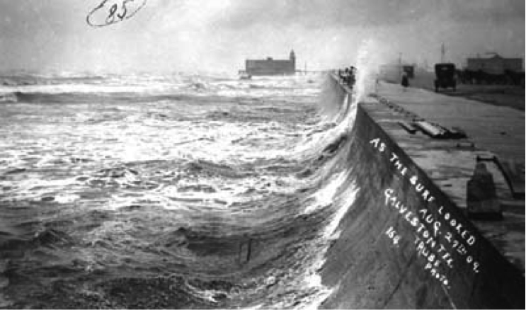
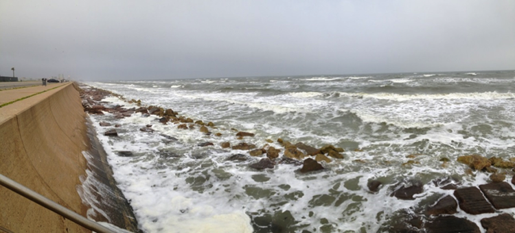
Seawalls are onshore structures with the principal function of preventing or alleviating overtopping and flooding of the land and the structures behind due to storm surges and waves. Seawalls are built parallel to the shoreline as a reinforcement of a part of the coastal profile. Quite often, seawalls are used to protect promenades, roads, and houses placed seaward of the crest edge of the natural beach profile. In these cases, a seawall structure protruding vertically or close to vertically from the beach profile must be built. Seawalls range from vertical face structures such as massive gravity concrete walls, tied walls using steel or concrete piling, and stone-filled cribwork to sloping structures with typical surfaces being reinforced concrete slabs, concrete armor units, or stone rubble (bulkheads, revetments, and Rip Rap are different types of seawalls).
Detached Breakwaters
Detached Breakwaters
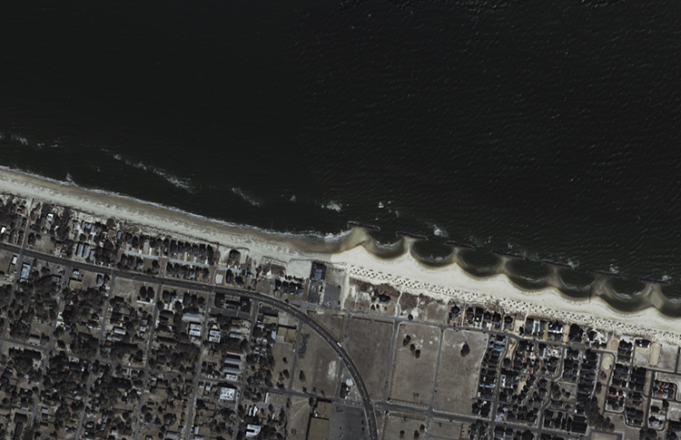
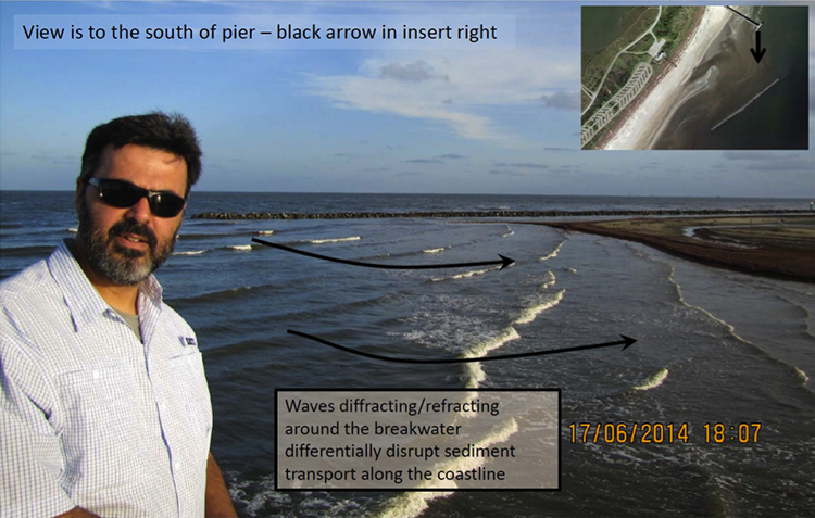
Detached breakwaters are small, relatively short, non-shore-connected nearshore breakwaters with the principal function of reducing beach erosion. They are built parallel to the shore just seaward of the shoreline in shallow water depths, using solid concrete structures, piles of stone/concrete blocks, or rubble mound. Multiple detached breakwaters spaced along the shoreline can provide protection to substantial shoreline frontages. The gaps between the breakwaters are in most cases on the same order of magnitude as the length of one individual structure. Each breakwater reflects and dissipates some of the incoming wave energy, thus reducing wave heights in the lee of the structure, interrupting transport along the shore, and reducing shore erosion. Beach material transported along the beach moves into the sheltered area behind the breakwater, where it is deposited in the lower wave energy region. The nearshore wave pattern, which is strongly influenced by diffraction* at the heads of the structures, will cause salients and sometimes tombolos to be formed, thus producing a shoreline similar to a series of pocket beaches. Once formed, there is positive feedback: the pockets will cause wave refraction, which helps to stabilize the pocket-shaped coastline. Breakwaters can also be constructed with one end linked to the shore, in which case they are usually classified as sea walls.
Recommended Reading
Read over Marine Biodiversity Wiki: Detached Breakwaters [15] to learn about these features.
The figures below illustrate the formation of salients (cusps of sediment protruding from the shore) and tombolos (larger cusps that attach to the breakwater), to form the pockets described above.
*(for a definition of Diffraction visit the Coastal Wiki website [17]).
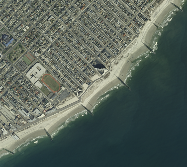
Groins
Groins
Groins are built to stabilize a stretch of natural or artificially nourished beach against erosion that is due primarily to a net longshore loss of beach material. Groins function only when longshore transport occurs. Groins are narrow structures, usually straight and perpendicular to the pre-project shoreline. The effect of a single groin is the accretion of beach material on the updrift side and erosion on the downdrift side; both effects extend some distance from the structure. Consequently, a groin system (series of groins) results in a saw-tooth-shaped shoreline within the groin field and a differential in beach level on either side of the groins.
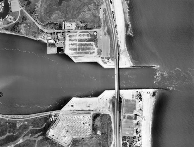
Jetties
Jetties
Jetties are used for the stabilization of navigation channels at river mouths and tidal inlets. Jetties are shore-connected structures generally built on either one or both sides of the navigation channel, perpendicular to the shore and extending into the ocean. By confining the stream or tidal flow, it is possible to reduce channel shoaling and decrease dredging requirements. Moreover, on coastlines with strong longshore currents and longshore sediment transport, jetties also function to arrest the crosscurrent and direct it across the entrance in deeper water where it represents less hazard to navigation. When extended offshore of the breaker zone, jetties improve the maneuvering of ships by providing shelter against storm waves. Jetties are constructed using methods and materials similar to breakwaters.
Disadvantages of Hard Structures
Disadvantages of Hard Structures
While hard coastal structures can be the most effective option for flood protection and/or mitigation, or for stabilizing a shoreline at a fixed position, there is a price to pay. Hard structures partially hinder the recreational use of the coastal zone and can cause adverse ecological effects within the coastal zone. For example, when seawalls are constructed on eroding beaches, the erosion continues so that the beach in front of the seawall can become very narrow or disappear completely. And while groins and jetties trap sediment on the updrift side, resulting in shoreline accretion, there is corresponding shoreline erosion on the downdrift side due to the interruption in longshore transport. Some of the disadvantages of hard structures include:
- Visual impacts
- Horizontal and vertical access restrictions
- Loss of sand supply to beach from armoring backshore
- Placement losses with construction of revetment or seawall
- Passive erosion
- Active erosion
Recommended Reading
Learning Check Point
Learning Check Point
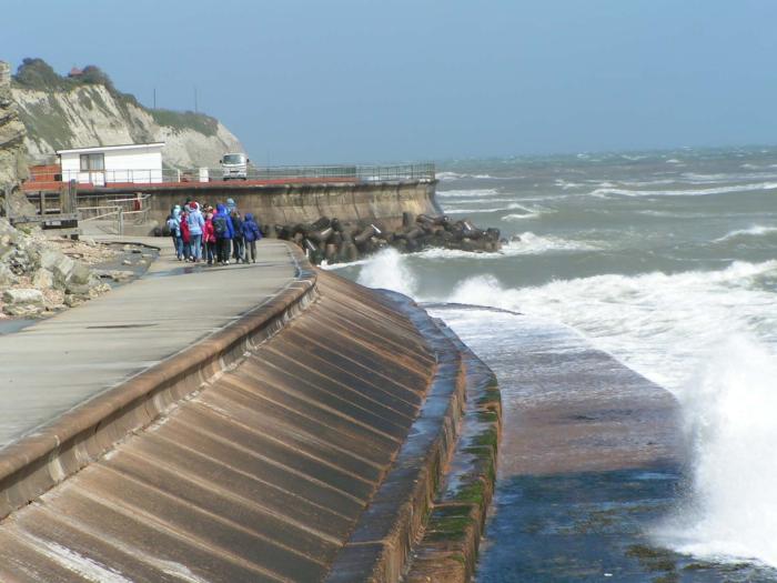
Look at the figure below and then answer the questions below.
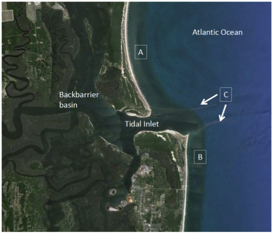
After examining the Coastline figure, consider how you would answer the questions below.
Coastal Protection Using Soft Structures
Coastal Protection Using Soft Structures
What is Soft Shoreline Stabilization?
It is the stabilization of the shoreline using environmentally friendly techniques used to protect property and uses from shoreline erosion. The main objective of soft shoreline stabilization is to achieve a balance between the need for protection against erosion while maintaining and enhancing shoreline functions.
Contrary to shorelines that are completely hardened with structures (described earlier), soft stabilization methods seek to incorporate key features into the design that either maintain or enhance functions of the shoreline, or those that allow natural processes to continue. But, natural processes, such as the movement of sand along a beach or barrier island or sediment moving along cliff coasts, headlands, etc., can vary widely between sites, making soft stabilization methods quite variant as well. Soft stabilization methods are highly dependent on local environments, and processes governing sediment pathways in each system. As such, additional planning for these methods may be required because of differences in coastal geomorphology, physical processes governing sediment transport, and because local ordinances vary across state boundaries.
As our understanding of the effects of hard stabilization methods increases, many traditional coastal engineering practices are slowly being phased out, especially where soft stabilization methods can replace or restore the ecological function, establish energy continuity, and offer sufficient protection. But, soft shoreline stabilization is a complex topic. Many federal and state agencies, including the National Oceanic and Atmospheric Administration (NOAA) Coastal Services Center, have been working for many years to implement programs to facilitate such protection practices with a fair amount of success. However, we still have a lot to learn before we can completely abandon hard structures. This is especially true if relocating communities that are at immediate risk is not possible (recall concepts in coastal vulnerability, exposure, and rising seas, from previous modules).
Required and Recommended Reading
Useful information on some approaches and guidelines:
Required:
Recommended:
Principles and Objectives of Soft Shoreline Stabilization
Principles and Objectives of Soft Shoreline Stabilization
Protection or mitigation of shorelines using soft approaches has some simple objectives and three basic principles.
The first principle is, try to imitate nature. Within each geomorphic environment, sediment characteristics, shoreline slope, and terrestrial and submerged habitat will be specific, hence using native plants and sediments that have already been exposed and shaped by forces within the specific coastal zone are critical to the success of soft mitigation methods. Plants help retain the soil matrix with their roots, and often offer good protection to erosion. On the other hand, if an area is subjected to higher energy conditions where vegetation is not naturally found, such as a beach, trying to steady the shoreline using vegetation along the high energy environment of the beach might not be a good idea. The fast-moving water and energy resulting from tidal currents and breaking waves will uproot the plants and quickly render the plants ineffective.
The second principle is, maintain gentle slopes. Unless we are in rocky coasts or regions with bedrock exposure, natural slopes where sediment is stable under gravity (less than the angle of repose) are relatively gentle. Maintaining a gentle slope allows for gradual dissipation of wave energy across a longer distance, hence the energy acting on each unit area is much lower compared to a vertical wall.
The third principle is, employ combined or mixed material approaches. Along many shorelines, we see a variety of terrestrial plants, various sediment sizes ranging from mud to sand or gravel, and shorelines are often lined with trees and other plants, and slopes can vary widely. Therefore, using a combination of approaches that imitates nearby natural shorelines is the best recipe for the successful implementation of soft approaches.
Methods of protection also often involve integrated approaches that include a combination of soft and non-traditional hard structure approaches.
Examples of Soft Shoreline Stabilization
Examples of Soft Shoreline Stabilization
There are many methods of soft shoreline stabilization with complex construction methodologies and materials. Here we will list a few examples for illustrative purposes in order to introduce the concept, and examine case studies that demonstrate how these methods work.
Soil Bio-engineering and Streambank Stabilization
Soil Bio-engineering and Streambank Stabilization
Case Study 1: Jacques-Cartier Park
Stream and riverbank protection efforts in populated areas are expected to address issues such as habitat, aesthetics, and water quality, as much as they address needs such as flood control and erosion protection. Therefore, integrated streambank protection designs that include vegetation are likely to satisfy these multiple objectives. Soil bioengineering is a method routinely used to address erosion and can be achieved in many ways across different systems. These systems utilize hybrid approaches that use geotextile fabrics and/or vegetation and can provide sound streambank protection while maximizing ecological and water quality benefits. These methods are used in place of riprap, concrete, or other inert structures alone. The Jacques-Cartier Park case study describes soil bioengineering systems that have been used to meet specific aquatic and riparian habitat objectives, and the procedures developed for this project are considered or have been used elsewhere where environmental concerns are placed high on the priority list, such as Alaska and the Ottawa River in Canada, which divides the Provinces of Ontario and Quebec.
Soil bioengineering methods have a common geotechnical benefit of providing root reinforcement in the soil and can help modify drainage patterns of the soil, help stabilize soils at steeper angles if desired, help keep grasses, and bushy vegetation in place resisting erosion, and support woody debris or other types of vegetation. The species of woody vegetation selected for inclusion in soil bioengineering systems can have a significant effect on the habitat benefits. While various species of willow are the most common woody plants used in soil bioengineering because of their excellent rooting ability, good overhanging cover and shade for streams, good nesting habitat for some species of birds, and some cover for mammals, it is not noted as an excellent food source for land animals, nor it is suitable for saline systems and may have limited applications in coastal settings.
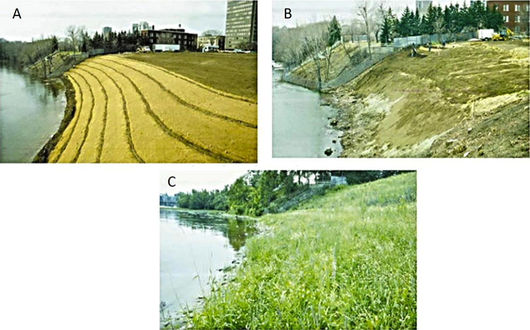
As part of the remediation of the Jacques-Cartier Park site, contaminated soils and materials were excavated and replaced with a sand/clay subsoil mix (A) and the resulting embankment was then topped off with a new topsoil blend. The steepness of the constructed slope and the presence of the river below required using live fascines (bundles of brush) on the contour with erosion control fabric made of coir (fiber from coconut husk) to provide surface stability (B). Other project objectives for this case study included preparing a foundation where, over time, a natural community of indigenous plant materials for upland and riverine habitat would evolve, thereby improving aesthetics and establishing a long-term, maintenance-free natural slope along the Ottawa River within its highly urbanized context. The success of this project to meet the desired goals enabled Public Works to designate the area as an extension of Jacques Cartier Park (C).
Case Study 2: Waquoit Bay Preserve, Massachusetts
In this more coastal example, the Massachusetts Office of Coastal Zone Management Stormsmart Coasts Program provides guidance to property owners wishing to use bioengineering techniques to stabilize shorelines on their property. The use of a matting material made of coconut fiber called coir logs is used in combination with planting native vegetation. This is described in StormSmart Properties Fact Sheet 4: Bioengineering - Coir Rolls on Coastal Bank [22], a public information brochure provided to the public on the Mass.gov website. In another example, Wilkinson Engineering was employed to stabilize a shoreline on Waquoit Bay in Massachusetts. They used a variety of methods, including changing the angle of slope, installing "coir" matting to stabilize the bank, and establishing fringing marsh at the base of the slope.
Recommended Resource
Bioengineering Strategies: Reducing Coastal Erosion and Coastal Storm Damage While Minimizing Impacts [23] illustrates the series of steps employed in bioengineering to stabilize a coastal shoreline on Waquoit Bay. Take a look at this richly illustrated document explaining the process.
Geosynthetics – Geotubes/Geotextiles
Geosynthetics – Geotubes/Geotextiles
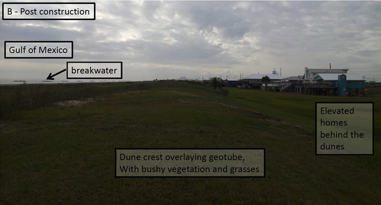
Case Study 3: Hurricane Protection in Grand Isle, Louisiana, USA
Geotextiles or geosynthetics have become very popular methods for several streambank stabilization projects, dune stabilization, and generally when earthen stability is required. A geotextile material that can be chosen varies in thickness and porosity and will depend largely on soil properties or whether it is necessary to improve a soil property – for instance, to increase surface soil strength, increase erosion resistance, or stabilize weak soils on steep slopes. For the case study in Grand Isle, LA, the objective was to protect the island from storm waves and storm surge, a function that is typical of a dune system. However, the island is highly exposed to the Gulf of Mexico storm waves that frequently overwash and erode the dune system, with increasing dune rebuilding costs after each storm. To protect against this erosion, coastal engineers employed geotubes, which were filled with native material excavated from the existing storm-damaged dune system. Once put in place, the tubes were covered with a top layer of sand and were vegetated for added soil stability. Over time, wind-blown sand from the beach system accumulates at the seaward side of the dune system and organizes into smaller dunes, where additional vegetation growth takes place and provides additional protection from waves and storm surges approaching the island.

Coastal Dune Protection and Restoration
Coastal Dune Protection and Restoration
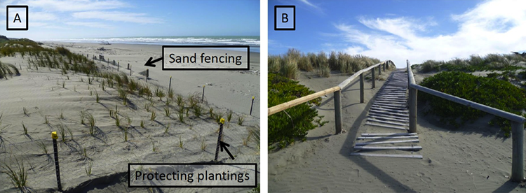
Case Study 4: Dunes in Massachusetts
Sand dunes are common features in coastal zones and desert environments. Along the coast, dunes can protect beaches from erosion during storms and supply sand to a beach that is eroding. Dunes also provide habitat for highly specialized plants and animals, including rare and endangered species. Because of threats by both intentional and unintentional human activity and because of the benefits they offer, such as storm protection and sediment cycling between dune and beach environment, many countries such as the Netherlands, United Kingdom, and the United States employ dune protection programs. These include stabilization programs and restoration efforts centered on building or re-building dunes. Protection, stabilization, and restoration methods utilize measures to reduce the transport of sand by wind and water, such as planting vegetation, constructing sand fences, and selecting access areas that avoid damage to dunes and dune vegetation from foot traffic.
It is important to consider dune structure when planting dune vegetation. Dunes are composed of the foredune (the part that faces the ocean), the sand plain (the dune crest or top), and the backdune (the side facing away from the ocean). The micro-environments of these dune components limit the types of plants that can thrive on them. For instance, foredune plants need to be tolerant to salt spray, strong winds, and some burial by wind-blown sand from the berm and beach environment, while sand plain and backdune plants can be less tolerant of these stresses because they are typically protected from salt spray and sand burial.
Managing coastal dunes for use as part of a flood protection and mitigation strategy involves an integrated management approach or plan, which follows closely with some of the principles we introduced for soft shoreline engineering. These are to:
- restore and preserve natural processes (that is, work with nature);
- create conditions and opportunities for establishing future natural processes (that is, maintain mass and energy flow);
- prevent land use practices that hinder any of the above.
In the Cape Cod area of Massachusetts, erosion caused by winter storms, in particular, results in loss of beach area. And one solution put into practice to address this issue is dune restoration using sand fencing to trap sand and build new dunes. This technique, in concert with planting suitable beach grass species to hold the sand in place, can be a very effective method.
Recommended Resource
The document "Coastal Dune Protection and Restoration [25]" from Woods Hole Sea Grant and Cape Cod Cooperative Extension provides excellent details and illustrations of the process.
Advantages and Disadvantages of Soft Shoreline Stabilization
Advantages and Disadvantages of Soft Shoreline Stabilization
Alternative soft stabilization approaches can offer many benefits over typical hard stabilization structures. Often these approaches are referred to as living shorelines because they offer added ecological benefits. Some of the benefits of soft stabilization approaches include:
- maintaining natural shoreline dynamics and healthy sand movement across a coastal cell;
- trapping sand to rebuild eroded shorelines or maintain current shoreline form;
- providing or enhancing important shoreline habitat;
- reducing wave energy impacts at or seaward of the shoreline;
- absorbing storm surge and floodwaters;
- filtering nutrients and other pollutants from the water;
- maintaining beach and intertidal areas that offer public access opportunities for wading, fishing, and walking;
- reducing the costs of stabilization from bulkheads, rip rap, and other hard structural approaches;
- creating a carbon sink and thereby helping mitigate climate change.
While there are many benefits associated with living shorelines, they are not appropriate for all geomorphic environments. Drawbacks for living shorelines include:
- not being appropriate for high energy environments;
- not being as effective where much of the shoreline is already hardened;
- being more difficult to design and install than more traditional hard structural approaches;
- having limited information available on the effectiveness of living shorelines for different types of shorelines, energy regimes, and storm conditions.
Earth Systems in Action: Development and Coastlines
Earth Systems in Action: Development and Coastlines
As you have just discovered, humans have undertaken a wide range of initiatives to try and protect some coastlines and limit the amount of coastal erosion that is taking place. These initiatives include the construction of hard protective structures such as breakwaters and seawalls or the imitation of natural processes that include the placement of sediment in key locations or planting vegetation to stabilize loose unconsolidated sediment. The decision to use one method over another is extremely complex, requires a solid understanding of the system to be protected, and consideration of the economics and politics of a project.
Suppose, for example, that you own beachfront property and historically the beach in front of your house has been retreating landward, toward your house, at a rate of a meter per year for the last decade because of the combined effects of erosive storms and reduced sediment supply. On the basis of the historic trend, it is clear that within another decade the waves will be at your door. It is clearly, then, in your best interest to develop some sort of project that will help reduce the erosion and cause the beach to begin building seaward again. What are your options?
You could go to the local city council and suggest that a series of groins be placed along the beach in a location that will help trap sediment carried by longshore transport. For this to be effective, you would, however, need to have an excellent understanding of the longshore transport patterns on a daily and longer time frame. Placement of the groin in the wrong place could actually have a negative effect on the beach at your property (depending on the direction of transport) and enhance the erosion. Additionally, you would have to consider the impact of such a structure to the neighboring beaches. Do you think that your neighbors would advocate for structures to protect your beach if it would then also cause erosion in front of their properties? What about the cost of such a structure and who would pay for it? Projects such as this can cost millions or tens of millions of dollars, and you do not have the finances to cover the costs. So, who will pay for it? Suppose I am a taxpayer in a more landward located county. Do you think I would advocate for my taxes to be used to protect your beach-front property if the school my kids attend needs new technology and computers that are normally paid for by the same tax money?
In this example, numerous systems need to be considered, ranging from the natural longshore transport system to the local economic and political system. It is clear that situations such as this are extremely complex and require careful planning and implementation, and, in most cases, not everyone is content with the final outcome.
Module 8 Lab
Module 8 Lab
Introduction
The objective of this Lab is to help you develop an appreciation for coastal erosion and associated risks when placing major infrastructure proximal to coastal hazards.
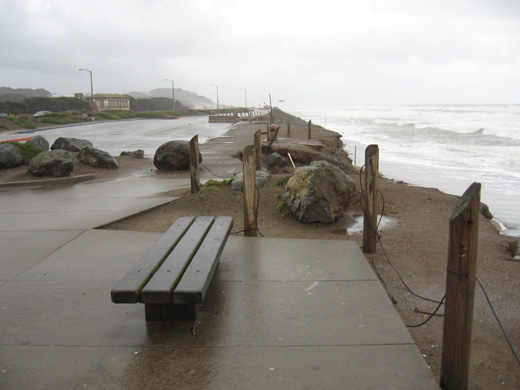
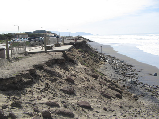
Ocean Beach is a sandy beach backed by erodible bluffs that form the boundary between the western edge of the city of San Francisco, CA and the Pacific Ocean. Like many sandy coasts around the world, portions of Ocean Beach have experienced significant erosion in the past decades. The long-term erosional trend along the southern reach of the beach has been punctuated by periods of intense erosion during particularly severe winter El Niño storm seasons, when the beach and backing bluffs can be exposed to very high waves.
The situation is complicated by the presence of critical infrastructure within the coastal zone. The Great Highway, an important transportation link, is located on top of the bluffs backing Ocean Beach, and recent erosional events damaged parking areas and forced the closure of one direction of traffic for much of the storm season. More importantly, a large sewage tunnel runs under the Great Highway, transporting the city’s wastewater south to a treatment plant. Continued erosion threatens this piece of expensive, critical wastewater infrastructure, and it must be protected in the near term to prevent both the environmental consequences of a tunnel failure and the huge cost of relocation. During the most intense erosion episode during the 2009-2010 El Niño winter, the city constructed an emergency revetment of armored stone along the eroding bluff to protect the wastewater infrastructure; however, the use of “hard” coastal protection structures met stiff opposition from environmentalists and local regulatory agencies due to the inevitable loss of beach in front of the structure.
Required Reading
Be sure you have read "SPUR: The Future of Ocean Beach," located on the Module 8 Roadmap. The article details the coastal erosion and management issues at Ocean Beach.
Lab Overview
After you thoroughly read the article “SPUR: The Future of Ocean Beach” (mentioned above, follow the steps in the Module 8 Lab Worksheet below.
Downloads/Resources
Instructions
Before you begin the Lab, you will need to download the Lab worksheet. We advise you to either print or download/save the Lab worksheet, as it contains the steps you need to take to complete the Lab in Google Earth. In addition, it contains prompts for questions that you should take note of (by writing down or typing in) as you work through the Lab.
Once you have worked through all of the steps, you will go to the Module 8 Lab to complete the Lab by answering multiple-choice questions. The answers to questions on this Lab worksheet will match choices in the multiple-choice questions. Submit the quiz for credit.
Summary and Final Tasks
Summary and Final Tasks
Summary
In Module 8, you have learned about the various traditional "hard" structures used in coastal engineering for shoreline stabilization and flood protection. However, hard structures partially hinder the recreational use of the coastal zone and can cause adverse ecological effects within the coastal zone. Groins, and jetties in particular, interrupt longshore sediment transport, causing updrift accretion and downdrift erosion of the shoreline. Soft shoreline stabilization methods offer an alternative to hard structures by using environmentally friendly techniques that enhance ecological functions and allow natural processes to continue. In the activities, you viewed different coastal areas with erosional shorelines, learned how to measure the long-term erosion rates, and became familiar with some of the complications of real-world problems where choices between the use of hard or soft structures must be made.
Reminder - Complete all of the Module 8 tasks!
You have reached the end of Module 8! Double-check the Module 8 Roadmap to make sure you have completed all of the activities listed there before you begin Module 9.
References and Recommended Reading
- U.S. Army Corps of Engineers. (2002). Coastal Engineering Manual. Coastal Engineering Manual (pp. 1–62). Washington, D.C.: U.S. Army Corps of Engineers. doi:10.1093/intimm/dxs026
- Larson, M., Hanson, H., & Kraus, N. C. (1987). Analytical Solutions of the One-Line Model of Shoreline Change.
- IPCC. (2007a). Climate Change 2007 - The Physical Science Basis: Working Group I Contribution to the Fourth Assessment Report of the IPCC. (M. Tignor & H. L. Miller, Eds.)Science (p. 1009). Cambridge University Press.
- IPCC. (2007b). Climate Change 2007: Impacts, Adaptation and Vulnerability. (M. L. Parry, O. F. Canziani, J. P. Palutikof, P. J. Van Der Linden, & C. E. Hanson, Eds.)the Intergovernmental Panel on Climate Change (Vol. 114, p. 976). Cambridge University Press. Retrieved from http://www.ipcc.ch/ipccreports/ar4-wg2.htm [31]
- Barnard, P. L., Hansen, J. E., & Erikson, L. H. (2012). Synthesis Study of an Erosion Hot Spot, Ocean Beach, California. Journal of Coastal Research, 28(4), 903–922.
- Bosboom, J., & Stive, M. J. F. (2010). Coastal Dynamics 1: Lecture notes CT4305. Delft, the Netherlands: Delft University of Technology, Faculty of Civil Engineering and Geosciences, Section of Hydraulic Engineering.