Welcome
Before we begin our semester of study together, it is important that you review all of the material on all these pages and on our Course Syllabus. These resources will prepare you to be successful in this course.
Have you looked at our Fall Syllabus [1] and Spring/Summer Syllabus [2]? This Course Orientation will complement and expand on the information provided on our Syllabus. Be sure to review the Syllabus carefully. A link to the Syllabus is also located in the main navigation bar.
What will we learn about in the Course Orientation?
- the structure of Earth 107
- what assignments are required in this course
- an overview of Canvas, Penn State's learning management system
- technical requirements for Earth 107
- how to succeed in this course
- where to get course assistance if you need it
What is due for the Course Orientation?
You should complete the Course Orientation during the first week of class.
The following is an overview of those activities that must be completed for Course Orientation. Detailed directions and submission instructions are located within this Course Orientation or in Canvas.
(Note: You may want to print this page to serve as a checklist as you go along.)
Orientation Roadmap
| Tasks | Location |
|---|---|
| Read over the Course Syllabus. (This will include overview, structure, assignments, grading, policies, technical requirements, etc.) | Fall Syllabus [1] and Spring/Summer Syllabus [2] |
| Read the Course Introduction and Goals. | Course Introduction and Goals in this Orientation |
| Read How to Succeed in Earth 107. | How to Succeed in Earth 107 in this Orientation |
| Meet Your Instructor. | Meet the instructor [3] in Resources |
| Download Google Earth Pro and complete the tutorials. | Google Earth Download and Tutorials [4] in Resources |
| Read about the Capstone Project. | Capstone Project [5] in Resources |
| Find out how to get help in this class. | Getting Help [6] in Resources |
| Set up course communications and notifications. | Required Canvas Notification Settings - Orientation Module in Canvas |
| Learn about Modern Earth Science Principles. | Modern Earth Science Principles |
| Take the Course Orientation Quiz. | Course Orientation Quiz in Canvas |
Questions?
If you have questions, please feel free to post them to the discussion forum for this module in Canvas. While you are there, feel free to post your own responses if you, too, are able to help a classmate. Remember, if you have a question that is more personal in nature, please use the email tool in Canvas.
What is next?
Once you are ready, click the next link in the orientation menu and work all the way to the end of the list.
Earth 107 Course Introduction and Goals
Earth 107 Course Introduction and Goals
It seems that each year brings new and bigger disasters to coastal communities around the world. Summer 2017 brought Harvey to Houston, Irma to the Caribbean, and Florida and Maria to the Caribbean. Each storm had its own uniquely devastating effects on a range of communities that are, at the time of writing, six months later still struggling to recover. Looking further back in time now, there were Hurricane Katrina (2005), Super Storm Sandy (2012), Super Typhoon Haiyan (2013), the Tsunami of Christmas 2004, and the Japanese Tsunami of 2011. We have become familiar with images on our screens of the devastation and misery that result from these natural disasters.
But how are these disasters linked to earth science? How can we understand the underlying causes better in order to learn to live in a more harmonious way with nature to create more resilient coastal communities? Can we do a better job at protecting people from coastal hazards? Can our actions influence the impacts of storms and other destructive events?
These are some of the larger questions we will consider in Coastal Processes, Hazards, and Society.
The two events in the U.S. that grabbed everyone’s attention and began to influence thinking about these questions were Hurricane Katrina and “Super Storm” Sandy.
These two storms alone resulted in the inundation of large, densely populated areas – killing thousands of people and flooding tens of thousands of houses, businesses, schools, hospitals, and crippling infrastructure. Many stressful years have been spent in recovery; difficult decisions have been made by individual homeowners, business owners, municipal and state governments, and federal agencies about how to move forward following these disasters.
Currently, 10% of the world’s population (approximately 600 million and growing) live on land that is within 10 meters in elevation from sea level. Some of the world’s most populated regions lie within this elevation range. In many regions, migration to these population centers is occurring at a rapid pace. These low-lying cities include London, New York, Miami, and Tokyo, as well as Mumbai in India and the rapidly growing megalopolis of Guangzhou in China, and other large cities we may rarely think about. Numerous smaller, little-known communities are equally precariously located but come into sudden focus when a disaster hits. Why have our cities grown and continue to grow in these low-lying and increasingly vulnerable locations? Why do we allow so many people to live in places at high risk of coastal impacts?
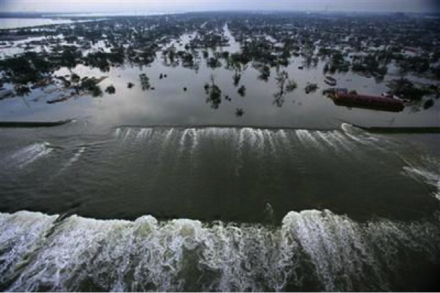
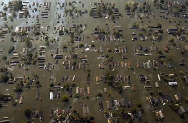
New Orleans is often the poster child for cities exposed to coastal hazards; but it is certainly not the only vulnerable coastal city, and it does not sit right on the shoreline as Miami does, for example. So, what is it that makes it so vulnerable? Many factors contribute to coastal vulnerability, and this will be explored in great detail, especially in Unit 4 of the course. In simplified terms, the frequency and intensity of the coastal hazards; the physical setting (geology, landforms, etc.) of the place, and the socio-economic conditions of the residents contribute to the overall vulnerability of a place. When Katrina hit New Orleans, many factors made the city particularly vulnerable and led to the inundation of 80% of the city and the temporary displacement of all of its residents, and the permanent displacement of many.
In 2005, Katrina was the deadliest and costliest storm to make landfall in the United States in 100 years. It impacted coastal communities in five Gulf Coast states: Florida, Alabama, Mississippi, Louisiana, and Texas. Its greatest impacts were felt in Louisiana and Mississippi, and the greatest media attention was given to these effects in New Orleans. Katrina’s death toll was approximately 1500 in Louisiana alone. The economic impacts were complex and enormous. If measured by insurance claims alone, the disaster generated more than 1.7 million claims across six states, up to a total of more than $40 billion.
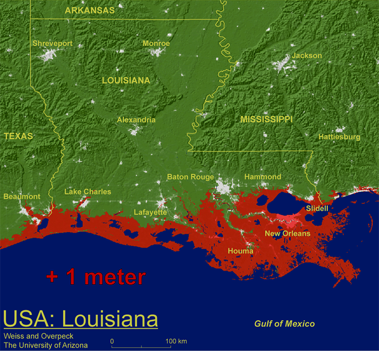
More than a decade has passed since Katrina, allowing for many lessons learned to influence policy changes, and for new defense structures to be built to protect the city, much of which sits below sea level in an artificially created bowl on a sinking river delta. So, although New Orleans is currently seeing an economic boom and a surge of optimism as residents see and experience progress towards recovery, the question must be asked: How long can New Orleans expect to be protected from a future major hurricane? The sea level rise prediction map shown below raises many questions. We will address many of these questions during this course. Not least, the questions: WHY are the delta wetlands surrounding New Orleans likely to be inundated during the next century, and what should the residents be doing now to prepare for the future?
Course Goals
The purpose of this course is to enable students to analyze and understand the complex physical and social processes that form coastal zones, expose landscapes, people, and property to coastal hazards, and make them vulnerable to those hazards. Therefore, by the end of this course, students will demonstrate that they can:
- demonstrate geospatial skills and concepts;
- explain the evolution of coastal morphology;
- link physical and social impacts of coastal hazards;
- evaluate engineering options to mitigate coastal risks;
- assess vulnerability to coastal hazards; and
- create a plan for responding to coastal hazards.
These are the six goals of Coastal Processes, Hazards, and Society.
How to Succeed in Earth 107
How to Succeed in Earth 107
Here are some quick tips to keep in mind when preparing to be successful in an online course:
Treat online learning as you would a face-to-face class
You should plan to devote at least the same amount of time to your online courses as you would to attending lectures on campus and completing assignments. Other good study habits, such as attending class (logging on) regularly and taking notes, are just as important in an online course as they are in a lecture hall!
Intentionally schedule your time
You should plan to devote 10-12 hours per week to completing lesson readings and assignments. Your learning will be most effective when you spread this participation out and engage with the course on a daily basis, if possible.
Engage, Engage, Engage!
Take every opportunity to interact with the content, the instructor, and your classmates by completing assignments and participating in discussion forums and group activities!
Be organized and Keep up!
Keep in sync with what's going on in the course and stay on top of deadlines and upcoming assignments. If you fall behind it can be very tough to catch up.
Ask for help!
Ask for guidance when you are in need of clarification. You can also use the Yammer Earth 107 Discussion (see Getting Help) to ask general questions about the course set-up or content. Or email the instructor directly through Canvas.
Other Resources
The links below will connect you with other resources to help support your successful online learning experience:
-
Penn State World Campus Strategies to Improve Online Learning [10]
This website provides links to many resources on everything from taking notes online to managing your time effectively. Please note that you must be a World Campus student to receive some of the support services mentioned on this website.
-
Tutoring and Technology Resources [11]
As a student, you have access to several resources to help you improve your understanding of the course material, or learn how to better use the technology needed for your courses. This website provides instructions and links for accessing online tutoring, writing help, and assistance with learning technology.
-
Penn State World Campus - The Corner of College and Allen Blog [12]
This blog features posts by Penn State staff and students on a wide variety of topics relevant to online learning. Learn from online students and alumni, as well as staff members dedicated to student success, how you can get the most out of your online course experience.
-
Penn State iStudy Online Learning Tutorials [13]
The iStudy online learning tutorials are free and available to all Penn State students. They cover a broad range of topics including online learning readiness, time management, stress management, and statistics - among many others. Check out the extensive list of topics for yourself to see what topics may be of most use to you!
-
LinkedIn Learning at Penn State [14]
This website provides access to an extensive free online training library, with tutorials on everything from creating presentations to using mobile apps for education. There is a wealth of information here - all provided free of charge to Penn State faculty, staff, and currently enrolled students.
Modern Earth Science Principles
Modern Earth Science Principles
The Earth System
Many of you have not had an Earth Science class before, so it is necessary to prepare you for a new way of thinking – formally known as systems thinking – that you will be practicing throughout the class. Please pay attention to the following, as we do ask you a few questions about it in the Summary and Final Tasks.
The Earth is a wonderful, big messy pile of rock, water, and air with life teeming all over it, and Earth scientists are used to dealing with this messy and highly complex system. But you are not, so let's simplify things to start. The Earth is an integration of four systems or spheres: air, water, land, and life. Technically speaking, these are known as the atmosphere (air), hydrosphere (water), lithosphere (land), and biosphere (life).
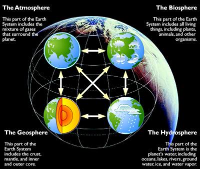
Four images of a globe to symbolize the four spheres.
The atmosphere: This part of the Earth system includes the mixture of gases that surround the planet.
The Biosphere: This part of the Earth system includes all living things, including plants, animals, and other organisms.
The Geosphere: This part of the Earth system includes the crust, mantle, and inner and outer core.
The hydrosphere: This part of the planet's water, including oceans, lakes, rivers, groundwater, ice, and water vapor.
Modern Earth Science is focused on the connections between the spheres and this approach is extremely relevant in this course. The coastal zone is at the intersection of the lithosphere and the hydrosphere, and, as we will see, the ocean has a major impact on landforms along the coast. Now, in the case of Katrina, or any hurricane for that matter, the storm was formed and is part of the atmosphere. And, as you know, the storm caused a very severe toll on humans (biosphere). Humans have made the coastal zone their preferred home; ten percent of the world’s population, or approximately 600 million people, live on land that is within 10 meters of sea level. And as we will see, large storms are forecast to increase in the future, and sea level is rising, placing these communities more and more directly under the crosshairs of the ocean. Governments are well aware of the threat and are actively considering policies to manage coastal communities.
Even more devastating than hurricanes are tsunamis, and the last decade has witnessed two of the worst in human history. Tsunamis are giant waves in the ocean (hydrosphere), triggered by earthquakes (a primary force in the lithosphere), and have deadly consequences on coastal communities (the biosphere). The Indian Ocean tsunami in 2004 crashed ashore at heights over 100 feet and killed more than 230,000 people in fourteen countries; the Tohoku tsunami of 2011 reached heights over 130 feet and killed over 15,000 in Japan.
During the course of the semester, we will consider the interactions between the different Earth systems on a continual basis. In Units 1 and 2, we consider the lithosphere, hydrosphere, and atmosphere and how they interact with each other and have consequences for the anthrosphere. In Units 3 and 4 we will focus on how humans can adapt the coastal zone to mitigate the threat of sea level rise, hurricanes, and tsunamis through engineering and policy.
The techniques of modern Earth sciences: How Earth scientists think
Because Earth scientists are continuously working at the intersection between the spheres, their field is by necessity an integrative one, meaning that the techniques that they use are built upon the connections of the Earth, air, water, and life. As we mention above, these connections are inherently complex and subject to great changes over time. Thus Earth scientists are accustomed to dealing with complexity, fluctuation, and uncertainty, and you will see good examples of each of these factors throughout the semester. These are some of the fundamental concepts of systems thinking.
Feedbacks and Linearity
The complex connections between processes involve what are known as “feedbacks.” These are mechanisms that dampen or accelerate the impact of one process on another. Sounds complex? The best way to explain a feedback is to give an example and the best example involves the growth of ice such as in a glacier. Ice reflects sunlight better than almost any other material on Earth, and in reflecting sunlight, it lowers the amount of energy from sunlight absorbed by Earth, which makes it colder. If the Earth becomes colder, glaciers may grow, covering more area, and reflecting even more insolation, which in turn cools the Earth further. Thus, cooling instigates ice expansion, which promotes additional cooling, and so on — this is clearly a cycle that feeds back on itself to encourage the initial change. Since this chain of events furthers the initial change that triggered the whole thing, it is called a positive feedback. There are also examples of negative feedbacks whether the chain slows the change that triggered the events. We will point examples out to you in the modules.
Moreover, when you really get involved in studying processes on Earth, you will find out that some variables are related to one another in a linear fashion; for example, an increase in variable X leads to a doubling of variable Y, but in fact, many processes are related in a non-linear way. At the level of this course, we will not be exploring linearity and non-linearity in much detail, and as you can imagine, most of the processes we discuss are non-linear.
Big Data
The considerable threat of events such as sea level rise, hurricanes, and tsunamis to humankind has provided a boost to the Earth sciences, broadly defined to include geoscience, geography, atmospheric science, and oceanography. Massive datasets are now available to study the Earth, and with technology that can handle terabytes of data in a heartbeat, this is an extraordinarily exciting time to be an Earth scientist. We will introduce you to a lot of data in this course. In the coastal zone, for example, satellite data provide elevations at centimeter accuracy and we can monitor how processes such as sea level rise and hurricanes are impacting the shoreline.
So, we point out examples of complexity, feedback, and Earth Systems in the modules. Whenever you see "Earth Systems, Complexity, Feedback IN ACTION" pay attention!
If you want to read more about how we Professors want you to think, check this page out:
Science Education Resource Center [15]
We hope that this course brings a lot of the enthusiasm that is permeating modern Earth science.
Summary and Final Tasks
Reminder: Complete all of the Course Orientation tasks!
You have reached the end of the Orientation! Double-check the roadmap on the Orientation Welcome page [16] to make sure that you have completed all of the activities listed there before you begin Module 1.