Nearshore, Beaches, and Dunes
Nearshore, Beaches, and Dunes
How can beaches be zoned? What is the basis for this zonation: morphology or process? Why are some beaches steep and higher gradient than other beaches? What processes can drive sediment exchange between the nearshore, beaches, and dunes? How does the storm profile of a beach look compared to the fair weather profile for the same beach? If ample sediment is available, what can happen to a beach following a major loss of sediment? Can it recover? How?
For many of you, the concept of the nearshore, beach, and dunes probably conjures ideas such as swimming about in breaking waves, games of Frisbee on a sandy surface, or heavily vegetated mounds of sediment that have to be crossed in order to reach the beach. From a coastal geologist's morphological perspective, each of these has a unique definition, where the:
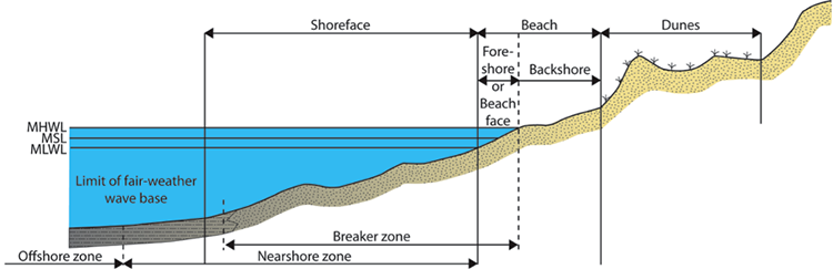
- nearshore is a broad classification defined as the region extending from the land water interface (shoreline) to a location just beyond where the waves are breaking,
- beach is defined as the zone of unconsolidated material that extends landward from the low water line to a place where there is a marked change in physiographic form or a line of permanent vegetation representing dunes,
- dunes are defined as topographically elevated ridges and or mounds that may be heavily vegetated, but are formed as sand is transported by wind and subsequently deposited.
Each of these environments is unique in form and composition and is characteristically molded by fundamentally different processes that act to modify each environment on a daily or longer timescale
Zonation by Tidal Elevations
Another convenient and slightly more simplistic way of dividing the nearshore through dune system is to recognize areas along such a transect as a function of where they lie relative to the tidal range for the area. In this sense, the nearshore through the dune system can be divided, on the basis of elevation relative to mean sea level, into subtidal, intertidal, and supratidal zones.
- Supratidal zone: is situated above the high tide elevation and only occasionally is flooded, most commonly during high spring tides and storms. It includes the uppermost part of the beach as well as the dunes, and so, the non-storm process acting to transport sediment in this area is wind (aeolian transport). In this context, this area is recognized as the backshore and dunes zone.
- Intertidal zone: is located between the normal low and high tide levels. This zone is therefore repeatedly inundated by water and exposed to air. This also represents the zone where waves are routinely interacting with the land, leading to daily transport of sediment. In the image above this area is recognized as the foreshore or beachface.
- Subtidal zone: consists of regularly submerged, relatively shallow water area seaward of the intertidal zone. Waves and tides are always acting to move sediment in this environment. In the image above, this area is recognized as the shoreface.
Nearshore
Nearshore
An examination of nearshore zones on a global basis reveals that they are characterized by a wide variety of morphologies, which are dependent upon the wave and tidal conditions as well as the size of sediment that is present. Overall, it is a zone in which there is generally the capability for significant sediment transport both perpendicular to the beach as well as alongshore because of longshore sediment transport by wave action. In some nearshore systems, there may be a variety of alongshore bars or ridges of sediment that can eventually migrate landward and attach to the beach and thereby contribute to the seaward extension of the beach.
Beach
Beach
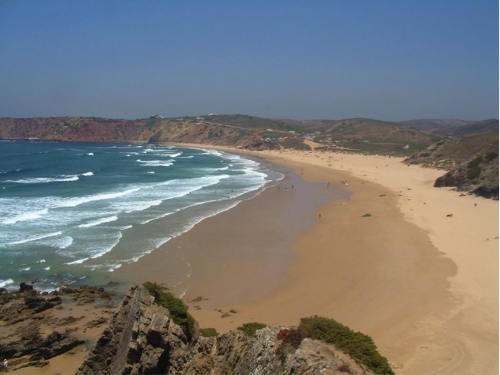
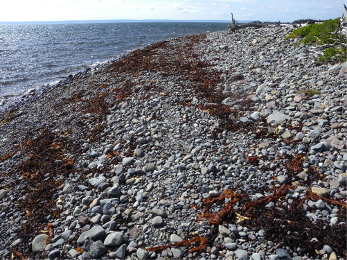
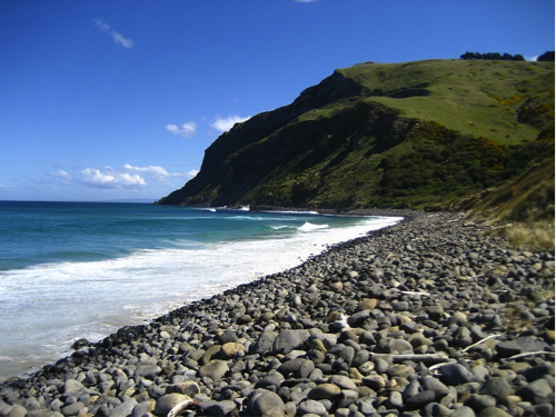
The beach is located landward of the nearshore zonation and can consist of a wide range of sediment types including pebbles, gravel and even sediment particles that are as large as boulders. The composition of a beach can also be highly variable, and sediment on a beach can be anything from grains of the mineral quartz to fragments of calcium carbonate shell produced by shelled organisms. The size of the sediment as well as the composition of the sediment that is located on a beach is wholly a function of the character of the sediment that is available at that location. Because beaches are constantly being influenced by the impact of waves and by changes in the elevation of the water levels because of tides, they can be extremely dynamic environments, capable of undergoing drastic changes in morphology within a timescale that ranges between nearly instantaneous to seasonal or longer.
During high energy events, such as large storms or tropical cyclones, waves increase in size and therefore are more capable of eroding sediment from a beach and transporting it either farther offshore or along the shoreline to a new location in very short periods of time. During longer time periods, similar results can occur even during fair weather when low energy waves are affecting the beach. In general, however, most beaches undergo the most substantial erosion and loss of sediment during storm events and then experience a period of recovery to regain a cross-sectional profile that is in equilibrium with the wave and tidal conditions.
The slope of beaches can also be highly variable and is a function of the composition of the beach and the characteristics of the waves impacting the beach. Consider what happens as a wave breaks and the swash of the wave runs onto the beach and then returns. As a wave breaks onto a beach, it rushes up the slope of the beach and carries some sediment with it. The energy of the wave is expended due to friction with the surface and the pull of gravity downslope on the beach. As the water of the wave returns downslope, referred to as backwash, it still carries some sediment with it. However, if the beach is very coarse-grained, then the backwash can rapidly percolate into the subsurface and very little water remains to carry sediment back down the beach to the sea. In this case, any sediment carried up the beach by the breaking wave becomes stranded at the landward limit of the breaking wave, and no backwash is available to carry sediment back down to the base of the beach. Alternatively, if the beach is fine-grained and saturated with water, then the backwash cannot percolate into the subsurface, and as the water returns to the sea it carries relatively more sediment with it, leading to a gentle gradient. As a result, coarse-grained beaches with a significant amount of percolation have overall steeper gradients than fine-grained beaches under similar wave conditions.
Dunes
Dunes
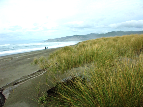
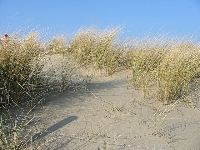
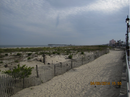
Coastal dunes, often referred to as sand dunes, form where there is a readily available supply of sand-sized sediment and are located landward of the beach in the supratidal zone. The size of the sediment, duration, velocity, and direction of winds in the coastal zone, as well as the size and extent of vegetation, are fundamental properties that govern the size and shapes of dunes in coastal settings. The development and growth of dunes derive from the beach when the wind is blowing in an onshore direction. When the wind is blowing offshore, sediment in the dunes is transported back onto the beach or offshore into open water where it may later be carried back to the beach by waves.
Sand accumulates to create a dune system when the wind carrying the sand encounters an obstacle. Pieces of driftwood, trash, or piles of seaweed can all provide such an obstacle, causing the velocity of the wind to locally decrease, at which point the transport of the sand ceases and it is deposited. Most often, the obstacle that creates large continuous sand dunes is salt-water tolerant vegetation, either beach grasses or shrubs and trees depending upon the climate of the region. Vegetation, therefore, promotes the deposition of sand and acts to stabilize the dune system because of rooting.
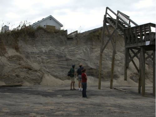
During fair weather conditions, the base of the dunes is not affected by wave energy when a beach is in equilibrium with the prevailing conditions, because the waves dissipate on the beachface. During a storm, when water levels are elevated because of storm surge and large waves are being produced, a dune system may, however, be subjected to breaking waves that can cause erosion and the removal of significant volumes of sediment from the dunes. In extreme situations, dunes can be completely washed over by storm waves, completely flattened, and the sediment that was removed can be carried offshore, alongshore, or farther inland to create a wash over platform.
Overall, the presence of well-established dune systems act as barriers against storm waves and, thus, help to protect infrastructure that is located landward of the dune systems. For this reason, as well as the unique coastal ecosystems that they provide, dunes are very often protected environments. Fences around dunes and walkways above dune vegetation are common features in high traffic areas, and walking through dunes or riding motorized vehicles across them can be met with hefty fines and punishment because of the damage these activities can cause to the dune vegetation.
For more information on beach systems, check out these links:
- Information on different types of sand [9], Geology.com
- Explanation about the littoral system [10], Wikipedia
- Information about the nearshore and beaches [11], University of Puerto Rico, Department of Geology
- Review of beach processes along California, U.S [12]., 4:48 minute video, Keith Meldahl, Professor of Geology and Oceanography, Mira Costa College
- Sand movement in dune systems [13], 5:32 minute video, Simon Haslett, Professor of Physical Geography, University of Wales
- Formation of sand dunes [14] 30-second video, Darron Gedge's Geography Channel
Learning Check Point
Learning Check Point
Please take a few minutes to think about what you just learned then answer the questions below to test your knowledge.