Consequences of Concomitant Reduction
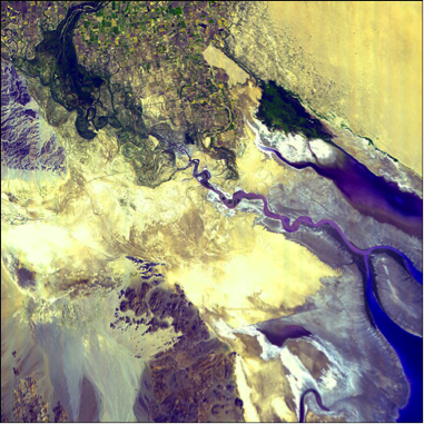
The concomitant reduction in sediment delivery to downstream areas also has several consequences (Figures 7-9). Ultimately the decreased sediment supply to the river mouth translates to net erosion of beaches and loss of land in coastal regions, as natural coastal erosion by currents and subsidence caused by compaction of delta sediments is not offset by delivery of sediment. For example, prior to construction of the Aswan High Dam began in 1960, the annual sediment flux to the Nile Delta was ~100 million tons. This sediment supply was enough to offset erosion and natural subsidence.
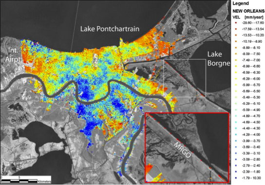
Without continued sediment delivery, subsidence and coastal erosion lead to significant losses of land area (Three Gorges: A “Mega-Dam” and its Impacts), much of which is prized for agriculture or development. Currently, parts of the Nile Delta are subsiding at up to 1 cm/yr. This phenomenon is common to most of the world’s major river systems, including the Mississippi, Colorado, Yangtze, and Indus Rivers (Figure 7). For example, much of New Orleans is subsiding at over a half-centimeter per year, with some areas sinking more than 2.5 cm/yr (Figure 9). The combination of subsidence, coastal erosion, and sea-level rise has led to land loss from the Mississippi Delta of almost 1100 acres per year since the mid-1970s.
The same processes also place these areas at especially high risk for flooding in major storm events. Much of the inundation of the Gulf Coast caused by Hurricane Katrina in 2005 occurred in areas that lie below sea level due to subsidence. The effects of subsidence are compounded by the loss of barrier islands as their sediment supply is not replenished. Further, extraction of groundwater from the subsurface – and in some cases oil and gas - exacerbates land subsidence, and can also lead to saltwater intrusion in coastal aquifers.