
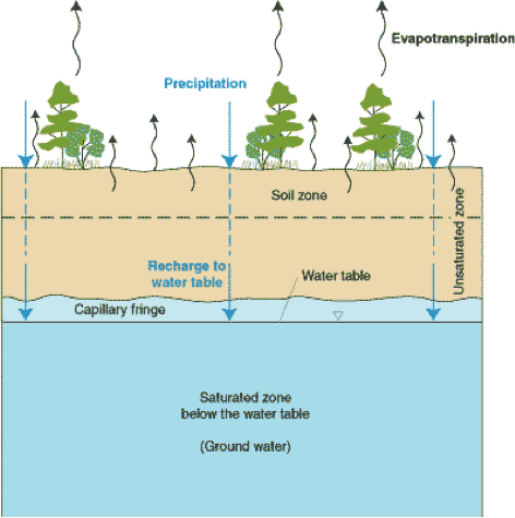
Aquifer Anatomy
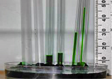
In the simplest sense, you might imagine an aquifer formation that may be covered by a veneer of soil, and which extends downward from a few feet below the surface for several tens or even hundreds of feet (Figure 3). At some depth below the land surface, the interstices between soil or sediment particles, or the fractures in the rock, will be water-filled or saturated. Shallower than that depth, these interstices, or pore spaces, will be filled with air, water vapor, and some liquid water bound to the surfaces of the rock (Figures 3-5). This zone is the unsaturated zone, also known as the “zone of soil moisture” or the vadose zone. The water table marks the top of the ground water system and is formally defined as the depth at which the pressure in the subsurface is equal to the atmospheric pressure. Immediately above the water table, there is a narrow zone of saturation termed the capillary fringe. In this zone, water is wicked upward in pore spaces due to capillary forces. This is analogous to capillary tube experiments you may have seen or performed in physics or chemistry classes in high school; it occurs due to interaction between the polar water molecule and the surfaces of the solids, and is directly related to the fact that water has a surface tension (as you may remember from Module 1!). In the capillary fringe, pores are saturated, but pressures are sub-atmospheric, meaning that the water is under suction as it is pulled or wicked upward. The nomenclature “fringe” reflects the fact that slight variations in grain size lead to variations in the height that water is drawn (again, think to the capillary tube experiment, and effects of different tube sizes) (Figure 5).
Any precipitation or surface water that infiltrates to the water table must percolate through the vadose zone in order to recharge the aquifer. As we will see later in this module infiltration and recharge typically constitute only a small fraction – rarely more than 10% - of precipitation, because most water that falls in events is returned to the atmosphere by transpiration or evaporation, becomes runoff (i.e., if the capacity for infiltration is exceeded by the rate of precipitation), or is bound by soils in the vadose zone.
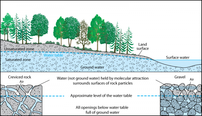
Water (not ground water) held by molecular attraction surrounds surfaces of rock particles. All openings below the water table are full of ground water. The Unsaturated Zone is on the land surface and above the water table which contains the saturated zone, surface water, and ground water.