Ponding the Waters: Impacts of Dams
Ponding the Waters: Impacts of Dams
As we’ve covered in the first part of this module, the need for dams is largely driven by the uneven distribution of precipitation, resulting from river discharge, and thus water supply – in both time and space. Dams control river flows and provide capacitance in the river channel to satisfy demands for continuous water supply (i.e. for irrigation and domestic use, for flood control, and power generation). However, such large-scale alteration of the natural river has wide-ranging impacts both upstream and downstream, where the ecology, geology, hydrology, and human populations have evolved in tandem with undisturbed patterns of variable river discharge. Here we’ll briefly cover some of these impacts, and highlight using examples from well-known case studies including the Three Gorges and Aswan High Dams.
Nutrient Supply to Floodplains
Nutrient Supply to Floodplains
Flooding is a natural process that replenishes soil and nutrients to floodplains. Of course, floodplains are ideal sites for agriculture – they are flat, water is accessible, and – at least prior to modification of the system by levees or dams – the soils are among the most fertile on Earth due to recurring flooding that deposits nutrient-rich fine-grained sediments. Historically, these are the sites of major agricultural and population centers, including the “Fertile Crescent” along the Tigris-Euphrates floodplain (now largely barren due to long-term effects of irrigation-based agriculture and flood prevention), and the Nile Floodplain (see The Nile River and Aswan Dam below). Likewise, most major modern agricultural production is localized to floodplains - including the Central Valley of California, the Susquehanna River Valley, the upper Tigris-Euphrates basin, the Nile Valley, and the floodplains of the Mississippi and Missouri Rivers.
Prevention of flooding through the combination of dams (which control river discharge) and levees (which artificially channelize flow and shunt it downstream so that it cannot spill onto the floodplain) is a strategy to limit the loss of crops and property, and allow development in otherwise flood-prone areas. This approach, while generally effective in limiting short-term losses, affects soil fertility, groundwater systems, and the health of downstream waterways in the longer-term. For example, flood prevention eliminates a major source of recharge to aquifers in valley-fill sediments that lie below the floodplain. Recurring floods also serve to flush salts that accumulate naturally in soils due to evaporation and transpiration (i.e. water is transported to the atmosphere by these processes, but even small amounts of dissolved salts remain in the soil). Reduction or elimination of this flushing can lead to soil salinization, with negative effects on soil fertility.
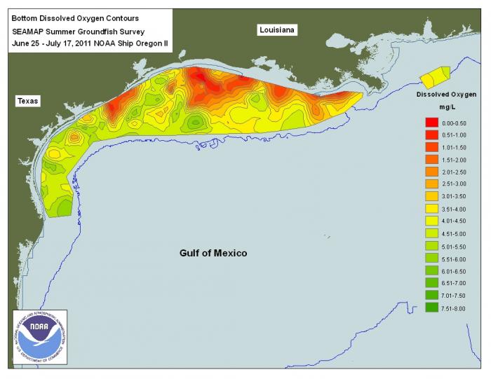
Perhaps most notably, by eliminating or limiting the replenishment of nutrients to the floodplain, imported fertilizer is required to grow crops. Excess fertilizer application, in turn, leads to runoff enriched in Nitrogen and Phosphates that affects aquatic species and can cause eutrophication of lakes and estuaries downstream. This is a longstanding problem that leads to algal blooms at river mouths, consumption of Oxygen by organic matter (dead algae), and ultimately to “dead zones” in these regions that affect fisheries (Figure 2).
Learning Checkpoint
1. Why are floodplains historically ideal for agriculture? List three reasons.
ANSWER: Nutrient supply, soil replenishment, water supply, typically flat. Could also note that rivers provide transport pathway for produced goods.
2. What is the main negative effect of eliminating the replenishment of nutrients to floodplains on ecosystems and river health downstream?
ANSWER: It leads to the addition of fertilizers and nutrients to the land, which in turn runs off to the river and ultimately the ocean. This leads to algal blooms that extract dissolved oxygen from the water, and cause hypoxic, or “dead” zones that impact fisheries and ecosystem health.
The Nile River and Aswan Dam
The Nile River and Aswan Dam
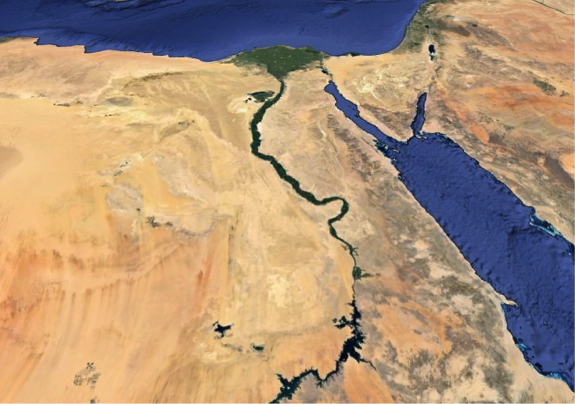
Large rivers are difficult to control. The Nile River, so important to Egypt's populace, is no exception. But since the late 1960s, the Nile River has been under the control of humans because of the construction of the Aswan High Dam. Part of the rationale for this dam was to manage the natural cycles of flood and drought to produce dependable water supplies for farming and other uses. The consequences of cyclic climate variations on a decadal scale were buffered by the large storage capacity of the Nile Valley behind the High Dam, which is nearly six trillion cubic feet (157 km3) of water! This is about four times the amount of water stored behind Hoover Dam (USA, Lake Mead) and Three Gorges Dam (China) (Chao et al., 2008). In addition, the Aswan High Dam initially produced a significant amount of electrical power (about 50%, now less than 15% of Egypt's needs) that allowed electrification of "rural" Egypt.
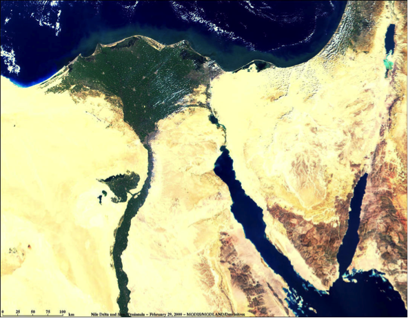
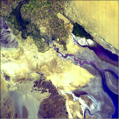
Figure 3 shows the narrow Nile River Valley slicing northward through the Egyptian desert. The narrow green band of the Nile River Valley represents farmland irrigated by waters of the Nile River. Prior to the completion of Aswan High Dam, the Nile River would flood its valley annually during the rainy season in its higher altitude headwaters (Ethiopia, Sudan, Kenya, Uganda), bringing nutrient-rich silt to fields and renewing fertility. In addition, a substantial volume of sediment was carried down the Nile River Channel to its large delta, building out the delta into the Mediterranean Sea, providing additional fertile land for farming. This no longer happens because the Aswan High Dam effectively (an unintended consequence) traps sediment carried from the highlands behind it. Now, the delta region, which subsides naturally as the result of compaction of sediment (newly deposited sediments have water contents of 70% or more that are reduced by compaction by overburden), is diminishing in size because rates of coastal erosion exceed supply of sediment. Currently, almost 1/3 of the Nile Delta’s land area sits within a meter of sea level. Subsidence rates vary across the delta, but in some areas, the land surface is sinking as fast as 1 cm/yr. Control of the Nile’s flow has also lead to water quality problems. Because once-regular floods no longer flush salts, sewage, fertilizers, and waste from the delta, surface waters are polluted and those living near the Mediterranean coast increasingly rely on groundwater to meet demand for drinking water and domestic use. Extraction of groundwater, coupled with land subsidence, has led to saltwater intrusion in the aquifer as far as 30 km inland.
There have been other unintended consequences of the Aswan High Dam including the spread of disease (Schistosomiasis), a decrease in water quality and increase in algal blooms resulting from fertilization of farm fields and irrigation runoff, flooding of historical sites, and displacement of people from the regions flooded by the reservoir.
Sediment Trapping
Sediment Trapping
Because large reservoirs behind major dams are areas where water flow velocity is slowed (also often called “slackwater”), sediments are deposited where rivers enter the water body (Figure 5). Sedimentation in reservoirs behind dams has several consequences. Sediment deposition reduces reservoir water storage capacity and therefore limits the useful lifetime of the dam for flood control, water supply, and hydropower generation. Recent detailed studies of storage capacity and sedimentation rates for reservoirs in the U.S. suggest that average annual storage losses range from less than 0.5% to more than 2% (see supplemental reading: Graf et al., 2010; “Sedimentation and sustainability of western American Reservoirs, Water Resources Research”). The highest rates of storage loss are occurring in the American West, and the lowest in the Northeast.
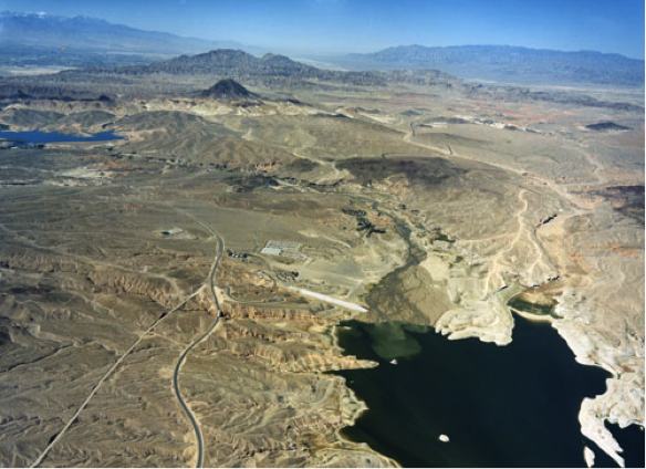
For example, almost 20 million tons of sediment are deposited annually in reservoirs along the Mississippi River (UNESCO, 2011). China’s Three Gorges Dam alone (one of several along the Yangtze River) traps 34 million tons of sediment per year, or 31% of the river’s sediment load (Hu et al., 2009). Globally, the amount of sediment trapped behind dams is estimated to be 73 km3 (Syvitsky & Kettner, 2011). This sediment accumulation slowly reduces reservoir capacity behind dams and is one factor that limits their useful life expectancy. Recent studies of sediment accumulation suggest that the life expectancy of Lake Powell is ~300-700 yr, and that of the Three Gorges Reservoir in China is ~150 yr.
The concomitant reduction in sediment delivery to downstream areas also has several consequences (Figures 5-6). Ultimately the decreased sediment supply to the river mouth translates to net erosion of beaches and loss of land in coastal regions, as natural coastal erosion by currents and subsidence caused by compaction of delta sediments is not offset by delivery of sediment. For example, prior to construction of the Aswan High Dam began in 1960, the annual sediment flux to the Nile Delta was ~100 million tons. This sediment supply was enough to offset erosion and natural subsidence.
Consequences of Concomitant Reduction
Consequences of Concomitant Reduction
The concomitant reduction in sediment delivery to downstream areas also has several consequences (Figures 7-9). Ultimately the decreased sediment supply to the river mouth translates to net erosion of beaches and loss of land in coastal regions, as natural coastal erosion by currents and subsidence caused by compaction of delta sediments is not offset by delivery of sediment. For example, prior to construction of the Aswan High Dam began in 1960, the annual sediment flux to the Nile Delta was ~100 million tons. This sediment supply was enough to offset erosion and natural subsidence.
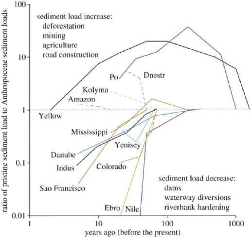
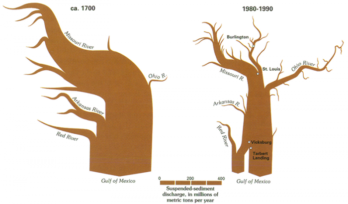
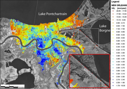
Without continued sediment delivery, subsidence and coastal erosion lead to significant losses of land area (Three Gorges: A “Mega-Dam” and its Impacts), much of which is prized for agriculture or development. Currently, parts of the Nile Delta are subsiding at up to 1 cm/yr. This phenomenon is common to most of the world’s major river systems, including the Mississippi, Colorado, Yangtze, and Indus Rivers (Figure 7). For example, much of New Orleans is subsiding at over a half-centimeter per year, with some areas sinking more than 2.5 cm/yr (Figure 9). The combination of subsidence, coastal erosion, and sea-level rise has led to land loss from the Mississippi Delta of almost 1100 acres per year since the mid-1970s.
The same processes also place these areas at especially high risk for flooding in major storm events. Much of the inundation of the Gulf Coast caused by Hurricane Katrina in 2005 occurred in areas that lie below sea level due to subsidence. The effects of subsidence are compounded by the loss of barrier islands as their sediment supply is not replenished. Further, extraction of groundwater from the subsurface – and in some cases oil and gas - exacerbates land subsidence, and can also lead to saltwater intrusion in coastal aquifers.
Consequences of Release of Water
Consequences of Release of Water
Release of water from the downstream side of reservoirs at dams affects the ecology of the river downstream because there is little or no entrained sediment to replenish alluvial deposits along the river, and, in fact, the now sediment-starved river is more likely to erode existing bars, beaches, and riverbeds. In many cases, the clear water released from dams can erode fine-grained sediments (silts and clays) from river banks and bars, leaving behind the coarser sand and gravel deposits that would require higher flow velocities to mobilize (as we covered in Module 3…remember?). Increased scouring can also lead to destabilization and landsliding along the river banks.
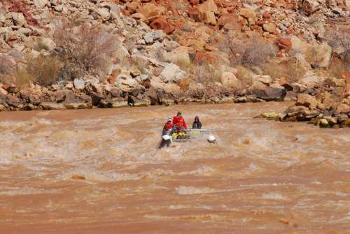
Erosion of sandbars and beaches poses a threat to native fish species that depend on sheltered waters for spawning or their fry. For example, the population of the humpback chub, a fish species native to the Colorado River system, has decreased by an estimated 75% since 1982. The chub was uniquely adapted to thrive in the sediment-laden, low-visibility and naturally turbulent waters of the Colorado River. Since the construction of Glen Canyon Dam, the clear, colder, and more stable flow has favored non-native predatory species like brown and rainbow trout.
Deposition and storage of sediments behind dams also lead to the buildup of organic material and nutrients adsorbed to sediment grains or trapped in pore spaces that will be released if the dam is decommissioned. As discussed in the next part of this module (“Bringing Down the Dams”), if or when dams are decommissioned, many years’ worth of sediment, nutrients, and carbon must be managed. Release of the stored sediment can lead to:
- inundation of the river system with suspended sediment that increases water turbidity
- introduction of nutrients to the river mouth that can lead to eutrophication and dead zones
- the potential release of toxins, including metals and volatile organic compounds adsorbed to fine sediment, to downstream areas
Recent controlled water releases have been conducted to explore the possibility of delta and downstream habitat renewal. In 1996, a seven-day-long experimental release of 1290 m3/s (that’s about 20 million gallons per minute) from Glen Canyon Dam was conducted to evaluate the prospects for the restoration of stream habitat through the rebuilding of sandbars and beaches. The experiment yielded mixed results – most notably that sand was initially deposited on bars and beaches, but only during the first couple of days of the release. There was not enough sediment load in the released water to sustain deposition, partly because the experiment was not synchronized with the natural seasonal sediment flux from upstream tributaries; as a result, existing bars were eroded and remobilized in the late stages of the controlled flood. In March 2014, a “pulse flow” of 105,000 acre-feet (about 1% of the River’s annual discharge) lasting until mid-May was released from Morelos Dam to bring water to the Colorado River Delta through a joint US-Mexico initiative. You can listen to a brief news story about the experiment: Well, I'll be Un-Dammed: Colorado River (Briefly) Reached The Sea [4]. The pulse flow was designed to mimic natural spring floods that disperse seeds, nourish the delta, and provide habitat for waterfowl. These experiments suggest that partial restoration may be possible, but will likely require a better understanding of the dynamics of stream habitats and sediment delivery and transport processes.
Other Impacts
Other Impacts
In this section, we will consider other impacts of dams.
Pollution
Pollution
In addition to the increased nutrient concentrations from agricultural return flow downstream of dams, the reduction in flow velocity in slackwater behind dams leads to reduced flushing of pollutants that enter the river. In areas subject to high rates of municipal or industrial wastewater discharge, or to agricultural runoff, this can lead to significant impairment of water quality in the reservoir itself, and in upstream tributaries (for example, see Three Gorges: A “Mega-Dam” and its Impacts). High nutrient fluxes can also lead to eutrophication of the reservoir. Additionally, the increased surface area of reservoirs leads to large evaporative losses and subsequent increases in water salinity, especially in arid and semi-arid climates.
Fish Spawning and Migration
Fish Spawning and Migration
As noted previously, dams have wide-ranging effects on downstream habitat through changes they cause to water turbidity and sedimentation and erosion patterns. These changes threaten certain species that have evolved to thrive in the natural system – like the humpback chub – through a combination of decreased or degraded breeding habitat and increased predation by non-native species. Additionally, because water released from dams through intakes flows from the deep part of the reservoir, it is commonly colder than the natural river flow – and its temperature is less variable than in the river’s natural state. For example, prior to construction of the Glen Canyon Dam, water temperature in the Colorado River varied from ~0 to 27° C over the course of the year; water discharged from the dam now averages ~8°C and varies little seasonally. The changes in water temperature and its variability impact some fish species, which rely on temperature cues to trigger key lifecycle events. The lower oxygen levels in waters released from storage behind dams also impact fish downstream.
Finally, dams present physical barriers to catadromous and anadromous fish species (those that spawn in saltwater and live in freshwater, and vice-versa, respectively). These fish migrate either upriver from the ocean (anadromous), or downriver to the ocean (catadromous) to spawn. After hatching, the young fish migrate in the opposite direction. Of these, perhaps the best known is the salmon, which migrates up-river to spawn, commonly over hundreds or thousands of km – for example, although greatly reduced due to major dams along the Columbia and Snake Rivers, Chinook salmon runs commonly extend from the Pacific Ocean all the way to Idaho! Structures designed to allow fish to navigate dams, such as fish ladders, are one solution, but they still present a barrier that reduces the likelihood of safe passage, and thus fish numbers.
Diseases – A Tropical Malady
Diseases – A Tropical Malady
The large reservoirs impounded by dams provide breeding grounds for some water-borne diseases and parasites, especially in tropical climates. Among the most prevalent of these is schistosomiasis, a disease caused by parasitic worms. The parasite is spread by freshwater snails, and has come to be known as the “disease of hydroelectric dams”. It infects an estimated 200 million people per year (with 200,000 fatalities), primarily in Asia, Africa, and South America. Through the expansion of habitat for the disease vector by large slackwater reservoirs, the incidence of this and other diseases is greatly increased. For example, in the Yangtze River Basin, the incidence of schistosomiasis is near 5%, versus less than 1% in less or undeveloped areas.
Dams and major irrigation projects also provide expanded breeding habitat for insects (mosquitos) that serve as vectors of Dengue fever, malaria, and West Nile virus, among others. The World Health Organization (WHO) estimates that malaria cases in villages near the Bargi reservoir in India increased more than twofold following the dam’s construction, and up to four-fold in villages closest to the dam itself. Likewise, malaria incidence increased by seven times in proximal Ethiopian villages following the construction of small dams on the Tigray River. A similar increased incidence of West Nile virus has been documented as a result of increased mosquito breeding area in many parts of the world, including the Midwestern U.S., California, and Oregon.
Earthquakes and Structural Failures
Earthquakes and Structural Failures
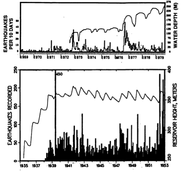
Impoundment of water behind major dams changes the distribution of stress in the Earth’s crust, and in combination with downward percolation of impounded water, can trigger seismicity. For the most part, this phenomenon is restricted to increased numbers of small (magnitude <3.5) earthquakes triggered by the increased load of millions of m3 of water, associated warping – or flexure – of the crust, and diffusion of water pressure from the reservoir along fractures and fault lines (Figure 10). Although hotly debated, reservoir-induced seismicity has even been invoked as a possible mechanism for the devastating 2008 magnitude 7.9 Wenchuan earthquake that killed an estimated 80,000 people (see one news article discussing this issue here [5]). The reservoir impounded behind the 156 m-tall Zipingpu Dam lies above the Beichuan- Yinxiu fault, which extends to the Northeast to the earthquake hypocenter, located ~50 km away.
Although remote, there is also a potential risk of dam failure to life and property downstream. In some cases, the causes of such failures are not known with much certainty. For example, the collapse of the St. Francis Dam Northeast of Los Angeles in 1928 resulted in the catastrophic release of over 12 billion gallons of water. The flood wave, which was over 140 feet high, killed an estimated 600 people and scoured the valley below, transporting fragments of the dam as large as 10,000 tons for almost a mile downstream. In other cases, upstream flooding or inadequate ability to release water and relieve pressure on the dam are the culprit, as in the famous collapse of the South Fork dam and resulting 1889 Johnstown PA flood that killed over 2000 people and triggered changes to liability laws in the U.S. In 1986, a similar disaster at the Glen Canyon Dam was narrowly avoided.
Politics and Control of Flow Across Borders
Politics and Control of Flow Across Borders
Rivers are not restricted by state and national borders, whereas dams are rarely constructed or managed by collaboration between governments. As a result, alteration, interruption, and control of river discharge by dams naturally leads to political and legal conflict. In the case of the Colorado River, which we will cover in more detail in Module 8 (Cities in Peril), the allocation of water between states within the drainage basin is governed by the 1922 Colorado River Compact. Allocation of water between the U.S. and Mexico is governed by an international treaty established in 1944 and recently revised in 2012. Even though well established, the water allocation of the Colorado, and its fairness are widely debated. The compact is also the focus of lawsuits over water rights for Native American reservations, which were not explicitly included in the original agreement. Court battles have also arisen over other river flows in recent years (for example in Florida and Georgia, and along the San Joaquin and Sacramento Rivers) pitting access for communities or farmers against minimum limits on flow required to support endangered species.
Globally, other rivers and dams are the source of equal – or more – controversy. As one example, at the 1992 opening ceremonies for the Atatürk Dam on the Euphrates River in Turkey, the president of Turkey is reported to have said, "Neither Syria nor Iraq can lay claim to Turkey’s rivers any more than Ankara could claim their oil. This is a matter of sovereignty. We have a right to do anything we like. The water resources are Turkey’s, the oil resources are theirs. We don’t say we share their oil resources, and they can’t say they share our water resources." The conflict over waters of the Tigris-Euphrates continues (you can listen to a story about this dispute here [6]). Dams and control of river flows in the headwaters of the river system, and subsequent impacts on water access to supply populations with drinking water, to grow food, and support industry in the downstream nations of Iraq and Syria, are at the heart of the dispute. Similar tensions are now arising along the Mekong River between China (upstream) and downstream neighboring countries of Myanmar, Thailand, Laos, Cambodia, and Vietnam that rely on the river.
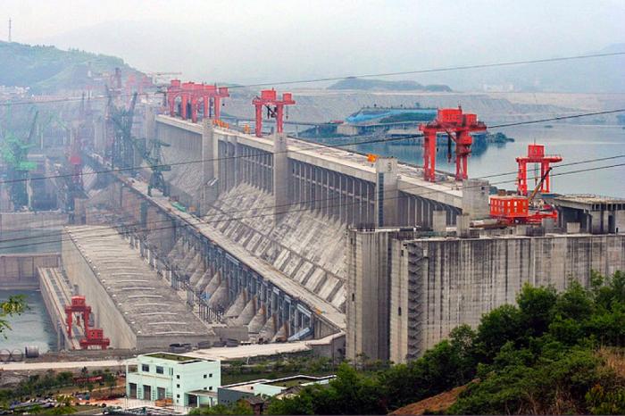
Three Gorges: A “Mega-Dam” and Its Impacts
Three Gorges: A “Mega-Dam” and Its Impacts
The Yangtze River is the longest river in Asia and is the world’s 3rd longest (only the Nile and Amazon are longer). It flows for ~6300 km from its headwaters on the Tibetan Plateau to its delta at Shanghai, where it discharges to the East China Sea. The Yangtze watershed encompasses approximately 1/5 of China’s land area. The river serves the water demand of millions of people and the delta alone supports almost 20% of China’s GDP. However, the Yangtze is also notorious for its frequent and devastating floods. Floods in the twentieth century alone led to the loss of an estimated 300,000 lives, including 145,000 drowning deaths in a 1931 flood, and 30,000 deaths in 1954 from flooding and diseases that followed. In addition to loss of life, these floods inundated hundreds of thousands of acres of productive farmland and caused billions of dollars of damage.
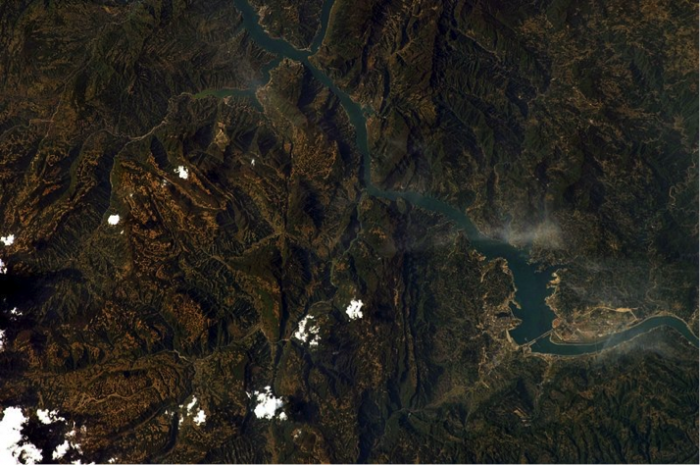
To protect over 15 million people in Shanghai and the lower Yangtze floodplains, and control flooding of almost 15,000 square km of land, construction of the Three Gorges Dam began in 1994. The dam, constructed at a cost of between ~$28-60 billion dollars (exact cost is not known because the project has been funded by a combination of government subsidy and private investment), is nearly 200 m high, spans more than 2 km across the river, and was engineered to withstand a magnitude 6.0 earthquake (Figure 11). The long, narrow Three Gorges Reservoir extends ~600 km upstream and has a capacity of almost 40 billion m3 of water (equivalent to about 32 million acre-feet) (Figure 12). At the time of construction, the dam was the largest hydroelectric power plant on Earth, with a generating capacity of over 20,000 megawatts - more than 20 times that of Hoover Dam, equivalent to 18 nuclear power plants, and enough to supply almost 10% of China’s power demand. According to the Chinese government, if this amount of electricity were generated using coal-fired power plants instead, 100 million tons of additional carbon dioxide would be released into the atmosphere. The dam also increases the navigability of the Yangtze, allowing large freighters to transport goods far into China’s interior.
Despite the obvious benefits of the dam for the economy and generation of renewable energy, the Three Gorges Dam has been mired in controversy since its inception. Concerns about the dam include an array of environmental impacts, the forced relocation of over a million residents, initiation of large landslides and earthquakes by the rising reservoir, and flooding of important historic and cultural sites in the gorge upstream of the dam. The chief environmental issues center on impacts to river ecology and already threatened species increased chances for waterborne diseases, and water quality degradation associated with the slowed flow of the river in the backwaters of the dam, in tributaries, and in downstream regions. Indeed, in the wake of pollution concerns, during construction, an additional $4.8 billion was budgeted for new treatment plants and garbage disposal sites along the river’s upstream reaches.