Global Wind
Global Wind
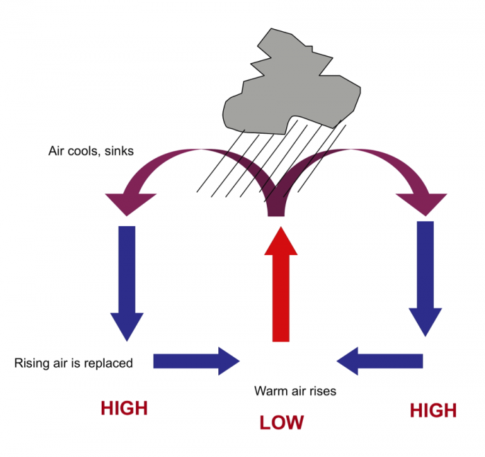
As this warm air rises due to its lower density, it cools. Once it cools past the dewpoint, condensation occurs and clouds form. With continued rise and cooling, the air cannot hold the moisture and precipitation falls.
In response to that rising air, surface air must flow in to fill the vacated space. The rising air results in a low-pressure center. This is why when you hear about low pressure in the forecast, is typically associated with rising air masses and therefore with crummy weather. The air rushing in toward the equator defines the trade winds. These winds converge on the equator but blow to the West because of Earth’s rotation. This rotational effect is known as the Coriolis effect. We won’t get into that in detail here, but if you are interested, check out the video below.
Video: The Coriolis Effect (03:05)
NARRATOR: If you've ever watched the news during a hurricane or wintertime nor'easter, you've probably noticed that big storms spin over time as they travel. In the Northern Hemisphere, they spin counterclockwise. But if you were watching a storm in the Southern Hemisphere, you'd see it spinning clockwise.
Why do storms spin in different directions depending on their location? And why do they spin in the first place? A storm's rotation is due to something called the Coriolis effect, which is a phenomenon that causes fluids like water and air to curve as they travel across or above the Earth's surface.
Here's the basic idea: Earth is constantly spinning around its axis from west to east. But because Earth is a sphere, and wider in the middle, points at the equator are actually spinning faster around the axis than points near the poles.
So imagine you were standing in Texas and had a magic paper airplane that could travel hundreds of miles. If you threw your airplane directly northward, you might think that it would land straight north, maybe somewhere in Nebraska.
But Texas is actually spinning around Earth's axis faster than Nebraska is because it's closer to the equator. That means that the paper airplane is spinning faster as well, and when you throw it, that spinning momentum is conserved. So, if you throw your paper airplane in a straight line toward the north, it would land somewhere to the right of Nebraska—maybe in Delaware. So, from your point of view in Texas, the plane would have taken a curved path to the right.
The opposite would happen in the Southern Hemisphere. An object traveling from the equator to the south would get deflected to the left.
So, what does this have to do with hurricanes spinning? Well, at the center of every hurricane is an area of very low pressure. As a result, the high-pressure air surrounding the center or "eye" of a storm is constantly rushing toward the low-pressure void in the middle.
But because of the Coriolis effect, the air rushing toward the center is deflected off course. In the Northern Hemisphere, the volumes of air on all sides of the eye keep getting tugged slightly to the right. The air keeps trying to make its way to the middle and keeps getting deflected, causing the entire system to spin in a counterclockwise direction.
In the Southern Hemisphere, where the Coriolis effect pulls air to the left, the opposite happens: storms spin around the eye in a clockwise manner.
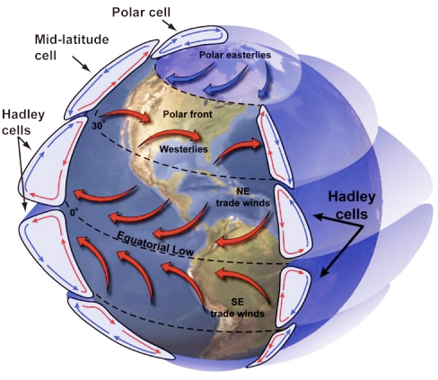
These flows drive convection cells, with dimensions that are controlled by the viscosity and density of air, and by the thickness of the atmosphere. The air that rose from the equator flows North and South at the top of the cell and eventually descends at around 30° N or S latitude. As the cool, now dry air descends it warms. Sound familiar?
Just as occurs when air descends on the leeward side of mountain ranges and causes rain shadows, the amount of water that the descending and warming air could hold increases. But there is no additional moisture to be found, so the actual amount of water vapor in the air mass remains more-or-less fixed. These descending limbs of the Hadley cells form high-pressure centers and would be regions where persistent dry conditions should prevail – leading to the Earth’s desert belts that include the Gobi, Sahara, Arabian, and the Australian Outback (not just a steakhouse!).
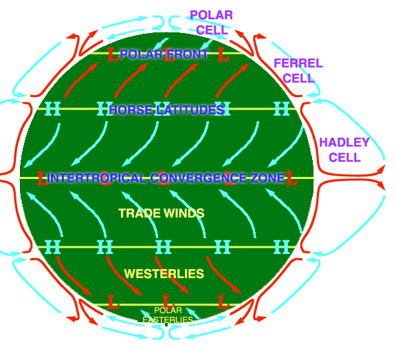
The equatorial convection cells are known as Hadley Cells. There are two more in each hemisphere, also driven by the uneven distribution of incoming solar radiation density; these are Farrell and Polar cells. Check out the diagram of this process below.
Global Wind Explained
Global Wind Explained
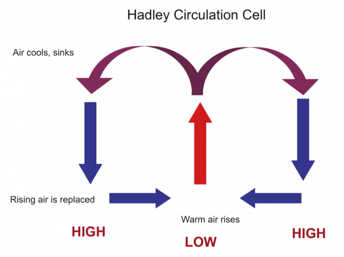
The illustration below portrays the global wind belts, three in each hemisphere. Note that the U.S. lies primarily in the Westerly Wind Belt with prevailing winds from the west. Each of these wind belts represents a "cell" that circulates air through the atmosphere from the surface to high altitudes and back again. The cells on either side of the Equator are called Hadley cells and give rise to the Trade Winds at Earth's surface. How do we explain this pattern of global winds and how does it influence precipitation?
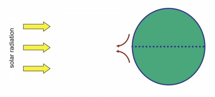
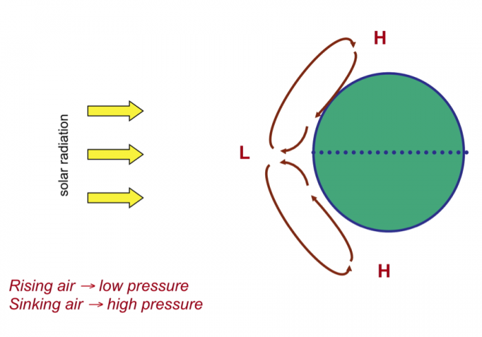
We'll start at Earth's equator, where solar radiation is the highest year around. Air near the equator is warmed and rises because it is less dense (mass/unit volume) than the air around it as shown in Figure 21 below.
The rising air creates a circulation cell, called a Hadley Cell, in which the air rises and cools at high altitudes moves outward (towards the poles) and, eventually, descends back to the surface. The continual heating and rise of air at the equator create low pressure there, which causes air to move (wind) towards the equator to take the place of the air that rises. On the other hand, sinking air creates high pressure at the surface where it descends. A gradient of pressure (high to low) is formed that causes air to flow away from the high and towards the low pressure at the surface.
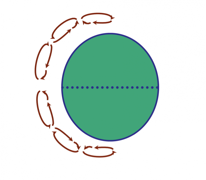
The Earth would have two large Hadley cells if it did not rotate. But, because it does rotate, the rotation of the Earth leads to the Coriolis effect. You should view the short video on this so-called "effect" or "force." (The Coriolis Effect [2]). Without going into detail as to why rotation creates this apparent force, the Coriolis effect causes winds (and all moving objects) to be deflected:
- to the right in the Northern Hemisphere
- to the left in the Southern Hemisphere
The Coriolis effect causes winds to deflect as they travel within circulation cells and results in the two large hypothetical Hadley cells breaking into six smaller cells, which looks something like the diagram below (and the first figure in this series).
Ok, so, we now have some idea about the origin of global wind systems that result from pressure gradients at Earth's surface. How does this produce precipitation, and where? Precipitation occurs where moisture-laden air rises, either by heating at the equator or by running up and over a more dense air mass. As the rising air cools its capacity to hold water decreases (relative humidity increases) and, at some point, saturation with respect to water vapor is reached. Then, condensation--clouds and rain!
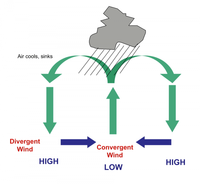
The diagrams above and below portray just the Hadley cell circulation, that is driven by heating in the equatorial region. On the surface, wind moves away from high pressure (High) and toward low pressure (Low). Convergence occurs near the equator (winds blow in towards one another) and Divergence occurs under the descending air that forms high-pressure belts. The final figure (Figure 26) shows all six cells diagrammatically, along with the pressure variations at the surface of the Earth and zones of typical wet and dry belts. Note particularly the dry belts near 30 degrees North and South.
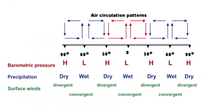
| Latitude | Barometric Pressure | Precipitation | Surface winds |
|---|---|---|---|
| 90° | High | Dry | Divergent |
| 60° | Low | Wet | Convergent |
| 30° | High | Dry | Divergent |
| 0° | Low | Wet | Convergent |