Sediment Trapping
Sediment Trapping
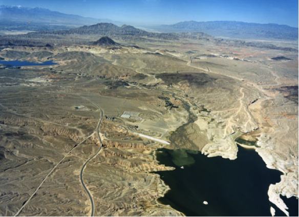
Because large reservoirs behind major dams are areas where water flow velocity is slowed (also often called “slackwater”), sediments are deposited where rivers enter the water body (Figure 5). Sedimentation in reservoirs behind dams has several consequences. Sediment deposition reduces reservoir water storage capacity and therefore limits the useful lifetime of the dam for flood control, water supply, and hydropower generation. Recent detailed studies of storage capacity and sedimentation rates for reservoirs in the U.S. suggest that average annual storage losses range from less than 0.5% to more than 2% (see supplemental reading: Graf et al., 2010; “Sedimentation and sustainability of western American Reservoirs, Water Resources Research”). The highest rates of storage loss are occurring in the American West, and the lowest in the Northeast.
For example, almost 20 million tons of sediment are deposited annually in reservoirs along the Mississippi River (UNESCO, 2011). China’s Three Gorges Dam alone (one of several along the Yangtze River) traps 34 million tons of sediment per year, or 31% of the river’s sediment load (Hu et al., 2009). Globally, the amount of sediment trapped behind dams is estimated to be 73 km3 (Syvitsky & Kettner, 2011). This sediment accumulation slowly reduces reservoir capacity behind dams and is one factor that limits their useful life expectancy. Recent studies of sediment accumulation suggest that the life expectancy of Lake Powell is ~300-700 yr, and that of the Three Gorges Reservoir in China is ~150 yr.
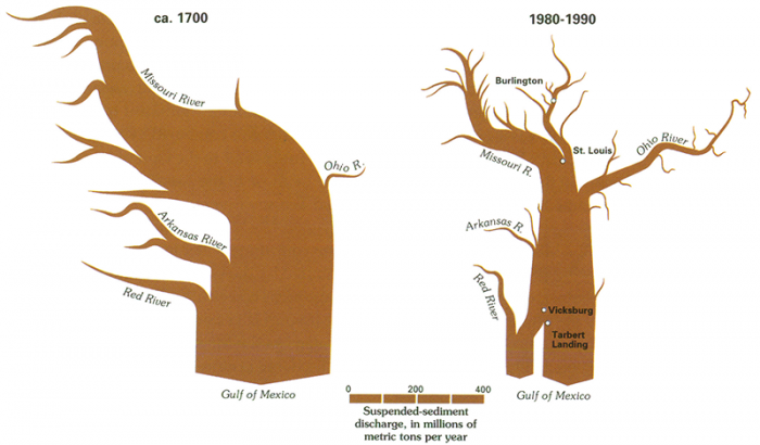
The concomitant reduction in sediment delivery to downstream areas also has several consequences (Figures 5-6). Ultimately the decreased sediment supply to the river mouth translates to net erosion of beaches and loss of land in coastal regions, as natural coastal erosion by currents and subsidence caused by compaction of delta sediments is not offset by delivery of sediment. For example, prior to construction of the Aswan High Dam began in 1960, the annual sediment flux to the Nile Delta was ~100 million tons. This sediment supply was enough to offset erosion and natural subsidence.
Consequences of Concomitant Reduction
Consequences of Concomitant Reduction
The concomitant reduction in sediment delivery to downstream areas also has several consequences (Figures 7-9). Ultimately the decreased sediment supply to the river mouth translates to net erosion of beaches and loss of land in coastal regions, as natural coastal erosion by currents and subsidence caused by compaction of delta sediments is not offset by delivery of sediment. For example, prior to construction of the Aswan High Dam began in 1960, the annual sediment flux to the Nile Delta was ~100 million tons. This sediment supply was enough to offset erosion and natural subsidence.
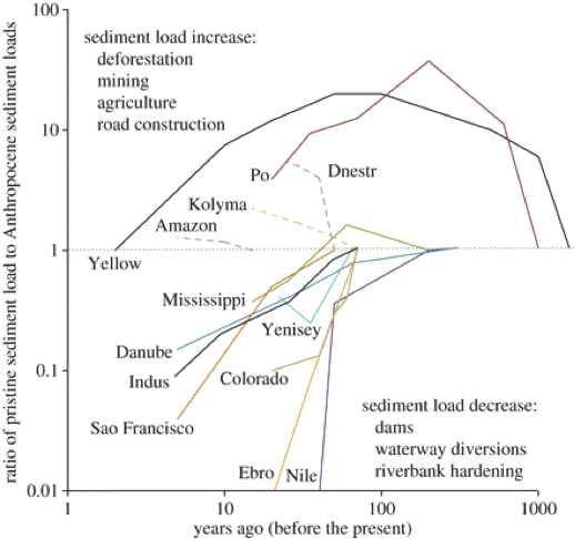
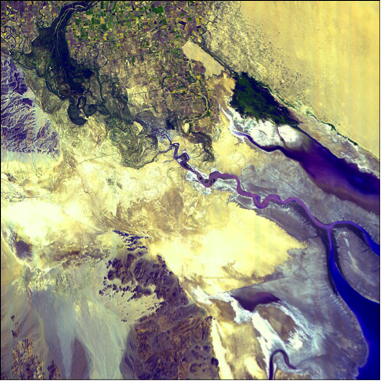
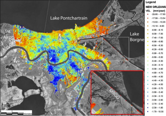
Without continued sediment delivery, subsidence and coastal erosion lead to significant losses of land area (Three Gorges: A “Mega-Dam” and its Impacts), much of which is prized for agriculture or development. Currently, parts of the Nile Delta are subsiding at up to 1 cm/yr. This phenomenon is common to most of the world’s major river systems, including the Mississippi, Colorado, Yangtze, and Indus Rivers (Figure 7). For example, much of New Orleans is subsiding at over a half-centimeter per year, with some areas sinking more than 2.5 cm/yr (Figure 9). The combination of subsidence, coastal erosion, and sea-level rise has led to land loss from the Mississippi Delta of almost 1100 acres per year since the mid-1970s.
The same processes also place these areas at especially high risk for flooding in major storm events. Much of the inundation of the Gulf Coast caused by Hurricane Katrina in 2005 occurred in areas that lie below sea level due to subsidence. The effects of subsidence are compounded by the loss of barrier islands as their sediment supply is not replenished. Further, extraction of groundwater from the subsurface – and in some cases oil and gas - exacerbates land subsidence, and can also lead to saltwater intrusion in coastal aquifers.
Consequences of Release of Water
Consequences of Release of Water
Release of water from the downstream side of reservoirs at dams affects the ecology of the river downstream because there is little or no entrained sediment to replenish alluvial deposits along the river, and, in fact, the now sediment-starved river is more likely to erode existing bars, beaches, and riverbeds. In many cases, the clear water released from dams can erode fine-grained sediments (silts and clays) from river banks and bars, leaving behind the coarser sand and gravel deposits that would require higher flow velocities to mobilize (as we covered in Module 3…remember?). Increased scouring can also lead to destabilization and landsliding along the river banks.
Erosion of sandbars and beaches poses a threat to native fish species that depend on sheltered waters for spawning or their fry. For example, the population of the humpback chub, a fish species native to the Colorado River system, has decreased by an estimated 75% since 1982. The chub was uniquely adapted to thrive in the sediment-laden, low-visibility and naturally turbulent waters of the Colorado River. Since the construction of Glen Canyon Dam, the clear, colder, and more stable flow has favored non-native predatory species like brown and rainbow trout.
Deposition and storage of sediments behind dams also lead to the buildup of organic material and nutrients adsorbed to sediment grains or trapped in pore spaces that will be released if the dam is decommissioned. As discussed in the next part of this module (“Bringing Down the Dams”), if or when dams are decommissioned, many years’ worth of sediment, nutrients, and carbon must be managed. Release of the stored sediment can lead to:
- inundation of the river system with suspended sediment that increases water turbidity
- introduction of nutrients to the river mouth that can lead to eutrophication and dead zones
- the potential release of toxins, including metals and volatile organic compounds adsorbed to fine sediment, to downstream areas
Recent controlled water releases have been conducted to explore the possibility of delta and downstream habitat renewal. In 1996, a seven-day-long experimental release of 1290 m3/s (that’s about 20 million gallons per minute) from Glen Canyon Dam was conducted to evaluate the prospects for the restoration of stream habitat through the rebuilding of sandbars and beaches. The experiment yielded mixed results – most notably that sand was initially deposited on bars and beaches, but only during the first couple of days of the release. There was not enough sediment load in the released water to sustain deposition, partly because the experiment was not synchronized with the natural seasonal sediment flux from upstream tributaries; as a result, existing bars were eroded and remobilized in the late stages of the controlled flood. In March 2014, a “pulse flow” of 105,000 acre-feet (about 1% of the River’s annual discharge) lasting until mid-May was released from Morelos Dam to bring water to the Colorado River Delta through a joint US-Mexico initiative. You can listen to a brief news story about the experiment: Well, I'll be Un-Dammed: Colorado River (Briefly) Reached The Sea [4]. The pulse flow was designed to mimic natural spring floods that disperse seeds, nourish the delta, and provide habitat for waterfowl. These experiments suggest that partial restoration may be possible, but will likely require a better understanding of the dynamics of stream habitats and sediment delivery and transport processes.