Importance of Fractures
Importance of Fractures
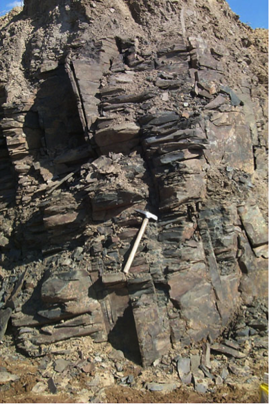
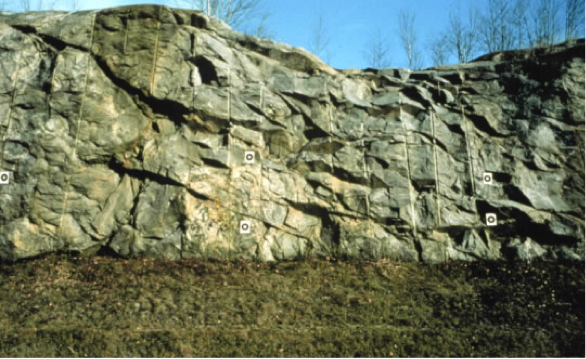
Fractured aquifers are one important and widely used class of aquifer because they are commonly both highly permeable and rapidly recharged. For example, groundwater recharge to the limestone aquifer beneath Nittany Valley in the Spring Creek watershed is around 30-45% of the annual precipitation (in comparison to typical recharge of <10% of precipitation). Fractured aquifers are permeable despite their overall low porosity (usually <5%) because natural fractures usually form in consistent orientations and are well connected in networks over hundreds of meters to tens of kilometers or more (Figures 15-16). The preferred orientation of major fractures leads to anisotropy in permeability, in which the aquifer may be more permeable parallel to the dominant fracture directions than in other orientations.
The rapid flow rates and direct pathways for recharge from the land surface also lead to concerns specific to fractured aquifers. In the absence of confining layers or thick soils, rapid recharge along fractures that extend to or nearly to the land surface increase vulnerability of contamination by surface activity, including fertilization of fields, pesticide application, or spills. Direct connections between surface water bodies and groundwater through major fracture systems also increase the potential for water-borne pathogens to enter the groundwater system, especially during periods of high flow or if confining layers along stream beds are breached. Compounding this risk, if contamination does occur, flow along fracture networks can be very rapid and the direction and rates of contaminant transport difficult to predict - unless the fracture network in the subsurface is extraordinarily well known, which is rarely the case. Because of their potential for contamination, fractured aquifers are a subject of highly active research, including dedicated large-scale field programs (e.g., check out the U.S. Geological Survey’s Mirror Lake project [1]).
. At some depth below the land surface, the interstices between soil or sediment particles, or the fractures in the rock, will be water-filled or saturated. Shallower than that depth, these interstices, or pore spaces, will be filled with air, water vapor, and some liquid water bound to the surfaces of the rock (Figures 3-5). This zone is the unsaturated zone, also known as the “zone of soil moisture” or the vadose zone. The water table marks the top of the groundwater system, and is formally defined as the depth at which the pressure in the subsurface is equal to the atmospheric pressure. Immediately above the water table, there is a narrow zone of saturation termed the capillary fringe. In this zone, water is wicked upward in pore spaces due to capillary forces. This is analogous to capillary tube experiments you may have seen or performed in physics or chemistry classes in high school; it occurs due to interaction between the polar water molecule and the surfaces of the solids, and is directly related to the fact that water has a surface tension (as you may remember from Module 1!). In the capillary fringe, pores are saturated, but pressures are sub-atmospheric, meaning that the water is under suction as it is pulled or wicked upward. The nomenclature “fringe” reflects the fact that slight variations in grain size lead to variations in the height that water is drawn (again, think to the capillary tube experiment, and effects of different tube sizes) (Figure 5).</p> <p>Any precipitation or surface water that infiltrates to the water table must percolate through the vadose zone in order to recharge the aquifer. As we will see later in this module infiltration and recharge typically constitute only a small fraction – rarely more than 10% - of precipitation, because most water that falls in events is returned to the atmosphere by transpiration or evaporation, becomes runoff (i.e., if the capacity for infiltration is exceeded by the rate of precipitation), or is bound by soils in the vadose zone.</p> <div class="img-center"><img alt="Diagram of vertical section from land surface through vadose zone, capillary fringe, and into unconfined aquifer." src="/earth111/sites/www.e-education.psu.edu.earth111/files/Module6/Earth111Mod6AFig2left.png" /> <div class="img-caption">Figure 3. Schematic diagram showing vertical section from the land surface through the vadose zone, capillary fringe, and into an unconfined aquifer.</div> <div class="img-credit">Source: From W.M. Alley et al., 1999, <a href="http://pubs.usgs.gov/circ/circ1186/index.html">USGS Circular 1186: Sustainability of Groundwater Resources</a></div> </div> <div class="img-center"><img alt="Illustration of capillary action; water drawn to different heights in tubes of different internal diameters." src="/earth111/sites/www.e-education.psu.edu.earth111/files/Module6/Earth111Mod6AFig2right.png" /> <div class="img-caption">Figure 4. Illustration of capillary action; water is drawn to different heights in tubes of different internal diameters.</div> <div class="img-credit">Source: From <a href="http://water.usgs.gov/edu/capillaryaction.html">USGS Water Science School</a>. Photo Credit: C. Robinson, West Texas A&M Univ.</div> </div> <div class="img-center"><img alt="Cross sectional diagram of water table aquifier." src="/earth111/sites/www.e-education.psu.edu.earth111/files/Module6/Earth111Mod6AFig3_0.png" /> <div class="img-caption">Figure 5. Cross sectional diagram of a water Illustration of capillary action; water is drawn to different heights in tubes of different internal diameters, showing the vadose zone (unsaturated zone), water table, and saturated aquifer. Insets below show water occurrence in crevices or fractures in rock (left) or between sediment or soil grains (right).</div> <div class="img-credit">Source: U.S. Geological Survey, <a href="http://water.usgs.gov/edu/earthgwaquifer.html">Water Science for Schools: Aquifers</a>.</div> </div>)