Biographical Information for Teddy Bullard
Edward Crisp "Teddy" Bullard was born on September 21st, 1907 in England.
Education
1929 BS Natural Science, Cambridge University
1929-1932 PhD Geophysics, Cambridge University
Work
1931-1932 Teacher, Geodesy and Geophysics, Cambridge University
World War II Experimental Officer, HMS Vernon (Stone Frigate)
1947-1948 Professor, Physics, University of Toronto
1948-1955 Administrator, Director, UK National Physical Laboratory
1949-1980 Scholar, Scripps Institution of Oceanography
1955-1974 Professor, Geodesy and Geophysics, Cambridge University
1974-1980 Professor, Geophysics, University of California at San Diego
Awards
1953 Hughes Medal
1953 Knight of the British Empire
1965 Royal Astronomical Society Gold Medal
1975 Royal Medal
Teddy Bullard passed away on April 3rd, 1980. He was actively working scientist even on his last day!
Specific Contributions to the Theory of Plate Tectonics and/or Our Modern View of the Solid Earth
One of the two major contributions to plate tectonics made by Teddy Bullard was fitting together the shorelines of Pangaea based on where the granitic rocks ended rather than using the present day shorelines. Using a depth of 500 fathoms (about half way between the shoreline and the ocean basin floor) he matched the true edge of the continents, and as a result they fit together almost perfectly (Bullard 1962, Bullard 1965a). Surprisingly he used computer technology (the EDSAC 2) to generate the images and calculate the spreading angles for the moving plates (Bullard 1965a). Seismic marine reflection data coupled with computers calculating rotation angles allowed Bullard to do a better job of what Wegener originally proposed. In a sense Bullard demonstrated not just that the continents fit together nicely, but that they moved from today's position to the Pangaea position of the past by utilizing quite specific points of plate movement and rotation.
Image taken from On-line Encyclopedia Britannica
Teddy Bullard's research was accepted by the scientific community and research "fitting" the continents together today is still carried on by many scientists. One of the leaders in reconstructing the positions of the plates in the past as well as the future is Christopher Scotese. He currently works for the University of Texas at Arlington and one of his specialties is producing fairly detailed paleogeographic maps of the past and future (his faculty profile can be viewed at http://www.uta.edu/ees/Faculty%20Pages/scotese/scotese.htm).
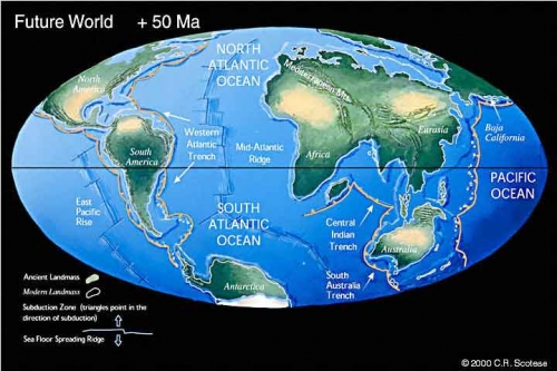
Image above copied from http://www.scotese.com/future.htm and shows the Earth as it might appear 50 million years in the future.
A great video clip of plate reconstruction as well as future plate positions can be viewed on the youtube video link below. I believe it uses Scotese plate reconstructions but please keep in mind the video clip lacks any bibliography or citations. While watching the video take note of the Indian plate moving across the ocean and then plowing into Asia (creating the Himalayan Mountains). I think Teddy would have really liked this video clip and would have looked forward to viewing the raw data used to determine the angles and speeds at which the plates are thought to have moved.
https://www.youtube.com/watch?v=NYbTNFN3NBo&feature=related
The second important research that Teddy Bullard conducted pointed to the mid-ocean ridge as a source of increased heat flow (Bullard 1954a). This was important in the field of plate tectonics because it provides evidence to support the process of plate tectonics. Matching the continental shelves of the plates is one thing, but providing a mechanism that explains why they are still not connected is very important. Proving that the mid-ocean ridge is an active (and literally hot) part of the crust is critical to plate tectonic theory.
As an established and respected scientist he was also able to influence the scientific community in favor of the theory of plate tectonics. For example in his concluding remarks at a symposium on continental drift (Bullard 1965b), he discusses how the paleontological and stratigraphic links across Pangaea need not be perfect. Erosion, changes in the position of the poles, and climate change all can alter or remove evidence of the bands of fossils or rock layers that give evidence that the continents were connected in the geologic past.
Other Important Scientific Contributions by Teddy Bullard
During World War II he worked for the British Navy in the field of submarine and sea mine warfare. His specialty was degaussing the hulls of ships, that is making them less vulnerable to floating German mines in the North Sea, Atlantic, and of course the British Channel. His research team used electrical currents that flowed through wires strung on and around the steel hulls of ships. These degaussed ships were far less likely to activate a magnetic mine.
He was leader on a science team that pioneered using potassium-argon system to date materials that fell into the middle category of materials that were too young to use the uranium technique yet too old for carbon-14 dating.
He is also known for making many contributions to Dynamo Theory, which helps explain the Earth's magnetic field (Bullard 1954b).
In the 1930's he conducted research using marine seismic reflection to describe the continental rise, which is the large pile of sediment that sits on the ocean floor and reaches up to the base of the continental slope. I believe this research sparked Teddy's interest in better understanding the differences between the geology of the land versus ocean plates as the relationship between the continental shelf, slope, rise, and abyssal plain leads itself to the plate tectonic theory.
Seismic marine reflection was most likely borne out of the need to locate underwater mines and submarines, but ended up allowing scientists to not only "see" the ocean floor, but also "see" how the layers of rock change below the ocean floor (without drilling any wells). Offshore oil exploration would be almost impossible without seismic marine reflection and a simple explanation of how it works is as follows:
Seismic marine reflection uses sound to map the ocean floor and show the depth that rock lithologies change. Quite literally a sound is generated in shallow water and the travel time of that sound wave is tracked as it "echos" back to the surface ship. Some of the energy of the sound wave penetrates the ground and bounces back to the surface ship as it interacts with changing rock density. The speed of sound varies in the ocean from about 1,480 m/s (in the SOFAR Channel which is about 750 meters deep) to about 1,550 m/s (in a trench over 5 km deep). Usually a value of 1,500 m/s is used to determine the depth of the water. As the sound energy enters the sediments and rock layers below the ocean floor the speed at which the sound moves again changes and bounces back information about the rock layers it is traveling through. A computer usually turns the series of numeric values into an image of what the ocean floor looks like as well as what the layers of sediments and rocks appear to be below the ocean floor. The image below is an example of a seismic marine reflection. Note the lines labeled "multiple", these are false boundaries created when the sound wave (after bouncing off the ocean floor) interacts with the ocean surface and in a sense starts over, thus creating a "false echo". Seismic reflection image interpretation is definitely an art as it is a challenge to figure out what is a real change in lithology versus the background "noise" and false returns.
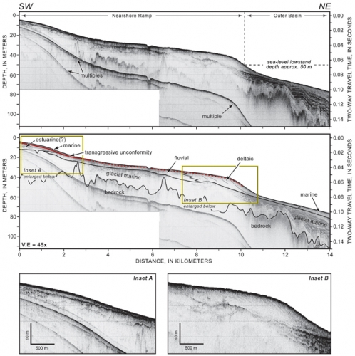
Above image copied from USGS Open File Report 2007-1373
Other Cool Stuff You Should Know About Teddy Bullard
During World War II he served on the stone frigate HMS Vernon. A stone frigate is the British Navy's way of identifying a naval establishment on land, so he never really served on a ship during the war.
He suffered from extreme seasickness, so his ocean geology studies were conducted on dry land (Sclater 2004).
He (like most geologists) had a great sense of humor and was well liked by the people he worked with.
Bibliography
Bullard E. 1954a. The Flow of Heat Through the Floor of the Atlantic Ocean, Proceedings of the Royal Society of London, Series A, mathematical and Physical Sciences, v. 222, n. 1150, A Discussion on the Floor of the Atlantic Ocean (Mar. 18th, 1954), p. 408-429.
Bullard E. and Gellman H., 1954b. Homogeneous Dynamos and Terrestrial Magnetism, Philosophical Transactions of the Royal Society of London, Series A, Mathematical and Physical Sciences, v. 247, n. 928 (Nov. 30th, 1954), p. 213-278.
Bullard E. 1962. The Deeper Structure of the Ocean Floor, Proceedings of the Royal Society of London, Series A, Mathematical and Physical Sciences, v. 265, n. 1322, A Discussion on Progress and Needs of Marine Science (Jan. 30th, 1962), p. 386-395.
Bullard E., Everett J.E., and Smith A.G., 1965a. The Fit of the Continents Around the Atlantic, Philosophical Transactions of the Royal Society of London, Series A, Mathematical and Physical Sciences, V. 258, n. 1088, A Symposium on Continental Drift (Oct. 28th, 1965), p. 41-51.
Bullard E. 1965b. Concluding remarks, Philosophical Transactions of the Royal Society of London, Series A, Mathematical and Physical Sciences, V. 258, n. 1088, A Symposium on Continental Drift (Oct. 28th, 1965), p. 322-323.
Bullard E. 1967. Reversals of the Earth's Magnetic Field, Philosophical Transactions of the Royal Society of London, Series A, mathematical and Physical Sciences, V. 263, n. 1143 (Dec. 12, 1968), p. 481-524.
Encyclopedia Britannica, On-line version: http://www.britannica.com/EBchecked/topic/84389/Sir-Edward-Bullard
NNDB, Edward Bullard, http://www.nndb.com/people/668/000168164/
Sclater J.G. 2004. Variability of heat flux through the seafloor: discovery of hydrothermal circulation in the oceanic crust, in Hydrogeology of the Oceanic Lithosphere, Davis E. E. and Elderfield H. eds, Cambridge University Press, p. 3-11.
Scotese website, http://www.scotese.com/future.htm
USGS Open-File Report 2007-1373. High-Resolution Geologic Mapping of the Inner Continental Shelf: Cape Ann to Salisbury Beach, Massachusetts, Section 4 - Geologic Interpretation, 15 pages, found at http://pubs.usgs.gov/of/2007/1373/html/interp.html
Wikipedia, Edward Bullard, http://en.wikipedia.org/wiki/Edward_Bullard