Biographic Information
Sir Edmond Halley was born in London, in 1656. A student at Oxford in the mid 1670's, he left school early to study the southern skies, near St. Helena. In months prior to this voyage, Halley corresponded with astronomer John Flamsteed, and published his first scientific work, in 1676. As an astronomer, Halley wanted to balance his love of the stars with his thoughts about Earth’s magnetism. Oxford and the Royal Society granted him a fellowship upon return from his southern voyage; the scientific revolution leading to breakthroughs in geomagnetism and astronomy in the 17th and 18th centuries was it's peak. Arguably, Isaac Newton and his revolutionary mathematics would have been hidden from the world without Halley's assistance. A worldly and charismatic traveler, Halley was very different from the more isolated Isaac Newton. Halley would gain from Newton’s insights, as a comet bearing Halley’s name was postulated to orbit around the sun. Sir Edmond may be best known for his prediction of his comet’s return, marking its periodicity of roughly 75 years. Halley pushed Newton to consolidate and share his brilliant insights that laid the foundation for planetary and stellar mechanics. Halley loved the stars as much as his passion grounded him to explore geomagnetism, a force from within the Earth.
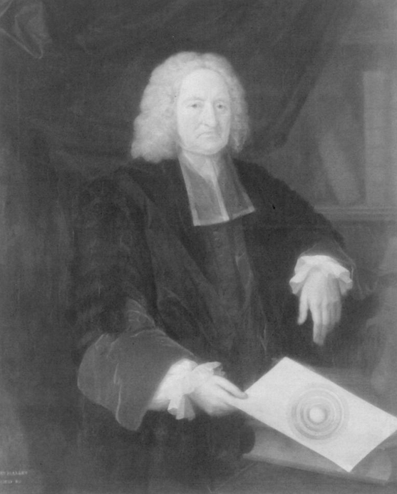
Halley at age 80, holding his sketch of the inner Earth (Geomagnetism), Cook 20011
Contributions to plate tectonic theory and/or geophysics
Newton’s mathematical explanations for planetary and stellar interactions complemented scientific work on geomagnetism. By 1635, the puzzle to understand magnetic forces on Earth had led to the realization that Earth’s magnetic field changed over time. For navigators, the ability to combine seaward positions from the stars with an understanding of compass reading could prove invaluable. Many viewed understanding magnetism on Earth as one of the most important problems to solve of the 18th century. Halley was at the center of this problem and provided insight that shaped the worlds view of Earth’s magnetic field into the 20th century.
Edmond Halley's greatest triumph came largely unrecognized. In 1699, Halley took part in three voyages of the Atlantic Ocean that would ultimately shape his legacy as a geophysicist. Remarkably, Halley was the first to do science a new way; his vessel would become his laboratory and his measurements would provide data for an unprecedented model of Earth’s magnetic field. Staying close to the shorelines of the Atlantic, Halley added 200 compass measurements to his 55 readings found in his 1683 paper. Using this data, Halley launched the modern art of cartography and created what became known as the Halley Lines, the first contour lines on a map (the original is lost).
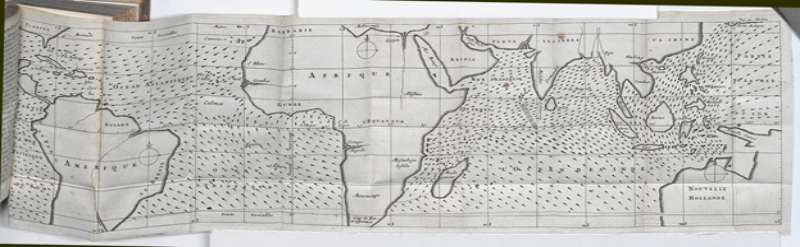
Edmond Halley relied on the stars; during eclipse events, such as those of Jupiter's moons, Halley could determine longitude data, utilizing historical logs that mapped eclipse events. His 1701 magnetic declination map combined compass readings with extrapolation, and more reliable celestial observations (though few and far between). How well did this map perform? The map on the left (below) is Halley's and the one on the right features an historic reconstruction of magnetic declination in 1700: 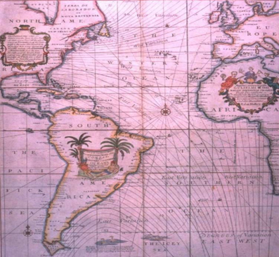
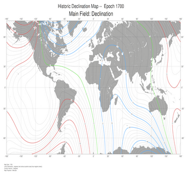
Figure 7. Halley’s (1701) original map of geomagnetic declination1 Historic declination map 1700 Epoch9
His chart based on declination readings, with extrapolations through the Atlantic, is still referred to in modern navigation. Further, Halley attempted to provide a mechanism for his Halley Lines based on a model of Earth’s core. The concept that the inner Earth is a source for magnetic fields was novel and part of Halley's legacy, but periodicity of the field and polarity may have been borrowed from other scientists. The Royal Society noted that Halley paid the widow of Peter Perkins for his papers, in 1680. Perkins was a friend of Flamsteed and a prominent mathematician (Cook, 2001). Although controversy surrounded the adoption of aspects of his model, the same spirit that drove him to assist Isaac Newton pushed science closer to a solution. Building on a concept of magnet field periodicity of 700 years and the western drift of the field, Halley created a model of earth’s magnetic field based on four distinct poles. The strange differences in declination throughout the world could be accounted for by two separate inner cores of the Earth. Although Halley was mistaken in his placement of the outer dipole in the earth’s mantle, the separation, between the core's surface and the mantle, with a “liquid” may be upheld; scientists have recently used advanced imagery that confirms the existence of liquid like surroundings on the core’s surface. Halley arguably pioneered the field of Geophysics and his basic construct for the generation of Earth’s magnetic field and a map of its contour have withstood the test of time. Would you agree? Use the Interactive Magnetic Declination map (see the link below) to view Earth's magnetic field change through time; how does a selection near 1700, compare to Halley's 1701 map, and to the reconstructed map, seen above?
Historic Magnetic Declination: 1590 to present
Sir Edmund Halley: Geophysics Publications
1) Halley, E., 1683, A Theory of the Variation of the Magnetic Compass, Phil. Trans. R. Soc, Lond., 13, 208-221.
2) Halley, E., 1692, An Account of the Cause in the Variation of the Magnetic Needle; with an Hypothesis of the Structure of the Earth, Phil.,Trans, R. Soc., Lond, 17,563-578.
3) Halley, 1701a, A New and Correct Chart Showing the Variations of the Compass in the Western and Southern Oceans, Phil., Trans., R. Soc., Lond., 21, 476-497.
Other cool stuff you should know
- As an astronomer, Halley's voyage to the Southern seas led to numerous publications in Astronomy. His 1679 paper has data on over 300 southern stars and Halley's insights into a transit of Mercury. The link below (Janus repository) lists Edmond Halley's contributions to Astronomy:
http://janus.lib.cam.ac.uk/db/node.xsp?id=EAD%2FGBR%2F0180%2FRGO%202
- Edmond Halley invented a diving Bell in 1691
- Halley produced a table to predict ocean tides
- The modern insurance agency is founded from Halley's actruary data
- Meteorogical maps and forecasting developed from Halley's isogonal investigations during his voyages:
Edmond Halley's map of the Trade Winds, 16757
- The Aurora event of the 1740's was witnessed in London; Halley correctly explains that "matter near the Poles" was interacting with Earth's stronger magnetic field to the North.
Bibliography
1) Cook, A., “Edmond Halley and the Magnetic Field of the Earth”, Notes Rec. R. Soc. Lond. 55 (3), 473-90 (2001) http://www.jstor.org/stable/53195 .
2) Edmond Halley, Father of Geomagnetism, http://geology.about.com/od/biographies_dh/a/halley.htm.
3) Evans, M.,” Edmond Halley, GeoPhysicist”, Physics Today 41(2), 41 (1988); doi: 10.1063/1.881144 http://dx.doi.org/10.1063/1.881144.
4) Courtillot, V., and Le Mouel, J., “THE STUDY OF EARTH’S MAGNETISM (1269–1950): A FOUNDATION BY PEREGRINUS AND SUBSEQUENT DEVELOPMENT OF GEOMAGNETISM AND PALEOMAGNETISM”, Rev. Geophys., 45, RG3008, doi:10.1029/2006RG000198
5) Geomagnetism and Edmond Halley, http://www.ieeeghn.org/wiki/index.ph/Geomagnetism_and_Edmond_Halley_%281656-1742%29.
6) Papers of Edmond Halley, http://janus.lib.cam.ac.uk/db/node.xsp?id=EAD%2FGBR%2F0180%2FRGO%202.
7) www.google.com/search?q=Halley+and+trade+wind+map&client=firefox-a&hs=Qv...
8) NOAA, WMM for 2010, http://ngdc.noaa.gov/geomag/WMM/image.shtml.
9) Historic Declination Map for Epoch 1700, ftp://ftp.ngdc.noaa.gov/geomag/Historic_UFM_maps/Historic_Mercator_Maps/...
10) Historic Magnetic Declination Interactive, http://maps.ngdc.noaa.gov/viewers/historical_declination/index.html