By LaRina Clark
Biographical information
July 30, 1920 - August 23, 2006
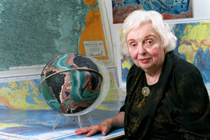
Tharp was born in Michigan to a mother who was a teacher and a father who was a soil classification map maker. Due to her fathers job taking her family all around the country, she learned to adapt to her surroundings. She was an American Geologist and Oceanographic cartographer who came about her career indirectly. Tharp graduated from Ohio University with Bachelor's degrees in English and music with several minors. Upon hearing that the University of Michigan was opening up their Geology program to women due to many men being needed for World War II she jumped at the chance to learn. She completed her Master's degee becoming a "Petroleum Geology Girl" in 1944 and went to work for Standard Oil and Gas company in Tulsa, Oklahoma. When she arrived she learned that women were not permitted to do field work. As a woman in a male dominated field, she was placed in an office that coordinated maps and data for her male colleagues.
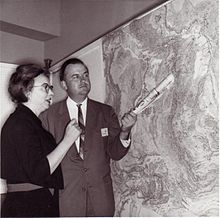
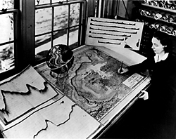
Quickly tiring of the job, she earned a second degree in mathematics from the University of Tulsa and moved north to Columbia University. It was there Tharp was to work under eminent geophysicist W. Murice Ewing. She became the research assistant to Bruce Heezen and the two worked together as a creative couple. He out in the field on the ships and she, back at the university creating her maps. Long before comptuers, Tharp created latitude degree by longitudinal degree maps that made sense of the sonar readings sent back by Heezen. Her drawings were the backbone of her contribution to Plate Tectonics. She and Heezen worked together for almost thirty years until Heezens death in 1977.
In the thirty years, Tharp and Heezen created the first scientific map of the entire ocean floor. It started with the North Atlantic and discovering a Mid-Atlantic ridge with a rift in the middle similar to the one found in the rift Valley in East Africa. Tharps contributions to Plate Tectonics are supported by her achievements and the importance of her maps. "She was a pioneer in her porfession,succeeding as a woman in a field dominated for decades by men. But most of all she was a wonderful person, a great colleague and a happy friend to so many of us." said Mike Purdy, director of Lamont-Doherty.
Contributions to Plate Tectonics / Our current view of the solid Earth
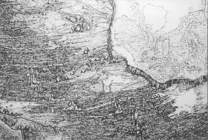
Tharp took raw data and did what comptuers do in todays world. She intrepeted it and made it understandable by man. Once plotted, her drawings showed everyone who looked at them the key to Plate Tectonics. Initially Heezen refudsed to accept this find, preferring Expanding Earth hypotheses that was a favorite of Ewing. After Tharp pointing out the correlation between the seismological records and undersea earthquake epicenter, Heezen was on board with the evidence. In 1957 Tharp and Heezen published their first phisiographic map of the North Atlantic. 20 years later they collaborated with Heinrich Berann (a landscape painter) to pubilsh their map of the entire ocean floor. PUT PHOTO OF PHYSIOGRAPHIC MAP HEE
Her connection between the deep valley centered along the axis of the Mid-Atlantic Ridge, along with the linkage of the major crustal plates for over 64,000 km around the Earth, not only showed, but confirmed the concept of Plate Tectonics and Crustal Movement.
Other Scientific Contributions
Tharp started mapping the ocean in an effort to locate downed aircraft from World War II using photographic data in 1948.
Gender restricted from shipboard research, Tharp pieced together what Heezen gathered and foraged a path in a male dominated career.
Other cool stuff you should know
Tharp and Heezen circumvented navy classification policies and created a physiographic map as opposed to a contour map of the ocean floor.
Upon her retirement in 1983 operated a map-distribution business.
Jacques Cousteau was originally a doubter, but when his film of the ocean floor came back supporting Tharp's maps, he went on to show his video at the International Oceanographic Congrss in 1959 and officially supported her work.
Tharp was barred from working at Lamont while Heezen was permitted to stay due to tensions between Heezen and Ewing over publication credit and priority in late 1960.
Tharp was finally given the opportunity to go to sea in 1965 on a reserach cruize organized on Duke University's sea vessel.
Tharp received the following awards:
- 1978 received the Noational Geographic Society's Hubbard Medal
- 1996 received the Society of Women Geographers outstanding Achievement Award
- 1997 received the Phillips Society fo the library of Congress as one of the 20th Century's Outstanding Cartographers
- 1999 received the Woods Hole Oceanographic Institution's Pioneers in Oceanography award
- 2001 First Annual Lamont-Doherty Earth Observatory Heritage Award
- 2001 Geography and Map Division of the Library of Congress and Woods Hole Oceanographic Institution
Bibliography
http://www.columbia.edu/cu/news/o6/08/tharp.html
http://www.encyclopedia/com/topic/marie_Tharp.aspx
http://c250.columbia.edu/c250_celebrates/remarkable_comumbians/marie_tharp.html
http://www.nea.org/tools/lessons/67383.htm
http://www.sciencedirect.com/science/article/pii/S1474706510001026
http://mentalfloss.com/article/60481/how-one-womans-discovery-shook-foun...
Wayne, Tiffany. American Women of Science since 1900. Santa Barbara, US:ABC-CLIO, 2010. ProQuest ebrary. Web.11 September 2016.
"Marie Tharp." Encyclopedia of World Biography. 2nd ed. Vol. 15.Detroit: Gale, 2004. 162-164. Gale Virtual Reference Library. Web. 11 Sept. 2016.