Unit 5, Lesson 8: Landforms (1)
Lesson 8 Introduction
Thus far through the course, we have focused on one of the state factors of soil formation: climate. (We have also studied how water specifically contributes to this process.) Now we turn our attention to the other state factors. In this unit on geology and landforms, we will consider and discuss three of the remaining four natural state factors of soil formation: parent material, topography, and time.
Parent material is obviously a critical component of the pedogenic system and the Critical Zone—all the other state factors of soil formation act upon the parent material to create soil, and thus the original, unweathered composition of the parent material plays a unique role in the weathered product. In Lesson 8, you will learn (review) basic concepts of geology to remind you that rocks and sediments have widely ranging textures and compositions formed in a wide range of environments. These variations, in turn, can affect soil formation and Critical Zone processes.
The landforms and topography of a region control a variety of Critical Zone processes. You will learn in Lesson 8 that the plate tectonic setting plays a first-order role in determining the topography of a site and thus in determining whether soils develop and accumulate or are subject to erosion. In addition, the geologic setting determines other aspects of environmental control on the Zone. As you study Lesson 8, consider the following questions: Can unique depositional environments consist of characteristic landforms? If so, what can those landforms show us about Critical Zone processes? Do soils developed on unique landforms have unique characteristics? What is the slope and aspect of a site and how do these relate to solar heat budgets and vegetation?
Lesson Overview
The geology of a region controls the parent material available for pedogenesis. Parent material can be represented by a wide range of rock types of varying geochemical compositions, it can be lithified (hardened) or unconsolidated, and it can be relatively recent in age or billions of years old. The geologic setting of a region, past and present, also determines whether or not mountains or valleys exist, thereby exerting a first-order influence on the topographic setting in which Critical Zone processes function and soils form. Furthermore, the geologic setting will determine whether parent material lies within an active setting, perhaps only recently exposed to pedogenic processes; or within a more stable setting in which soil formation may continue unabated, subject only to the vagaries of climatic and biotic change.
What will we learn about in Lesson 8?
- Basic geologic concepts
- Rock types and the rock cycle
- Plate tectonics
- Geologic time
- Weathering, erosion, and deposition
- Geologic maps
Learning Objectives
By the end of this lesson you should be able to:
- Describe three rock types and the processes by which they form
- Discuss the rock cycle and plate tectonics
- Differentiate between relative and absolute age dating
- Describe the difference between weathering and erosion and their relationship to soils
- Differentiate between bedrock and surficial geologic maps and apply them to understanding the Critical Zone at your study site
What is due for Lesson 8?
Lesson 8 will take us one week to complete. As you work your way through these online materials for Lesson 8, you will encounter additional reading assignments and hands-on exercises and activities. The chart below provides an overview of the requirements for Lesson 8. For assignment details, refer to the lesson page noted.
Please refer to the Calendar in Canvas for specific time frames and due dates.
| ACTIVITY | LOCATION | SUBMISSION INFORMATION |
|---|---|---|
| Report (2 pages) on parent material questions | pages 4, 7 | Post to the Lesson 8 - Geology dropbox in Canvas |
| Report (2 pages) with relevant maps | page 8 | Post to the Lesson 8 - Geologic Map dropbox in Canvas |
Questions?
If you have any questions, please post them to our Questions? discussion forum (not e-mail), located under the Discussions tab in Canvas. I will check that discussion forum daily to respond. While you are there, feel free to post your own responses if you, too, are able to help out a classmate.
What is Geology?
Geology is near and dear to my life since I am a geologist. I cannot count the number of times I have been asked whether or not I have been out on a "dig" recently or whether I dug up any arrowheads or pottery during my recent field excursions. Geology is not archaeology! For this reason, I want to be sure that you are exposed to some basic information about geology, including a definition. Be aware that geology is a science subdivided into numerous sub-disciplines and that numerous university geoscience departments around the world offer degrees ranging from two-year associate's degrees to the Ph.D. This lesson should be viewed as an introduction to only the very basics of geology!
Check this out . . .
A set of talks covering various topics within the Geosciences is available for free use in schools at Your Planet Earth [1].
The Pennsylvania Topographic and Geologic Survey provides online resources for teachers [2], including lesson plans, relating to the geology of Pennsylvania. Visit the site and follow the hyperlink "For Teachers" to "Lesson Plans." Other states may offer similar resources.
Reading assignment
Please visit and read the following sites to be certain that you understand the basics of the field of geology.
Once you have completed that reading, you should understand that geology is the study of Earth: the materials of which it is composed, the processes that created those materials, and the history of the planet.
Much of what geologists work on focuses on rocks, classified into three basic types: igneous, sedimentary, and metamorphic.
Please visit the "Geology" section of About.com [5] to learn more about rocks.
- Follow the link to "Identify rocks"
- Continue on to "About igneous rocks"
- Follow the links through the descriptions of sedimentary and metamorphic rocks
You will be asked some questions related to these readings in the following activity.
Geology Activity
Activity
For this activity, I want you to begin writing a two-page report that you will continue working on in another activity in this lesson.
NOTE:
For this assignment, you will need to record your work on a word processing document. Your work must be submitted in Word (.doc) or PDF (.pdf) format so I can open it. In addition, documents must be double-spaced and typed in 12 point Times Roman font.
Directions
- Having read the materials listed on the previous page, think about their relevance to the Critical Zone and pedogenesis.
- If all state factors of soil formation except a parent material (in this case, rock type) were held constant in a select locale, do you think similar or different soils would be developed on the different rock types?
- Why?
- Save your document as either a Microsoft Word or PDF file in the following format:
L8_geologydocument_AccessAccountID_LastName.doc (or .pdf).
For example, student Elvis Aaron Presley's file would be named "L8_geologydocument_eap1_presley.doc"—this naming convention is important, as it will help me make sure I match each submission up with the right student!
- Continue with this lesson. You will continue this report in the activity on page 7 of this lesson.
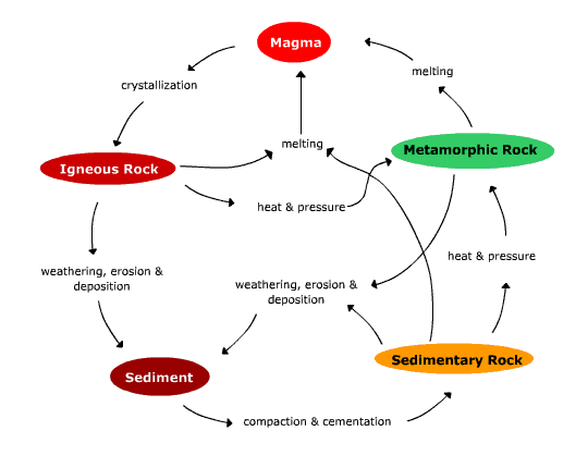
The Rock Cycle and Plate Tectonics
Geologists use the term rock cycle to describe and simplify the complex interactions through which the three rock types can be linked to the processes that created them. One version of the rock cycle is illustrated below.
A simple animation of the rock cycle can be viewed at Exploring Earth [7]. Follow the links through steps 2 and 3, ignoring the assignment in step 3.
Reading assignment
The rock cycle is driven by plate tectonics and the presence of water. To review some basic information about plate tectonics, visit and read:
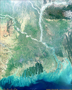
Notice that oceanic crust is denser than continental crust, hence continents exist above sea level and they are a net source of sediment to the ocean basins. Also note that each plate boundary type is described by characteristic processes, some of which lead to the development of uplifted regions, while others lead to downwarped or subsided portions of crust. Subsided areas often contain thick sediment piles full of relatively fresh bedrock and mineral nutrients derived from the nearest uplifted zones. For example, where the Indian sub-continent has collided with Eurasia, a large mountain belt has risen, the Himalayas, from which enormous quantities of sediment are shed into the Bay of Bengal.
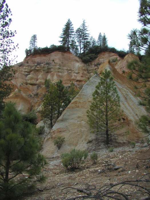
Tectonically active regions of Earth typically display characteristics and landscapes that are different from less active, more stable regions of the planet. In the next lesson, you will learn about the unique features of five geomorphic environments and settings. But now, while you've been thinking about plate tectonics, I want you to view images of landforms from tectonically active regions [10]; remember these when you study the five geomorphic environments later.
Obviously, much of the rock cycle includes processes which operate deep within Earth's interior, the details of which fall well beyond the purview of this course. While it is important to understand that these processes occur, in this lesson we will focus on those portions of the rock cycle that are immediately relevant to and operate within the Critical Zone: weathering, erosion, and deposition. To fully understand these processes, it is as important to know the rates at which they are active, which often requires the perspective of geologic time.
Geologic Time
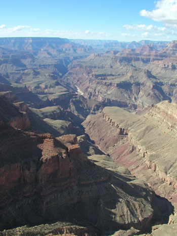
Geologists have a much different sense of time than most of our fellow citizens of Earth. It is not unusual for me to tell friends and family about my studies of the most recent episode of past greenhouse warmth, ~50,000,000 years ago, as an analog to Earth's not-too-distant globally warmed future, and in return be subject to gaping jaws or glazed eyes. Geologists' perception of time derives from our study and understanding of the history of Earth and the vastness of geologic time. Often these concepts conflict with Biblical interpretations of geologic time; nevertheless, the majority of geologists know and accept that features like the Grand Canyon did not form in 6,000 years. Personally, I find the vastness of geologic time to be much more inspiring! But like the rest of you, I still wish my weekends and vacations were longer.
Recall from the lesson on soils that time is one of the five natural state factors of soil formation. A parent material long subjected to the forces of climate, topography, and biota is more likely to develop into soil than one subjected to only brief exposure to those factors. Following from that, the structure, texture, and horizonation of a soil can and often will become more developed and mature with time. Also, remember from the paleoclimatology lesson that paleosols exist and provide a record of the history of the Critical Zone through time. Billions-of-years-old paleosols are known to exist, providing witness to the evolution of the Critical Zone.
To learn about various aspects of geologic time, including the methods that allow us to measure geologic time and their development, visit and read:
- Geologic Time [11]
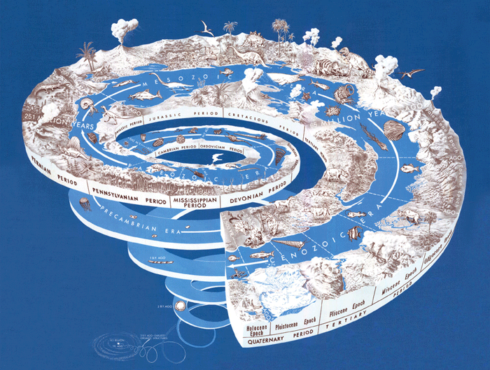
View the figure below, being sure to note the human figure in the Pleistocene Epoch—human history represents only a small fraction of all of Earth history, yet as we will learn in future lessons, we have quickly become the dominant force in shaping Earth's surface.
Reading assignment
As important to understanding the vastness of geologic time is the perspective it brings to understanding the rates of surface processes in the Critical Zone. Visit "Chapter 6: Geologic Time, Geologic Processes Past and Present - Uniformitarianism [13]" and focus on the description of uniformitarianism versus catastrophism.
Also, see "Geological Time [14]" for issues relating to teaching about geologic time and the notion that it requires innovation in our sense of reality.
Weathering, Erosion, and Deposition
Weathering describes the chemical and physical decomposition of rocks and minerals through contact with our atmosphere. Rocks and minerals subject to weathering are not moved during decomposition. In contrast, erosion involves the entrainment and transport of rock and mineral particles by wind, water, ice, and gravity; a reduction in velocity of the transport medium or increase in resistance of the transported particles results in deposition or the addition of material to the landscape. Note that biota (i.e., biogeomorphology [15]) can play an important role in both weathering and erosion.
Reading assignment
To learn more about the processes of weathering, erosion, and deposition, please visit and read the following:
- Erosion and Weathering [16]
- "Weathering" at Wikipedia [17]
- "Erosion" at Wikipedia [18]
- "Deposition" at Wikipedia [19]
In addition, read:
- "Physical and chemical controls on the critical zone" by Anderson et al. (2007)
which is located in Library Reserves, so that you can develop a more evolved view of the relationship between these processes and the concept of the Critical Zone as a "feed-through reactor."
You will be asked some questions related to these readings in the following activity.
Activity
For this activity, I want you to complete the two-page report you began on page 4 of this lesson.
Directions
- Open the document you began on page 4.
- As you read through the materials listed above, recall our lesson on soils and consider the role these processes have in shaping the Critical Zone. Soils consist of unconsolidated material subjected to physical and chemical weathering.
- Do you think all soil parent materials were subject to erosion and deposition?
- Are some soils the result of weathering of bedrock in place, that is not subjected to erosion and deposition?
- If so, how do soils developed directly from bedrock differ from soils developed on unconsolidated material, if at all?
- Re-save your document.
Submitting your work
Upload your report to the "Lesson 8 - Geology" dropbox in Canvas (see the Modules tab) by the due date indicated on our Canvas calendar.
Grading Criteria
You will be graded on the quality of your writing. You should not simply write responses to the questions and submit them to me. Instead plan on writing a short stand-alone paragraph (or page or whatever you decide is necessary considering any constraints I might have placed on you) so that anyone can read what you've written and understood it. You should strive to be specific and complete in responding to the questions. Your answers should be analytic, thoughtful and insightful, and should provide an insightful connection between ideas. The writing should be tight and crisp with varied sentence structure and a serious, professional tone.
Exploring Geologic Maps
Geologists use and create a variety of maps to display the results of our work. Among the simplest of these are maps of bedrock and surficial geology. Bedrock maps display the various rock types in a region. They are best understood if you can imagine stripping away all of the unconsolidated sediment, soil, and vegetation from the land surface down to solid rock. Bedrock maps do not indicate that XYZ rock type can be found at ABC locale; instead, they show what exists in the subsurface beneath the soil and sediment and vegetation. In some places, particularly out west, rocks do exist at the surface! In that case, the bedrock map shows the rock type at the surface.
Surficial geologic maps differ from bedrock maps in that they display the sediments mantling bedrock. In some places, no sediment exists and, therefore, the surficial map may show bedrock. But in others, for example in northeastern and northwestern Pennsylvania (where multiple glaciers dumped their sediment load over the past several hundred thousand years), surficial geologic maps differentiate between the various materials moved into the region by glaciation and may even differentiate between deposits of different ice ages.
Now let's take a look at the geologic maps available for your study site.
Activity
Directions
- Go to USGS AASG [20].
- Choose Map Catalog.
- Use the Google Maps/Location interface to find information for your study site. Use a similar approach as in the Groundwater study - bounding coordinates that are small, to begin with, but reach out further to find more information.
- From the check-box options provided, select bedrock and surficial under Geology heading, then click Search.
- Assess the available resources for your study site.
- Describe the results of your search and include bedrock and surficial geologic maps in a report no longer than two pages.
- Choose Resources and Hazards too—include a resource and hazard assessment of your site in the same report with all relevant maps.
- Save your document as either a Microsoft Word or PDF file in the following format:
L8_geologicalmaps_AccessAccountID_LastName.doc (or .pdf).
For example, student Elvis Aaron Presley's file would be named "L8_geologicalmaps_eap1_presley.doc"—this naming convention is important, as it will help me make sure I match each submission up with the right student!
Submitting your work
Upload your report to the "Lesson 8 - Geologic Maps" dropbox in Canvas (in the lesson under the Modules tab) by the due date indicated on our Canvas calendar.
Grading Criteria
You will be graded on the quality of your writing. You should not simply write responses to the questions and submit them to me. Instead plan on writing a short stand-alone paragraph (or page or whatever you decide is necessary considering any constraints I might have placed on you) so that anyone can read what you've written and understood it. You should strive to be specific and complete in responding to the questions. Your answers should be analytic, thoughtful and insightful, and should provide an insightful connection between ideas. The writing should be tight and crisp with varied sentence structure and a serious, professional tone.
Summary and Final Tasks
Geology, the study of Earth, is a broad and complex discipline. In this lesson, you reviewed some geologic concepts, including the difference between the three basic rock types. You read briefly on plate tectonics, geologic time, the rock cycle, and various related processes focusing on weathering, erosion, and deposition. I asked you to consider several questions regarding the role of parent material, erosion, and deposition on soil formation. Finally, various types of geologic maps were explored—the accessibility and usefulness of these resources are the most important lesson for you to draw here.
Reminder—Complete all of the lesson tasks!
You have finished Lesson 8. Double-check the list of requirements on the Lesson 8 Overview page to make sure you have completed all of the activities listed there before beginning the next lesson.
Tell us about it!
If you have anything you'd like to comment on or add to, the lesson materials, feel free to share your thoughts with Tim. For example, what did you have the most trouble with in this lesson? Was there anything useful here that you'd like to try in your own classroom?