Lesson 1: Geopolitics - An Introduction to Historical Roots and Theories
Overview
Two important overarching ideas will be conveyed in this lesson:
- Contestation: places, regions, and territories are always contested. The very nature of their socially constructed existence is based upon political frameworks that determine who belongs (or is included) and who does not belong (or is excluded) from a particular place.
- Context: simply put, context matters. Political events occur in a particular location with specific socio-cultural, economic, linguistic, ecological, physical, geographic, and historical settings. These factors at least partially define what happens and what possibilities for peace and resolution are available within a geopolitical context.
Lesson Objectives
By the end of this lesson, you should be able to:
- describe the concepts of place and scale;
- explain the concepts of structure and agency;
- describe places in the world as being unique and interconnected;
- contextualize current events as occurring within a set of interconnected scales, and as being performed by geopolitical agents;
- consider how the actions of geopolitical agents happen within structures; and
- consider the multiple forms of power that underlie geopolitics.
Required Readings and Assignments
Please see your Canvas course space for a complete listing of this lesson's required readings, assignments, and due dates.
Questions?
If you have any general course questions, please post them to our Course Questions Discussion located in the General Information Module in Canvas. I will check that discussion forum regularly to respond as appropriate. While you are there, feel free to post your own responses and comments if you are able to help out a classmate.
Geography & Politics
Required Reading Reminder
Please begin by reading the Prologue and Chapter 1 of Flint, C. (2016). Introduction to Geopolitics (3rd ed.). London: Routledge.
Whether you are new to the discipline of geography or not, most people were introduced to the field through looking at maps or elementary school exercises where you were made to memorize capital cities. While these activities are indeed fundamental to geography, the discipline expands well beyond the confines of maps and capital cities. In this course, you will be introduced to a subset of Human Geography, called Political Geography, or Geopolitics.
Our study of Geopolitics will guide us through the process of situating events within a particular context. That is, through our work in this lesson, and throughout the semester, we will try to better understand how and why things unfold in certain ways in specific places. And, while we may still be quite perplexed at the various impasses we see on the global geopolitical stage, we will, at the very least, better understand the complexity involved in some of these seemingly intractable situations.
In this first lesson, all of our activities ask you to think about your hometown and the various characteristics that make it a place you are intimately connected to - indeed, for many of us, it shapes various aspects of our identity and perspective on the world around us. So, we will begin the discussion of geography and politics by utilizing the example of State College, home of Penn State University!
Until I was in the 4th grade, my family moved around quite a bit. My father was in the US Army, so I was born in Germany, then we moved to North Carolina, then back to Germany, then to Texas, all before I started the 4th grade and he retired and we finally moved to State College, PA. So, while I can identify with being an "Army brat", I also consider State College, PA my hometown. Thus, I will use State College, PA (including University Park) as my hometown example.
Below is a screenshot of State College, PA taken from Google maps.
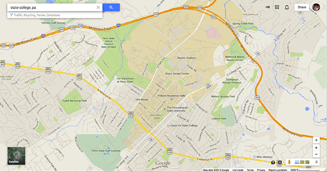
University Park, or Penn State, is located centrally and is the tannish-brown portion of the map. The grey portions of the map constitute the town of State College and its surrounding villages. The map below zooms in to better view downtown State College, PA and the central part of the University Park campus.
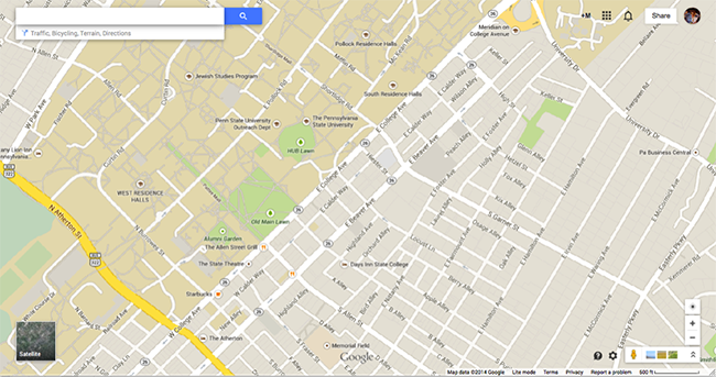
Both the size and close spatial relationship of the University are certainly of note when we think about the relationship between the University community and State College residents. Looking at the two maps above, we could gather some information about the “spatial organization of human activity” (Flint, 2016, p. 22) in State College. But, as Flint noted, “the term space is more abstract than place...(and) gives greater weight to functional issues such as the control of territory, an inventory of objects... within particular areas, or hierarchies and distances between objects” (Flint, 2016, p. 22).
But, if we are to understand State College, PA to a greater degree - if we want to understand how and why State College, PA is a unique, historied, and dynamic place - we must investigate the situated characteristics embedded within the town's social and physical geography.
Flint explains, “(t)he economic, political, and social relationships that we enjoy and suffer are mediated by different roles for different spaces” (2016, p. 22). The spaces of the University and the town, and their corresponding roles are apparent in the maps above. However, the people who occupy the spaces - as students, residents, University employees - flow through and occupy these spaces in various roles throughout the day. As such, University life (i.e., academics, sports, social events, etc.) flow into (State College) residential spaces; and local residents, in turn, go on to campus to listen to an evening community lecture, watch a sporting event, or get an ice cream cone at the PSU Berkey Creamery.
One of the reasons that State College is an interesting place to begin thinking about Geopolitics is because of the ways in which not only place and identity but also the politics of inclusion and exclusion (and the regulation of these categories) are enforced and/or contested by individuals or groups occupying “different roles” with regards to “different spaces”.
Listen to This
To give you an “embodied perspective” (Flint, 2016, p. 6) into one of the points of contention between University and local residential life, listen to the Prologue in this episode (396) of This American Life: #1 Party School [1].
As you listen to the episode, think about:
- the various spaces people occupy and are invested in (keeping, maintaining, controlling, or traversing);
- the perspective from which they occupy or utilize the various spaces;
- how the various people (stakeholders) engage with each other to moderate use of the spaces; and
- how place and identity are wrapped up in a politics of inclusion/exclusion and the regulation of space as a result of power politics.
The Magnificent African Cake
Likewise, to give you greater insight into the history behind the maps (Figure 1.1) featured in Flint (2016), p. 23, watch Africa: A Voyage of Discovery, Part 6 (of 8) "The Magnificent African Cake".
In order to better understand decolonization and contemporary geopolitics on the African continent, a history of colonization is critical. Thus, as you watch the sixth installment of Africa (hosted by Basil Davidson), I want you to again consider the politics of place and identity.
As you watch "The Magnificent African Cake", think about
- how the colonizers viewed Africa as a space to be carved out, conquered, occupied and exploited for its rich resources and cheap (enslaved) labor;
- how the native African population lived in a grounded place that served as the backdrop for social organization, environmental sustenance, and regional territorial cooperation or conflict; and
- how the carving up of “the magnificent African cake” by colonial powers has impacted the continent’s modern history.
BASIL DAVIDSON: The West Coast of Africa-- looking today much as it did 100 years ago. At that time, the old evils of the slave trade had become a distant, though disgraceful, memory. But they've now opened a new chapter of confrontation along these tropical shores. In past years, Europeans had come here for profitable business. Now they wanted more, much more.
Old trading posts, like this one, had long been the scene of a partnership between traders from Europe and local Africans. By the 1880s, that old partnership was being swept away in a dramatic change-- the outcome of a new European drive for overseas empire. Industrialized countries led by France and Britain had begun to invade the black continent each hoping for new sources of raw materials for its factories, new markets for its manufacturers, and new positions of advantage against its rivals.
This was called the scramble for Africa. By 1914, only two countries remained outside European possession-- Liberia in the west and Ethiopia in the east. Britain had seized the lion share of control-- Egypt and Sudan in the north, the immense wealth of South Africa, valuable colonies like Rhodesia and Kenya, and richly populated territories such as Nigeria and the Gold Coast.
France had invaded Algeria in the 1830s. Now after new wars of conquest, she added more colonies to her empire south of the Sahara including the island of Madagascar. Little Portugal carved out two vast colonies, Angola and Mozambique, while imperial Germany took the Cameroons and southwest Africa and, on the east coast, Tanganyika. The vast Congo Basin fell to King Leopold of the Belgians. Italy and Spain completed the enclosure. The fate of the continent was utterly changed.
Between the colonizing powers themselves, the carve-up was peaceful but their rivalry was intense. In 1884, a congress of the competing governments met in Berlin to settle their disputes. Germany's Iron Chancellor Bismarck was there. And active behind the scenes was the ambitious Belgian king. He spoke for them all when he said, "I am determined to get my share of this magnificent African cake." Any power that could occupy African soil could effectively claim it.
[MUSIC PLAYING]
Now the task was to stake out frontiers in utterly uncharted land. Said the French prime minister, "we have embarked on a gigantic steeplechase into the unknown." The British prime minister, Lord Salisbury, was to say of this period, "we've been engaged in drawing lines on maps where no man's foot has ever trod. We've been giving away mountains, and rivers and lakes to each other only hindered by the small impediment that we never knew exactly where we were."
[MUSIC PLAYING]
The great game was to get hold of places and positions of advantage over rivals no matter what irrational frontiers might result. One of the most absurd cases was the magnificent Gambia river. Britain had long held Bathurst, Banjul today, and was determined to keep this river route to the interior. But France, invading from the West Coast, enclosed all the territory surrounding the Gambia river in her new colony of Senegal.
So the French were naturally eager to obtain the Gambia river. They offered Britain, in exchange, the much larger and richer Ivory Coast. But the British parliament insisted on keeping the Gambia thus dividing the peoples of the region. And the result was and is a country that is 300 miles long but never more than 30 miles wide.
[SHOUTING]
What the African inhabitants might think of this colonial carve-up was never asked. The European idea, in the words of one British governor, was to seize African territory and then, as much as possible, rule the country as if there were no inhabitants.
In fact, European contempt for Africans now reached new depths and no wonder. For how otherwise and by asserting that Africans were helpless children, lazy savages, could Christian Europe justify taking their countries away from them?
The helpless children, meanwhile, sang their own version of a famous hymn, "Onward Christian soldiers into heathen lands, prayer books in your pockets, rifles in your hands. Take the happy tidings where trade can be done. Spread the peaceful gospel with the Gatling gun."
The European invasions were widely resisted. Conquest was never easy. And sometimes, as these old drawings and photographs testify, conquest led to a ruthless killing that later generations would prefer to forget.
[MUSIC PLAYING]
[CALL TO PRAYER]
Resistance took many shapes. In French West Africa, a focal point was found in Muslim loyalties. Many heroes, still unforgotten, came on that scene. Some, like the Senegalese religious leader Amadou Bamba, offered the way of peace but was still sent into exile.
Others, like the fierce warrior leader Samori, fought off French attack after attack and was crushed and exiled only after years of war. Death took many-- strong or weak. With the skulls of earlier wars displayed in their capital Kumasi, the powerful Ashanti nation ruled over most of modern Ghana. Led by their kings, who had the title of Asantehene-- they'd long defended their country against Britain but now they desperately wanted a peaceful settlement.
In 1895, fearing a disastrous war with Britain, King Prempeh made a strong bid for peace from his palace here at Kumasi. He offered the British the right to establish in Ashanti a chartered company with all the concessions-- the privilege that such a company could possibly desire. But it wasn't enough for the British now wanted territorial possession as well as a privilege.
[GUNFIRE]
The Ashanti nation had already fought long hard battles against the British. But this time, in 1896, they decided to surrender.
[GUNFIRE]
In a ceremony of deliberate humiliation, the King was made to kiss the British commander's boot and then sent into exile. But it wasn't the end of the story. The British now blundered. A new British governor, Sir Frederick Hodgson, decided that he had to get possession of the sacred Golden Stool-- symbol of the Ashanti nation's soul. Arriving at the British fort here in Kumasi, he ordered the assembled chiefs to hand the stool over. Worst still, he demanded the right to sit on it-- something that no person had ever been allowed to do, not even the King himself.
[GUNFIRE]
To Hodgson's final insult, the Ashanti replied with war. This little fort at Kumasi is what the British had built, just in case, and now they sorely needed it. The few dozen British inmates of the fort were besieged for months and had to eat rats to stay alive.
Hodgson's act of folly had exacted a bitter price. Efforts to send in relief from the coast were repeatedly frustrated by Ashanti resistance until finally, the governor and his wife got away to the coast and the absurd but tragic affair could be closed. This ended the war between Britain and Ashanti and a year later, in 1901, the British quietly annexed the country which became part of the colony of the Gold Coast.
All over Africa, the new military technology of automatic guns gave easy victories to the invaders.
[AFRICAN SINGING]
Countless resistors died-- many thousands at the single Battle of Omdurman in Britain's conquest of Sudan. Meanwhile, in another part of Sudan, the French were also scoring victories. For the most part, public opinion rejoiced. For were these not a victories over an inferior species-- a kind of joke humanity?
[AFRICAN SINGING]
There were some critics but not many and their voice was ignored or silenced. What really mattered was to do down one's European rivals. If you were British-- to get the better of the French in West Africa or of the Germans in East Africa. While orphans, like little Uganda, were left on the protective doorstep of Father John Bull.
Even before 1900 there came a new source of conflict-- settlers from Europe-- French in the far north, Dutch and the British in the far south, and some Germans. Other settlers were attracted to the good farming land of the east, Tanganyika, northern and southern Rhodesia, and the British territories of Uganda and Kenya. Once again, nobody asked permission. An early French governor had laid down the golden rule. Wherever good water and fertile land are found, he said, settlers must be installed without questioning whose land it may be. The settlers, not surprisingly, agreed.
The next step in East Africa was to build a railway from the coast to the interior. The line was completed in 1901 and millions of acres of good farming land in Kenya were opened to white ownership and settlement for the buying price of next to nothing. These white strangers, oddly enough, were at first welcomed by the African inhabitants.
But the welcome didn't last for long. For they soon discovered that colonial government wanted them to give things-- above all their land and their labor. These colonial demands provoked a repeated resistance. And against that resistance, the colonial government with white settlers arriving in ever larger numbers from Britain waged a war with little mercy. And, of course, with rifles and machine guns against spears and arrows.
[NON-ENGLISH SPEECH: It was all so cruel and we had never done them any harm. But the noise of guns scared people into hiding and their houses were burnt down.]
[DRUMS BEATING]
BASIL DAVIDSON: This beating down of a sometimes violent and desperate African protest was called pacification, or less politely, hammering. A British officer then fighting in Kenya, kept a sadly, instructive diary.
BRITISH OFFICER: "Marched into Fort Hall and the expedition comes to an end. To my mind, the people of the Embu have not been sufficiently hammered, and I should like to go back at once and have another go at them. During the first phase of our expedition against the Irani, we killed 797 niggers and during the second phase against the Embu, we killed about 250."
BASIL DAVIDSON: There was, in fact, much more of the same thing in the sixth campaign against the Kenya Nandi, for example. British troops reported killing 1,117 people besides seizing all their livestock. In 1906, a junior British minister in London cabled this protest, "Surely it cannot be necessary to go on killing these defenseless people on such an enormous scale." The minister's name was Winston Churchill but on that occasion, his intervention had no effect.
[NON-ENGLISH SPEECH: Life changed tremendously when our land was taken away. People would take refugee with the missionaries. The white men came and built right in front of our homes. We were driven away, into refuge.]
[MUSIC PLAYING]
[ON SCREEN TEXT: At last, the Settler reaches the site of his future home, and natives begin to dig foundations and gather materials.] [ON SCREEN TEXT: The natives are excellent workers and soon the house is finished. The natives, their long day over, go to their huts and the Settlers return to their home.] [NON-ENGLISH SPEECH: When they took the land the people were chased off and barbed wire was put up all around.]
[DRUMS BEATING]
BASIL DAVIDSON: By 1915, about four million acres of African farming land in Central Kenya had been given to about 1,000 British settlers. By the 1920s, about half of the able-bodied men of Kenya's two largest farming peoples, the Kikuyu and the Luo, were working as laborers for British newcomers. How was that done? The answer, once again, was something new in Kenya-- taxation. To cultivate these splendid acres, it was necessary to make Africans pay taxes in cash. Having no money economy of their own, Africans could pay tax in cash only if they went to work for a European wage. An old Masai recalls those early days.
[NON-ENGLISH SPEECH: They wanted tax and the Masais had never paid tax before. It was called the poll tax. And we had to pay a tax for our houses, that was called the house tax. Two shillings for each house.]
[MASAI SINGING]
BASIL DAVIDSON: The Masai proved particularly good at dodging the payment of the new taxes so the colonial government thought it should send some of these apparently idol warriors to school. So as to turn them, if possible, into tax collectors among their own people. Small boys were seized for this purpose.
[NON-ENGLISH SPEECH: The government brought soldiers to take children away. I was caught by the soldiers in my village, and then I was sent to school. I was sent to school with three other children.]
[CHILDREN SINGING]
BASIL DAVIDSON: On the other side of the continent in northern Nigeria, the colonial scene was very different. With no white settlers, life was peaceful. Things continued much as before. The British had conquered this huge region far from the sea for no real reason other than to keep it from the French. So the British were content with the supervision, which allowed them to take a backseat. Under the direction of Lord Lugard, this was called indirect rule.
This was the residence of the British official who governed the northern Nigerian province of Kano. Indirect rule meant ruling through local kings, in this case, the local emir, who after defeat accepted British overlordship on condition that nothing was done to modernize or democratize the conquered system. Indirect rule was cheap and highly effective. Local kings and princes kept the peace and law and order in their own interest as well as in that of the British. Both sides at the top had much to gain.
So kings like this one, the Emir of Katsina, were able to stay in power and even add to their personal privileges. They were able to call on their own local retainers to govern the everyday affairs of the country. In this way, the native governing class, as the doctrine said, was to remain a real living force as well as being a curious and interesting pageantry.
[AFRICAN CHANTING]
MALE: The ceremonies are the same as a thousand years ago. There were kings in northern Nigeria when Richard Lionheart set out on a crusade. Today, he and all the emirs of northern Nigeria play their part as subjects of the King of England. But their subjects still show their loyalty as in the days when Katsina was warring with her neighbors. Katsina still keeps her way of life-- still resists new influences from the world outside.
BASIL DAVIDSON: In short, no modernization of any kind and therefore big problems for the future. I talked to Nigerian professor Obaro Ikime.
OBARO IKIME: For the larger part of Nigeria, British rule did not mean anything for many years. In other words, although the centers of administration there was a change which could be seen by the people and felt by the people, in the outlying areas life went on as if the British did not exist. If you take a look at one particular area, the north, for example, the seat of the emir and the seats of the district heads may have felt the immediate impact of the British presence. But the villages were ordered and run just as before with the one important difference though-- taxation-- that the people had to pay tax to a new power.
The British built up a core of Africans, who became known as native administrators-- developed some commitment to the system. The salaries were comfortable. They had power which they used to enrich themselves at the expense of their followers and their subjects. Consequently, the British were able to succeed largely by developing a core of people who became partners with them.
MALE: British officers, headed by a resident are there in every emirate to advise and assist the Emir and his ministers in their day to day work. And each month, the resident presides at the full meeting with the emir's counsel. There may be word from Nigeria's governor in Lagos, or from the colonial office in London, or the council may discuss the repatriation of pilgrims from Mecca. The dignity of the past-- the traditions of Katsina are present in the council chamber.
BASIL DAVIDSON: Here once more, this time behind polite words, was the essence of colonial paternalism.
[FRENCH MUSIC PLAYING]
In the French colonies along the coast, the scene was both the same and different. Dakar, capital of Senegal-- actually the little suburb of Rufisque, a charmingly nostalgic place. Senegal was France's oldest colony in tropical Africa and one where the French presence, like that of the British in northern Nigeria, could easily be absorbed. Generally, the French ran their colonies on much the same system as the British. But there was one important difference.
The British thought that their Africans could never become anything but Africans and certainly not British. The French idea, on the contrary, was that in the end at some distant time, all their Africans would become black Frenchman. The culture and the language of France were offered as the eventual supreme blessings. This idea was called assimilation.
Originally, this was a generous idea but colonial rule reduced it to little or nothing. Yet in four municipalities of coastal Senegal, assimilation did take effect. This picturesque island of Goree, just off the port of Dakar, was one. Here you could go to school and even become a French citizen. But you belonged to a tiny minority. By 1926, only 48,000 of Senegalese had become assimilated out of a total of one and a half million. The Senegalese historian, Professor Cheikh Anta Diop, explains.
[NON-ENGLISH SPEECH: In practice, it just wasn't possible. There were four communes here in Senegal, but apart from these, the local system remained. The number of people was just too great for assimilation to work at ground level.]
BASIL DAVIDSON: One man from Goree island who did make it and carved out for himself a brilliant career was Blaise Diagne. Of humble origins, Diagne became the first black man to be elected to the French National Parliament in Paris. He campaigned for black rights and began to win concessions. That was in 1914.
[MILITARY MUSIC PLAYING]
During the First World War, an embattled France called for tens of thousands of African troops. As Flanders swallowed its victims, Blaise Diagne agreed to be France's recruiting sergeant and his African reputation vanished in the slaughter.
[NON-ENGLISH SPEECH: One doesn't go to war without being forced. I was forced to go to war. I was taken from my family. I could not refuse. But how could I be happy to go to such a war? I had no experience. We were backward people. We did not understand the world.]
BASIL DAVIDSON: France had long relied on African mercenaries, even as far back as the Crimean war, but now it was different in scale and in suffering. More than 200,000 African troops, mostly conscripts, were sent to France. And at least 170,000 were thrown into the Holocaust of the trenches.
[MILITARY MUSIC PLAYING]
Thousands never came home. Others returned with an experience that survivors have still not forgotten.
[NON-ENGLISH SPEECH: We fought the Germans and killed them. They killed us. There was death on both sides and injury on both sides. Some were blinded. And it was all pointless. Nobody achieved anything. My arm was amputated here. I was shot here through my leg. And I was shot here through my toes.]
BASIL DAVIDSON: Shoulder to shoulder-- white men and black men equal in the trenches. Were they now to become equal in the colonies? Only the monuments suggested that.
[SINGING]
[SINGING]
BASIL DAVIDSON: With the coming of peace in 1918, the victorious colonial systems looked more strongly entrenched than ever before though military rule now gave way to civilian government. This led to a far more thorough system of tax collection to pay for the government. The linchpin of the British system was the district officer.
DISTRICT OFFICER: That's where I come in. I'm the district officer in this particular area. The native authority treasurer sends his figures to me for checking against last year's figures. When it's decided what the tax is to be this year, I go up to tell the chiefs and people what they're to pay and why.
That's my wife. I spend so much time doing the rounds that if she didn't come, we wouldn't see much of each other. We take our beds and everything else as the rest houses where we spend the nights have no furniture. You know, we are very ordinary people but the pagans still find us a bit of a puzzle with our [INAUDIBLE]. That's the local chief. We ask news of the crops and the children. It's like sitting in a shop window. We come here every year and follow the same ritual but they always behave as if it is the first time. Peace is all very well but it is a battle and they love a bit of a variety.
BASIL DAVIDSON: Many colonial officials were good, practical, hardworking people devoted to their ideals. They were sure that the strong paternal arm of colonial rule must be a blessing for Africans and would have to be continued for centuries. They firmly believed that if left to themselves, Africans would simply go on living as before and that they thought would be a thoroughly bad thing. An old film tells the story as the colonial officials saw it.
[NEIGHBORLY CHATTER]
OLD MOVIE NARRATION: This simple life under the hot African sky was once a life of fear and uncertainty. British rule has brought peace. The enterprise of European officials, and settlers, and of Indian traders has opened up the country but there is still a long battle to be fought with ignorance, poverty, and disease. In these lands where there are so many changes to be made, much can be achieved by money and the initiative of the white man.
BASIL DAVIDSON: In the more favored colonies, those were the hopes of the 1920s and in some respects, they were fulfilled. There came the founding of the first modern hospitals, veterinary services, and other benefits of Western life. But all the money to pay for these good things had to come from Africans. So they now began to drive for the export of crops to yield cash.
The cash crop era got into its stride. Groundnuts as here in Senegal were a crop that brought cash to farmers and to colonial purchasing companies. But the cash crop's success also brought problems.
[NON-ENGLISH SPEECH: It's quite obvious that the monoculture of peanuts was introduced in Senegal purely for industrial reasons. The businessmen of Marseilles came with one thing in mind: to produce oil for the international market. That's what brought about the tendency to specialize. So every colony was made to specialize in what it could do best. In the Sahara region, it was the growing of groundnuts, while in other countries like Guinea it was bananas, rice and so forth. But the system was not designed by or for the local inhabitants of those lands, but simply to provide the raw materials for the factories of Marseilles, Bordeaux and Nantes.]
BASIL DAVIDSON: So long as their crops were bought, African growers could be reasonably content. But in 1929 they began the huge and long disaster of the world depression and prices collapsed. Food production for local people, already badly hit because of land taken for cash crops, became a subject of major crisis. What is true of the French empire was just as true of all the others.
Here on the Gold Coast, the big cash crop was cocoa providing the bulk of the colonies exports. The crop was grown and harvested entirely by African farmers who had to sell it to British and other foreign buying companies. These companies banded together so as to pay the farmers an artificially low price. The farmers of Ghana, then the Gold Coast, nonetheless worked so well that they became the world's biggest producers of cocoa and so of chocolate which Africans didn't eat. But the gains were far from equally shared. The Ghanaian historian-- Professor Adu Boahen.
ADU BOAHEN: There's no doubt at all that the farmers were being cheated. The prices that were being paid for the cocoa bore no relationship to the prices that they had to pay for the imported goods. We had no say in the price of our own commodities. We had no say in what we paid for what was important. This was, in fact, one of the greatest indictments against the colonial economic policies. The fact that so much emphasis was placed on a single cash crop. And we had to import rice. We had to import oil, palm oil, and so on to feed ourselves because so much emphasis and so much attention was paid to this single cash crop-- cocoa. The colonial government said just consent with obtaining raw materials to feed our factories abroad.
BASIL DAVIDSON: The raw materials were produced by the skill and enterprise of hardworking African men and women. Yet the advertisements in Europe, deeply racist by this time, presented an insultingly different picture. At the same time, African businessmen found that the trading positions they had established in earlier times were now swept away.
ADU BOAHEN: There's no doubt at all that before the colonial period Africans were playing a far more important and dominant role in the economy than during the colonial period. You have many of them running their own import/export businesses. In the 1920s and 1930s, all these African merchant princes eventually disappeared from the field because the dice were so much loaded against them under the colonial system. The banks were discriminating against them in the granting of loans. The expatriate firms and particularly the Syrian and Lebanese firms were undercutting them, and they just could not stand the challenge. And therefore many of them-- they simply ran out of business. And the children of these great merchant princes now became the employees of the great African capitalist companies like UAC, UTC, SUA, and so on.
BASIL DAVIDSON: Colonial trading companies-- British, French, Belgian, Portuguese-- monopolized wholesale business with the full backing of their colonial governments. What King Leopold had called "this magnificent African cake" was beginning to yield its riches. Often, those were painful days but they have to be recalled by anyone who wishes to understand the problems of Africa now.
The turmoil of today in the Congo, or Zaire, has its roots in the infamous Congo Free State of King Leopold. Here the emphasis was on the growing of rubber and the methods used to extract it were no better than a reign of terror. Local people were forced to collect rubber under the most cruel conditions as these old photographs show. If the rubber they collected was poor or small in quantity, men and sometimes women too could expect to lose a hand or foot in punishment.
Terrible things were done. An official British fact-finding commission reported "the daily agony of an entire people unrolled itself in all its repulsive, terrifying details." Public opinion in Europe grew horrified. Gradually, the agonies were reduced. Yet huge damage had been done-- moral as well as physical-- and was going to cast a dark and violent shadow over the future of the Congo.
Forced labor by the 1920s was practiced on a wide scale in most of the colonies. All early roads and railways were built by forced labor. Much was achieved but the cost in life and health was sometimes catastrophic. This spectacular railway in French Equatorial Africa was built by 125,000 Africans to link the coast with Brazzaville, the inland capital. Beyond doubt-- a great feat of engineering. But before a single passenger could travel on it, nearly 14,000 Africans were to die in building it. Travel in comfort came at a price.
By the 1920s the colonial railway map was complete. These lines had one central purpose-- to ensure the export of minerals and other wealth, most of all from southern Africa. European mining activity for gold, copper, zinc, diamonds transformed southern Africa thanks again to African labor acquired by the usual procedure of administrative force and taxation. Conditions were hard to bear. Some 30,000 Africans died in southern Rhodesian mines between 1904 and 1933, mostly of disease. And wages at the end of that period were lower than they'd been at the start. This labor system was called chibaro. Very old men can still remember it.
[NON-ENGLISH SPEECH: No one used to refuse. They used to go because they had to go and work. They were forced to go to work. Every chief in the village was told by the white men to choose the people to go for chibaro]
[MINING EQUIPMENT DRILLS]
BASIL DAVIDSON: Gold mining boomed. In those years of chibaro, the southern Rhodesian mining industry produced gold worth 87 million pounds sterling at the cost of 20 dead African miners each week on average for 30 years.
[MINING EQUIPMENT DRILLS]
Just as in the bigger mines of South Africa, living conditions for miners were appalling. Safety provisions were primitive. Discipline was often brutal-- health care almost non-existent. Prison labor was used whenever available and that was often-- and child labor too.
[NON-ENGLISH SPEECH: We went when we were still you for chibaro. A message would come that we were wanted for work. The chief chose the ones to go.]
BASIL DAVIDSON: After 1930, the whole labor system in large regions had come to depend on people having to abandon their villages and go far away to work in colonial mines or on plantations. This was called migrant labor-- a huge upheaval which soon began to destroy the old stabilities of rural Africa. An official British committee in 1935 reported that the old order of society was being completely undermined by migrant labor. The years ahead were going to confirm it.
But it was in the Portuguese colonies, especially Angola and Mozambique, that forced labor was at its worst. Here in Mozambique, and by brutal methods, African farmers were forced to grow cotton and to sell it at prices fixed by the colonial government. Prices kept so low that the farmers used to say of the cotton that they were forced to grow that cotton was the mother of poverty.
[AFRICAN SINGING]
Raw cotton was sent to textile factories in Portugal and returned in the form of shirts for Africans to buy. All the profits were Portuguese. The more the farmers learned to hate cotton, the more they were forced to grow it on pain of severe punishment.
[NON-ENGLISH SPEECH: This was the start of a generalized oppression which caused great suffering to the people. Foremen were appointed to supervise the people and they would be forced into the fields to work. Anyone causing trouble would be beaten with whips.]
[NON-ENGLISH SPEECH: They arrested me and ordered me to be whipped. After three strokes I said I'd had enough. Then they sent me to jail for fifteen days.]
[AFRICAN SINGING]
BASIL DAVIDSON: The farmers in this old film had no legal means of protest but they could express their anger by singing anti-colonial songs in their own language. There seemed then no way out-- no hope ahead. And before long the same disaster struck here as elsewhere. Food crops disappeared and once prosperous areas were hit by famine.
[NON-ENGLISH SPEECH: Famines were very common during this period because everyone was forced to grow cotton. If a man had two or three wives, they had to grow it too. So there was nobody left and no time to attend to our own fields. No one to produce our maize and other crops. The cotton caused terrible hunger.]
[MUSIC PLAYING]
BASIL DAVIDSON: In spite of African suffering, settlers arrived in growing numbers. Some were political exiles from the Portuguese dictatorship. Many were poor people hoping for a better life. Sent out to be farmers, most preferred the easier life of the towns. They opened shops and businesses and aimed at the success which had eluded them at home. This actually suited the official colonial doctrine. The Portuguese dictator, Marcelo Caetano, laid it down in plain words, "the blacks are to be organized and enclosed," he said, "in an economy directed by whites."
[MUSIC PLAYING]
[NON-ENGLISH SPEECH: I went to meet the governor on behalf of the people. "You - the Portuguese - are said to be good people, but you are not good here - you govern badly. You have disgraced your country in Africa. You have failed to fulfill your mission in Africa!]
BASIL DAVIDSON: Mass resistance was to develop later but already even the poorest and least educated Africans could see that colonial rule had much more to take than to give.
Whatever good may have come from colonial rule has to be measured, unfortunately, against the essential aims of each of the colonial systems. These aims were frankly stated. They were to extract wealth. We've looked at some of the ways in which wealth was extracted-- by the use of forced or cheap labor, by the seizure of land, by the incessant pressure of growing crops for export rather than crops for local food needs, and always by the deliberate treatment of Africans as inferior beings.
Whatever appearances might suggest, Africans, in fact, were no longer prepared to accept their permanently inferior status. All over the continent, the first signs of a new political dissent had already begun to appear. In the 1920s, for example, with the protest action of Harry Thuku in Kenya. At the same time with Casely Hayford and his companions in British West Africa. And perhaps above all with Herbert Macaulay, often called the father of Nigerian nationalism, but their demands were small.
OBARO IKIME: Some of these early nationalists were completely taken in by the British system. They thought it was a good thing and that we should become part of that good thing. The real pressure was for the British to become a bit more liberal.
BASIL DAVIDSON: During the 1930s, and notably with the rise to prominence of the fiery but very effective Nigerian nationalist Nnamdi Azikiwe, much stronger and more far-reaching demands began to be made. Men like Azikiwe used the press where this was possible as it was in British West Africa. They now sought a mass audience. Politics moved out of polite drawing rooms into the clamor of the streets.
ADU BOAHEN: So the resistance movement took many forms and it was not confined only to the elite as some people tend to think. But it was also evident in the rural areas and even among the ordinary farmers and the ordinary workers.
BASIL DAVIDSON: One form of mass resistance took shape in a big cocoa hold up in the Gold Coast when farmers demanded fairer prices. Once again, the press could be used to good effect.
ADU BOAHEN: But unfortunately in the 1930s, there was never any coordination between the protest of the rural folk and the farmers, and the protests being organized by the elite. And this is why the resistance movement was not very successful.
BASIL DAVIDSON: But now in 1935 came a new and savage challenge to African hopes of progress-- another colonial invasion-- fascist Italy's brutal assault on Ethiopia, then called Abyssinia.
REPORTER: No power on earth now seems able to hold up Italy's sweeping advance across Abyssinia's rain-swept mountains. Now Dessie has been captured and from there a direct road leads to Addis Ababa. So perhaps it's only a question of time as to when the victorious Italian troops will march into the capital and the emperor will have to sue for peace.
BASIL DAVIDSON: With the colonial powers sounding quite pleased about this invasion, Italy's armies pushed on against a far weaker adversary and bombed and shelled their way to success. But Africans were outraged.
ADU BOAHEN: For the first time, the blacks all over the world-- not even Africa alone-- but the blacks all over the world felt that they have been attacked. Ethiopia and Liberia were the only two countries in Africa that were able to maintain their sovereign existence during the period of this trample and occupation of the continent by the imperial powers. And Ethiopia, therefore, became the symbol of hope not only for Africa but for all the black people all over. Ethiopia was looked upon as the symbol of the revival and the regaining of the independence and sovereignty of Africa. And therefore, when this invasion took place, it meant the complete snuffing out of this last beam of hope.
BASIL DAVIDSON: Italy's troops entered Addis Ababa, the capital of a now subjected Ethiopia, and still there came no more than verbal protest from outside powers. Yet Ethiopia's defeat, painfully confirmed when her people laid down their arms, sent out a call for action to Africans everywhere.
ADU BOAHEN: Indeed for some of us, 1935 now is being considered as the more appropriate date for the beginning of the modern nationalist period of African history, rather than 1939 or even 1945. Because we believe that but for the break out of the-- outbreak of the Second World War in 1939-- probably the struggle for independence would have begun from 1935 as a result of the indignation, as a result of the anger, as a result of the emotions, as a result of the strong feelings of anti-imperialism that were aroused by the Italian invasion of Ethiopia.
BASIL DAVIDSON: Those feelings were aroused above all among the few who could win a modern education at schools like this one, Achimota, in the Gold Coast where Kwame Nkrumah, future leader of the country's independence movement, had been a student. Young people began to read whatever anti-colonial newspapers they could find. Even in the midst of discouraging years, hope flourished afresh.
A new generation of educated Africans, some of them trained here at Achimota, was reaching maturity. And then came the tremendous upheavals of the Second World War surging with revolutionary force through the entire colonial world. By 1945, as we shall see in our next program, the scene was set for great dramas in a struggle for independence.
In the sixth installment of Africa: The Story of a Continent, Africa is divided into areas under colonial rule. After the 1880s, Europeans set about exploiting Africans in every conceivable way, forcing them to pay taxes, plant cash crops instead of food crops grown for survival, and work for low pay, all the while looking upon them with contempt. Host Basil Davidson documents this "passification" of Africa, giving viewers a clear look at this unfortunate period of development that is a part of the continent's harsh history. ~ Alice Day, Rovi, from NY Times Review Summary [2]
Place & Politics
This section introduces you to the ways in which geographers think about place. Flint (2016) refers us to John Agnew’s (1987) definition as a combination of three related aspects: location, locale, and sense of place.
- Location “is the role a place plays in the world, or its function.” (Flint, 2016, p. 25)
- Locale “refers to the institutions that organize activity, politics, and identity in a place. People operate as part of groups: families, schools, workplaces, communities of worship, labor unions, political parties, militias, parent-teacher organizations, sports clubs, etc…)” (Flint, 2016, p. 25)
- Sense of place concerns the ways that “people’s identity is a function of membership in a number of collective identities: gender, race, social class, profession, nationality, and last but not least, place. Sense of place is a collective identity tied to a particular place, perhaps best thought of as the unique ‘character’ of a place.” (Flint, 2016, p. 26)
An alternative view of society’s connection to place, or rather lack of attachment to place, is highlighted through a discussion of globalization. Contemporary globalization has facilitated the creation of a relatively small, and often privileged, class of people sometimes referred to as “global citizens” who crisscross the globe for business, political work, and/or leisure.
In contrast to privileged global citizens who feel at home anywhere they venture to, are diaspora populations – “networks of migrants who establish connections between places across the globe” (Flint, 2016, p. 28). Diaspora populations move from their home country for a variety of reasons. When discussing factors that impact human migration, human geographers often talk about “push” and “pull” factors. Push factors can include phenomena like poverty, natural disaster, civil war or violence, famine, political instability, and so forth. Pull factors might include economic opportunity, educational opportunity, safe haven from civil war or violence, family support, and political stability, to name a few. Diaspora populations often move because of a combination of push and pull factors. As such, they may feel attached to a number of places (their new country of residence, but also their home country). This can result in a feeling of not being completely “at home” anywhere.
This discussion of globalization and its role in defining a sense of place and belonging for various citizens lends itself to Doreen Massey’s (1994) definition of place: “(P)laces are networks of social relations" which have over time been constructed, laid down, interacted with one another, decayed and renewed.” The three aspects highlighted in Massey’s definition are:
- Places are products of human activity—they are “socially constructed”. We can easily understand the concept that places are physically or materially constructed, right? Well, before they are physically constructed, often times (but not always), plans are laid and decisions made with regards to how the place will be organized and put together. While seemingly straightforward, this process is laden with politics regarding who has the economic, political, and socio-cultural power to decide what the place will look like, who will be allowed to traverse it, what kinds of activities will be allowed (and at what times of day), etc… These kinds of decisions are made whether planning a public park, or a commercial district, or even a city’s zoning ordinances. Thinking about places through this lens, we can see that a myriad of human decisions and social relationships impact how a place is physically made. This is how a place is socially constructed.
- Places are dynamic and change over time. People move from place to place. Ideas and inspiration travel through social media, TV, e-mail and telephone communication. Culture, politics, and economics are dynamic – as are our identities… we grow and evolve. Likewise, places are in a constant state of flux. Landscapes are made up of layers of the past and present built on top of each other or beside each other—creating a complex story of place. Sometimes, this is masked through demolition and a literal and figurative burying of past events—and that process, too, is a reflection of local power politics at that time.
- Places can only be understood fully through their interactions with other places. Building off of the first two points, places interact with each other in many ways. Proximity or distance between two places can determine the level of influence each place has on the other. For example, Rockville, MD and Poughkeepsie, NY would be very different cities if they weren't located at the end of the commuter lines for the big cities of Washington DC and NYC, respectively.
The Politics of Scale
The concept of scale as used in human geography is a bit different than that used on a map. The scale of a map is the ratio of a distance on the map to the corresponding distance on the ground. For example, one inch on a map is equal to one mile on the ground. The concept of scale in human geography is somewhat less straightforward.
Within human geography, we think of scale as a “form of hierarchy” that is not separate or discrete but interconnected. You can see this hierarchy when we discuss the local, the national, or the global economy. They may seem discrete because we can bound them politically. The State College municipality has political boundaries. The United States has its borders. And, well, the globe seemingly includes everywhere. While we can see their bounded territory on a map, the reality is much less spatially fragmented. In fact, movement of economic flows, of people or animals (migration), disease or natural disaster, and so forth, spreads across, and negotiates around, scale.
As mentioned in Introduction to Geopolitics (Flint, 2016), localized acts of personal defiance or protest (individual scale) can be motivated by national campaigns geared towards influencing national legislative processes (national scale). There is sometimes a fluidity of movement across scale, while at other times we may observe a jumping of scale (local ► global, may bypass national scales). Flint highlights the contested nature of scales—pointing out that “we need to move further away from the idea of a clear and distinct hierarchy of scales” because scales are interconnected and multiple scales may be implicated in any particular event or action. Flint uses the example of a suicide bombing of certain hotels in Kabul, Afghanistan. In particular, hotels that may host international or Western governmental and aid organization workers may become a local target as a geopolitical statement against the foreign presence in the country. As such, a local act (bombing of a hotel in Kabul) is intimately connected to the global scale (as embedded in the geopolitical struggle for state sovereignty within the context of a US-led global anti-terrorism effort).
Regions & Politics
Regions within geopolitics are social constructs that reflect certain perspectives and judgments in making particular groupings. Flint highlights that there are regional groupings that are determined by physical proximity to each other—i.e., the desert region of Africa or the mountainous region of South America. Or we may also think of geopolitical groupings like Western Europe or the Middle East. In some ways, this categorization helps us to try to group like things together, but such simplification tends to assume a homogeneity that isn’t actually there. The physical geography, as well as the cultural, religious, political, economic, and social aspects of the communities and citizens within each Western European or Middle Eastern country is actually quite diverse and not properly represented in a singular identity. Furthermore, as Flint explains, “Regions should be seen not only as a form of labeling or classification but also as the result of the construction of political institutions.” Here, he is referring to the creation of functional regions such as the European Union (EU), the North American Free Trade Association (NAFTA), and the Association of Southeast Asian Nations (ASEAN), to name a few.
To understand regional groupings is to understand what is going on geopolitically at that time. For example, a reference to the “First World” or “Third World” is a reference to geopolitical categories created during the Cold War when the West (the First World) was battling major Communist powers (the Second World) for influence over non-aligned countries (the Third World).
After the fall of the Berlin Wall and the breakup of the Union of Soviet Socialist Republics (USSR), this terminology is no longer quite as meaningful – though we certainly see its use in various settings. Nonetheless, it’s important to know the origins of such terminology and groupings.
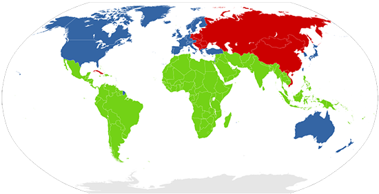
The concept of the Global North and the Global South is also an important one to think about geographically and geopolitically. Also an extension of Cold War geopolitics, the Brandt line (essentially the line that separates blue and red) shows the north-south divide. The Brandt line image below has been updated to include countries like South Africa, Singapore, and Taiwan. The Brandt line shows the more economically developed countries (MEDCs) in blue and the less economically developed countries (LEDCs) in red.

If you compare the two maps above, you’ll notice that the First and Second World comprise the Global North, while the non-aligned or the Third World countries comprise the Global South. The competition between the First and Second Worlds was not just ideological, but one that vied for non-aligned countries to choose their economic development trajectory: Capitalism or Communism.
Territory as Political Space
Two related ideas that connect to territory as political space:
- Territory requires some sort of political control.
- Politics, or the exercise of power, often requires territory.
As Flint explains, territoriality is the power exercised through the construction and management of territory.
The film clip “The Magnificent African Cake” you watched in the first section (Geography & Politics) of this lesson, illustrates the messiness of sovereignty claims that highlight the tensions around the concept of territory (and territoriality) on the African continent.
Lesson 5 will explore the geopolitics of territory more fully, but, for now, it’s important to understand that “(t)erritory is both a fundamental building-block of geopolitics and something that is fluid over time and varies across space.” (Flint, 2016, p. 34)
The Politics of Networks
Perhaps one of the most common ways people these days understand the concept of networks is to think of the many often-used social networks, like Facebook. While our book doesn't necessarily cover or include social networks in our discussion of geopolitics, it is interesting to think of the ways virtual spaces such as the Facebook networking platform facilitate the organization of individuals into groups of similar interests, political beliefs, etc. Furthermore, it is also interesting to observe the ways in which various terrorist organizations have recently used social networking practices such as hashtagging (#) to draw attention to their cause and intimidate.
To Read
Please read the following article before completing the blog assignment.
- (Read Pg. 7-12) The Cyber Longbow and Other Information Strategies: U.S. National Security and Cyberspace [5] by Gary D. Brown, In War in the 21st Century and Collected Works, 5 Penn State Journal of Law and International Affairs (2017). (pdf available in Canvas)
- Friis, S. M. (2015). 'Beyond anything we have ever seen': beheading videos and the visibility of violence in the war against ISIS. International Affairs 91(4), 725-746. (pdf available in Canvas) See author's abstract below:
This article examines the role of the Islamic State of Iraq and Syria's (ISIS's) beheading videos in the United Kingdom and the United States. These videos are highly illustrative demonstrations of the importance of visual imagery and visual media in contemporary warfare. By functioning as evidence in a political discourse constituting ISIS as an imminent, exceptional threat to the West, the videos have played an important role in the re-framing of the conflict in Iraq and Syria from a humanitarian crisis requiring a humanitarian response to a national security issue requiring a military response and intensified counterterrorism efforts. However, this article seeks to problematize the role and status of ISIS's beheadings in American and British security discourses by highlighting the depoliticizing aspects of reducing a complicated conflict to a fragmented visual icon. The article concludes by emphasizing the need for further attention to how the visibility of war, and the constitution of boundaries between which acts of violence are rendered visible and which are not, shape the political terrain in which decisions about war and peace are produced and legitimized. [ABSTRACT FROM AUTHOR]
We will go into further details on the politics of networks, but it is important to start thinking about the power of networks in your life and at multiple scales. Indeed, our political, social, cultural, religious, and economic networks fill (and perhaps fulfill) our daily interactions.
An Introduction to Geopolitics
Geopolitics (broadly the mutual construction of space and power relations) is both a matter of practice (doing) and representation (justifying the doing). - Colin Flint, Interview [6]
What is geopolitics?
- The connection between geopolitics and statesmanship: the “practices and representations of territorial strategies.” (p. 31)
- It is a way of “seeing” the world. (p. 40)
- It results from the identification of “situated knowledge”, or a nuanced understanding of “multiple practices and multiple representations of a wide variety of territories.” (p. 34)
- (Critical geopolitics) is the practice of identifying the power relationships within geopolitical statements. (p. 35)
Structure and Agency
As Flint explains (p. 43), there is an intellectual debate within the social sciences around the ideas of structure and agency. The textbook discusses some foundational definitions of agency and structure (pp. 43-44). If you need a refresher, please do re-read that section. Also, as a reminder, Flint provides some key rules to aid in our discussion of structure and agency. I repeat them below (p. 43):
- Agents cannot act freely, but they are able to make choices.
- Agents act within structures.
- Structures limit, or constrain, the possible actions of the agent.
- Structures also facilitate agents, in other words, they provide opportunities for agents to attain their goals.
- An agent can also be a structure and vice versa.
Agency is the actions behind trying to achieve a particular goal. Individuals or groups act, or have agency. Sometimes we can talk about states or a social movement having agency, but at other times it is more appropriate to think of groups or individuals at a lower scale (i.e., the President and the Pentagon acting differently to negotiate the defense budget). Agency is related to geopolitics in that it creates spaces (i.e., a nationalist group tries to create a nation-state) while actions are framed or situated within spaces.
Geopolitics, Power & Geography
Geopolitics, as the struggle over the control of spaces and places, focuses on power, or the ability to achieve particular goals in the face of opposition or alternatives. - (Flint, 2016, p. 45)
Flint reviews three forms of power important to the understanding of historic and contemporary geopolitical thinking: material, relational, and ideological power. In 19th and early 20th century geopolitical practices, power was seen as the relative power of countries in foreign affairs. In the 19th century, power was based on the size of a country, whereas in the 20th century, the study of geopolitical power became more academic as scholars created numerous indices of power focused on country-specific capabilities such as industrial strength, size, education level of the citizenry, as well as military capabilities. Power was based on a country’s material power or capacity to wage war.
Towards the latter half of the 20th century, discussions of power became more nuanced, sophisticated, and critical of seeing power as a thing that can be possessed. Rather, a relational sense of power came to greater prominence. As such, the “strong” power of one state was understood in relation to the “weak” position of another within a political network (i.e., the United Nations Security Council). In sum, geopolitical social relations create a framework that enables some actors to “force, cajole, or convince another actor to do what is wanted, or for that ‘acted-upon’ actor to resist, to varying degrees” (Flint, 2016, p.46).
Lastly, ideological power is “the ability or need not to force others to do what you want, but to make them follow your agenda willingly without considering alternatives” (Flint, 2016, p. 46). This analysis stems from Italian Marxist Antonio Gramsci’s writing which observed that a ruling class rarely has to exert force to control the working class. Instead, the normative structure which frames our everyday lives incentivizes the working class to behave in a certain “acceptable” or “normal” way while marginalizing and belittling alternative behaviors or structures as “radical”, “abnormal”, or “unnatural.”
Introductory Blog Post
Please visit the Lesson 1 Module in Canvas for a full description, including due date and submission instructions.
Summary and Final Tasks
Summary
Now that you've gone through Lesson 1 and completed the associated activities, you should be able to discuss the basic concepts of place, scale, structure, and agency. After completing the assignments for this lesson, you should now also better understand how places in the world (i.e., your hometown) are both unique and interconnected. Furthermore, current events (happening in your hometown and elsewhere) are not territorially isolated events, but occur within an interconnected set of scales. Lastly, you should be able to discuss how these current events are performed by geopolitical agents, as well as how the actions of these agents happen within various interconnected and overlapping structures. And, of course, you should be able to articulate the multiple forms of power that underlie geopolitics.
Reminder - Complete all of the Lesson 1 tasks!
You have reached the end of Lesson 1! Double-check the Lesson 1 module in Canvas to make sure you have completed all of the activities listed there before you begin Lesson 2.