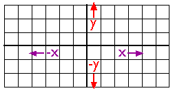
A Cartesian coordinate system.
As you probably know, locations on the Earth's surface are measured and represented in terms of coordinates. A coordinate is a set of two or more numbers that specifies the position of a point, line, or other geometric figure in relation to some reference system. The simplest system of this kind is a Cartesian coordinate system (named for the 17th century mathematician and philosopher René Descartes). A Cartesian coordinate system is simply a grid formed by juxtaposing two measurement scales, one horizontal (x) and one vertical (y). The point at which both x and y equal zero is called the origin of the coordinate system. In the illustration above, the origin (0,0) is located at the center of the grid. All other positions are specified relative to the origin. The coordinate of upper right-hand corner of the grid is (6,3). The lower left-hand corner is (-6,-3). If this is not clear, please ask for clarification!
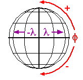
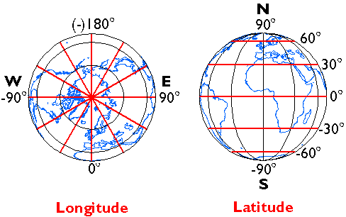
Cartesian and other two-dimensional (plane) coordinate systems are handy due to their simplicity. For obvious reasons they are not perfectly suited to specifying geospatial positions, however. The geographic coordinate system is designed specifically to define positions on the Earth's roughly-spherical surface. Instead of the two linear measurement scales x and y, the geographic coordinate systems juxtaposes two curved measurement scales. The east-west scale, called longitude (conventionally designated by the Greek symbol lambda), ranges from +180° to -180°. Because the Earth is round, +180° (or 180° E) and -180° (or 180° W) are the same grid line. That grid line is roughly the International Date Line, which has diversions that pass around some territories and island groups. Opposite the International Date Line is the prime meridian, the line of longitude defined by international treaty as 0°. The north-south scale, called latitude (designated by the Greek symbol phi), ranges from +90° (or 90° N) at the North pole to -90° (or 90° S) at the South pole. We'll take a closer look at the geographic coordinate system next.
The geographic (or "geodetic") coordinate system.
The geographic coordinate system.
Longitude specifies positions east and west as the angle between the prime meridian and a second meridian that intersects the point of interest. Longitude ranges from +180 (or 180° E) to -180° (or 180° W). 180° East and West longitude together form the International Date Line.
Latitude specifies positions north and south in terms of the angle subtended at the center of the Earth between two imaginary lines, one that intersects the equator and another that intersects the point of interest. Latitude ranges from +90° (or 90° N) at the North pole to -90° (or 90° S) at the South pole. A line of latitude is also known as a parallel.
At higher latitudes, the length of parallels decreases to zero at 90° North and South. Lines of longitude are not parallel, but converge toward the poles. Thus while a degree of longitude at the equator is equal to a distance of about 111 kilometers, that distance decreases to zero at the poles.
| Try This! |
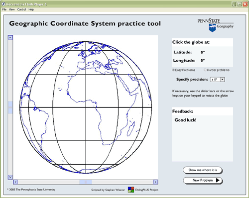
Geographic Coordinate System Practice ApplicationNearly everyone learned latitude and longitude as a kid. But how well do you understand the geographic coordinate system, really? My experience is that while everyone who enters this class has heard of latitude and longitude, only about half can point to the location on a map that is specified by a pair of geographic coordinates. The Flash application linked below lets you test your knowledge. The application asks you to click locations on a globe as specified by randomly generated geographic coordinates. You will notice that the application lets you choose between "easy problems" and "hard problems." Easy problems are those in which latitude and longitude coordinates are specified in 30° increments. Since the resolution of the graticule (the geographic coordinate system grid) used in the application is also 30°, the solution to every "easy" problem occurs at the intersection of a parallel and a meridian. The "easy" problems are good warm-ups. "Hard" problems specify coordinates in 1° increments. You have to interpolate positions between grid lines. You can consider yourself to have a good working knowledge of the geographic coordinate system if you can solve at least six "hard" problems consecutively and on the first click. Click here to download and launch the Geographic Coordinate System practice application (5.7 Mb). (If the globe doesn't appear after the Flash application has loaded, right-click and select "Play" from the pop-up menu.)
Note: You will need to have the Adobe Flash player installed in order to complete this exercise. If you do not already have the Flash player, you can download it for free at http://www.adobe.com/products/flash. |
 |
Students who register for this Penn State course gain access to assignments and instructor feedback, and earn academic credit. Information about Penn State's Online Geospatial Education programs is available at http://gis.e-education.psu.edu. |