Module 5.1: Soil Basics
Module 5.1: Soil Basics
Introduction
Overview of soils and nutrients for food production
In this course, we describe food systems as a coupling between human societies and natural earth systems and environments. This coupling is especially clear in the activities of food production that rely on crop and livestock raising. Crops and livestock production (and to a similar extent, fisheries, and aquaculture) require food producers to bring together human management with soil conditions and soil nutrients (this module), water (next module), as well as sunlight for energy and adequate climate conditions (temperature, humidity, adequate growing season). To understand these human-natural interactions across the entire course, and to build your capacity to understand natural factors as part of your capstone projects and other chapters of your education, this module describes basic soil properties and the role of soils in creating adequate conditions for crops to grow, which underlies most aspects of food production. It’s therefore very important that we understand soils as the “living skin of the earth” in their properties and history, the global patterns of soil fertility and soil limitations, and then its role in supplying nutrients to plants, and how soil fertility is regenerated by the human societies and management knowledge that allows them to continue supporting food production. Our goal is not to condense an entire course in soil science, although we hope that many of you will go on to take such a course. Rather, we want to sketch out major factors and determinants of the opportunities and limitations posed by soils to a human food production system.
What is Soil?
What is Soil?
We may be used to referring to soil as “dirt”, as in “my keys fell in the dirt somewhere” or “after planting the garden we had dirt all over our hands” but the way in which soil supports food production far more complex than a smear of clay on our hands. One way to define this difference in perspective is to think about the biological and chemical complexity in soil, and the fact that soils are not just brown, powdery handfuls of dirt but occupy a grand scale in the natural systems that underlie food systems. Soil is the "skin of the earth", layers that ascend from bedrock and supply water and nutrients to the fields and forests that make up the terrestrial biosphere. Soils are ecosystems in their own right, within mineral layers that form part of the earth’s surface. Soils can be as shallow as ten centimeters and as deep as many tens of meters.
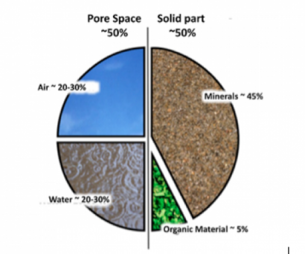
An interesting exercise is to think of a single term or concept that describes how soils work and what they are. For example, if we were seeking an acronym to describe soil and market it as the marvelous thing that it is1 —and if we lacked time to think of a catchier name – we might think up the acronym “PaBAMOM” which nevertheless is a pretty good summary of what soil is: a “Porous and Biologically Active Mineral-Organic Matrix”. It’s a good summary because it defines the unique properties of soils (see Figure 5.1.1 below):
- Porous (full of open spaces or pores), at a range of pore sizes from well below a micron (10-6 m or 0.0001 cm) to many centimeters, and therefore able to store water and transmit it to deeper earth layers, and host organisms as diverse as bacteria, plant roots, and prairie dogs. This porosity arises not only from the inherent sizes of particles in soil but is also a result of soil organisms and roots that generate aggregation of the soil from clay and silt particles into crumbs and clods that may be familiar to from typical garden soil. This biologically generated aggregation is sometimes referred to as structure, which is seen in figure 5.1.1 as the overall arrangement of pores and aggregates, and in the notion that soil is a matrix (point five below). The ideas of aggregation and structure will be revisited in this module and in module 7.
- Soil is phenomenally biologically active and biologically diverse, especially in microbes, which makes it able to perform many useful functions. For example, soil microbes are able to "recycle" or decompose materials like wood, wheat straw, and bean roots into energy for themselves and other soil biotas; various other types of microbes also draw or fix nitrogen out of the air to feed plants, detoxify the soil from organic pollutants, or perform myriad other beneficial services -- and other not so beneficial processes such as diseases.
- Soil is mineral, formed from the breakdown and chemical processing of the earth’s rock crust into sand, silt, and clay, each with its own ability to store water based on the size of pores they create and unique chemical roles in further processing and breakdown of soil materials. Usually, the mineral part is most of the solid (non-pore) part of soil (Figure 5.1, top pie chart)
- Soil is also organic, containing bits of organic (carbon-containing) remnants of plants and animals, some of which become stabilized until they last hundreds and even thousands of years as part of the soil. In the current efforts to promote carbon sequestration to alleviate (mitigate) climate change, it is worth noting that the amount of carbon stored in these bits of soil organic matter globally easily exceeds the total carbon stock in all of the planet’s forests.
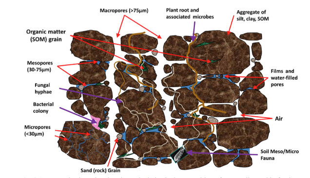
- Lastly, it is a matrix, which means that at least as important as the particles, aggregates, and pores of the soil are the organisms and processes that occur on and in these particles and pores (Fig. 3.1, bottom). This matrix hosts a highly complex ecosystem that winds its way through the millions of pores, roots, fungal hyphae, insects, and other organisms in soil. And here we are referring to the complex system concept we presented in module one: soil has many interacting parts with overlapping interactions, the ability to produce unexpectedly stable or unstable outcomes, and contains processes that can produce positive and negative feedbacks. One important example of this type of behavior is the range of soil productivity “behavior” of soils over time, including the ability of some soils to sustain moderate to high levels of productivity over years or decades (they resist change through processes of negative feedback), and then collapse in terms of food production as the interlocking, complex systems fueled by organic constituents and biological processes are dismantled (positive feedbacks operate to drive them towards degradation). Soils can then be similarly resilient in terms of remaining unproductive until the complex systems can be rebuilt through soil restoration practices.
So, soil is not dirt. It is porous and complex, it covers almost every land surface on the planet (ice caps, glaciers, and bare rock are exceptions), and it is a ubiquitous, critical resource that is heavily coupled to human societies for their food production and in need of protection. It’s not dirt, it’s a PaBAMOM!
1. We don’t have to do this marketing job (phew!) because the existence and value of soils are so often taken for granted. Recently, economists have been working on estimating the implicit worth of the services performed for society by a single hectare (100 m x 100 m) of soil, and the amounts can range into tens of thousands of dollars per year depending on soils’ properties and the way they are used.
Soils Support Plant Growth and Food Production
Soils Support Plant Growth and Food Production
Support, Water, and Nutrients
Before examining other basic soil functions, it is helpful and will avoid possible confusion, to understand the basics of how soils support the needs of crops, which in turn support the food needs of humans and their livestock. Firstly, soils provide a physical means of support and attachment for crops – analogous to the foundation of a house. Second, most water used by plants is drawn up through roots from the pores in soils that provide vital buffering of the water supply that arrives at crops either from rainstorms or applied as irrigation by humans. Third, as crops grow and build their many parts by photosynthesizing carbon out of the air (see module 6, next, for more on this) they gain most of the mineral nutrients they need (chemical elements) they need2 from soils, for example by taking up potassium or calcium that started out as part of primary minerals in earth’s crust, or nitrogen in organic matter that came originally from fertilizer or the earth’s atmosphere. The adaptation of crop plants domesticated by human farmers (and other plants) to soils, and the adaptation of the soil ecosystem to plants as their primary source of food mean that soils usually fulfill these roles admirably well.
2 The elements needed by plants other than Carbon (from the air) and Hydrogen/Oxygen (from water) in rough order of concentration are Potassium, Nitrogen, Phosphorus, Calcium, Magnesium, Sulfur, Iron, Manganese, Zinc, Boron, Copper, Molybdenum, and Cobalt (for some plants). Other elements are taken up into plants in a passive way without being essential, such as Sodium, Silicon, or Arsenic.
Soil Formation and Geography
Soil Formation and Geography
How do soils form in different places?
Soil Formation Factors
Soils around the world have different properties that affect their ability to supply nutrients and water to support food production, and these differences result from different factors that vary from place to place. For example, the age of a soil -- the time over which rainfall, plants, and microbes have been able to alter rocks in the earth's crust via weathering-- varies greatly, from just a few years where soil has been recently deposited by glaciers or rivers to millions of years in the Amazon or Congo River Basins. A soil's age plus the type of rock it is made from gives it different properties as a key resource for food systems. Knowing some basics of soil formation helps us to understand the soil resources that farmers use when they engage in food production. Below are some of the most important factors that contribute to creating a soil:
- Climate: climate has a big influence on soils over the long term because water from rain and warm temperatures will promote weathering, which is the dissolution of rock particles and liberating of nutrients that proceed in soils with the help of plant roots and microbes. Weathering requires rainfall and is initially a positive process that replenishes these solubilized nutrients in soils year after year and helps plants to access nutrients. However, over the long run (thousands to millions of years) and in rainy climates, rainwater passing through a soil (leaching) leaves acid-producing elements in the soil like aluminum and hydrogen ions and carries away more of the nutrients that foster a neutral pH (e.g. calcium, magnesium, potassium; see the next page on soil properties for a discussion on soil pH). Old soils in rainy areas, therefore, tend to be more acidic, while dry-region soils tend to be neutral or alkaline in pH. Acid soils can make it difficult for many crops to grow. Meanwhile, dry climate soils retain nutrients gained in weathering of rock -- a good thing -- but may lack plant cover because of dry conditions. A lack of plant cover leaves the soil unprotected from damage by soil erosion and means that dry climate soils often lack dead plant material (residues) to enrich the soil with organic matter. Both dry and wet climate soils have advantages as well as challenges that must be addressed by human knowledge in managing them well so that they are protected as valuable resources.
- Parent material: soils form through the gradual modification of an original raw material like rock, ash, or river sediments. The nature of this raw material is very important. Granite rock (magma that hardened under the earth) versus shale (old, compressed seabed sediments) produce very different soils. An important example of parent material influencing soils with consequences for human food production are soils made from limestone or calcium and magnesium carbonates. These rocks strongly resist the process of acidification by rainfall and leaching described above. Limestone soils maintain their neutral level of acidity (or pH) even after thousands of years of weathering, and thus can better maintain their productivity. An example of this parent material influence is the Great Valley in Pennsylvania, USA, where the Amish reside. These Pennsylvania soils are considered some of the most productive soils in the U.S. even after hundreds of years of farming. Pockets of other limestone soils the world over are similarly productive over the long term. In summary, as part of learning about a food production systems of a region, it can be helpful to consider the types of rock that occur in that region, which you may want to consider for your capstone regions.
- Soil age: the time that a soil has been exposed to weathering processes from climate, and the time over which vegetation has been able to contribute dead organic material, are important influences on a soil. Very young soils are often shallow and have little organic matter. In a rainy climate, young (e.g. 1000 years) to medium aged (e.g. 100,000 years) soils may be inherently very fertile because rainfall and weathering have not yet removed their nutrients. Old soils are usually deep and may be fertile or infertile depending on the parent material and long-term climatic conditions. Soils in previously glaciated regions such as the northern U.S. and Europe are usually thought of as young because glaciers recently (~10,000 years ago) left fresh sediments made from ground up rock materials.
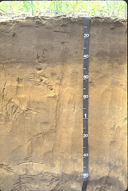
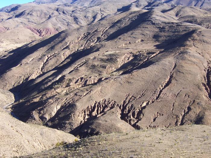
- Soil slopes, relief, and soil depth: Steep slopes in mountains and hilly regions cause soils to be eroded quickly by rainfall unless soils are covered by throughout the year by crops or forest. These hilly and mountain regions may also have young soils, and the combination of young soils and erosion can make for soils that are quite thin. Meanwhile, flat valley areas are where the eroded soil is likely to accumulate, so soils will be deep. Along with the water holding capacity and the nutrient content of a soil, soil depth determines how much soil "space" or soil volume a crop's roots can explore for nutrients and water. Soil depth is an important and often overlooked determinant of crop productivity of soils. Moreover, these large-scale "mountain versus valley" differences can be mirrored within a single field, with small differences in topography creating differences in drainage, depth, and other soil properties that dramatically affect soil productivity within ten to twenty meters distance.
A Summary of Soil Formation: The Global Soils Map
These four factors along with the vegetation, microbes, and animals at a site, create different types of soils the world over. A basic global mapping of these soil types is given below in Fig. 5.1.2 We've attached some soil taxonomic names (for soil orders, categories used by soil taxonomists) to these basic soil types for those who are familiar with some of the terminology of soil classification. We should emphasize that understanding these orders is not essential to your understanding of food production and food systems, as long as you understand how the basic processes of soil formation described above, and the properties of soils described on the next page, contribute to the overall productivity of a soil. You should think about how the soil formation processes affect crop production in your capstone regions of your final project, and you should be able to find resources on how soils were formed in any place in the United States and around the world.
Formation and Management Affect a Soil's Productivity
Another important point is that soil formation processes described above largely determine only the initial state of a soil as this passes into human management as part of a coupled human-natural food system. Human management can have equally large effects as soil formation on productivity, either upgrading productivity or destroying it. The best management protects the soil from erosion, replenishes its nutrients and organic matter, and in some ways continues the process of soil formation in a positive way. We'll describe these best practices as part of a systems approach to soil management in module 7. Inadequate human management can be said to "mine" the soil, only subtracting and never re-adding nutrients, and allowing rainfall and wind to carry away layers of topsoil.
The next page adds to this description of soil formation by focusing in on the basic properties that affect food production on soils, like acidity and pH which is discussed above.
Soil Properties and Human Responses to Boost Food Production
Soil Properties and Human Responses to Boost Food Production
Nutrients, pH, Soil Water, Erosion, and Salinization
In growing crops for food, farmers around the world deal with local soil properties that we started to describe on the previous page. These properties can either be a positive resource for crop production or limitations that are confronted using management methods carried out by farmers. The first of these, a soil's nutrient status, is described in more detail in module 5.2. Regarding nutrients is only important to emphasize here that most nutrients taken up by plants (other than CO2 gas) come to plant roots from the soil, and that the supply of these nutrients often has to do with the amount of dead plant remains, manure, or other organic matter that is returned to the soil by farmers, as well as fertilizers that are put into soils to directly boost crop growth. Here are the other major soil properties that farmers pay attention to in order to sustain the production of food and forage crops:
Soil pH or Acidity: Near Neutral is Best
Most crops prefer soils that have a pH between 5 and 8, mildly acidic to mildly alkaline (to understand these pH figures, remember that water solutions can be either acidic or basic (alkaline), and that pH 7 is neutral, vinegar has a pH of about 2.5, and baking soda in water creates a pH of about 8). As discussed above under the climate and parent material sections describing soil formation, soils in rainy regions tend to become more acidic over time.& Soils with too low a pH will have trouble growing abundant food or feed for animals. Farmers manage soils with low pH by adding ground up limestone (lime) and other basic (that is, acid-neutralizing) materials like wood ash to their soils. As an alternative, farmers sometimes adapt to soil pH by choosing or even creating crops or crop varieties that have adapted to low pH, acidic soils. For example, potatoes do well in high elevation, acidic soils of the Andes and other areas around the world. Alfalfa for livestock does better in neutral and alkaline soils while clovers for animal food grow better in more acidic soils.
Soil Water Holding Capacity and Drainage: Deep, Loamy, and Loose is Best
Module 4 described the importance of water for food production and the way that humans go to great lengths to provide irrigation water to crops in some regions. Soil properties also play a role in the amount of water that can be stored in soils (for days to weeks) that is then available to crops. A soil that holds more water for crops is more valuable to a farmer compared to a soil that runs out of water quickly. Among the properties that create water storage in soils is soil depth or thickness, where a deep soil is basically a larger water tank for plant roots to access than a thin soil. The proportions of fine particles (clay) versus coarse particles (sand) in a soil, called soil texture, also influence the water available to plants: Neither pure clay nor pure sand hold much plant-available water because clay holds the water too tightly in very small pores (less than 1 micron or 0.001 mm, or smaller than most bacteria) while sand drains too rapidly because of its large pores and leaves very little water. Therefore an even mix of sand, clay, and medium-sized silt particles hold the maximum amount of plant-available water. This soil type is known as loamy, which for many farmers is synonymous with “productive”. In addition to these soil properties, farmers try to maintain good soil structure (also called "tilth"), which is the aggregation of soil particles into crumb-like structures, that help to further increase the ability of soils to retain water. Soil aggregation or structure, and its multiple benefits for food production are further described in Module 7 on soil quality.
Clayey soils, and soils that have been compacted by livestock or farm machinery ("tight" vs. "loose" soils), can also have problems allowing enough water to drain through them (poor drainage), which can lead to an oversupply of water and a shortage of air in soil pores (refer back to figure 5.1.1 and the roughly equal proportion of air and water in pores of an agricultural soil). Too much water and too little air in a soil lead to low oxygen in the soil and an inability for roots and soil microbes to function in providing nutrients and water to plants. Part of good tilth, described above, is maintaining a loose structure of the soil.
In the face of these important soil properties for water storage, farmers seek out appropriate soils with sufficient moisture (e.g. deep and loamy, see Figs. 5.1.3 and 5.1.4) but also adequate drainage. Food producers also modify and maintain the moisture conditions of soils, through irrigation but also through maintaining good soil aggregation or tilth (see modules 5.2 and 7), and by avoiding compaction of soils that also leads to poor drainage and soils that are effectively shallower because roots cannot reach down through compacted soils to reach deeper water.
Salinization and Dry Climates: Hold the salt
Dry climate soils have less rainfall to leach them of minerals. They can, therefore, be high in nutrients, but also carry risks of harmful salts building up as rainfall does not carry these away either. Salt-affected soils may either be too salty to farm at all or may carry a risk that if irrigation water is too high in salts or applied in insufficient amounts to continually “re-rinse” the soil of salts, then salts can build up in soils until crops will not grow. The way that arid soils are managed is a key part of the human knowledge of food production in dry regions.
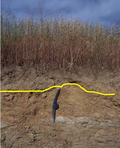
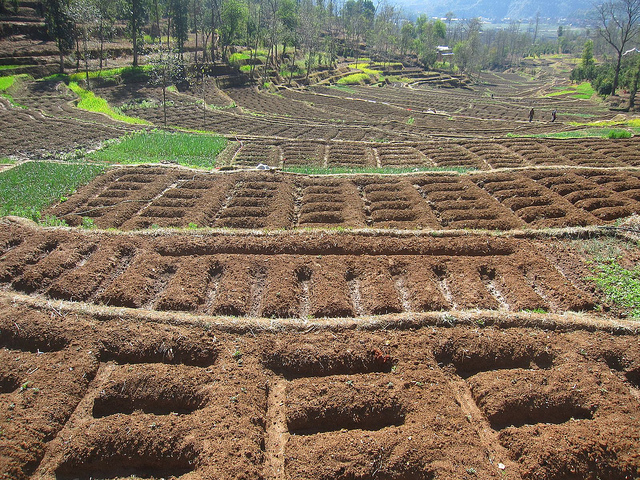
Relief and Erosion: Don't Let Soil Wash Down the Hill
Soil slope and relief are described on the previous page as creating higher risks of erosion (Fig. 5.1.5). To address this limitation food producers have either (a) not farmed vulnerable sloped land with annual crops, leaving them in the forest, tree crops, and year-round grass cover and other vegetation that holds soils on slopes; (b) built terraces and patterned their crops and field divisions along the contours of fields (Fig. 5.1.6). Terracing and terraced landscapes can be seen from Peru to Southeast Asia to Greece and Rwanda. Nevertheless, while sloped soils have been seen as the Achilles heel of environmental sustainability in mountain areas, the extreme elevation differences present in mountain areas can also be seen as a benefit to these food systems. The benefits arise because soils with very different elevation-determined climates and soil properties in close proximity, which allows for the production of a greater variety of crops. The simultaneous production in the same communities of cold- and acid soil tolerant bitter potatoes and heat-loving maize and sugar cane in lower, more neutral soils in the Peruvian Andes is an example of this benefit in high-relief mountain regions.
Soil Health: Understanding Soils as an Integrated Whole for Food Production
We hope that you are beginning to appreciate that appropriate management of soils is emphatically about integrating management principles like the ones presented here as human responses, along with an understanding of the basic properties of soils, and also the nutrient flows presented next in module 5.2. Soils are very much a complex system, and managing them for food production and environmental sustainability means that we must understand the multiple components and interactions of this system. The way in which this is accomplished has been summarized as the concept of Soil Health, which involves multiple components that are more fully addressed in module 7. Soil health is an aspiration of effective management and means that management has maintained or promoted properties like nutrient availability, beneficial physical structure, and diversity of functionally important and 'health-promoting' microbes and fauna in soils along with sufficient organic matter to feed the soil ecosystem. These integrated properties then allow production to avoid soil degradation, produce sufficient amount of food and livelihoods, and preserve biodiversity in soils as well as other significant ecosystem services like buffering of river flows and storage of carbon from the atmosphere.
3 This is not always true; Molybdenum, Sulfur, Boron and other micronutrients are sometimes found to limit plants, but the complexity of analyzing these is beyond the scope of this survey course.
Understanding Soil Maps at a Broad Global Level
Understanding Soil Maps at a Broad Global Level
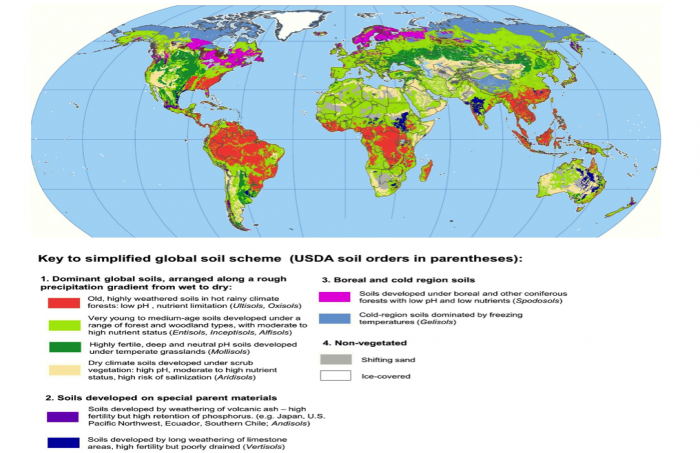
Soil scientists have done an enormous amount of work in mapping the patterns of soil at a global level. The most current and detailed effort comes out of mapping work from the Food and Agriculture Organization of the United Nations, now an independent agency that is known as the International Soil Resource Information Centre (ISRIC), and is based on classifying a set of diagnostic types of topsoil layers that occur in different climates, landscape ages, and vegetation types. The details of this system5 are beyond the scope of this course, however, and to summarize the introduction to global soil fertility in this unit we present a simplified version of the United States Department of Agriculture (USDA) system that is still in wide use by soils practitioners in the United States. The USDA system lines up very well with the ISRIC system at this simplified level and allows understanding of the broad strokes of soil nutrient geography in the way we have presented it (Figure 3.8).
This simplified map is intended to serve as a resource for your other learning in the course on how food systems may respond to the opportunities and limitations of soils, and also summarizes the learning in this module about how soils result from an interaction of parent material, time, climate, vegetation, and other factors. For example, you’ll notice that just four very broad summarized types (See section 1 of the soils key, “Dominant global soils” in Fig. 3.8) cover the vast majority of the earth’s surface, and can be organized into a rough typology of precipitation from wet to dry, along with their age and vegetation types (e.g. tropical and subtropical forests; other forest types; grasslands, and desert vegetation). Soils formed by temperate grasslands have been hugely important in recent history because once humans developed steel plows that were sufficiently strong to til prairie soils, these Mollisols could be farmed and became the breadbaskets of the modern era (e.g. the U.S. and Canadian Great Plains, the Ukraine, the Argentinian pampas). There are also small pockets of soils globally that depend strongly on their original parent material. Andisols or volcanic ash soils are an excellent example of this: although their global extent is minuscule and even invisible on our map (Fig. 3.8) at this scale, they often occur in areas with high population densities such as Ecuador, Japan, and Rwanda. The high densities of population are not an accident but occur exactly because these soils have high fertility potential and have become extremely important in these local food systems. The simplified global soils map is also a way to spatially conceptualize a number of key limiting factors in soils that food producers must face: acidic, P-retaining soils in highly weathered tropical and subtropical soils, P retention in volcanic soils, and the risk of salinization of soil in dry climate soils.
In addition, it is worth noting that the broad swaths of soil of young to moderate age and with moderate to high fertility (light green in our map) may be the dominant type of soil in the world and also includes many areas that are critical in terms of the sustainability outcomes for human-natural systems in relation to soils. Because these tend to be “medium-everything” soils (medium age, medium fertility, medium depth, medium pH, medium moisture, etc.) they do not actively dissuade human systems from occupying them with high population densities or intensity of management and production, especially as the global population increases. However these soils are often easily degraded, and so sustainable methods are especially important to guarantee future food production.
Finding out information on soils using the soil order suffix in the name of the soil according to the USDA soil taxonomy system.
Soil taxonomy is an enormous classification system that can initially be confusing. But knowing the first level of classification can be very useful, just like knowing whether an animal is a whale or a beetle is extremely helpful compared to not knowing anything. To classify soils broadly as to their limitations and productive potential, we can use the soil orders of the USDA system (see the order names in parentheses, in Fig. 3.8).
The key below will help you to use the last few letters of a USDA soil name, along with the ISRIC world soil mapping resource to query what types of soil are present around the world or specifically in your capstone regions. The categories are the same as what is presented in Figure 3.3, and you can use the query function in the ISRIC world soil mapper to find out what USDA soil names are present in each area, and draw conclusions about the potential fertility and properties of the soils at a broad level.
First, see the ISRIC resource is at SoilGrids [3]. This was also used in the formative assessment for Module 3.1.
In the ISRIC mapper you will need to click on layers icon in upper right and set the layer to “Soil Taxonomy: TAXOUSDA” and select the “All TAXOUSDA subclasses” -- when you query the map using a right click of the mouse, you’ll get a percent breakdown of the different soil orders at that location.
| Soil name ending | Meanings | Example |
|---|---|---|
| -Epts -Ents -Alfs |
Entisols : soils of recent deposition, no soil development.
Inceptisols: the beginning of soil formation – medium to high fertility soils Alfisols: broad class of medium age, medium to high fertility soils |
Glossoboric hapludalfs
Orthents |
| -Ols | Mollisols: prairie soils, high organic matter, generally neutral pH, fertile, deep | Dystric haplustolls |
| -Ids | Aridisols – dry region soils, generally high pH | Argids |
| -Ods | Spodosols – coniferous forest soils with acid needle litter leaching features | Orthods |
| -Ults -Oxes |
Ultisols – warm region, old, leached soils
Oxisols – oldest tropical soils formed only of weathering remnants, metal oxides |
Udults |
| -Ands | Andisols- volcanic ash soils | Vitrands |
| -Erts | Vertisols – highly weathered limestone, with shrink-swell clays. | Uderts |
5 Nevertheless, you may peruse this impressive global resource and the soil horizon definitions at ISRIC [4].
Formative Assessment: Mapping Trends in Soil Properties
Formative Assessment: Mapping Trends in Soil Properties
Instructions
You will complete an activity on mapping trends in soil properties using an online soil mapping resource. The emergence of tools such as this to visualize global and national soil data easily and with full public access is revolutionizing information about soils and management constraints in different regions of the world. Please download the worksheet so that you can fill it in (either on paper or preferably just by writing in your responses in MS Word).
The two web resources you will need for this worksheet are placed here so you can access them while you fill in the worksheet.
Mainly you will need the International Soil Resource Information Centre's soil mapping resource of the world, Soil [3]Grids [3]. Click past the intro window that will appear in the center of the screen and then pan the map to the area of interest as identified in the worksheet.
This is a mapping portal that resembles google earth - you have the ability to pan, zoom in, drag the map with the cursor and mouse (Fig. 5.1.7). When you enter you should see a toolbar in the top right corner. More instructions on the portal are given on the formative assessment worksheet.
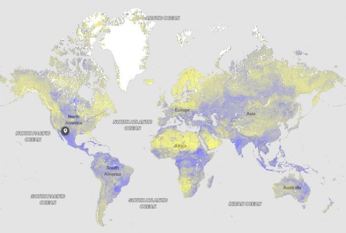
You will also need briefly, this online map showing global annual total precipitation [5].
Files to Download
Download the Worksheet [6] to complete your assessment.
Submitting your assignment
Please submit your assignment in Module 5 Formative Assessment in Canvas.