Module 7 - Urban Planning
Introduction
About Module 7
Module 7 begins with the concept of urban landscapes and then looks at different aspects of urban development with an emphasis on transportation and urban design. These two topics are important to study together because of how closely interconnected they are. The designs of the urban areas we live in influence our choices of transportation. Likewise, our tastes for transportation influence the designs of our urban areas. And both transportation and urban design have large impacts on the environment. Next, the module briefly reviews the environmental impacts of urban form focusing on a few major contributors. Following the discussion of urban environmental problems, the module ends with an examination of what cities can do to become more sustainable and resilient with real-world examples.
What will we learn in Module 7?
By the end of Module 7, you should be able to:
- define the concept of an urban landscape, and discuss the role that landscape plays in major world cities;
- explain the connection between urban design and transportation, in particular for pedestrian-oriented neighborhoods, streetcar suburbs, and automobile suburbs;
- discuss the environmental impacts of urban form;
- know the representative examples of sustainable urban development;
- explain the challenge of transitioning to new states, in particular sustainable states, including the transition of physical infrastructure and the transition of our minds.
As you read through this module, look for ways that these key concepts are integrated in the topics we will cover here as well as previous modules.
What is due for Module 7?
There is a Written Assignment associated with Module 7. For assignment due date, check Canvas.
| Requirement | Location | Submitting Your Work |
|---|---|---|
| Reading Assignment: Liberating Cities from Cars | Urban Design and Transportation | No submission |
| Written Assignment: Sustainable Cities | Written Assignments [1] | Submit in Canvas |
Questions?
If you have any questions, please post them to our Course Q & A discussion forum in Canvas. I will check that discussion forum often to respond. While you are there, feel free to post your own responses if you, too, are able to help out a classmate. If you have a more specific concern, please send me a message through Inbox in Canvas.
Urban Landscapes
Urban Landscapes
In Module 2, we learned that in geography landscapes are defined as the combination of environmental and human phenomena that coexist together in a particular place on Earth's surface. Urban areas are some of the most striking examples of human-environment landscapes. They involve the highest levels of human activity and are often heavily shaped by environmental factors.
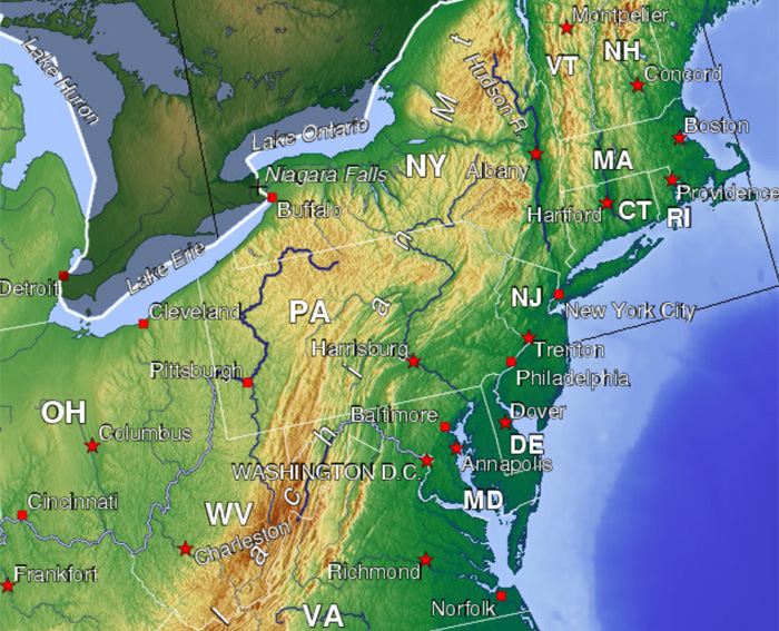
Let’s start by examining New York City, the largest city in the United States and one of the largest cities in the world. (Tokyo is usually considered to be the world’s largest city.)
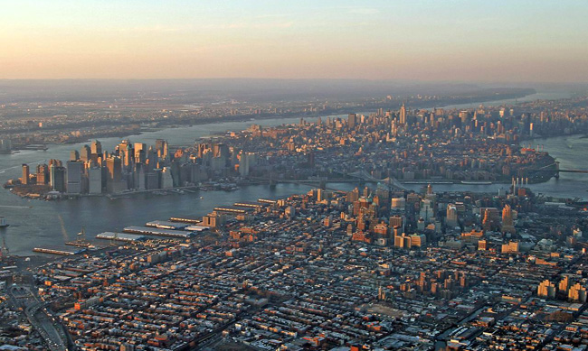
The landmass at the center of Figure 7.1 is the island of Manhattan. The Hudson River is towards the top and the East River is towards the bottom. The left edge shows the Hudson and East Rivers converging at New York Harbor. Across the Hudson from Manhattan is New Jersey. Across the East River is Brooklyn, which is on the tip of Long Island.
New York Harbor is one of the best natural ports in the world. Ships of all sizes can enter a space largely free from oceanic turbulence and dock along a remarkably long total length of coast. New York City emerged as an important port town in colonial times and remains a shipping center to this day, as can be seen from the rectangular shipping facilities protruding out into the rivers in various places. As the island located in the center of the navigable space, Manhattan emerged as the center of development within what is now the New York City metropolitan area.
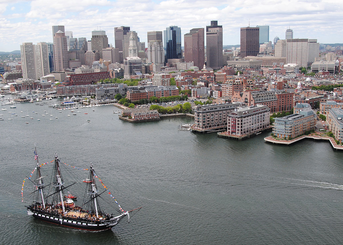
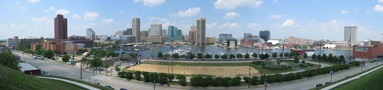
There are other great harbors along the eastern coast of the United States, such as Boston Harbor and Baltimore Harbor:
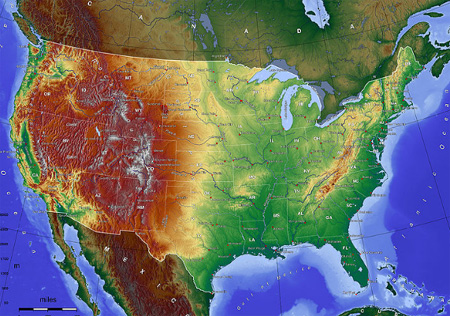
It is no coincidence that all three of these excellent natural harbors became major US cities. Their environmental advantages over other locations initiated development that persists to this day. There is an environmental explanation for why New York ended up becoming the largest city in the United States instead of Boston or Baltimore. To see it, we need to observe the environment at a broader scale. Take a close look at the eastern part of this topographic map (Figure 7.4), and be sure to "Click to Enlarge East Coast":
Note the Appalachian Mountains running continuously from Georgia through Maine (and beyond into Canada) with one major exception: the route from New York City north along the Hudson to Albany and then west between the Catskills in southeastern New York and the Adirondacks in northern New York. The Hudson is a very wide river and remains navigable through Albany. In the 1800s, the Erie Canal was built in the corridor between the Catskills and Adirondacks. This connected the east coast with the Great Lakes and, in turn, the interior of the country. New York City thus became the center of trade between the US interior and the rest of the world. As the interior grew in importance, so did New York.
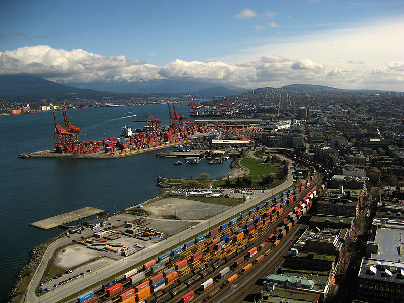
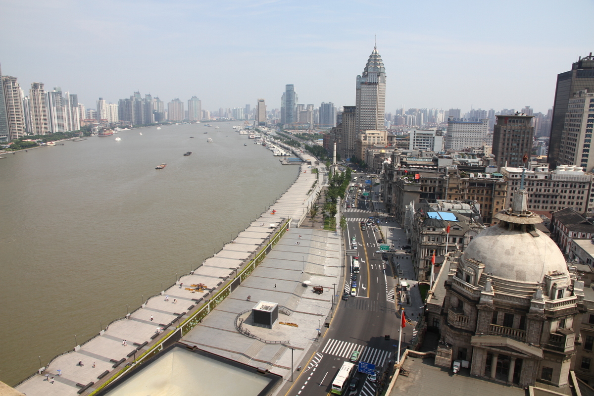
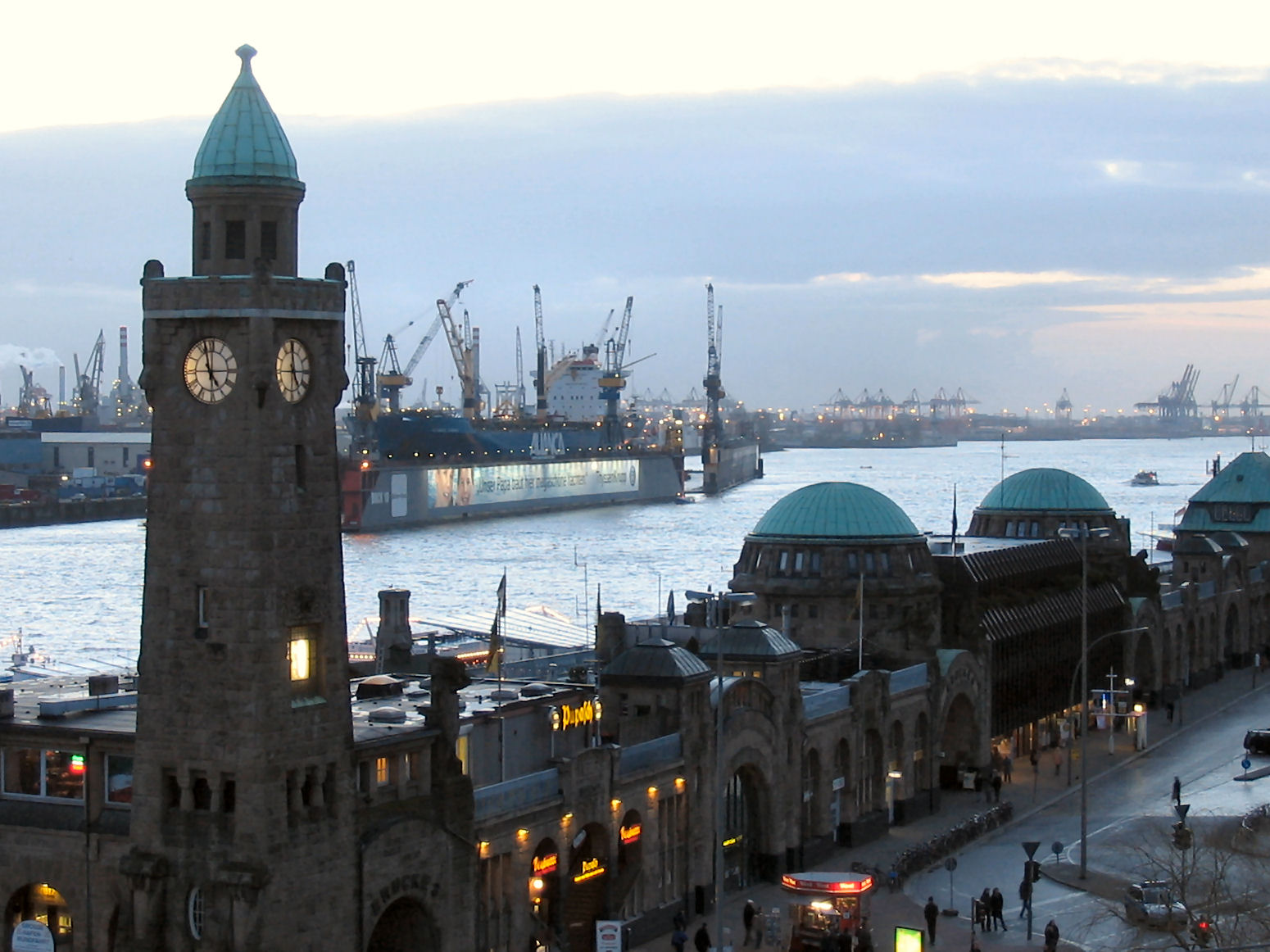
Many other important world cities emerged because their excellent natural harbors were used for ports. Here are some examples.
Vancouver, BC Canada
Shanghai, China
Hamburg, Germany
Rio de Janeiro, Brazil
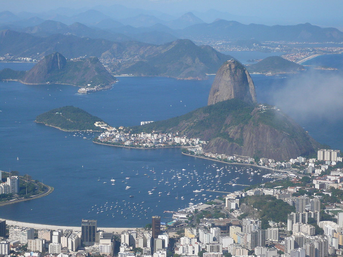
Rio de Janeiro has one of the most spectacular urban landscapes in the world. Figure 7.8 shows a beachfront lined with tall buildings at the mouth of the Guanabara Bay. The Atlantic Ocean is just to the right of the image. The large, steep mountain in the middle is Sugarloaf Mountain (Portuguese: Pão de Açúcar). Rio de Janeiro was founded by the Portuguese and became an important port for trade with Brazil’s interior. Figure 7.9 offers another view of the city:
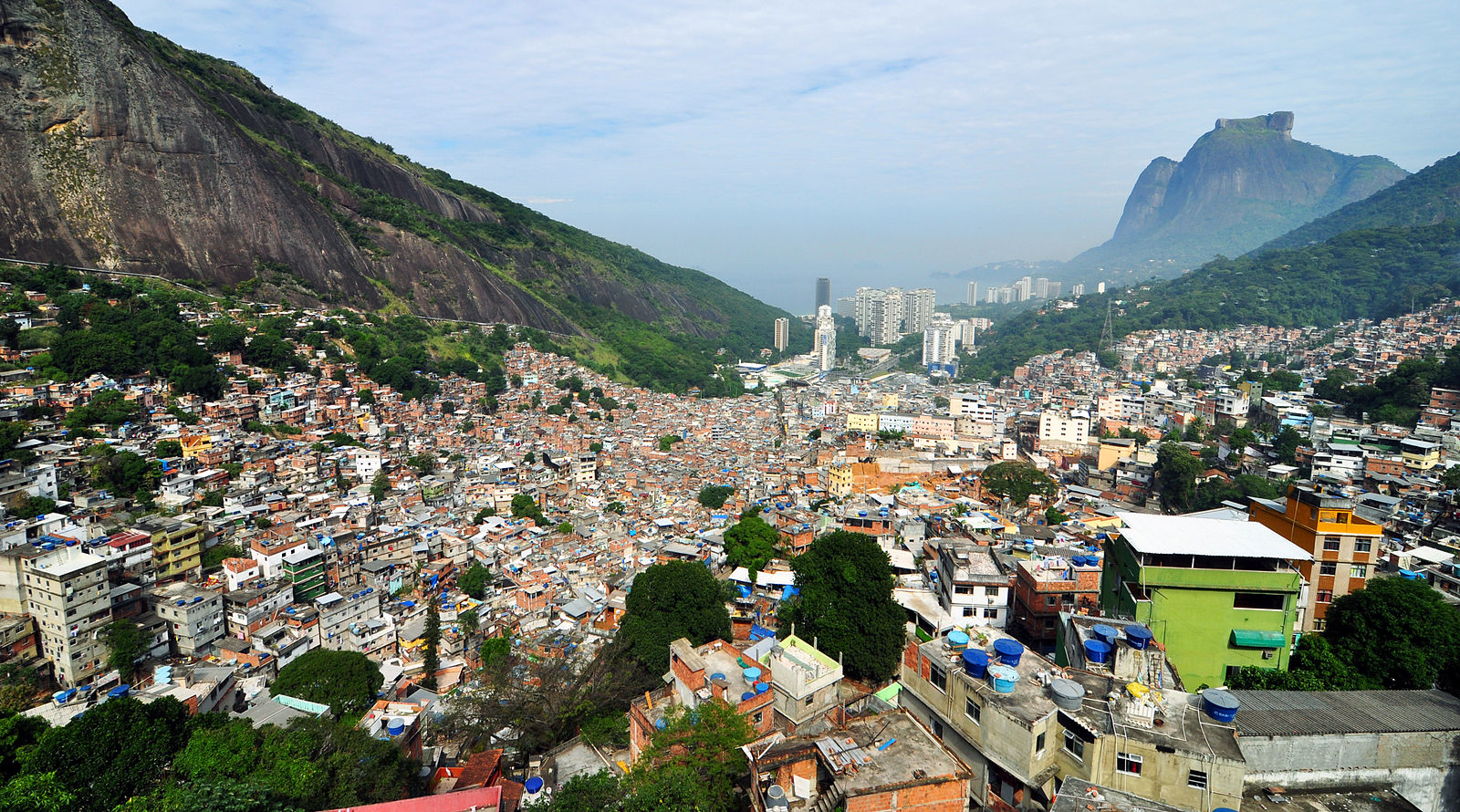
This image looks towards the Atlantic coast. It shows several mountains and some tall buildings along the coast. In the foreground is a dense collection of smaller buildings draping a hillside. This hillside area is Rocinha, the largest favela (slum) in Rio de Janeiro and one of the largest in the world. Slums are often located on hillsides where building conditions are weaker and access to the center city is worse. If you look carefully at Figure 7.9 (zoom in on the full-size image of Rocinha [16]), you’ll see many buildings in Rocinha in which the upper floors are architecturally different than the lower floors. These upper floors are simply tacked on top of the lower floors in an ad hoc fashion. All this renders Rocinha and other hillside favelas vulnerable to mudslides. The favela mudslides in Rio de Janeiro raise environmental justice issues similar to those discussed in the Module 5 section on development's downsides.
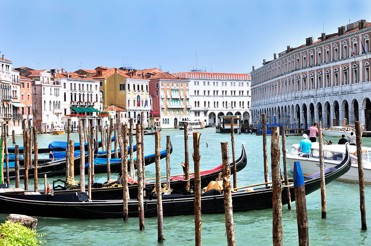
Venice, Italy
Another urban landscape heavily defined by water is Venice, Italy. Venice is noteworthy for being entirely car-free. All travel is via either walking or boats.
Urban landscapes may appear to be dominated by human activity. As the images in this page show, the environment is often a major factor in urban form. For example, the locations of natural harbors affect where major port cities end up. But human factors still play major roles. The human role is especially vivid in cities that were built from scratch in order to serve as a political capital, including Washington in the United States, Brasilia in Brazil, Abuja in Nigeria, Canberra in Australia, and Islamabad in Pakistan. These cities emerged as they did largely for social reasons instead of environmental reasons. For example, the location for Washington was chosen to be between the political north and south. When examining an urban landscape, it is important to consider both environmental and social factors and to recognize that cities are parts of human-environment systems.
For the remainder of this module, we’ll focus on a few aspects of cities that are of great importance to sustainability.
Urban Design and Transportation
Urban Design and Transportation
Why are there cities? Why do large numbers of people cluster near each other? Sometimes the reasons are predominantly environmental, such as the people who cluster at natural harbors to work at ports. Other times, the reasons are predominantly social, such as the people who cluster at political capitals to work in government. But whatever the reason, cities invariably exist so that people can interact with each other in person. Interacting with each other in person requires transportation. We travel from home to work, shopping, entertainment, and civic spaces.
Transportation is, thus, fundamental to the proper functioning of a city. A city is more likely to succeed when people can get around town easily, quickly, inexpensively, and safely. Transportation is important to cities, but cities are also important to transportation. Indeed, our transportation choices are heavily influenced by urban design. To see this, we’re going to look at three types of neighborhoods: pedestrian-oriented neighborhoods, streetcar suburbs, and automobile suburbs.
Reading Assignment: Liberating Cities from Cars
Please read the article "Liberating Cities from Cars [19]" on the Planetizen website.
As you read this, think about your answers to the questions below:
- What are some potential benefits of fewer cars on city streets?
- What are some typical components of reducing cars on streets?
- What are some challenges to the implementation of such car-reducing strategies?
Pedestrian-Oriented Neighborhoods
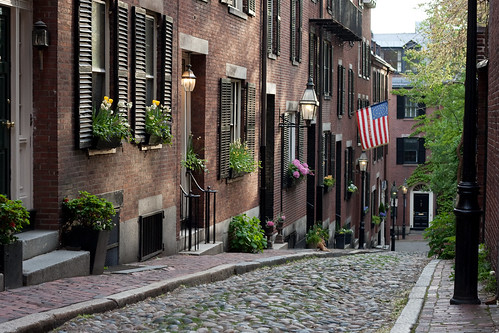
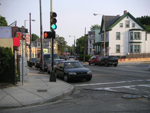
Let’s start by looking at Acorn Street on Beacon Hill in Boston:
Beacon Hill is just north of Boston Common, which we studied in Module 4. It is, thus, immediately adjacent to downtown Boston, where there are many places to work, shop, and seek entertainment, among other things. One can easily walk to all of these places. But look at the photo. This urban area is also designed in a way that makes walking easy and desirable. Beacon Hill was developed mostly in the 1800s when walking was the transportation mode of choice. Today, Beacon Hill is a very wealthy neighborhood. Many people there can afford cars, but they often choose not to use them because walking is a more attractive option.
Streetcar Suburbs
Now take a look at another part of Boston: Jamaica Plain.
This image shows Centre Street in Jamaica Plain, about four miles southwest of Beacon Hill and downtown Boston. Notice the rail line going through the middle of the street. This is for a streetcar – the “E” on Boston’s Green Line. This type of neighborhood is called a streetcar suburb because it was designed for residents to commute into the city via streetcar. Similar streetcar suburb neighborhoods exist in many cities across the United States. These neighborhoods were built mainly in the early 1900s. They are more sparse than neighborhoods built mainly for pedestrian travel, but they are dense enough to keep houses within walking distance of streetcar stops. Likewise, they’ll almost always have sidewalks. There are often small “main street” style stores near the streetcar stops. People might shop at these stores on their way to or from work.
As an interesting side note, the E no longer goes through this part of Jamaica Plain. In 1985, it was “temporarily” replaced by a bus line. Whether to bring the E back here is a controversial issue in the neighborhood. Elsewhere in the country, many streetcar systems have been dismantled. In at least some cases, the automobile and bus industry appears to have played a role in the change. Today, bus lines often run where streetcar lines once did, though many people in streetcar suburbs frequently use automobiles. The choice between cars and public transit is a collective action problem.
Automobile Suburbs
Now let’s switch over to another city, Rochester, NY. As with Boston, Rochester has a variety of neighborhoods that feature a variety of appearances. Here is one neighborhood towards the outer edge of the city:
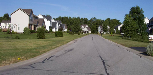
This image shows an example of an automobile suburb. Automobile suburbs are neighborhoods designed for residents to commute into the city via automobile. As can be seen from the photograph, these neighborhoods are sparser than neighborhoods designed for walking or for streetcar transit. These neighborhoods often have no sidewalks because they are built with the assumption that people will not walk along the streets. Furthermore, offices, shopping and other destinations will often be in separate areas that are difficult to access without a car. For these reasons, almost all trips in automobile suburbs are made via car.
As the above discussion suggests, where we live has a large impact on what type of transportation we use. If we live in a pedestrian-oriented neighborhood like Beacon Hill, we’re a lot more likely to walk to get to places nearby and to take transit to go further away. If we live in a streetcar suburb, we’re likely to use a mixture of transit, walking, and cars. If we live in an automobile suburb, we’ll probably take cars almost everywhere we go. Two main factors in the impact of urban design on transportation choice are urban density and use mixture.
Urban Density and Use Mixture
Urban density is, in rough terms, the amount of urban development per unit area. Higher density can be achieved via taller buildings and narrower streets. It can also be achieved by putting more development in a given square foot of floor space, sidewalk space, etc. For example, when a single-family house is converted into two apartments for two families, urban density is increased with only minor tweaks to the building. Pedestrian-oriented neighborhoods tend to be higher density, and automobile suburbs tend to be lower density. Higher densities generally have lower environmental impacts, though there are some exceptions. For example, shorter buildings don’t require elevators.
Use mixture refers to the mix of types of end uses found within an urban area. A mixed-use area will have many different uses. Residences, office areas, shopping, entertainment, and the government will all be close together. This reduces the distances required for transportation and makes it easier to walk or bike from place to place. It can also help certain types of businesses. For example, many downtown business districts are very single-use areas and restaurants there are only open for lunch. In some cases, apartment buildings are opening up in the area, which helps more people walk to work and also brings customers to the restaurants at different hours. Pedestrian-oriented neighborhoods tend to be more mixed-use, and automobile suburbs tend to be more single-use. In general, mixed-use areas will have lower environmental impacts than single-use areas.
Resident Health
The health of people living in cities is affected by many factors. One important factor is the amount of exercise that they get. This, in turn, can be heavily influenced by urban design. When we drive everywhere, we don’t get any exercise unless we go out of our way for it. When we walk and bike everywhere, we get a lot of exercise just by getting around town. This is much healthier for our bodies. Even taking transit gives us some exercise because we have to walk to and from the transit stops. It is thus no surprise that people who live in pedestrian-oriented neighborhoods and streetcar suburbs are on average healthier than people who live in automobile suburbs. Of course, the urban environment does not completely determine what exercise we get. It’s entirely possible to be very healthy in an automobile suburb or very unhealthy in a pedestrian-oriented neighborhood. But promoting resident health is another reason to favor high-density, mixed-use, pedestrian-oriented development.
The Ugly Side of Urban Design
“Urban segregation is not a frozen status quo, but rather a ceaseless social war in which the state intervenes regularly in the name of “progress,” “beautification” and even “social justice for the poor” to redraw spatial boundaries to the advantage of landowners, foreign investors, elite homeowners, and middle-class commuters” (Mike Davis, 2006, Planet of the Slums, p. 98)
Many of the ways that cities have been planned contribute to inequities such as educational quality and occupational opportunity. Well-known federal policies such as redlining and Jim Crow laws may no longer be legal, but the effects of these segregationist practices endure in cities today, impacting various dimensions of life including access to quality education, economic prospects, and good health. And while these overtly racist policies no longer exist, other less-obvious practices still contribute to differential access to resources, the built environment, and social opportunities within cities and their suburbs. As you read the following material, consider the cities you know and think about the different opportunities that residents might have based on where they live within those cities. Social inequalities in metropolitan areas stem from past as well as continuing practices that determine where and what types of roadways and transit opportunities are implemented or improved, assign specific uses (e.g. industrial, commercial, or single family or multi-family residential) to certain neighborhoods, and influence where parks and greenways get built or streetscapes maintained.
Jim Crow Laws & Residential Covenants
From the time of reconstruction after the U.S. Civil War until 1968, Jim Crow Laws in the Southern United States enforced racial segregation in places such as parks, public transit, and schools, among many other places. While Jim Crow laws were enacted in Southern states, residential covenants in other states kept people of color from moving into certain neighborhoods. For example, in Minneapolis one of the city’s first segregated residential areas stated that residences “shall not at any time be conveyed, mortgaged, or leased to any person or persons of Chinese, Japanese, Moorish, Turkish, Negro, Mongolian, or African blood or descent.”
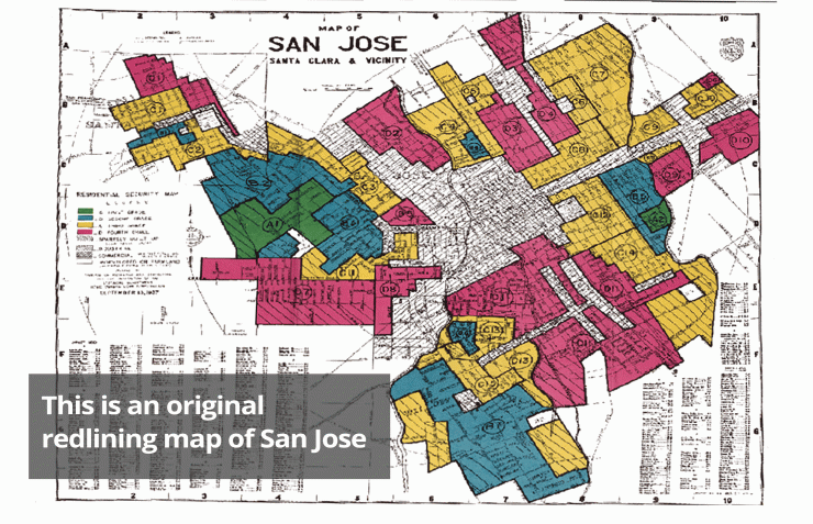
Red Lining
Beginning in the 1930s, the U.S. government, through the Home Owners Loan Corp (HOLC), the Federal Housing Administration (FHA), and the Veterans Administration (VA), created color-coded maps for every metropolitan area in the United States. These maps divided cities into areas based on the risk of making loans and assigned colors for risk, with red being “hazardous.” Areas where African-Americans lived were systematically marked red and deemed too risky to insure for mortgages. Additionally, the FHA openly argued in their Underwriting Manual that racial groups should not be integrated, even stating that highways would serve as a good barrier for keeping white and Black communities separated.
Legacies of exclusion still persist from Jim Crow Laws, racially-based covenants, and redlining. These practices of the past continue to impact opportunities for people of color of today. Please watch this short, seven-minute video on housing segregation and some of the impacts past policies have on access to resources today.
Required video: Housing Segregation and Redlining in America: A Short History, NPR Code Switch (6:36 minutes)
Chris Rock: You know what's so sad, man? You know what's wild? Martin Luther King stood for nonviolence. Now what's Martin Luther King? A street. And I don't give a f*** where you at in America, If you on Martin Luther King Boulevard there's some violence going down.
Gene: That, of course, is Chris Rock’s famous joke about streets named for Martin Luther King Jr., which tend to be in -- let's say distressed areas. And he’s not wrong, because if you look at the way housing segregation works in America you can see how things ended up this way. Once you see it, you won't be able to unsee it. OK, let’s look at MLK Boulevard in Baltimore. I want to show you how to see housing segregation in schools, in health, in family wealth, in policing. But first, an explanatory comma.
It’s the 1930s in the wake of the Great Depression. FDR is president. He wants to bring economic relief to millions of Americans through a collection of federal programs and projects called The New Deal.
One part of that "new deal" was The National Housing Act of 1934, which introduced ideas like the 30-year mortgage and low, fixed interest rates. So now you have all these lower-income people who can afford homes, but how do you make sure they don't default on their new mortgages? Enter the Home Owners Loan Corp. The HOLC created residential security maps. And these maps? They're where the term redlining comes from. Green meant “best area, best people,” aka businessmen; blue meant “good people,” like white-collar families; yellow meant a “declining area,” with working class families; and red meant “detrimental influences, hazardous," like “foreign-born” people, “low-class whites," and -- most significantly -- “Negroes.” Again and again on these HOLC maps, one of the most consistent criteria for redlined neighborhoods is the presence of black and brown people.
Let’s be clear. Studies show that people who lived in redlined areas were not necessarily more likely to default on their mortgages. But redlining made it difficult — if not impossible — to buy or refinance. So landlords abandon their properties. City services become unreliable. In most places, crime increases. And property values drop. All of these conditions fester for 30 years as white people flee to the brand new suburbs popping up all over the country. Many of those suburbs institute rules, called covenants, that explicitly forbid selling homes to black people. And all of this was perfectly legal.
Now it’s 1968. And MLK is assassinated. News Report: Good evening. The Rev. Dr. Martin Luther King, 39 years old, The apostle of nonviolence in the civil rights movement has been shot to death in Memphis, Tenn. Martin Luther King was shot and was killed tonight in Memphis, Tenn. In the aftermath, Congress passes the Fair Housing Act of 1968. It's a policy meant to encourage equal housing opportunities regardless of race, or religion or national origin. And it offers protections for future homeowners and renters, but does little to fix the damage already done.
Over the next 50 years, the Fair Housing Act is rarely enforced. So you can still see housing segregation and its effects, in Baltimore and often along any MLK Boulevard in any U.S. city. Like its effects on wealth. So homeownership is the major way Americans create wealth, right? Well, discrimination in housing is the major reason that black families up and down the income scale have a tiny fraction of the family wealth that white families do -- even white families with less education and lower incomes. For almost 30 years, 98 percent of FHA loans were handed out to white borrowers. Not only were black neighborhoods redlined, and not only was the Fair Housing Act selectively enforced, if at all, but it is still today much harder for a black person to get a mortgage or home loan than it is for a white person.
John: Families are fearful of speaking up about a basic human right that should be afforded to everyone in the world but definitely in the richest country in the world. And housing segregation in schools. The primary way that Americans pay for public schools is by paying property taxes. People who live in more valuable homes have better-funded local schools, better-paid teachers, better school facilities and more resources.
Here’s a feedback loop: The better the schools in a neighborhood, the more those homes in that neighborhood are worth. And the higher the property values of those homes, the more money there is for schools. And so on and so on. And housing segregation in health. Because of urban planning that benefited those richer, whiter neighborhoods, people of color are more likely to live near industrial plants that spew toxic fumes; they're more likely to live far away from grocery stores with fresh food, and in places where the water isn’t drinkable. They're more likely to live in neighborhoods with crumbling infrastructure, and in homes with toxic paint.
Karen: When you're living with rats, roaches, and things like that -- that's deplorable. You cannot have that kind of stuff with children running around in the building. A building that may be full of lead. And, not coincidentally, people of color have higher incidences of certain cancers, asthma and heart disease.
And housing segregation in policing.Housing segregation means we are having vastly different experiences with crime and vastly different experiences with policing. Because our neighborhoods are so segregated, sometimes racial profiling can be camouflaged as spatial profiling — where living in certain areas can make you more likely to be stopped by the police. And it means people have a lot of unnecessary contact with the criminal justice system just because of where they live.
Reggie: The problem in our city? The police and the citizens are fighting. They keep targeting my brothers and sisters who don't really have nothing. And that heavy, aggressive kind of policing that you see in black neighborhoods in particular makes people feel like they can’t trust the police. And when people don’t trust the police, crimes go unsolved and people have to find other ways to keep themselves safe.
But, of course, it’s not just Baltimore. Because housing segregation and discrimination fundamentally shape the lives of people in nearly every major American city. It really is in everything. To hear more about how race shapes American life, visit npr.org/codeswitch. I'm Gene Demby. Be easy.
Urban Design, Development, & Exclusion
Redlining, racially-based covenants, and Jim Crow laws may no longer be legal means of segregation, however, less obvious strategies of exclusion persist in urban and suburban environments today. The design of cities and the built environment determines how residents can use and benefit from the city. Some factors that contribute to who lives where include the presence of sidewalks, access to public transportation, or even residential restrictions allowing only single-family homes to be built in certain areas. These less obvious forms of segregation impact who can access certain places based on car ownership or economic factors. Highways are also a tool used as a physical barrier separating neighborhoods by race or class. Using urban design and the built environment as tools to regulate public behavior and activities are not limited to the United States.
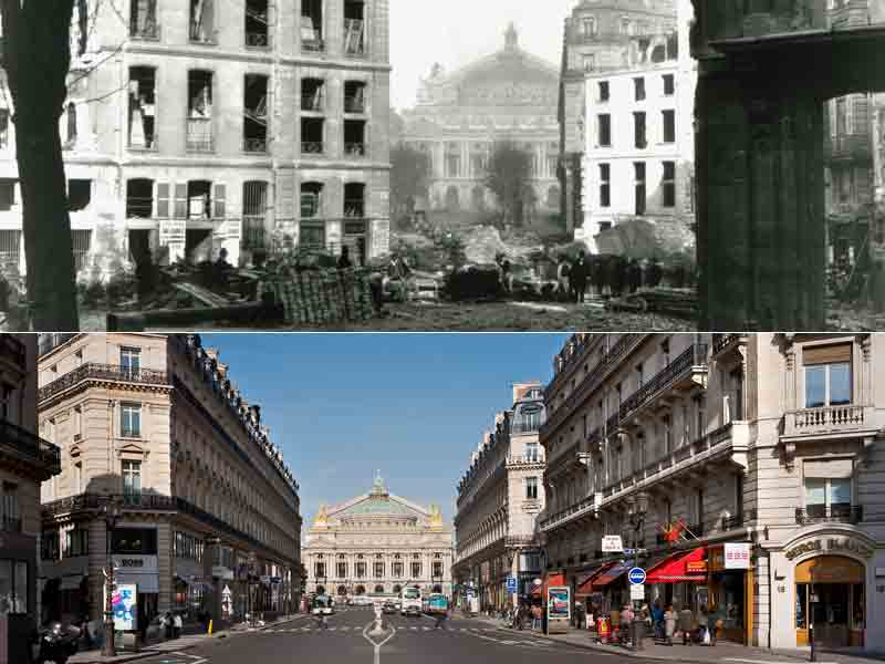
Haussmann’s Paris
In the 1850s, Emperor Napoleon III hired Georges-Eugène Haussmann to build grand boulevards through Paris’ most densely populated neighborhoods. In an effort to eradicate squalor and improve the health and appearance of Paris, Haussmann widened many of Paris’ streets and created a uniform design for the exterior of buildings. Today we think of these large, grand streets and the unique architecture of the center of Paris as emblematic of the city, but Haussmann also argued that his strategies prevented civil unrest and armed uprisings in Paris’ dark, crowded center-city. The wide streets would enable the military to easily navigate through the city, preventing Paris’ tightly built quarters from easily erecting barricades and serving as fortifications in uprisings. There may have been a military argument to these design changes, but the main effects of Paris’ widened streets decreased population density, increased rents, and forced low-income residents to relocate to outer suburbs.
Moses’ New York
Just as Haussmann shaped contemporary Paris, Robert Moses is credited with shaping New York City’s built environment. One of Moses’ greatest critics, the historian Lewis Mumford, wrote, “In the twentieth century, the influence of Robert Moses on the cities of America was greater than that of any other person.” Moses pushed through the building of almost 500 miles of urban highways, including the Triborough Bridge. He also built parks and playgrounds and developed beaches such as Jones Beach State Park for public use. His vision for an automobile-oriented city influenced cities across the country, ushering in a mode of urban planning focused on automobile use. Similar to Haussmann, Moses’ vision of a city had little sympathy for poorer residents and people of color. He used strategies such as building bridges too low to allow for public transit buses, thus limiting the access of poorer residents to places such as the newly developed public beaches. Often poorer residents were forced to relocate for the building of urban highways.
For an extensive history of Robert Moses’s impact on New York, and politics in general, read Robert Caro’s biography The Power Broker [25], which is available through the Penn State Libraries.
Environmental Impact
Systemic racism and classism also have implications for biodiversity and the ecological health of cities. Read this passage from the University of Washington [26] discussing a review paper written by scientists from three universities:
“For example, several studies the authors included found fewer trees in low-income and racially minoritized neighborhoods in major cities across the U.S. Less tree cover means hotter temperatures and fewer plant and animal species. Additionally, these areas tend to be closer to industrial waste or dumping sites than wealthier, predominantly white areas — a reality that was put in place intentionally through policies like redlining, the authors explain.
Fewer trees, over decades, has led to pockets of neighborhoods that are hotter, more polluted, and have more disease-carrying pests such as rodents and mosquitoes that can survive in harsh environments. These ecological differences inevitably affect human health and well-being, the authors said.”
You can read the full review paper here: https://science.sciencemag.org/content/369/6510/eaay4497 [27]
Additional (Optional) Resources
https://belonging.berkeley.edu/segregationinthebay [28]
https://cityobservatory.org/most_segregated/ [29]
https://dsl.richmond.edu/panorama/redlining/#loc=5/39.1/-94.58 [30]
Environmental Impacts of Urban Form
Environmental Impacts of Urban Form
Cities have many different impacts on the environment. Furthermore, different types of cities will have different environmental impacts. Here we consider some major contributors. As you read about these contributors, think about how they might be interconnected with one another.
Transportation Mode
A transportation mode is a way of getting around, such as walking, driving, bicycling, bus, or subway. Non-motorized transportation – walking, bicycling, etc. – is almost always quite a lot more efficient than motorized transportation. Bicycling is actually more efficient than walking because there is less friction with the ground. Walking can achieve the equivalent of about 350 miles per gallon of gasoline; cycling can achieve the equivalent of about 700 miles per gallon of gasoline. However, the difference between the two is smaller once the energy required to produce and recycle/dispose of the bicycle is factored in. And of course, the energy here comes not from gasoline but from whatever food is being eaten by the person walking. The overall environmental impact, then, depends on what types of foods are being eaten.
The efficiency of a car, bus, or train depends heavily on how many people are in it. A bus at average and maximum passenger loads gets about 40 and 330 miles per gallon per passenger, respectively. Note that this does not factor in the energy consumed by the passengers’ bodies as they sit or stand in the bus. Trains can be even more efficient than buses because their metal wheels and rails have less friction than buses’ rubber tires on pavement. Furthermore, trains can move larger volumes of passengers. A bus or train with one passenger will consume a lot more energy than a car with one person in it. This means that cars are not necessarily the least efficient option.
Consider This: Transit and Traffic: A Collective Action Problem
Have you ever been stuck in traffic? Did you enjoy it? Most people don’t. We would rather get to our destination sooner.
If you live in an area where both cars and transit are options, then you may face a collective action problem. In this scenario, regardless of what everyone else does, you’ll reach your destination faster if you drive. However, if everyone takes transit, then everyone will reach their destinations faster than if everyone drives. This is because transit can move more people along a street per unit of time. It’s like using a big fire hydrant hose to move water instead of a little gardening hose. Transit can do this because, in a bus or train, people can sit or stand right next to each other, whereas in cars there’s a lot more space between each individual person. Furthermore, when streets get crowded, there can be more people taking transit, meaning that the transit system can run vehicles more frequently and people have to wait less time for them.
Given what you know about collective action, how would you solve this problem?
Buildings
Buildings are perhaps the single biggest contributor to the environmental impacts of cities. There are major impacts throughout the lifecycle of a building. When buildings are constructed, they tend to require a lot of natural resources for the building materials and energy for the construction process. Then, once they’ve been built, they use a lot of energy for heating, air conditioning, lighting, and appliances. Finally, when the building is no longer desired, something must be done with the building materials.
One way to reduce the environmental impact of buildings is to use less building per person. When people live in smaller residences and work in smaller offices, their buildings will have lower environmental impacts. Apartment buildings can save a lot of energy in heating and air conditioning because apartments share walls with each other and thus don’t lose as much heat to the outside. Smaller residences also discourage people from buying lots of stuff because there is less space to put the stuff. This avoids the environmental impacts of manufacturing the stuff.
Green Buildings
The U.S. Green Building Council [31] (USGBC) has implemented the LEED® [32] program since 1998 to encourage sustainable building design, construction, operation, and maintenance. LEED stands for Leadership in Energy and Environmental Design and serves as a "yardstick" to measure the sustainability of structures by the design and construction industry. A LEED-certified building is often referred to as a green or sustainable building. If a building meets sustainability criteria, it receives LEED certification on one of four levels (LEED Certified, Silver, Gold or Platinum, from the lowest to the highest level). The rating is based on the points a building can earn for sustainable building site selection, maximized water use efficiency, minimized energy use and effect on the atmosphere, and advancements in indoor environmental quality (e.g., material, mechanical, and lighting performance).
Consider This: LEED buildings at Penn State
For example, Penn State's (UP campus) Stuckeman Family Building, home of the School of Architecture and Landscape Architecture, is a LEED Gold complex thanks to its sustainable features such as an exterior construction of recycled copper and durable brick, rainwater harvesting and recycling for landscape irrigation, intelligent lighting control system, and energy-efficient motorized windows that take advantage of natural ventilation (Probing Question: What is a LEED building? [33]).
Air Quality
Cars, buses, power plants, factories, and fireplaces all put pollution into the air, affecting the health of everyone who breathes the air in. All else equal, cities with more of these activities will have more air pollution. But all is not always equal. Some urban areas have more air pollution even when they have the same amount of polluting activities. Here, the environment can be a big factor.
One way that a city can have worse air quality is if it is in an area with a temperature inversion. Usually, air along the surface is warmer because it receives warmth from the ground. Colder air is more dense, which is why we use hot air balloons to go up into the sky. When warmer air is along the surface, that air rises and mixes with the colder air above. This pulls pollution from the ground into the air above where it won’t be breathed in by people, thereby cleaning the surface air that we breathe. A temperature inversion is a scenario in which colder air sits along the surface and warmer air lies above. When colder air is along the surface, it doesn’t rise up into the sky and mix with the air above. Thus cities with temperature inversions tend to have worse air quality.
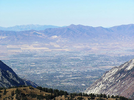
Temperature inversions are usually found in cities with a source of colder air and mountains that trap the cold air in. One example is Los Angeles, which receives cool air in from the ocean. Another is Salt Lake City, whose surrounding mountains also make for famous ski resorts. Here is a photograph from the ski slopes of the Alta resort. Mountains in the background can be seen poking up above low-lying clouds and smog, the result of a temperature inversion.

Here’s a view from a different site, showing the city in the valley below:
Sustainable Urban Development and Urban Farming
Sustainable Urban Development and Urban Farming
Here, we’ll look at some examples of how sustainable urban development has been achieved.
Urban Transit
Copenhagen Calms Its Traffic
Recall the "Cycling as a social norm in Copenhagen" video in Module 4. We have seen that getting people to choose transit can be a collective action problem, and the choice of transport mode can be supported or constrained by urban design. Here's another video (7:22 minutes) showing the efforts that have been made in Copenhagen to ensure that cars do not interfere with people. This approach known as traffic calming has been highly popular in Copenhagen despite it being located in cold, snowy Denmark.
JAN GEHL: In Copenhagen, we had a great influx of cars starting in the middle of the '50s. We called it "The Car Invasion." And by the early '60s, it started to be really bad.
And in 1962, it was decided to take the cars out of the main street of Copenhagen. It's a one-kilometer-long street. There was great debate and discussion, it will never work.
All these businesses of will go broke, and the weather is not good enough for being outdoors in Denmark. But it was closed anyway. That was the start of a long trek where, in small installments, improvements have been made to the pedestrian landscape to the public spaces.
IDA AUKEN: We actually have 18 squares now that used to be parking lots. And when they started shutting them down, and when they made the main pedestrian street here, people were saying, no, this is not Italy. People do not use the public space.
What are you thinking? They don't go walking like, just to take a stroll. And look what happened.
[POP MUSIC]
GIL PENALOSA: I think one of the wonderful things of pedestrian places is that they always surprise you. You don't know what's going to happen. Can we even imagine, for a second, what these pedestrian streets would be like if there were cars on it?
For example, these kids here with the hats, that's the symbol of graduation. They just finished their high school. They are graduating today.
They are going crazy. They are going into the fountains. And we see people also sitting on the floor. I mean, it's so nice and so well taken care of, that people can sit on the floors.
IDA AUKEN: People want to be with people. And that means we go where people are, where there are space for walking, for expressing yourself. For instance, yesterday I went down by the water. And in front of the Royal Theatre, there's this boardwalk. And there was outdoor tango all night.
NICOLE JENSEN: I mean, they're meeting each other. They're having a coffee. They're just chatting.
They're riding their bikes. They're walking. They're walking their dogs.
They're hanging out with their kids. Like, it's just amazing. They're just living. It's the perfect example of public space and how to do it right.
JAN GEHL: So we've seen this gradual transition of the city of Copenhagen, from a traffic-infested city to really, a people-oriented city, which is quite lovely.
[MUSIC PLAYING]
NIELS TORSLOV: The philosophy of this is that if you can keep speed down, say, 30 k or 40 k, you will not have so many accidents. And if you have accidents, they will not be very severe. So that's the basic idea, that if we want to transfer our urban environment into something for human beings, you have to reduce the speed as one of the first things. I have very few examples with the 15 k, actually.
JAN GEHL: We have a number of streets, which we call pedestrian priority streets, where pedestrians have the right of way. But you can have bicycles. You can have cars.
GIL PENALOSA: One of the reasons why it's such a wonderful, walkable place, Copenhagen, is because they have lowered the speed in all of the neighborhoods. I think that in North America, we need to create fantastic pedestrian facilities and cycling facilities along the interiors. But in the neighborhoods, we have to lower the speed below 20 miles an hour. And not only just by putting up signs, but putting up physical barriers.
NIELS TORSLOV: One of the best ways of keeping speed down is actually to use our humps. Because by the humps, you are very, very sure that the speed stays down. Because if you don't have this, you will have guys-- usually guys-- going much too fast in a low-speed area because they can.
[MUSIC PLAYING]
We are standing in front of the old meat market in Copenhagen. And some years ago, there was a lot of heavy traffic coming in, in the morning, especially. So when they closed down the meat market we were thinking, well, got to better change this street. And this is a very central part of Copenhagen. So there's a lot of people living here, and a lot of enthusiasm about also using space for everything else than traffic.
GIL PENALOSA: This is a wonderful street. And can you imagine the difference of quality of life for all of these thousands of condos? And in the middle, they'd built this fantastic park.
NIELS TORSLOV: What's left is actually only a very narrow-- we called it shared-space solutions, where cars, at a very slow speed, and also bicycles and pedestrians can move around each other without really any kind of regulation, as long as the speed is low.
GIL PENALOSA: There are some places where they've got nice benches and restaurants on the side. You go to the next block, and there is a small basketball court. And you go to the next corner, a skateboard park. And then in some of the sides, you have fruits and vegetables that are being sold on the street. And then in another block, you have flowers.
MIKAEL COLVILLE-ANDERSEN: In the Meatpacking District here, we have a lot of new bars opening up. And all the bikes that we're standing around here, it sort of looks like this outside every bar. It's an amazing social network. You ride past cafes and you see bikes parked next to the cafe. It makes the whole city accessible and very, very human.
NIELS TORSLOV: You know, these environments are very attractive for urban living. And it really attracts people to be on the street. And it also raises the price for all those apartments up here. Because this is attraction. I mean, this is urban, trendy lifestyle that we are offering here, by redesigning our street for human beings.
[MUSIC PLAYING]
JAN GEHL: We have 7,500 outdoor cafe seats, which are out for 10 months a year. As all over Europe, in a capitalistic society, if things are not good for business, they will be changed. And what we see in Denmark and all the other European countries, and we even now also see it in New York, in the Broadway area, that when these people-friendly schemes go in, the businesses actually thrive.
GIL PENALOSA: From 6:30, seven o'clock in the morning till midnight, you see people constantly, people coming by. And it's also great for the business. When they were going to create these pedestrian places, initially the retail were very much opposed to it. But afterwards, they found that the best commercial places in the city are their pedestrian streets.
MIKAEL COLVILLE-ANDERSEN: It's anthropology. It's part of the social fabric of the city, that there are pedestrians and cyclists all around you at all time. It's human. This adds an amazing level of social community to a city. And I really think that this is one of the main reasons that Copenhagen is, time after time, selected as one of the world's most livable cities.
IDA AUKEN: I can't even imagine what would happen if somebody said hey, let's turn this square into a parking lot. That would be drama in Copenhagen. So as soon as you win it back, the public space, win it back for human beings and pedestrians, then it's ours and you can't take it away again.
By now, Copenhagen’s traffic calming program has been so successful for so long that people often take it for granted that Copenhagen just is this way. Walking and, in particular, cycling have become very deeply embedded in Copenhagen’s culture. This can be seen in the popular blog Cycle Chic [40], which looks at the fashions of Copenhagen cyclists. The idea of bicycle chic has spread to other parts of the world, including the United States. All this helps establish walking and cycling as a social norm in Copenhagen, such that people there would find it unusual to drive places.
Curitiba Blossoms With Buses
You may have never heard of it before, but Curitiba, Brazil has the best bus system in the world. The city today has about 2 million people, about the same size as Phoenix, Arizona. Indeed, Curitiba and Phoenix have had about the same population for the last 200 years. But while Phoenix was designed predominantly for the automobile, Curitiba was designed for the bus. Curitiba chose the bus because it could not easily afford to build a subway system. By designing the city around the bus, it found it could get subway-quality performance for a fraction of the cost.
At the heart of Curitiba’s bus system is a series of bus rapid transit routes on dedicated streets going into the city center. These bus lines have stations where passengers pay before getting on the bus, expediting the process considerably. During peak hours, buses run about one minute apart from each other, so riders don’t have to wait a long time. Curitiba zoned the bus lines for high-density development to increase the number of people who could easily ride these buses, thereby making them more effective. Check out the 8:03 minute video below for further details about Curitiba's public transit system.
Curitiba’s BRT. The system that inspired Bus Rapid Transit Around the World.
ENRIQUE PENALOSA (Former Mayer of Bogota): We learned a lot from Curitiba. We copied the bus system from Curitiba.
ISMAEL BAGATIN FRANCA (Engineer, URBS): Our goal is to prioritize the flow of people. The city is not made up of machines, it is made of people, so we have to give people the priority.
JAIME LERNER (Former Mayor of Curitiba): When we started, the whole idea that every city which is close to one million people should have a subway. And at that time, Curitiba had 700,000 people. The subway should have speed, reliability, comfort, and good frequency. We started to imagine, could we have on surface all these conditions?
PRESENTER: Today in the city of Curitiba we have 1.750 million inhabitants. And including the greater metropolitan area of Curitiba we have 3.250 million people.
CLEVER UBIRATAN TEIXEIRA DE ALMEIDA: We have different kinds of services within our transport system, including the BRT, which is, our line with the greatest capacity.
JAIME LERNER: We started with one line, with 25,000 passengers a day. But this system is being improved and now is transporting two million, 300,000 passengers a day, which is the same number of the subway of San Paulo.
KENNTH KRUCKEMEYER: 75% of the people in Curitiba get to work on a bus every morning. A city like Phoenix has exactly the same population as Curitiba over the past 250 years. And yet, in Phoenix, 1% of the people go to work on a bus.
CLEVER UBIRATAN TEIXEIRA DE ALMEIDA: We have a system on a dedicated lane with a higher average speed with the same-level boarding which moves passengers in and out the vehicles faster. Advanced fare collection also contributes for a faster boarding.
ISMAEL BAGATIN FRANCA: Today we have 5 axis, corridors, where we have exclusive lanes.
JAIME LERNER: A normal bus in a normal street transports X passenger per day. If you have a double-articulated bus, a double accordion in a dedicated lane, paying before entering the bus and boarding at the same level, you can have four times more passengers per day in the same space. OK, one bus, 300 passengers, every 30 seconds is 36,000 passengers, per hour, one direction, which is the number of a subway.
CLEVER UBIRATAN TEIXEIRA DE ALMEIDA: The integrated system has various types of lines, such as the “alimentadoras” that operate in residential neighborhoods far from downtown, bringing people to the bus terminals, where they can exchange buses without paying another fare and use the express lines. With the direct lines that also use the tube stations, and have less stops. We have the “interbairros”, which cover a perimeter. We have 6 “interbairros” that connect all transportation axis.
PRESENTER: I’m waiting for the South Circular bus. It’s good because it covers the whole region.
PRESENTER: We do the route six times which takes exactly six hours. I don’t have any complaints. This is one of the best we have. It’s possible to cross the city from here. The traffic is not as bad as people say.
LUIS PATRICIO: Unfortunately, during the last decade, the average speed of the buses has been declining. This is not exactly the problem of the public transportation system, but because of the increasing number of cars in the city.
Dr. FABIO DUARTE: Every time, when people say, for instance, well, the subway system would be better for the city, because then we could put the bus out of the city, the traffic would be better, because all the mass transportation would be under the ground. It's a better way of seeing the problem, because the problem is not the people who use the buses, but the people who use cars. So I think to incentivize the BRT system and put more buses on the streets, it's good for us.
CLEVER UBIRATAN TEIXEIRA DE ALMEIDA: Since its creation, we have been improving these corridors. We have a project to allow bypassing in the dedicated bus lane, that intends to extend the capacity of the bi-articulated buses in the dedicated lanes.
ISMAEL BAGATIN FRANCA: The Boquerião axis will have smart traffic lights, that will identify the bus and let it pass.
PRESENTER: The system could be way more efficient if it had integration and had been planned for the bicycles.
CLEVER UBIRATAN TEIXEIRA DE ALMEIDA: Cyclists use of dedicated bus lanes is dangerous. It may seem comfortable for the cyclist at first, because it’s a wide lane and there’s not a lot of vehicles using this lane, but it’s dangerous for the cyclists and for the users of public transportation as this lane is used by large vehicles, the bi-articulated, which carry up to 270 people.
CAROLINE SAMPONARO: So the major lesson that New York City should take from Curitiba with regard to bicycle planning is that when bus rapid transit is brought into a city, bicycles need to be factored into the designs. So all of the old bus rapid transit lines in the city don't incorporate bicycles at all. But the city in Curitiba is now realizing that bicycles want to ride on the streets that have been redesigned and made so much calmer.
Dr. FABIO DUARTE: The new line, the green line, we have the two bus lanes, the bypass lanes, and we have the bike lane.
PRESENTER: I live right here in Curitiba. I’m working in the Green Line.
PRESENTER: The green line was a federal highway. It was transferred to the city, and we were able to make it a transportation axis.
CLEVER UBIRATAN TEIXEIRA DE ALMEIDA: We are building a linear park. The bike path will follow the sidewalk. All 18km of the Green Line will have a bike path.
ISMAEL BAGATIN FRANCA: You need to take care of land use and transportation together, to induce city growth.
Dr. FABIO DUARTE: We can go from the bus stop to the stores, or the house, et cetera, almost each 100 meters, we have a kind of crossing street. This gives to the city a permeability, so people can walk around and used the stores, et cetera.
CLEVER UBIRATAN TEIXEIRA DE ALMEIDA: It’s not just a transportation corridor. There is a whole urban planning setting that is also important. Sometimes people think that simply building a dedicated bus lane will solve the transportation problem.
JAIME LERNER: There is no end for creativity. If you want creativity, cut one zero from your budget. If you want sustainability, cut two zeroes. If you want to make it happen, do it fast.
Bogota Gets Its Exercise
In the American imagination, the South American nation of Colombia is commonly associated with the drug trade. But Colombian drug cartels are fading. Meanwhile, Colombia has been very active in sustainable development. In one example of this, its capital city, Bogota, has emerged as the world leader in weekly car-free events known as Ciclovias.
The Bogota Ciclovia happens every Sunday and holiday. Cars are forbidden or significantly restricted on 120 km (75 miles) of streets. In general, the presence of automobiles on our streets is a threat not only to the environment but also to children and anyone else wishing to use the streets. The streets can then be used safely and comfortably for cycling, walking, and skating. The streets also feature dances, aerobics, and other outdoors activities. The Ciclovia is a way for people from all walks of life to get some exercise and fresh air. Today, similar events can be found across the world, but none are as large as Bogota’s. Watch the following 9:41 minute video about the Bogota Civlovia.
PARTICIPANT: [SPEAKING SPANISH]
PARTICIPANT: [SPEAKING SPANISH]
CICLOVIA WORKER: [SPEAKING SPANISH]
KARLA QUINTERO: So it's 2 o'clock today and the Ciclovia is almost over. We've had a really long day. We got up at 5:00 in the morning and we got to see how it all started, everything from packing up the vendor stations in the trucks to barricading the streets and closing it to cars. It was pretty light traffic at the beginning because the weather wasn't so great, but at about 8 o'clock it started getting packed. It's a really beautiful way to see the city. There's just tons of people, all different kinds, all different ages. There's even a segment called the Recreovia, and this is absolutely great because they have about 20 stages with aerobics instructors and rhumba instructors, and they're giving free classes to any citizen that wants to participate. It's really something beautiful to see.
CICLOVIA WORKER: [SPEAKING SPANISH]
GUILLERMO PENALOSA: When we were starting the Ciclovia, when I was commissioner of parks, sports, and recreation, we were going to increase from 13k, which is about 8 miles, to over 90k. And we needed a lot of people to work on it. So we put an ad in the paper saying we need supervisors of the Ciclovia and these are the requirements. We got 20 resumes and we were expecting over 200.
So at the time the number one program on Colombian's TV was Baywatch, so we put an ad in the paper saying we need Bikewatch. Tall, handsome, athletic, blah, blah, blah, and we got 1500 resumes, which shows that social marketing works. And so now these people are called Bikewatch, and they're like the managers of the Ciclovia.
CICLOVIA WORKER: [SPEAKING SPANISH]
CICLOVIA WORKER: It's the biggest program around the world. And doing sport 120 kilometers in a city is so different, it's strange. And always we are as university students. And it's a good job because we have enough time for that kind of labor.
CICLOVIA WORKER: This is beautiful, man, because we work for the city. Everybody smiles at you. This is very beautiful work.
KARLA QUINTERO: [SPEAKING SPANISH]
CICLOVIA WORKER: [SPEAKING SPANISH]
[MUSIC PLAYING]
CICLOVIA WORKER: [SPEAKING SPANISH]
KARLA QUINTERO: [SPEAKING SPANISH]
PARTICIPANT: [SPEAKING SPANISH]
CICLOVIA WORKER: [SPEAKING SPANISH]
CICLOVIA WORKER: [SPEAKING SPANISH]
CICLOVIA WORKER: [SPEAKING SPANISH]
GUILLERMO PENALOSA: The obesity rate in the US have skyrocketed. Almost every state has obesity. Not overweight. Obesity. And how else can you get thousands and thousands of people doing physical activity? So then the infrastructure is there. It's free. The roads are already there. All you've got to do is close it. You need operational costs to set it up, and then you can get this fantastic idea, which is like a party that everybody attends. The rich and the poor, and the young and the old, and everybody.
PARTICIPANT: [SPEAKING SPANISH]
CICLOVIA WORKER: [SPEAKING SPANISH]
CICLOVIA WORKER: [SPEAKING SPANISH]
CICLOVIA WORKER: [SPEAKING SPANISH]
PARTICIPANT: [SPEAKING SPANISH]
[DANCE MUSIC PLAYING]
KARLA QUINTERO: [SPEAKING SPANISH]
PARTICIPANT: [SPEAKING SPANISH]
CICLOVIA WORKER: [SPEAKING SPANISH]
CICLOVIA WORKER: In the Recreovia we have different activities from 8 o'clock to 1:00 o'clock. The first station that we have is a basic aerobics class. The second class is stretching. The next class is class for children. In the classes for children we practice with the parents and the children, activities with music.
KARLA QUINTERO: How excited do people get?
CICLOVIA WORKER: A lot. They are very happy. That prefer come here instead of being in the house.
CICLOVIA WORKER: [SPEAKING SPANISH]
KARLA QUINTERO: [SPEAKING SPANISH]
CICLOVIA WORKER: I give classes.
KARLA QUINTERO: You give?
CICLOVIA WORKER: I'm the teacher.
KARLA QUINTERO: Of which one?
CICLOVIA WORKER: All the classes. This is the uniform. [LAUGHS]
[MUSIC PLAYING]
CICLOVIA WORKER: [SPEAKING SPANISH]
GUILLERMO PENALOSA: A lot of cities are thinking of doing activities like Ciclovia. Guadalajara started only two years ago with eight miles, and now they are at 16 miles. Santiago, Chile started. In Paris, France they close down roads. In Ottawa in Canada there is, like, 35 miles of Ciclovia on Sundays from May to September. So I think that there are some cities in the US that are thinking about it, such as Baltimore, Cleveland, Chicago, Portland, New York. And this is something that any city could do, cities of 50,000 people or cities of 10 million people.
Urban Farming
Urban farming can take a variety of forms but, conceptually speaking, it refers to crop and livestock production within cities and surroundings. Urban farming (also known as urban agriculture) takes advantage of every inch of private or public space and can involve anything from rooftop farming to balcony gardening, from farming in parking lots to farming along roadsides. Urban farming plays a large part in contributing to sustainable urban development. As more and more people are living in cities, urban agriculture is emerging as an attractive means of supplying urbanites with food. At the same time, urban farming is an important strategy for reduction of hunger and poverty, improvement in resident health, and climate change mitigation and adaptation.
Detroit (and the state of Michigan generally) makes a good case study for urban agriculture. Watch minutes 16:29-22:05 of the PBS video below to see how urban farming helps communities in food deserts (places with no grocery stores offering fresh produce) access more affordable and healthier food and allows people to make a living by selling their food in local markets.
Narrator: Modern food production promised to feed the world on the cheap. But are the costs proving to be more than we can bear? Fruits and vegetables are trucked around the country and around the world, and most people have no idea who grew them or how they got here. Isn't there a better way? From the rooftops of New York City to the vacant lots of Detroit, there's a growing movement to change the way we eat. Join us as Food Forward explores the explosion of urban agriculture across America. And meet the food rebels who are growing food right where we live.
[rock guitar music]
Dr. Dickson Despommier, Author, “The Vertical Farm”, Columbia University, NY: Here we are in New York City. Five boroughs, 8 million people, most densely populated area in the world. There are 28,000 restaurants in New York City. If New York City were to decide tomorrow to stop importing food, we'd have a big problem right now. Most of us live in cities now and over 50% and maybe 80% in 20 years from now. We love each other. We like to be with each other. We like to sit down to a good meal together. And we all want to know what's in our food, so why not grow it where we live?
John Mooney, Chef, Bell Book & Candle, New York City, NY: My name is John Mooney. I've basically been in the restaurant business my whole life. I've never made money doing anything other than being part of a restaurant crew from start to finish. Since about 12,13 years old. I have done some conventional farming projects to supply restaurants that I've done in the past. It's very difficult to manage, very difficult to maintain. So, I looked into alternative forms of farming. In an urban setting, I felt with the dead space of the rooftop, the technology was smart. It just makes sense. We're in the West Village of Manhattan. We're standing here in the middle of my hydroponic rooftop farm. In the beginning, there was a lot of curiosity as to what was going on up here, because it looks kind of space aged from a distance. And I'd explained it by phone or in person. And now I'm at the point where I tell everyone, you have to see it. The seed sits inside this net where the roots grow inside the tower. This big cylinder has a pump that trickles water down the sides and that feeds the roots and that recycles the nutrients through the bottom is a big base filled with around four gallons of the nutrients, which is fed naturally by gravity.
What I do is I pull the cup out of the tower. So, you see how nice and lightly colored the roots are. And look how long they get, right? I mean, that's strong. Let's look at this arugula right here, okay. We just pulled that a few hours ago. I broke it down. Roots attached. You see what I'm doing. And I believe it totally makes a difference. The flavor is absolutely amazing. When you enter the garden from the stairwell and you open that door. It's kind of like a sanctuary of sorts.
Andrew Coté, Urband Beekeeper, New York City, NY: It's down here. But I have… am I going to get lucky? It's going to be a hydrant. One of the biggest problems with urban beekeeping is parking a truck. It really is. Some honey for you ladies? Okay. You're doing the right thing. You're welcome. Some honey for you, soldier? Miel batido. Whipped honey. No, you're sweet enough? Honey for you, miss. That's the plain whipped. We also have whipped with cinnamon.
Shopper: The local honey is really good for allergies.
Andrew Coté: Local honey is very good for allergies. Where do you live?
Shopper: In East Village.
Andrew Coté: In the East Village. This honey is from 14th and Second.
Shopper: Okay.
Andrew Coté: So, it's very close to where you live. I think this is from Brooklyn. The Manhattan honey has higher rent and the Brooklyn honey has more attitude.
Inside the hive, there's the queen bee, the worker bees who are females, and the drones who are males. Once the queen has been mated, she makes babies. She lays up to 2000 eggs a day. One beehive will produce something around 80 to 120 pounds of honey per year. And I know they help pollinate the community gardens, the window sills, the rooftop farms that saturate the city. This is my office, the rooftops of what is to me the greatest city in the world.
Karen Washington, Urban Farmer, Garden of Happiness: It's showtime! Hello. Good morning. How are you? Ola. como estas? It's all in a presentation. We're in the Tremont section of the Bronx. It's an area that has, as you can look around, a lot of fast food restaurants, not a lot of access to fresh food. And so, as urban growers and community gardeners, since we grow it, we know it. We decided to bring fresh produce to this neighborhood. My garden is Garden of Happiness. It started 23 years ago. It was a vacant lot. Most of the boroughs in New York City in the late seventy’s and eighty’s had so many vacant lots. So, with two things to do, either to let the dirt and garbage accumulate, or take that vacant lot back and start growing food. The biggest joy I have is when a customer comes and they'll say, where are those collard greens? And I say, I got them for you. No matter what, I will grow collard greens. Hopefully we can instill that into young people to really know where their food comes from. Not that everyone could be a farmer, even though I would love that. I would love that. But at least everyone can be an educated consumer.
Ben Flanner, Head Farmer, Brooklyn Grange: It made sense to try to do something in the city for a number of different reasons. Growing food as close as possible to the consumers that eat it. Utilizing all this open space that we have, all these roofs that just kind of have the sun beating down on them all day. The soil is about 25% lighter than a typical topsoil would be if you just stuck a shovel in the ground. So, that makes it more suitable to roofs,
obviously, just because it is lighter. The stones kind of rise to the top and they're all porous. They all have holes in them. And if you feel it, you can just tell it's light.
I'm going to pick that kakutza too. Look at that. It's awesome, isn't it? People like the fact that it's locally grown, and they almost expect it sometimes. For a market like this, it should be the case. This market's been great for the neighborhood. People are pretty excited about it and thanking us for being here.
Gwen Schentz, Farm Manager, Roberta’s: This is Roberta's. It's a restaurant located in Bushwick, Brooklyn. It's almost three years old now, and we make pizza. Right now, we're making a pizza with tomatoes from Brooklyn Grange. They're really nice heirloom tomatoes pizza kitchen will slice up, and sometimes they'll actually make a sauce out of them. It's really nice for me because I work both at the Grange and here at Roberta's. So, I'll be coming back from the farm, and I'll load up my truck with tomatoes and bring them here. And these guys will make pizza and everything kind of comes together. I always thought that to be a farmer, I'd probably have to leave New York and move outside the city. But it turns out that I can get the best of both worlds right here.
Dr. Dickson Despommier: Where does our food come from? If we could produce it inside the study, you could save on transportation and spoilage and packaging and unpackaging, and you could market it right at the bottom of the building. So, you could have a farm with lots of layers in it, maybe 10 or 15 stories tall, fully integrated with hydroponics and aeroponics. You could even have aquaponics in the basements raising tilapia or striped bass or mollusks. And we know how to do all that already. Frustrating part of it is, why don't we do it?
Will Allen, CEO & Farmer, Growing Power: I bought the last remaining registered farm in the city of Milwaukee in 1993, and I made a pledge to the city that I would hire young people from the community to work at the farm. It struck a chord with a lot of folks in Milwaukee, and I started getting calls and requests for me to work with the different nonprofits and schools. We started adding, like, the aquaponics, the worm system, started putting up hoop houses, the animals, all these different pieces. We have a very innovative renewable energy system that heats the water so we can grow tilapia. And also, that heated water helps keep our greenhouses warm during the winter. Food is the most powerful thing in our lives. It's the most powerful thing in community development. People are just realizing that if they want to be healthy, they're going to have to take control of their food in their communities. We need to really scale this thing up.
Hendry Hebert, Facility Manager, Sweet Water Organics:Aquaponics is the conjoined systems from fish production and plant production, bringing them together in a symbiotic relationship. These three systems here, E, F and G are designed for lettuce right now. We started with an upscale model of Will Allen's. Changed a few things on it, tried to make it a little more efficient and a little faster. We have a place for the fish to live, a place for the plants to live, a place for the bacteria to live, and a pump to push the water all through it. The pump provides all the propulsion, just like in the river or the stream. And we've just captured that into a little bitty box. And there's a variety of sizes in here.
Theresa Kopak, Chief Executive Director, Sweet Water Organics: What I love the most about my job is knowing every day when I go in there, I'm working on something that will directly impact the well-being of others. No matter how tired any of us are, we get up in the morning and we want to make this happen and be available to people worldwide. That this is something that can be replicated in any city, in any abandoned factory building warehouse.
Theresa Kopak: Hello. Hi, Peter. I have fish for you.
Peter Sandroni, Owner & chef, La Merenda: Excellent. Cool. That's great. I love the fact you guys are just down the street. I think that a lot of people have a misconception of what tilapia is like. We take Swiss chard, fingerling potatoes and shallots, all grown locally, sauté it all together. And we sauté the tilapia that we have seasoned and dusted in flour. We brown some butter in another sauté pan, and we just bring it all together at the end, put the fish on top of the vegetables, and then top the fish with the brown butter and minus the salt, pepper and flour. Everything is local. We call it the All-Wisconsin Dish, and it's a really, really simple dish, and everyone seems to like it a lot. We figure with 34 systems in this building, at that 7500 fish every five to seven day mark, it will employ like, 40 people. Here we'll provide food for the three to five mile radius around us. It can be done anywhere.
Will Allen:I believe we're creating a new industry that could create thousands of jobs. The thing that we do best is inspire people to want to go out and get something started, to do something. To really inspire them.
Abeni Ramsey, Farm Manager, Dig Deep Farms: My name is Aveni Ramsey, and I'm an urban farmer. Through my experience as a mother living in West Oakland, there was a time when I was having a hard time feeding my kids and we were eating Top Ramen. And because of my upbringing, I knew that that wasn't right. But that's what I could afford because I could buy it in a pack like this for like, $5, and they sold it at the corner store. So, I was riding my bicycle through West Oakland and I saw a sign posted by City Slicker Farms for fresh produce. And there was the farm stand. It was beautiful produce. And so, I started going there, and then I found out that they will build planter boxes in your backyard. So, I applied, and I had them come, and they built the planter boxes. I grew everything we needed in the backyard. I didn't have to buy any produce. Then I got a flock of chickens and we then had our protein source, eggs. My transition has been unbelievable. I am the farm manager of Dig Deep Farms and the owner of City Girl Farms. We are right now harvesting for our CSA, or Community Supported Agriculture Produce Box, which is delivered to our subscribers on a weekly basis.
You guys need clippers. The whole idea of urban agriculture. What gets me is that people act like it's some new and revolutionary idea, but people have been farming in the city since the time there were cities. We've partnered with Flora Restaurant and this great chef, Rico Rivera, who will be purchasing produce from us directly.
Rico Rivera, Chef, Flora Restaurant: Yeah, this guy's incredible. Today from Albany, we received some nettles. Wild nettles. I'm thinking off the top of my head, the nettles. We're going to throw them in one of our chickpea ragus. In the pan, we saute some onions, throw in the chickpeas, some roasted delicata squash, some roasted onions. Then we saute up with a little bit of brown sugar. The nettles complement that real nicely with their earthiness. Toss toss on the plate. Real juicy with a grilled flatbread on the top. It's amazing. You can't get closer to source than what we're doing here. I mean, again, they're probably 6 miles away. We order, she picks it's here in the morning.
Abeni Ramsey: Hi, it’s Dig Deep!
Dig Deep Customer: With my fresh vegetable! I appreciate this so much!
Abeni Ramsey: Of course. All right.
It's a modern idea that you get your food from a store and that's the only way that you get your food. Because you're completely dependent on the grocery store to provide for you what you need. You can live in a community where they don't put grocery stores, where there are no jobs, and where there is limited transportation. And it's like living in the Third World.
[music]
Song Lyrics: In the city. Your dreams flying tigers and wings violence seem to be the only thing depicted on the screen, but it's more to the Motor City. Coming strolling with me got a sidestep to ignorance and stepping the black businesses.
Malik Yakini, D-Town Farms, Detroit, MI: Really, for the last 50 years, Detroit has experienced a decline in population. And so, with the decline in population came a decline in the city's tax base. So, that's impacted the ability of the city to maintain the same infrastructure that it maintained prior to 1950. In 1950, the population of the city was about 2 million, and now it's somewhere about 750,000 or so. There's many neighborhoods in the city of Detroit now where there's no place within walking distance to get fresh produce. And unfortunately, many Detroit residents are eating out of gas stations or out of convenience stores. That, of course, is causing a health cris.
Cornelius Williams, 4-H Farm Advisor, Detroit, MI: And people wonder why they're sick. Number so-and-so yellow, number so-and-so blue is not food. Check the children's cereal and read the label on what's in there, folks! It's killing you! But it does it slowly.
Travis Roberts, Chicken Farmer, Corktown, Detroit: There were a lot of homes in this neighborhood when I was younger, when I was coming up. But as I got older, I watched them decrease by the month. Homes were burned down, tore down. People moved away, and the homes became vacant. People stripped them and then people set them on fire.
Edith Floyd, Growing Joy, Detroit, MI: They stopped burning down all the garages, and people stopped moving out. I had a two-car garage with an apartment upstairs to burn that down too. It felt real bad at first, and then I said, okay, I might as well make it better by adopting a lot and putting a garden on it.
Malik Yakini:Many people have begun looking at urban agriculture as a way to supplement their food sources and to kind of fill the voids that's been created by the departure of supermarkets that were once in Detroit.
Greg Willerer, Brother Nature Produce, Corktown, Detroit: I guess my stomach led me to all this. A lot of us here in Detroit have a hard time finding good local food, healthy food, and somewhat inexpensive food. There's a really strong demand for local and chemical free produce.
Travis Roberts:The idea of having chickens in the city came to me. I was talking to the head chef at Slow's Barbecue, and he was telling me that he would buy eggs from me every week. Then I asked, how many dozen does the restaurant go through? He's like, two cases a week. That's 60 dozen per week that we would buy from you. And so, I figured we would need about 124 chickens, give or take one or two, because some of them don't lay every day. Some chickens won't take to egg laying immediately.
Cornelius Williams: I want you to get a good shot of this okra right here. And you take and harvest it, and you can't beat real okra, and it is delicious. The city is the only place that farmland is increasing. Every time they tear down a house or tear down this, that's potential farmland.
Edith Floyd: I grow all types of greens, tomatoes, okra, corn, beans, eggplants, watermelon, cantaloupe, cucumbers, squash, onion, leech, and lot more stuff.
Malik Yakini: We have soaring rates of obesity, both for children and adults. We have soaring rates of hypertension, of high blood pressure, heart disease. But all of those things are to some extent controllable by diet.
Travis Roberts: I was always a heavyset guy until maybe about a year ago when I slimmed up and lost about 125 pounds.
Cornelius Williams: You get exercise, you get good, fresh food. I think living on the farm and eating a better grade of food makes a difference in life. I come out in the garden and work the garden, and as I'm working, I eat some of everything that I, you know, that's in the garden, this is what your body needs fresh. You don't need a salad that's been cut up and been in a bag and went halfway across the country.
Travis Roberts: Everybody's been pretty excited about it. People wanting to come by and see the chickens and people wanting to donate, and people asking, is there any list that I can get on to where I'll be first in line? Is there any line for deliveries? And stuff like that. So, local restaurants have supported even local catering companies have supported us, so we're getting nothing but love.
Edith Floyd: I put it for 14 lot, and they didn't let me have 14 lots. And that's only a quarter of the block.
Andrew Coté: I want the whole block. In spite of the fact that Detroit just has all the ODS stacked against it, Detroiters have this rare opportunity to actually rebuild their city, and we're doing it.
Edith Floyd: I'm willing to do my part. I would take one block at a time, and if nobody want it, I would take the next block. If it's vacant, I'll take it.
[music]
Song Lyrics: From abandoned lots to garden flies the city on the rise from working in the plant back to controlling our lives nine to five only pay the rent dictating how the day is spent and dinner at the drive through just ain't making sense. Got me convinced the only way to make amends is to plant seeds. Where the weeds grow behind the fence. It's a movement in the streets, now. Ask Malik from Detown. We farming out at Rules Park. The whole city can eat now.
Travis Roberts: My vision for Detroit is seeing people working together. Whether we like it or not, living in Detroit, we are a family and we have to support each other.
[music]
Dr. Dickson Despommier: Everywhere you go in the world now, people are trying to figure out how can they bring their food supply closer to where they live?
Will Allen: I'm not saying that industrial agriculture is going to go away, because it's not.
Malik Yakini: We're not suggesting that gardens can replace supermarkets, but we think that this can be an alternative.
Abeni Ramsey: Look at what the needs are right in your community. Look at what the needs are in your household. I think it's a revolutionary act to plant a tomato plant in your backyard.
John Mooney: Rooftop gardening, to me, is off the hook. It's evolutionary. This is the future. You're looking at it.
Travis Roberts: I'm hoping that people say, look at Trav. He grew up from the same neighborhood that I did. He went through the same stuff that I did, trouble and whatnot. Maybe I can do that's.
Hendry Hebert: If I could be any vegetable, I would probably like to be a tomato.
Ben Flanner: I would probably be an eggplant. I think they're a cool vegetable. They're like super unique.
Dr. Dickson Despommier: Garlic. Definitely garlic. I'm a garlic person. I'm a flavor molecule that wants to get into everybody's cuisine and spice it up.
John Mooney: Right now, I'd be Arugula because I'm Spicy. I'm all hot and bothered. I'm all mixed up with some other sexy ingredients.
Abeni Ramsey: I'd be a Brussels sprout. Brussels sprouts are surprising. They come up, and they look like they might be broccoli. And then it changes and you’re not sure. And they're not easy to grow. But then you get these little nuggets of deliciousness. So, I suppose that's me. I'm always changing. It took me a long time to grow up, but I think I'm now a nugget of deliciousness.
Urban farming can take place basically anywhere. Check out the 3:24 minute video below to find out how people are growing food in recycled car tires in Haiti. On one side, urban farming is a response to food and livelihood insecurity. On the other side, urban farming grows a greener future because food grown locally requires less transportation (or fewer food miles) and therefore reduces ecological footprint.
SPEAKER 1: From United Nations Television, this is UN in Action.
SPEAKER 2: [INAUDIBLE] is a district of Carrefour Feuilles in Haiti and is undergoing some major changes. It's becoming greener.
For some months now, recycled car tires have become ever-present fixtures on the roofs and gardens of homes, from which all kinds of vegetables and spices are growing.
They are part of a project called Urban Agriculture. The goal is to fight against food insecurity.
[? Arnesia ?] Boss, a single mother, is one of the beneficiaries.
SPEAKER 3: Sometimes I wake up in the morning, I have bread, and I could make a soup for the children. But I had to buy vegetables. Now, I can just take them from the garden. This helps a lot and improves the living conditions of the children and the whole family.
SPEAKER 2: With support from local partners, Oxfam, a nonprofit organization assisting the UN stabilization mission, MINUSTAH, with several projects, began setting up a nursery here a year ago.
Peleg Charles, media and communication officer from Oxfam.
SPEAKER 4: We see success in other countries that used urban agriculture to combat food insecurity. On one hand, we help to improve food security in the households. And on the other hand, we help the population to participate in the protection of the environment.
SPEAKER 2: About 100 people, including [? Arnesia, ?] receive seeds, seedlings, agricultural tools, as well as training to grow plants in car tires. Over the past year, Oxfam has purchased nearly 6,000 car tires and over 60,000 seedlings, part of a cooperative effort with several UN agencies to improve food supplies in the country.
Herbs and 10 different kinds of vegetables, such as tomatoes, beets, carrots, and eggplants, are growing in urban gardens. Many are relying on them as an alternative means for enhancing food security and improving livelihood.
SPEAKER 3: From what is growing in my garden, I could also make a living. At the moment, I'm only consuming, but I also want to sell them. Soon I would like to see my garden grow, providing not just food, but also income for the family.
SPEAKER 2: For [? Arnesia, ?] who lives with five children and without a big income, urban agriculture is a blessing. While she will get the seeds and car tires for free from the project for two years, she is already preparing herself for the next step-- creating a garden in her own backyard and learning how to manage it.
This report was produced by Sandra Miller for the United Nations.
Consider This: Urban Agriculture In Cuba
Earlier in this course, we learned that the Green Revolution was, in part, an effort by capitalist countries in the Cold War to get Third World countries to side with them. The Soviet Union was also active in providing agriculture aid to Third World countries such as Cuba.
The world’s largest urban agriculture program comes from Cuba. When the Soviet Union collapsed in 1991, Cuba lost its source of aid and thus faced food shortages. As a way to cope, Cuba turned to urban agriculture as a way to feed itself. This agriculture is performed almost entirely without artificial fertilizers and pesticides, simply because Cuba lacks access to these inputs. In some ways, this makes Cuba’s national agriculture system more sustainable and less vulnerable to disruptions in the supplies of these inputs. On the other hand, this system involves more labor and lower yields than is often found elsewhere. Still, as with Cuba’s overall development, much can be learned from its agriculture system.
Check out this Youtube video by Kitchen Gardeners International (6:05 minutes).
ROGER DOIRON: Hi, this is Roger Doiron of Kitchen Gardeners International. I recently had a chance to travel to Havana, Cuba to study its urban farms and gardens as part of a research tour organized by the Kellogg Fellows Leadership Alliance. That's me there, trying to look like an international researcher. You might be asking, why go to Havana for such an experience.
Most people associate Cuba with another type of revolution, the Communist Revolution led by Fidel Castro in the late 50's. And when they do think of a Cuban agricultural product they can put in their mouths, they're much more likely to think of a cigar than a carrot. But Cuba offers a unique case study for local foods advocates in that it is not only an island nation in terms of its geography but also its economy and politics as a result of being cut off from the world by two important historical events. The first was the embargo imposed upon Cuba by the United States in the early 60's, and which remains in place to this day, making it difficult for Cubans to obtain many products that we take for granted. The second event was the fall of the Soviet Union in 1991 which absolutely decimated Cuba's economy.
The Soviet Union had been Cuba's largest source of both trade and aid, and when the Berlin Wall fell, Cuba's exports and imports fell with it, plummeting by 80%. The Cuban government euphemistically referred to the years after 1991 as the so-called Special Period, but the hungry period would have been a more accurate term. Essential items, such as food, medicine, and gasoline, were in critically short supply. There was an old joke in Cuba that soon after Castro seized power in 1959 the signs at the Havana Zoo changed from "Please don't feed the animals" to "Please don't eat the animal's food." And when the special period began in '91, the old joke changed again, taking on an even more unappetizing flavor. But for those who lived through the special period, it was anything but a laughing matter.
Cuban's daily caloric intake dropped by nearly one third, leading to an average weight loss of 20 pounds per person. Although history has played its share of cruel jokes on Cuba, there are some who think that a city like Havana might end up having the last laugh. The experience of living through the special period has forced Havanans to become more resilient, self-reliant, and innovative in their food production. Organic farms and community gardens, known as organoponicos, can now be found throughout the city. Nearly all the seasonal fruit and vegetables consumed by Havana's two million residents are being sourced from gardens and farms located within 30 miles of Havana.
Fossil fuel powered farm machinery is being replaced by people power and animal power, which are more appropriate technologies for the small scale of agriculture typically found in and around cities. Synthetic fertilizers are being replaced by organic compost and animal manure. Monocultures and the synthetic pesticides they require are being replaced with better and more diverse agricultural systems and practices. And perhaps most important of all, small-scale organic farmers and gardeners are being seen as critical to Cuba's Homeland Security and are being valued accordingly. For example, growers of healthy organic fruits and vegetables, like this one I met, are paid three times more than doctors in Cuba, offering a fresh foreign perspective on one way of achieving health care reform.
I came away from the trip feeling inspired, but my enthusiasm was also tempered by the knowledge that I'd seen but a part of a larger and more complex story. Despite its advances in urban agriculture, Cuba still remains heavily dependent on imports of rice, wheat, and dairy products, and the antiquated Soviet Era food rationing regime, put in place in the early 60's, continues today. In fact, when you visit Havana and you see its crumbling colonial buildings and vintage cars, you can't help feel a bit like a time traveler. But when it comes to sustainable urban agriculture, however, a trip to Havana may well be a trip to the future.
Like a cab ride down Havana's timeworn cobblestone streets in a '57 Chevy with no shocks, the journey to sustainable food security is going to be a bumpy ride. If we do look to Havana's urban farms and gardens as one vision for the future, the real question becomes, what's the best road to take to get there. The one question we can't afford to debate is whether or not to get started down this road. , With over a billion hungry people in the world and more people on the way, the globe's special period has already begun, and the time to start that journey is now.
From previous pages, we learned that urban design involves collective action if a city is to be developed in some coordinated fashion. Likewise, the urban sustainable development process involves a mix of government regulations, private market forces, and community self-organization.
Transitioning to Sustainability
On this page, we conclude our unit on sustainable development by discussing the process of transitioning from less sustainable to more sustainable development.
In the sustainable development modules, we (the course designers) have attempted to show that sustainable development can also be enjoyable development. To see this, recall the end uses of sustainable development. Foods that have lower environmental impacts are often also healthier and tastier. High-density, mixed-use urban developments often have vibrant culture and aesthetic beauty. Non-motorized transport (walking, biking, etc.) also gets us exercise, making us healthier and happier. We see this time and time again: sustainable development is pleasant development. It would seem to be a win-win situation: people today get to live nice lives, and the environment and future generations benefit in the process. This observation is in stark contrast with the idea that protecting the environment requires arduous sacrifices. Perhaps sustainable development is not that much of a collective action problem after all.
If sustainable development is such a good idea, then why don’t we see more of it? There are many reasons for this, but one idea is at the center: the challenge of transition. Regardless of how nice sustainable development might be when we get there, the process of transitioning there from where we are now is difficult. Because the transition is so difficult, we don’t do it as much as we could or perhaps should. The difficulty of the transition can be expressed in terms of the idea of system resilience from Module 2.
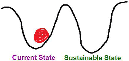
The difficulty of the transition has two main parts. One involves physical infrastructure. Our farms, buildings, and roads are largely set up for an unsustainable type of development. Transitioning to sustainable development would require rebuilding a lot of this. That’s a lot of work! Even if more sustainable infrastructure ends up being eventually more pleasant or less expensive to operate, it is often more expensive over the short-term. Indeed, discussions of sustainable development often highlight the concept of the break-even point, which is the point in time in the future in which an investment in more sustainable physical infrastructure breaks even. Before the break-even point, the investment loses money (or whatever else is being counted). After the break-even point, the investment makes money/etc. For example, we might spend more money constructing a more energy-efficient building, but over the course of the building’s lifetime, we save money on energy costs.
The other part of the difficulty of the transition is cognitive. Simply put, our minds require some transition, too. Part of the cognitive transition involves learning some new things. If we’re going to eat foods with lower environmental impacts, then we need to learn to use some new recipes or restaurants. If we’re going to use different transportation modes, then we need to learn how to use those. But part of the cognitive transition goes beyond learning. This involves habits and social norms. We might know full well how to cook a meal or get around town in a more sustainable manner, but we still find ourselves in the habit of doing the same things we always have been doing. Changing habits can be a very difficult thing to do. Or, we might be able to change our habits, but find ourselves in social circumstances in which the new habits are not considered normal. Maybe your friends are all going out for hamburgers or buffalo wings and would tease you if you ordered a vegetarian option. Maybe your family doesn’t want to move to an area where you and they could walk everywhere. In scenarios like this, it’s entirely possible that the other people in your social group would be more positive and accommodating after they went through a cognitive transition of their own. Either way, it remains the case that social norms can make transitions to sustainability – or to anything else, for that matter – more difficult. The same can be said for the other aspects of cognitive transition: learning and habits.
The challenge of transition makes achieving sustainable development quite a lot more difficult. But the challenge also opens up opportunities. Today, many people are employed in various aspects of sustainable development largely to facilitate the transition. Whether you’re in engineering or advertising, farming or law, or virtually any other profession, there are opportunities to help with the transition to sustainable development. Succeeding with this involves understanding the interconnections between your profession and sustainability.
And with that, our sustainable development unit comes to an end.
Our third and final unit, global environmental change, explains why the transition to sustainability is so important. In short, the fate of the global human-environment system is at stake, including our very survival. So, while sustainable development can be pleasant, and the transition can be difficult, the transition is also quite important. Arguably, nothing at all is more important.
Summary
Summary
Cities and transportation are central to contemporary development because they enable large numbers of people to come together for specific purposes. Food is important because everyone eats it, and agriculture is important because it's how we get most of our food. This module was designed to present urban transportation and farming in a systemic, geographic perspective with emphasis on their sustainability. Urban landscapes are heavily dominated by human activity but are nonetheless influenced by environmental features such as the presence of ports. Urban design in turn influences which modes of transportation we use, as seen in urban areas designed for pedestrian, public transit, and automobile transportation. Cities and transportation impact the environment in several ways, including energy use and air quality. By minimizing food transport and carbon footprint, urban farming makes cities less fossil-fuel dependent and more environmentally-friendly. Finally, there are efforts in cities around the world to transition towards sustainable development.
The transition to sustainability can be difficult. The transition is often more difficult than the end result of being in a more sustainable state. Transitions to sustainability can involve transitions in both physical infrastructure and in our own minds. The challenge of the transition is an important aspect of sustainable development, one which can present opportunities for those interested in pursuing sustainable development in their lives.