…nearly everybody has a creek gurgling through their memories, a confiding waterway that rose in the spring of youth.
Peter Steinhart, The meaning of Creeks. Audubon, May 1989, p.22-23
Gaining an understanding the sources of water is fundamental to learning about water resources. Lessons 2 and 3 focus on the three primary sources of freshwater; precipitation and surface flows (Lesson 2), and groundwater (Lesson 3). In reality, of course, these sources comprise a highly integrated system known as a hydrologic cycle, which is a conceptual model representing both storage of water (referred to as reservoirs or pools), and the flows or exchanges between those reservoirs.
In Chapter 2 of the text, the important terms evapotranspiration, interception, and condensation are described. Formal definitions can be found in the text's glossary, beginning on p.351. Further information is available from the USGS weblink listed in Lesson 1.
Water vapor in the atmosphere modulates the adsorption and emission of infrared radiation, representing the heat generated by solar radiation. As we will see in Lesson 5 on climate types, the tropics receive about twice the amount of solar radiation as polar regions, and thus, the natural global energy budget flows from the tropics along the equator toward both poles. Circulation patterns of water vapor in the atmosphere are the major driver of that energy cycle (60%), along with oceanic currents (40%) (Stevens 2011, from Sitch and Drake 2014, Chapter 2).
As we learned in Lesson 1, the phase changes among the liquid, solid, and gaseous states of water govern these processes. When water evaporates from the surfaces of soil, vegetation, or liquid water, energy is absorbed. When the reverse process occurs through condensation, energy is released as water vapor reverts to liquid water (a characteristic known as the latent heat of vaporization, Sitch and Drake 2014). When surfaces cool, water vapor condenses, producing dew (changing from a gas to a liquid). When this occurs in the atmosphere, the condensing water vapor eventually becomes a form of precipitation (i.e., rain, snow, sleet, etc.). As precipitation falls, it may be intercepted by plant or land surfaces before flowing across the ground to a body of water, or infiltrate into shallow or deep groundwater.
Differential patterns of precipitation across the Earth's surface, driven by these complex interactions between energy and water, create weather and ultimately define climate (further considered in Lesson 5). Climate variability, then, ranges between fairly predictable temperature and precipitation conditions and less predictable extremes, such as horrific storms and severe drought. Although not a major topic for this course, water vapor's influence on the natural greenhouse effect, estimated to be 60% (Kiehl and Trenberth 1997, from Sitch and Drake 2014), is exacerbated by release of human-generated greenhouse gases, primarily from burning of fossil fuels. Refer to the most recent reports of the Intergovernmental Panel on Climate Change (IPCC, 2022, http://www.ipcc.ch/) for additional information.
Evapotranspiration is comprised of two interacting processes, the physically-based evaporation of water from surfaces, and the biologically-mediated transpiration of water loss from the stomata (specialized cells) of vascular plants that allow the “escape” of liquid water to water vapor as a means of cooling leaf surfaces (see Lecture 2.1 PPT). Again, once water vapor from any source accumulates sufficiently in the atmosphere, precipitation occurs, returning liquid water to the oceans and land surfaces.
Why is this critically important to patterns of freshwater use (coming up in Lessons 7 and 8)? Because over 50% of the world's potable water comes from rivers – the water people consume. So, let's turn our attention to Chapter 3, to examine the hydrologic behavior of flowing waters in rivers and streams.
Rivers and streams, and their associated floodplains, are common delivery systems for moving freshwater across a landscape to receiving bodies of water, basins, or the oceans. Thus, we will focus more on riverine systems than lacustrine (lakes) or palustrine (vegetated wetlands) systems. The readings and Lectures 2.1 and 2.2 PPTs were chosen to familiarize you with how river systems function across the globe. They provide important habitats for a tremendous variety of species of plants and animals, fish being perhaps the most obvious water-dependent group. They also serve human needs by providing water supplies for drinking, agriculture, wastewater, energy and industrial needs, transportation, and recreation. Extreme events, such as floods and droughts, unfortunately, cause destruction to natural ecosystems, property damage, and loss of human life. Floods are created by high volume rainstorms or snowmelts, or by ocean-generated storms such as hurricanes and typhoons. Droughts, essentially a severe shortage of rainfall or snowmelt over extended periods of time, can damage the same systems, but in different ways. The Lecture 2.2 PPT provides an overview.
The importance of the headwater portions of watersheds to the overall health of aquatic ecosystems in many regions cannot be overemphasized. For example, in the Mid-Atlantic Region of U.S., in the area surrounding Washington, DC, headwaters typically comprise about 67–75% of the contributing area of any given watershed. That is, the combined areas of terrestrial habitats, wetlands, floodplains, and headwater streams occupy two-thirds to three-quarters of the total area of the drainage basin for larger rivers (Brooks et al. 2013). Given this influence on downstream portions of large river watersheds, understanding the impacts of human activities on the ecological structure and function of headwater or tributary portions of watersheds is foundational for optimizing their conservation and management. It is also critically important to understand the linkages and contributions of headwaters to the downstream portions of watersheds where large rivers and broader floodplains dominate.
Increasingly during the past decade, ecologists and hydrologists have moved toward integrating the traditional studies of the upstream–downstream gradient of rivers to produce a more comprehensive view of all the aquatic components of watersheds, and their interactions with terrestrial areas (Fig. 2.1, Brooks et al. 2013). The dimensions of these systems include: longitudinal or first dimension, river channel, streambanks) with lateral or second dimension (e.g., floodplains, riparian corridors, wetlands) and vertical or third dimension (e.g., groundwater flows, hyporheic zone) portions. As you work through the materials, try to visualize how water flows through this ecosystem from a 3-dimensional spatial perspective, and with regard to time. When you are in the field, near a stream, lake, or wetland, try to conceptually imagine how water is supporting and flowing through that system. As you begin to understand the principles that explain surface and groundwater flows between the river channel and other components of the riverine ecosystem, your understanding of how hydrological and ecological processes operate in rivers, and how they affect human use of these vital resources, will come into focus.
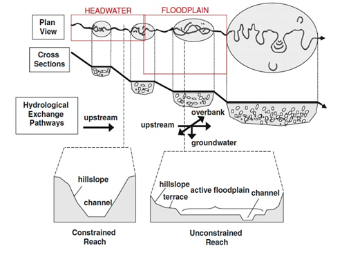
The separation of aquatic components of watersheds is common in regulatory and management contexts where streams and rivers are treated as separate entities from lakes, wetlands, and estuaries. In the past, such a separation was more for the convenience of defining and managing these units, than it was based on any ecological principles. There are important hydrological and ecological linkages between streams, rivers, and their adjacent floodplains and wetlands, together, comprising a riverine ecosystem. When the interactions with terrestrial components are considered, a holistic aquatic landscape or watershed can be visualized. Increasingly, syntheses in the literature have begun to move beyond the stream or river channel alone, to incorporating linkages between rivers and the landscapes in which they flow, thus recognizing longitudinal, lateral, and vertical aspects of the riverine network (Brooks et al. 2013). We begin focusing on this theme of integrating waters here in Lesson 2, and we will further develop it in Lesson 3, especially for Assignment 3.1.
Perusing the readings for Lesson 2, in the order listed, will have you progress from how precipitation and surface flow sources are generated, and how they are manifested in riverine systems (Chapters 2 and 3 of Holden, 2014). Chapter 4 covers surface water quality in some depth. It can be skimmed to become familiar with the types of stressors that degrade water quality. The last reading covers the integration of waters, primarily for the Mid-Atlantic Region of the U.S., but it provides a thorough background, and extensive literature citations, for comprehending current thinking about riverine systems, especially with regard to hydrology, energy flow, and the three components of water quality – physical, chemical, and biological.