Lesson 5: Climate Types
The links below provide an outline of the material for this lesson. Be sure to carefully read through the entire lesson before returning to Canvas to submit your assignments.
Overview
Understanding where climate types are located is critically important for understanding the distribution patterns of freshwater on Earth. First, read through Lesson 5 and explore the listed web links, which will further your understanding of five drivers of climate. Then, review the accompanying Lecture 5.1 - Climate Types.
The Microsoft PowerPoint presentation provides a summary of the characteristics of the six major climate types, as defined by the Köppen system, with photographs to illustrate most types. From this PPT, you should learn generally where the major climate types occur, and what factors influence their locations. Refer to the Köppen map to help visualize their latitudinal positions relative to the equator. You need to grasp the general location and influence of global atmospheric and oceanic currents which, when combined with the five drivers, determine where to find these major climate types. Figures 1 and 2, and Table 1 provide supplementary information that will help you visualize how climate types are formed and where they occur.
Note:
The course text, Holden 2020, does not cover this topic, so use the following text and the listed websites to learn about the Köppen Climate System.
Learning Outcomes
By the end of this lesson, you should be able to:
- explain the importance of latitude, temperature, precipitation, topography, and soil as drivers of hydrology based on Köppen climate types on Earth.
- explain the effects of atmospheric oceanic circulation and currents, and continental features on worldwide distribution of freshwater, driven in part by Hadley Cells and the Inter-Tropical Convergence Zone.
Lesson Roadmap
This lesson is one week in length. Please refer to the Course Calendar in Canvas for specific time frames and due dates. To finish this lesson, you must complete the activities listed below.
| Requirements | Assignment Details | Access/Directions |
|---|---|---|
| To Do | Read the Overview section and work through the material of Lesson 5. | You are on the overview page of the Lesson 5 online content now. Use the links at the bottom of the page or the Lessons menu to proceed to the next page. |
| To Watch |
Watch/Read through the Lesson 5 – Climate Types PowerPoint file. |
Registered students can access the PPT files under Lesson 5 in Canvas. |
| To Read | As noted above, the course text does not cover this topic, so use the lesson text and the listed websites to learn about the Köppen Climate System. |
The lesson text contains links to websites you can use to learn about the Köppen Climate System. |
| To Do |
Discussion #2 - Water Science Communication |
Submit your post and replies under Discussion #2 in Canvas |
Questions?
If you have any questions, please post them to our Questions? discussion forum located under Orientation and Resources in Canvas. While you are there, feel free to post your own responses if you, too, are able to help out a classmate.
Credits
GEOG 431 Lesson 5 – Climate Systems - Authored by Jenna Thomas and Robert P. Brooks, Ph.D., Department of Geography, The Pennsylvania State University, 2014. Material adapted *Elemental Geosystems* by Robert Christopherson, and information gleaned from the websites listed.
Background
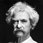
Climate is what you expect, weather is what you get.
Mark Twain
(Samuel Clemens, 1835-1910)
American author and humorist
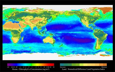
Climate controls the biomes of our world. It explains why we have luscious, green tropical rainforests in some regions and arid, barren deserts in others. Climate is the variability and variation in weather for a particular region over time. This includes regular weather conditions as well as extremes. Temperature and precipitation are two of the main factors influencing climate, but latitude, topography, and soil also affect climate. Climate helps to explain the distribution of plants, animals, and soils around the world, and is obviously critically important for understanding the distribution patterns of freshwater on Earth.
The Köppen Climate Classification System divides the world into five major climate types based on average monthly temperatures, average monthly precipitation, and total annual precipitation. It is the most widely used system for climate classification. The five major types of climates are designated by the capital letters, A, B, C, D, E, or H. A - represents humid tropical climates, B - represents dry climates, C - represents mild mid-latitude climates, D - represents severe mid-latitude climates, E - represents polar climates, and H – represents highlands or mountainous areas, where climate can vary due to elevation or slope aspect differences. These categories are then subdivided based on temperature and precipitation, and borders between regions represent transition zones between climate types (see Table 1 at the end of the lesson for detailed subtypes).
The German climatologist and amateur botanist Wladimir Köppen(1846-1940) introduced this system in 1928, which was co-authored with his student Rudolph Geiger. Köppen continued to update their system until his death. It remains the primary climate classification system in use in the world today. Kottek et al. (2006) provides a recent update (Figure 5.1).
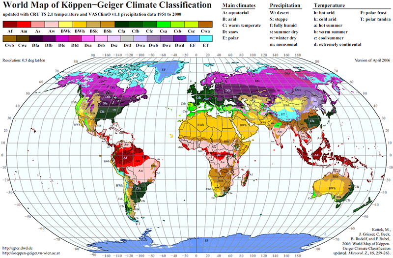 [1]
[1]
World Map of the Köppen-Geiger climate classification updated.
Meteorol. Z., 15:259-263. DOI: 10.1127/0941-2948/2006/0130.)
To further understand how the Köppen climate types are formed, it is important to become familiar with global atmospheric and oceanic currents. Global winds drive the surface ocean currents, which also are influenced by the Coriolis Force caused by Earth’s rotation. The Inter-Tropical Convergence Zone (ITCZ) is a part of the global circulation system that generates large amounts of precipitation. It is a low- pressure zone near the equator that is caused by the convergence of trade winds. This convergence results in a stagnation of winds, even though the actual location of the ITCZ varies from year to year. This shifting in location helps to create the wet and dry seasons of the tropics. It is sometimes known as the thermal equator. The systems that create these trade winds are known as Hadley Cells. These cells are formed when warm air rises near the equator and moves towards the poles. This warm air is a result of the sun’s uneven insolation, so the tropical regions absorb more heat than they reflect, compared to the surrounding regions (Figure 5.2).
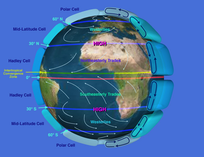
In Figure 5.2, the Earth is rotating left to right, or eastward, in this figure, creating the Coriolis Force, which drives, in part, the “spin” of these currents. This can be seen by the directional movement of the trade winds in both the northern (clockwise, right) and southern (counterclockwise, left) hemispheres. The ITCZ varies in its position around the equator by season and as a consequence of atmospheric and oceanic currents. The Hadley Cells form as hot, moist air rises in the vicinity of the equator. Other cells, somewhat weaker, set up similar patterns toward the poles. More information can be found on the web links on the following Resource Material page.
Resource Material
As mentioned on the Lesson 5 overview page, the course text, Holden 2014, does not cover the Köppen Climate System topic, so use the following material and the listed websites to learn about the Köppen Climate System.
Köppen Climate System
- PhysicalGeography.net - Climate Classification and Climatic Regions of the World [3]
- Köppen Climate Classification System | National Geographic Society [4]
or
Registered students can access the KoppenClimateClassification(elmhurst).pdf file under Lesson 5 in Canvas.
Hadley cells and the Inter-tropical Convergence Zone (ITCZ)
Weather / Climate
Weather is the condition of the atmosphere at any given place and time, and the variability of this weather over time is climate. Climates greatly influence ecosystems, and these ecosystems are grouped together to form biomes. Each biome has associated plant, soil, and animal communities. The various climate components include insolation, temperature, air pressure, air masses, and precipitation. Temperature is mainly controlled by latitude, altitude/elevation, and cloud cover.
Climatology is the study of climates and it analyzes weather patterns over time and space. There are six basic climate categories:
- Tropical = equatorial and tropical latitudes
- Desert = permanent moisture deficits
- Mesothermal = midlatitudes and mild winter
- Microthermal = mid- and high latitude, cold winter
- Polar = high latitudes and polar regions
- Highland = lower temperatures compared to lowlands at same latitude
Köppen
The Köppen system uses capital letters (A,B,C,D,E,H) to designate climatic categories from the equator to the poles. Categories A, C-H are based off of thermal characteristics, and B is based off of moisture as well. Within each climate classification lowercase letters signify temperature and moisture conditions. See table 5.1 below.
- A = Tropical
- B = Desert (arid, dry)
- C = Mesothermal
- D = Microthermal
- E = Polar
- H = Highland
The link below shows the different Köppen climate types around the globe. You can select a region of interest to learn more about the climate type that you chose.
Required Viewing
An illustrated Microsoft PowerPoint presentation (GEOG 431 Lesson 5 PPT) is provided to introduce you to the places and appearance of the major climate regions (Brooks 2014).
Registered students can access the GEOG 431 Lesson 5 PPT file in Canvas.
Köppen uses average monthly temperatures, average monthly precipitation, and total annual precipitation to devise its spatial categories and boundaries. These boundaries serve as transition zones of gradual change between two climate systems. Drawbacks of the modified Köppen system include that it does not consider wind, temperature extremes, precipitation intensity, quantity of sunshine, cloud cover, or net radiation.
Climographs
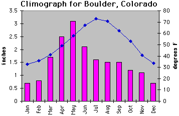
A climograph shows the monthly temperatures and precipitation over a typical year, subdivided into months. Also, it can provide location coordinates, average annual temperature, total annual precipitation, elevation, the local population, annual temperature range, annual hours of sunshine, and a location map. For examples of temperature and precipitation graphs for the various climate categories, visit the site below. The temperature and precipitation graphs can be found below the description of the five major climatic types. Use these graphs, or similar ones, for addressing Assignment 5.1.c.
The differential heating patterns
The differential heating patterns on Earth’s surface cause winds, which circulate heat and moisture. These winds do not blow exactly in a north-south direction; instead they appear to be deflected toward the east or west by the Coriolis Force. This effect results in the tendency of moving objects to veer to the right in the Northern Hemisphere and to the left in the Southern Hemisphere. The winds approaching the equator from the Horse Latitudes appear to be deflected west and are called northeast or southeast trade winds.
These surface winds also impact and influence the major ocean currents. Ocean currents move in great circular gyres—clockwise in the Northern Hemisphere and counterclockwise in the Southern Hemisphere. Warm currents flow from the tropics along eastern continental margins; as they reach high latitudes, they are cooled, producing cold currents that flow down the western margins. Warmer currents can absorb increasing amounts of evaporated water. By later cooling and condensing this water clouds are formed. The following links below provide good visual illustration of different wind circulation patterns.
Example of one of many global oscillation patterns that influence weather and climate
Climate studies show that precipitation fluctuates on a five to seven-year cycle. Fluctuations appear to be triggered by an event in the vast tropical Pacific Ocean—El Niño Southern Oscillation, or ENSO. As the westerly winds pass over warm water, they pick up moisture and transport it to the adjacent continents, causing heavy precipitation in the winter when the land is colder than the offshore waters. This phenomenon is known as El Niño. ENSO events are also characterized by reduced coastal upwelling, which results in dramatic reductions in nutrients and ultimately affects the entire food chain of oceanic communities. The link below provides additional details on El Niño as well as graphs illustrating the changes in sea surface temperature.
| Type | Type Name |
Sub Type | Sub Type Name |
Characteristics |
|---|---|---|---|---|
| A | Tropical Humid | Af | Tropical wet | No dry season |
| — | — | Am | Tropical monsoonal | Short dry season; heavy monsoonal rains in other months |
| — | — | Aw | Tropical savanna | Winter dry season |
| B | Dry | BWh | Subtropical desert | Low-latitude desert |
| — | — | BSh | Subtropical steppe | Low-latitude dry |
| — | — | BWk | Mid-latitude desert | Mid-latitude desert |
| — | — | BSk | Mid-latitude steppe | Mid-latitude dry |
| C | Mild Mid-Latitude | Csa | Mediterranean | Mild with dry, hot summer |
| — | — | Csb | Mediterranean | Mild with dry, warm summer |
| — | — | Cfa | Humid subtropical | Mild with no dry season, hot summer |
| — | — | Cwa | Humid subtropical | Mild with dry winter, hot summer |
| — | — | Cfb | Marine west coast | Mild with no dry season, warm summer |
| — | — | Cfc | Marine west coast | Mild with no dry season, cool summer |
| D | Severe Mid-Latitude | Dfa | Humid continental | Humid with severe winter, no dry season, hot summer |
| — | — | Dfb | Humid continental | Humid with severe winter, no dry season, warm summer |
| — | — | Dwa | Humid continental | Humid with severe, dry winter, hot summer |
| — | — | Dwb | Humid continental | Humid with severe, dry winter, warm summer |
| — | — | Dfc | Subarctic | Severe winter, no dry season, cool summer |
| — | — | Dfd | Subarctic | Severe, very cold winter, no dry season, cool summer |
| — | — | Dwc | Subarctic | Severe, dry winter, cool summer |
| — | — | Dwd | Subarctic | Severe, very cold and dry winter, cool summer |
| E | Polar | ET | Tundra | Polar tundra, no true summer |
| — | — | EF | Ice Cap | Perennial ice |
| H | Highland | — | — | — |
Lesson 5 Activity
Deliverable
No assignments for lesson 5, focus on writing your discussion post.
Summary and Final Tasks
Summary
The purpose of Lesson 5 was to introduce you to climate types throughout the world, which are closely tied to moisture levels, and hence, freshwater resources. Working your way through this lesson, do you think you gained a new appreciation for the diversity of climate types and how places and people are influenced by those physiographic characteristics? I hope so, because having an appreciation for the availability of water resources in a specific geographic area can provide insight into business opportunities, environmental challenges, and ecosystem characteristics.
Reminder - Complete all of the Lesson 5 tasks!
You have reached the end of Lesson 5! Double check the to-do list on the Lesson 5 Overview [12] page to make sure you have completed all of the activities listed there before you begin Lesson 6.