As an introduction, this lesson includes the history and key concepts of the systems framework approach. A spatial system can be a method or an algorithm which fits with the definition of components which are connected together. A spatial system is also a framework, be it people, software, and/or hardware, of integrated entities performing spatial tasks. When you put the word information in front of system, the term information system refers to a system of people, data records and activities that process the data and information in an organization, and it includes the organization's manual and automated processes. A Geographic Information System (GIS) is a spatial system for capturing, storing, analyzing, managing and presenting data which are spatially referenced to the Earth. In the strictest sense, it is any information system capable of integrating, storing, editing, analyzing, sharing, and displaying geographically referenced information. In a more generic sense, GIS applications are tools that allow users to create interactive queries (user created searches), analyze spatial information, edit data and maps, and present the results of all these operations. Geographic information science is the science underlying the geographic concepts, applications and systems taught in degree and GIS Certificate programs at many universities.
If you have any questions now or at any point during this lesson, please feel free to post them to the Threaded Discussion Forum. (That discussion forum can be accessed at any time by clicking on the Communicate tab, above, and then scrolling down to the Discussion Forums section.)
To finish this lesson, you must complete the activities listed below. You may find it useful to print this page out first so that you can follow along with the directions.
| Step | Activity | Access/Directions |
|---|---|---|
| 1 | Read the lesson Overview and Checklist. | You are in the Lesson 7 online content now. The Overview page is previous to this page, and you are on the Checklist page right now. |
| 2 | Online Material (Read) | There are three different styles of reading that are referred to in the lessons:
|
| 3 | View the Lesson Overview. | You are in the Lesson 7 online content now. Click on the "Next Page" link to access the Lecture/Discussion. Foundations of Geospatial System Development |
| 4 | Geospatial Think-Piece (Template) [3] |
Using Word (or a word processing program compatible with Microsoft®), identify and briefly discuss (<200 words): what is unique about designing a geospatial system (GIS)? |
| 5 | Read lesson Summary. | You are in the Lesson 6 online content now. |
This following page presents a historic summary number of methodologies created specifically for use in the design and implementation of Geographic Information Systems. They were developed so that issues specific to GISs were formally addressed: issues that were not addressed in general software design models of the time.
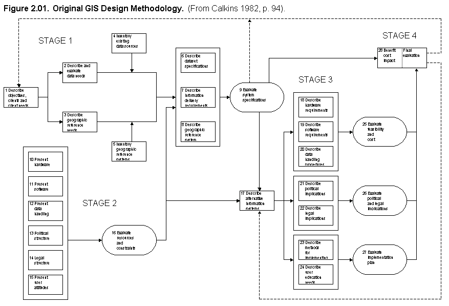
The first design methodology specifically for GISs was presented in 1972 by Roger Tomlinson (See figure 2.01 [4]) (Calkins 1982, p, 92). The methodology follows a traditional, linear waterfall model structure. The steps are broken down into four stages, each proceeding in sequence. The four stages of the methodology are described below.
Stage one begins with an assessment of the vision and goals of the project. The second step of this stage defines the organization's functional needs and requirements followed by the identification of data needs. Stage one concludes with the definition of specifications for the objective system. The steps of stage one reflect the first three steps of the traditional waterfall model. A feedback mechanism is shown that returns the project back to the beginning. This feedback mechanism allows the specifications to be compared with the initial definitions of objectives and requirements.
Stage two is a departure from the traditional waterfall model. The steps in this stage identify the current situation of the organization. These include hardware and software resources and the culture and structure of the organization. These steps identify the resources and constraints of the GIS project.
Stage three involves the comparison of the system specification derived in stage one with the resources and constraints identified in stage two. Necessary modifications are made to the initial specification and a revised design of the system is derived. The implications of the system's implementation in the organization are assessed. A notable inclusion is step 24, which calls for the description of user education needs (See figure 2.01 [4]). This is an important step, which is often omitted. As exemplified by this model, consideration of the organizational context has been recognized as an essential component of GIS design and implementation from the beginnings of GIS-specific design methodologies.
The final stage, stage four, entails a final evaluation of the system. From this point, the project proceeds in one of three directions. The system can be implemented, if it is deemed satisfactory. The project can return to the first step of stage one to reassess the original requirements of the system. The other alternative path is to stage three, where an alternative system can be defined to meet the previously determined needs.
This methodology is straightforward and simple to follow. It has served as the starting point for the development of subsequent GIS design methodologies. However, this methodology contains certain characteristics that may lead to some of the problems.
In the initial definition of requirements, user involvement is not specified. This aspect of the methodology has led to a number of unsuccessful GIS design projects where requirements were not satisfactorily defined (Calkins 1982, p. 95). To obtain an adequate assessment of an organization's needs and requirements, representatives from all levels of the organization must be explicitly involved, users in particular.
A second problematic characteristic of this methodology is the placement of user education needs in a step toward the end of the design process. An organization cannot accurately assess its needs and requirements unless it has a knowledge of GIS concepts and capabilities. The education of all participating members of the organization must take place early in the process. Also, the diagram implies that users are regarded as outsiders to the process.
The feedback mechanisms in this methodology are important and necessary. Returning the process to the objectives and requirements definition is crucial to ensure that the project is on the right track. The feedback paths in this particular methodology can be improved upon, however. In this methodology, only the intangible specifications of the objective system are compared with the initial requirements; a physical product is not available. A tangible product gives users and other organization members an increased ability to assess the strengths of a system.
An issue related to the feedback mechanisms is the lack of a means for changing requirements if necessary. Often users will incrementally discover requirements during the process, particularly when they see a physical product. In this methodology, a change to the requirements would require repeating all of the steps from the beginning. Although this is possible, a great deal of time would be consumed. A feedback mechanism that allows for less time-consuming and disruptive requirements changes would be an improvement.
This methodology partially meets only two of the requirements: (1) an iterative feedback mechanism exists, however, it does not enable interaction with a tangible product; and (2) user education is specified, but not until step 24 toward the end of the process; participants may be inadequately educated during the early stages of the project. The other requirements (i.e., organization-wide participation, emphasis on communication, and effective group-work environments) are not explicitly addressed.
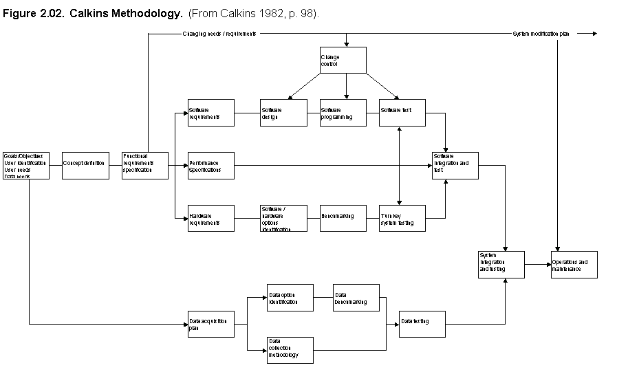
Hugh Calkins developed a methodology as a modification of the original 1972 methodology (Calkins 1982) (See figure 2.02 [5]). The Calkins methodology begins with the definition of objectives and requirements. The methodology then divides into two paths: one pursues issues of data, and the other pursues the issue of acquiring hardware and software. By dividing the methodology in such a way, a stronger emphasis is placed on the data requirements and needs. This is important because in a geographic information system the data is as important as, if not more important than, the hardware and software.
Aside from the separation of data from the hardware and software, the methodology follows the same general linear path as the original 1972 methodology. One striking difference is the omission of feedback mechanisms. At no point in the methodology is there an explicit return to the initial objectives and requirements. This opens the possibility that the final product may not be what was needed or expected. The lack of feedback mechanisms also denies users the opportunity to interact with the system and make changes to its specification, or more importantly, to the requirements.
Rather than feedback mechanisms, the Calkins methodology encourages continual user input throughout the process. Rather than iteratively modifying the system to accommodate changing user requirements, the Calkins methodology takes more of an incremental approach. Although not illustrated in the diagram, at each step of the process the system is evaluated by the users and minor changes can be made. This methodology, however, does not accommodate radical changes to the users' requirements. Rather, the idea in this methodology is to prevent the need for radical changes.
Calkins places strong emphasis on the involvement of users. This is an important and crucial factor. Changes that need to be made to the system commonly come from the users. Calkins acknowledges that changes will undoubtedly be necessary, and he states that a plan needs to be developed to deal with modifications after the system's implementation. This is an important strategy in any project. However, it is best to implement a system that meets the needs of the organization when it is first produced. Earlier sections have discussed the costly and time-consuming problems associated with significant backtracking in the process. A design methodology that accommodates change and the refinement of requirements before implementation is necessary.
This methodology explicitly addresses the participation of all levels of an organization. In particular, Calkins stresses the continual involvement of users in the design process. Other requirements (i.e., iterative discovery, communication emphasis, effective group-work environments, and education) are not formally presented in the Calkins methodology.
Marble and Wilcox developed a methodology that combines the Calkins methodology with concepts from software engineering and stresses the importance of involving all levels of an organization in the design process (Marble and Wilcox 1991). Figure 2.03 [6] indicates the different parties that Marble and Wilcox recommend for participation in the process. These parties include members from within the organization as well as external parties relevant to the process. The external parties supplement the expertise and knowledge of the organization. This expertise includes knowledge of specific GIS software and digital data products and knowledge of the design process itself. The interaction of all of these parties contributes to the success of a GIS implementation project.
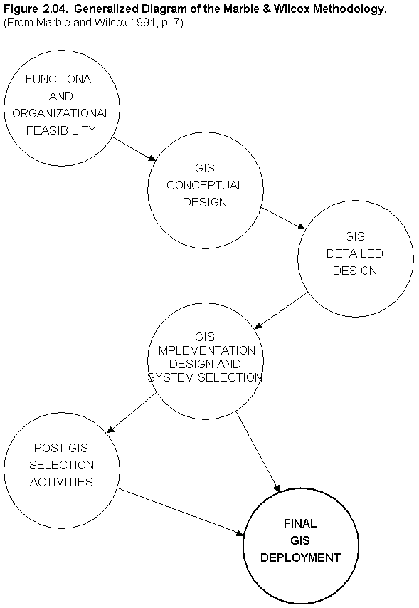
Figure 2.04 [7] is a generalized diagram of the Marble and Wilcox methodology. The first step of functional and organizational feasibility is emphasized in this methodology. During this step not only are the objectives and requirements for the system defined, but the organizational implications of the system are also assessed (Marble and Wilcox 1991). The role that the system will play in the organization, the impacts the system will have on its members, the need for and value of implementing a GIS, and other such issues are addressed and made known to all members of the organization. This process of planning for both the technical and organizational specifications and impacts greatly reduces the possibility of later difficulties.
The explicit identification of organizational factors is the cornerstone of a successful GIS implementation according to the Marble and Wilcox methodology. The general ordering is similar to the other methodologies, but the emphasis is distinctly different. Listed below are a number of the specific issues that are stressed in this methodology (Marble and Wilcox 1991, pp. 9-11):
The Marble and Wilcox methodology is significant with regard to its emphasis on the organizational aspects of GIS design and implementation. A factor that seems to be lacking, however, is a feedback mechanism to account for the incremental discovery of requirements. It is an overall linear process with no opportunity to return to the fundamental step of system objectives and requirements definition.
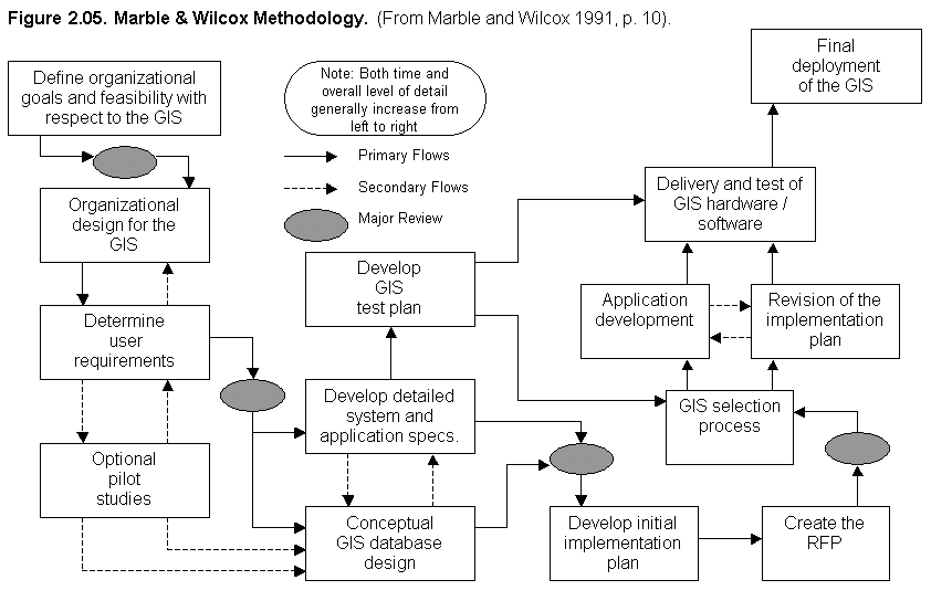
Figure 2.05 [8] shows a detailed graphical description of the methodology. In this diagram, a step for optional pilot studies is shown. The omission of this step introduces risk by not allowing for feedback and incremental discovery of system requirements. The pilot study step consists of a reduced version of the entire methodology, where a physical product is generated, usually consisting of a simplified database and some commercial GIS software package acquired for evaluation purposes. The users evaluate the pilot system and reassess their needs and requirements. Feedback mechanisms and the implementation of the pilot system are key means to ensure that the requirements are correct and the ultimately implemented system is appropriate.
The Marble and Wilcox methodology, however, lacks an explicit education process. As stated earlier, the users cannot accurately assess their needs unless they are acquainted with the technology and understand its concepts. An initial step that consists of training and education is essential for an accurate definition of requirements. The pilot system will also provide a significant amount of education for the users as they interact with the system.
Marble and Wilcox strongly encourage broad organizational participation and illustrate this in a diagram (see Figure 2.03 [6]). By emphasizing the participation of many participants, Marble and Wilcox also address the communication requirement. The iterative discovery requirement is only partially addressed by Marble and Wilcox. There is no significant feedback mechanism back to requirements definition; however, an optional pilot study is included. This pilot study, if required and made a more prominent component of the methodology, would yield a better definition of requirements. The requirements of effective group work environments and education are not explicitly addressed in this methodology.
Peuquet and Bacastow (Peuquet and Bacastow 1991) recognize the problems that linear waterfall models present in GIS development and propose the use of prototyping as the preferred alternative. Prototyping not only increases the accuracy of requirements definition, but also increases support and morale within the organization. This methodology is predominantly concerned with the issue of iterative discovery and refinement. They note the following:
"Putting a system in the hands of the users was also highly effective in developing critical support for topographic automation and challenging established procedures within the research and development community by, first, demonstrating the immediacy of the need for topographic automation to managers, and second, by raising the users' level of expectations simultaneously with their level of frustration at not having a complete system." (Peuquet and Bacastow 1991, p. 308)
Another significant benefit of the prototyping model is its responsiveness to change. Prototyping encourages and accommodates change as an inherent part of the process (Peuquet and Bacastow 1991, p. 371). Changes in user requirements and other factors during the design process are inevitable. A methodology that acknowledges this fact and accommodates change produces a superior product. Linear models do not accommodate change.
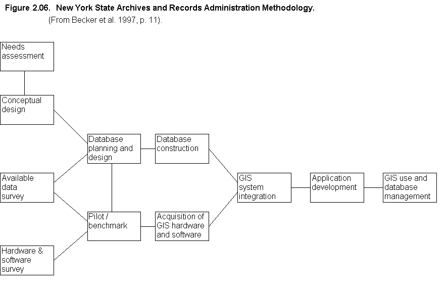
Other GIS design methodologies exist, some of which are geared toward very specific applications. The Local Government GIS Development Guides, produced by the New York State Archives and Records Administration, is one such methodology (Becker et al. 1999). This methodology describes a generalized model with specific procedures and activities describing each step.
Figure 2.06 [9] shows a diagram of the New York State Archives and Records Administration methodology. The methodology has a linear appearance but has a step for the production of a pilot or benchmark system, similar to the Marble and Wilcox methodology. This pilot step is advantageous, although this methodology, like the Marble and Wilcox methodology, does not allow for the reevaluation and change of user requirements.
Although education does not show up as a formal step in the methodology diagram, the procedures of this methodology call for the project participants to attend introductory GIS seminars and workshops and other means of acquiring GIS knowledge (Becker et al. 1999, p. 11). This education step should be explicitly denoted in the design diagram as an indication of its importance. As discussed earlier, education at the start of the process is critical to successful requirements definition.
Another note in the methodology procedure is that the order of the steps in the methodology is not important, but rather that the steps are accomplished, in the authors' words, "one way or another" (Becker et al. 1999, p. 12). The loose structure of the Local Government GIS Development Guides allows the design and implementation process to wander and leads to poor decisions due to a lack of proper preparation. This is particularly likely given the technical and organizational complexity of GIS projects. This is therefore a highly risky means of proceeding. Part of the reason for using a design methodology to guide a GIS project is to avoid an unstructured, wandering project. The structure of a methodology is just as important as its steps to help move projects toward a successful completion.
First, this lesson was an overview of the historic and foundational aspects of implementing a spatial system. Tomlinson's discussion is of importance since so many organizations focus only on the technical parts of implementing a computer system, and in the process don't really get the whole organizational picture of what is unique about spatial system and waste a great deal of time and money. A main theme through this lesson is that spatial system design is a team sport..
Second, the lesson introduced the role of systems analyst along with other stakeholders in the context of systems analysis and design. It also introduced the building blocks of Zackman’s Framework for Information Systems Architecture and is compatible with the idea that a system consists of four distinct layers: data, logic, presentation, and networks. These layers become the basis for distributed spatial systems which partitions or distributes various aspects of each of the first three layers (data, process, and interface) across the fourth layer (networks). Whitten’s Chapter 3 provided an introduction to the principles and processes used to develop information systems.
Links
[1] https://www.e-education.psu.edu/geog468/sites/www.e-education.psu.edu.geog468/files/NEW_Lesson_7/Foundations3.1.ppt
[2] https://www.e-education.psu.edu/geog468/sites/www.e-education.psu.edu.geog468/files/NEW_Lesson_7/Foundations4.2.ppt
[3] https://www.e-education.psu.edu/geog468/sites/www.e-education.psu.edu.geog468/files/Misc/Think-Piece%20Template.docx
[4] https://www.e-education.psu.edu/geog468/sites/www.e-education.psu.edu.geog468/files/L02_01.gif
[5] https://www.e-education.psu.edu/geog468/sites/www.e-education.psu.edu.geog468/files/L02_02.gif
[6] https://www.e-education.psu.edu/geog468/sites/www.e-education.psu.edu.geog468/files/L02_03.gif
[7] https://www.e-education.psu.edu/geog468/sites/www.e-education.psu.edu.geog468/files/L02_04.gif
[8] https://www.e-education.psu.edu/geog468/sites/www.e-education.psu.edu.geog468/files/L02_05.gif
[9] https://www.e-education.psu.edu/geog468/sites/www.e-education.psu.edu.geog468/files/L02_06.gif