Lesson 4 - Facilitating Public Participation with GIS
An Overview of Lesson 4
In this lesson, we’ll consider what it means to involve the public in decision-making processes like choosing routes for electric transmission lines. You’ll also learn more about how GIS can facilitate public participation, and even about the limitations of GIS analysis as a consensus-building methodology.
What will we learn in Lesson 4?
By the end of this lesson, you should be able to:
- understand all of the educational objectives of the two units in Geographic Information Science and Technology report;
- define environmental equity and environmental justice;
- identify and discuss four kinds of equity;
- discuss the claim that environmental equity is an inherently geographic problem;
- evaluate the status of research on environmental equity at the time the article was written, and consider how to evaluate its current status;
- evaluate the level of public participation in a case study using the Spectrum;
- evaluate the level of public participation in a case study;
- learn the basic operations of the Esri ArcMap system by meeting all of the requirements of the "Learning ArcGIS" and "ArcGIS Essential Training" courses via Lyndia.com.
GIS is one of the central technologies in the multidisciplinary research field known as “Geographic Information Science and Technology” (GIS&T). In 2006, the University Consortium for Geographic Information Science (UCGIS) published a “GIS&T Body of Knowledge” to help define the field. Two of its 329 topics focus on public participation. This lesson addresses several of the educational objectives of those two units, which are outlined below.
Topic GS3-2 Public participation in governing
- Differentiate among universal/deliberative, pluralist/representative, and participatory models of citizen participation in governing.
- Compare the advantages and disadvantages of group participation vs. individual participation.
- Describe the six “rungs” of increasing participation in governmental decision-making that constitute a “ladder” of public participation.
- Describe the range of spatial scales at which community organizations operate.
- Describe an example of “local knowledge” that is unlikely to be represented in the geospatial data maintained routinely by government agencies.
- Defend or refute the argument that local knowledges are contested.
- Explain how community organizations represent the interests of citizens, politicians, and planners.
- Explain and respond to the assertion that “capturing local knowledge” can be exploitative.
- Explain how legislation, such as the Community Reinvestment Act of 1977, provides leverage to community organizations.
Topic GS3-3 Public Participation GIS
- Explain how geospatial technologies can assist community organizations at each rung of the ladder of public participation.
- Explain why some community organizations may encounter more difficulty than others in acquiring geospatial data from public and private organizations.
- Explain how community organizations’ use of geospatial technologies can alter existing community power relations.
- Critique the assertion that public participation GIS promotes democracy.
- Explain the challenge involved in representing local knowledge that is not easily mapped or verified within current GIS software.
- Discuss advantages and disadvantages of six models of GIS availability, including community-based GIS, university-community partnerships, GIS facilities in universities and public libraries, “map rooms,” Internet map servers, and neighborhood GIS centers.
What is due for Lesson 4?
This lesson will take us one week to complete. Please refer to the Calendar for specific time frames and due dates. Specific directions for the assignments below can be found in this lesson.
- Lesson 4 Quiz
- Discussion assignment
- Submit your Certificate of Completion for the Esri "Getting Started with ArcGIS Pro" course if you haven't already done so.
- Answer a short answer essay quiz reflecting on the ArcGIS course you completed if you haven't already done so.
- Extra Credit opportunity
Questions?
If you have any questions, please post them to our Questions? discussion forum. I will check that discussion forum daily to respond. While you are there, feel free to post your own responses if you, too, are able to help out a classmate.
DiBiase, D, M. DeMers, A. Johnson, K. Kemp, A. Luck, B. Plewe, and E. Wentz, Eds. (2006). The Geographic Information Science and Technology Body of Knowledge. University Consortium for Geographic Information Science. Washington, DC: Association of American Geographers.
Environmental Justice
To frame our consideration of public participation GIS, let's first consider the concepts of “environmental justice” and “environmental equity.”
Watch this!
To get a feel for these concepts, watch the 9-minute video “Chester Environmental Justice”:
PROTESTER 1: Go stand in line. Stand in the line. Somebody get back in the line.
PROTESTER 2: Get it out of here!
PROTESTER 3: We live here, we're tired of the trash. So you need to go back where you were, and just tell them we wouldn't let you in. It's not your fault.
PROTESTER 4: That's just what I'm telling him.
PROTESTER 3: You're just caught up in the middle--
PROTESTER 4: --that's right.
PROTESTER 3: --but you ain't getting in there today.
Note on screen: In 1992 residents of Chester, PA, came together to fight against polluting waste facilities in their communities.
MAN 1: I don't know what's coming from that plant, but it's a stench that you've never smelled before. It is horrible.
WOMAN 1: We have a high rate of cancer here. We have a high rate of leukemia here. We have high rates of a lot of things that we don't have answers to.
MAN 2: Trash finds its way from Maryland. Trash finds its way from Virginia. Trash finds its way from Jersey to Chester.
MAN 3: When the plants come here, they're bringing us jobs. You're bringing us jobs, but at the same time, you're killing us.
MAN 4: Lord like I said, as long as--
MAN 3: --They're setting us up for defeat--
MAN 4: --as long as they're making their money they don't care. WOMAN 2: All they're going to do is be successful in driving away people like me who have the ability to stay here to pay the taxes, to buy the homes. They're going to drive us the hell out of here. And those of us that they don't drive off, they're going to kill them, slowly.
AUDIENCE MEMBER: If they put another plant in Chester, we will tear it down. Red-handed.
[APPLAUSE]
Note on screen: In the past 12 years there have been victories, but the time has come to fight again.
WOMAN 3: They said to us that they weren't going to bring any more of this type of industry into Chester. And now they're sneaking it in.
WOMAN 4: You still have other companies coming in. A lot of them are from out of the country, overseas. Names that are disguised. Trying to move in and get permits.
MAN 5: There are proposals for what would be the world's largest tire incinerator and other waste to fuel schemes that are targeting the city.
WOMAN 3: Because we are black, we are poor, low economics, low jobs. They think this is the ideal place to come and dump their trash and waste.
MAN 5: It's actually become known as one of the nation's worst cases of environmental racism. And we're trying to figure out ways to get the community reorganized, like we had in the mid '90s, to be a powerful force for change and make sure that those things get stopped.
MAN 2: There was a time in Chester where a person could quit a job, walk down the street and get another job that same day. That was the industrial boom. We had the ship building down here. It was a town where you saw people getting up in the mornings, going to work. You saw people working in three shifts. And it was just a real moving town. All of a sudden, things began to change. Industry world began to change, began to move out. A lot of things in the city were done wrong politically, and businesses and industry were basically sold off or sold out. And now we live in a city where industry is not booming, where jobs are scarce. So we're encouraging everything and anything to come into the community to provide jobs for the citizenship.
[APPLAUSE]
[SHOUTING]
PROTESTER 3: I said you need to understand that we're not going to move. And if you keep going forward, you're going to run over somebody because we're not moving.
MAN 6: I'd like to extend an official apology to the community for this type of action. Because he jumped in the truck and he drove the truck. And then I understand he almost hit somebody. There will be a more official statement coming from our corporation as soon as possible.
The purpose of this facility is to process or burn the county's trash. We are capable of processing 2,688 tons of trash per day. That's a lot of trash.
WOMAN 2: The is the office of Chester Residents Concern for Quality Living. We're a grassroots organization that has been fighting environmental injustice in our city.
Because it's going to take that kind of personal effort for people to become knowledgeable about this problem. You know what, they think that it's only an isolated thing. It only affects a certain portion of Chester. Which is a lie. It affects all of us. We're dealing with a lot of different issues. We're dealing with some environmental problems. We also have to deal with the governmental aspect of it, because that's what got us some of these environmental problems.
The economic benefits that they give the city are negated by the war that they have caused on our health.
AUDIENCE MEMBER: I have all kinds of health problems within the church community. And you know what, I've been going to these kind of meetings for 30 years. And I've seen all the games. I know how they're played, and I know that the players aren't here.
MAN 8: Just let me say, and then I'll turn to Ms. [INAUDIBLE] to respond, this problem is not going to be solved if you rely on other people to solve it. Now I'm saying things that I could not say when I was the administrator of EPA. If Mr. McCade could do it, I'm sure he would. He can't. If Ms. [INAUDIBLE] would do it, I'm sure she would. She can't. There are sources and powers higher than both of them.
WOMAN 2: We have found out that-- and it has taken us three and a half years to determine-- what is the force, who is the force, who is the faction, that has been behind these companies coming to our little teeny city in Chester. We don't want it. Hell no. We don't want it. It is that basic. It's that basic. It is that basic.
[APPLAUSE]
We have a terrible problem in Chester. We would like to speak to the people who are bringing the waste facilities to our city. We want to get them stopped.
MAN 9: This is a legal matter. It should be dealt with--
WOMAN 2: --It's a moral matter. It's something that you wouldn't want done to your worst enemy.
MAN 9: It's a moral matter that may have to be dealt with legally. But in any event, this is not--
WOMAN 2: --If you know how it'll be done, it's being dealt with our blood--
MAN 9: --You're wasting your time--
WOMAN 2: --Well it's OK--
MAN 9: You're wasting your time--
WOMAN 2: --We've got it to waste.
MAN 10: I think there was a lack of foresight to build a facility of this size so close to residences. It doesn't make people feel comfortable to know that the fourth largest resource recovery facility in the nation is right in their backyard. It's something that will still need to be dealt with.
Note on screen: In 2008, 12 years later, the incinerator continues to burn thousands of tons of trash every day. A number of new facilities are now proposed for Chester, including the world’s largest tire incinerator.
WOMAN 3: It's just important that we continue to fight this battle. And that is why I am just so involved, and so excited that we're back on the battlefield again.
Note on screen: In 2007 the DelCo Alliance for Environmental Justice was formed by members of the community to continue the fight. To get involved, contact the Alliance at: http://www.ejnet.org/chester/ [1] or (484) 302-0385.
WOMAN 2: It is not a person out there that can shake them, that could tell me that my life is insignificant. It would just never happen.
Note on screen: This video includes a section of the documentary “Laid to Waste” 1996 by R. Bahar and G. McCollough. Used with permission. Images from 2007 were filmed by advocates of the DelCo Alliance for Environmental Justice. The complete documentary “Laid to Waste” is available to universities, colleges, and libraries at https://www.berkeleymedia.com/product/laid_to_waste/ [2].
Reading Assignments
Reading assignment 1
After you’ve watched the video, read the article “Race, Class and Environmental Justice” by Susan Cutter, located in the Lesson 4 folder. [This article can also be accessed through a local library. The full citation is: Cutter, Susan L. (1995). Race, class and environmental justice. Progress in Human Geography 19(1), 111-122.]
Read, don’t just skim the article. It should take you only 35-45 minutes to read carefully and take notes. Here are some of the things you should learn by reading the article. You’ll be quizzed on these objectives at the end of the lesson.
- Define environmental equity and environmental justice.
- Identify and discuss four kinds of equity.
- Discuss the claim that environmental equity is an inherently geographic problem.
- Evaluate the status of research on environmental equity at the time the article was written, and consider how to evaluate its current status.
Reading assignment 2
Visit the EJSCREEN: EPA's Environmental Justice Mapping application [3] website.
- Read how to use the application and then enter your home location to determine if EJ impacts are nearby.
- Explore the Table of Contents on the right hand side to see information about EPA regulated sites, health statistics, demographic statistics and much more.
Optional reading
The United States Environmental Protection Agency Environmental Justice page [4]. This page is a gateway to environmental justice activities administered by the USEPA.
An excellent series on Environmental Justice presented by "Environmental Health News".
- Pollution, Poverty [5]and [5] People of Color: Living with Industry [6]
- Pollution, Poverty and People of Color: Children at Risk [7]
- Pollution, Poverty and People of Color: Don't Drink the Water [8]
- Pollution, Poverty [9]and [9] People of Color: A Michigan Tribe Battles a Global Corporation [9]
- Pollution, Poverty and People of Color: Falling into the Climate Gap [10]
- Pollution, Poverty [6]and [6] People of Color: Asthma and the Inner City [6]
- Pollution, Poverty [11]and [11] People of Color: Dirty Soil and Diabetes [11]
- Pollution, Poverty [12]and [12] People of Color: Can Multiculturalism Create Environmental Justice? [12]
Levels of Public Participation
Just how involved should the public be in decisions like where to put a 100Kv electric transmission line, or an incinerator, or a hazardous waste storage facility? Professional planners and others have thought about this question for a long time.
A milestone in this vein of planning scholarship was Sherry Arnstein’s article "A Ladder of Citizen Participation [13]." In it, she describes eight “rungs” or levels of participation, from “nonparticipation” at the lowest rung to “citizen control” at the top. (The full citation of the original published article is: Arnstein, Sherry R. [1969]. A Ladder of Citizen Participation. Journal of the American Institute of Planners, 35[4], 216-224.)
Reading assignment
Numerous authors have reconsidered and refined Arnstein’s idea. Today the definitive treatment may be the “Spectrum of Public Participation [14]” (pictured below) published by the International Association for Public Participation. Read the Spectrum carefully. (It’s just one page.) At the end of the lesson, you’ll be expected to use the Spectrum to evaluate the level of public participation in the case study presented in Lesson 1. Then you’ll use the Spectrum again in Lesson 10.
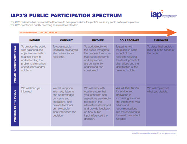
Click here to see a text description.
The IAP2 Federation has developed the Spectrum to help groups define the public's role in any public participation process. The IAP2 Spectrum is quickly becoming an international standard. The table below moves from less impact on the decision in the first column to most impact in the last column.
| -- | Inform | Consult | Involve | Collaborate | Empower |
|---|---|---|---|---|---|
| Public Participation Goal | To provide the public with balanced and objective information to assist them in understanding the problem, alternatives, opportunities and/or solutions. | To obtain public feedback on analysis, alternatives and/or decisions. |
To work directly with the public throughout the process to ensure that public concerns and aspirations are consistently understood and considered. |
To partner with the public in each aspect of the decision including the development of alternatives and the identification of the preferred solution. | To place final decision making in the hands of the public. |
| Promise to the Public | We will keep you informed. | We will keep you informed, listen to and acknowledge concerns and aspirations, and provide feedback on how public input influenced the decision. | We will work with you to ensure that your concerns and aspirations are directly reflected in the alternatives developed and provide feedback on how public input influenced the decision. | We will look to you for advice and innovation in formulating solutions and incorporate your advice and recommendations into the decisions to the maximum extent possible. | We will implement what you decide. |
Public Participation and Geospatial Technologies
Watch this!
The Geospatial Revolution
How can GIS and related geospatial technologies facilitate higher levels of public participation? Let’s approach this question by first watching a six-and-one-half minute excerpt from Episode Two of the Geospatial Revolution series produced by Penn State Public Broadcasting. Early in the video, you’ll hear Jack Dangermond, president of Esri, the GIS software company, state that “geographic information and maps are helping city governments become more democratic and participatory.” Think about that while you watch. Think about which aspect of Portland’s vision of an “interactive city” has the best potential to promote environmental equity.
JACK DANGERMOND, President ESRI: More than half the world's population is now urban. Geographic information and maps are helping city governments become more democratic and participatory.
SAM ADAMS, Mayor Portland OR: Portland has invested in geospatial technologies because it saves us money. It improves our services, our relationship with the people that we're here to serve.
PHILLIP HOLMSTRAND, Portland Corporate GIS Manager: We created Portland Maps to give easy access to citizens for crime data, transportation, property information, where all the pipes are, the utilities, all sorts of information. And we like the fact that the general public can get access to all of the types of data that we see here at the city.
BIBIANA MCHUGH, IT Manager, GIS and Location Based Services, Trimet: Our system is called TransitTracker. We were one of the first in the country to implement computers and GPS on board all of our buses. We've got the centralized database, and all this information and real-time location of the buses is available for everyone through the Internet and our customer service department.
SPEAKER 1: What time were you thinking of?
BIBIANA MCHUGH: Because of that, we're able to build mapping applications that allow better-informed decisions. We can see that the number 15 is due to arrive in nine minutes. We can also turn on 6-inch aerial photography. We also have links to Street View so that people can know what to expect. Let's pull up more detailed information about that stop, for instance, crosswalks, curb cuts, lighting. If someone has a disability, knowing there's a crosswalk or a curb cut there is very important.
Some of the applications provide real-time information out in the street. This application is called PDX Bus. And right now it's using GPS and our services to tell you that the eastbound MAX, it's arriving right now.
SPEAKER 2: Because of CivicApps for Greater Portland--
PHILLIP HOLMSTRAND: Our mayor challenged us to create a way for mobile users to catalog issues around Portland. PDX Reporter is an app that anyone can install on their mobile phone. We have some graffiti. You can take a photo of it and send it in with the GPS coordinates.
SAM ADAMS: Suddenly I had tens of thousands of eyes and ears because of PDX Reporter. And it gives us good feedback in real time that's geographically coded, and therefore useful for us to follow up on.
PHILLIP HOLMSTRAND: As soon as I submit the report, I'm actually able to get back a detailed status of where this incident is at in the city's system.
GARY ODENTHAL, Technical Services Manager: The Bureau of Planning & Sustainability does long-range planning to inform future development or redevelopment. What do we want the city to look like in 25 to 50 years? There's an awful lot of analysis.
You have to address economic development. You have to address housing. And you have to address environmental issues, et cetera. We couldn't do any of this without GIS. For the first time, we have the 3D building model for the whole city. And that's possible because the whole region now has LIDAR data.
KASS GREEN, President, KGA Geospatial: With LIDAR systems, the satellite or aircraft beams down to the Earth. The beam bounces back up. They gather information based on the return of objects on the ground. So you end up with a very good terrain model.
PHILLIP HOLMSTRAND: At laser-point accuracy, literally, we can take our information and actually start to visualize things three dimensionally.
GARY ODENTHAL: Instead of worrying about what if a proposed building threw a shadow all over the park, we did a shadow analysis using the GIS to calculate that it doesn't really impact the park. People went out and measured it, and we were within two feet, I believe.
The city says you can't build anything that's going to block the view of the mountain from up on the hills. With the GIS, we're able to do site-line evaluation to prove that proposed buildings would not block the view of the mountain. And that made people happy.
The city has set a goal that 90% of all Portlanders will live within walking distance of most of the things they need by 2025, and it's really resonated with the public. So we did a statistical analysis of the areas that are not 20-minute neighborhoods. They don't have any sidewalks, or the terrain is too steep, or there's no transit here, or there's no grocery store. So there's all sorts of things that we can answer now because we can overlay all of this data one on top of the other.
SAM ADAMS: I think our investments improve the way that we perform our work as a city government. It just makes good business sense.
CommunityViz
In this class, you’re using a software product called ArcGIS to work through a route suitability analysis for an electric transmission line. Some professional planners use a software extension to ArcGIS called CommunityViz to help facilitate public participation in land-use planning and other public policy decisions. Take a look at a couple of brief demos of CommunityViz. While you’re watching, think about how this product extends the capabilities of the ArcGIS software you’re learning to use. Watch closely; you’ll be quizzed about these demos at the end of the lesson.
Case Studies of Public Participation GIS
Reading Assignment
Now that you’re familiar with CommunityViz, please read a couple of brief (two pages each) case studies describing how it’s been used. In each of these cases, think about levels of participation, and the ways geospatial technology is used to facilitate public engagement. Read carefully please!
- Case Study 1: Placeways, LLC (2010) "Sustainable Energy Strategy for 'Future Cities'." Arnhem, Netherlands—A MapTable with CommunityViz deployed for "Arnhem CO2 Neutral.’ Accessed April 16, 2011 at http://communityviz.city-explained.com/PDFs/casestudies/Arnhem.pdf [17]
- Case Study 2:: Placeways, LLC (2010) Comprehensive Highway Corridor Study, Lancaster County, South Carolina—Land Use, Transportation, and Economic Development in a High Growth Area. Accessed April 16, 2011 at http://communityviz.city-explained.com/PDFs/casestudies/Lancaster.pdf [18]
The Limits of GIS as a Means to Build Consensus
Reading assignment
Read pages 3-14 of Chapter 9, [19]“Integrating Geographic Data,” in the open textbook Nature of Geographic Information [20]. This should only take 10-15 minutes. (You can ignore the “Try This!” activities that are meant for a different class.) Chapter 9 describes how GIS was used in attempts to identify suitable and acceptable sites for low level radioactive waste (LLRW) storage facilities in Pennsylvania and New York.Here are some of the things you should know and be able to do after reading the chapter:
- Discuss the difference between raster and vector approaches to GIS-based site suitability assessments.
- Describe how a GIS “buffer” operation might be used in a site suitability analysis.
- Explain why the GIS approach failed to win the public’s confidence.
Test Your Knowledge
Activity
Note
This activity contains two parts - See the course calendar for specific due dates and time frames:
- DUE SUNDAY: Complete a quiz on the contents of this lesson.
- MONDAY THROUGH SUNDAY: Participate daily in a class discussion.
Because we will be using an online discussion forum that is asynchronous for this activity, you will need to begin work right away! Be sure to log in to the class discussion forum multiple times between Thursday and Sunday so that you can keep the discussion going.
Directions - Part 1, Quiz
Take the "Lesson 4 - Facilitating Public Participation with GIS" quiz. The quiz consists of 10 multiple choice and short essay questions. You may only take this quiz once, but you may use your notes. This quiz will only be available until the due date indicated on the calendar. Be sure to complete it on time! THIS QUIZ IS NOT GRADED.
Directions - Part 2, Discussion
- Select the "Lesson 4 - Discussion" forum from the Lesson 4 module and discuss the following. Your peers in this class come from varied backgrounds and locations. Given this, what specific incidences of environmental justice impacts your home location. Be specific about the type, location and population impacted and what has been accomplished to correct the situation. You can use the EPA's EJ [21]SCREEN [22] to assist you.
- Read the postings made by the other GEOG 469 students.
- Respond to at least one other posting by asking for clarification, asking a follow-up question, expanding on what has already been said, etc. Make sure your posting is meaningful! I do not want to see "I agree" type postings! Your responses should add value to the discussion.
- Return to the discussion forum daily to read new postings, answer questions directed specifically to you, and to respond to any other postings of interest with your own questions or thoughts!
Grading Criteria
I will not be recording your quiz grade. I will, however, be reviewing your quiz submission carefully and including your responses in the summary for the whole class.
All students are expected to participate in the questions in their group discussions in a concise, well-organized, and scholarly manner. Saying, “I agree with Jennifer” is not adequate. You need to say why you agree (or disagree) and support your comments. Comments should be based upon information obtained from appropriate reference sources including lesson materials, previous coursework, Web-based information, or personal experience. You must use proper grammar and spelling for all contributions.
Your contributions to this assignment will be graded on a 15-point scale. Look at the discussion rubric [23] for more details about my expectations.
Summary and Final Tasks
Wise decision makers welcome public participation because it can lead to better decisions. In this lesson, you've learned that there is a spectrum of participation, from merely informing the public to more meaningful involvement, collaboration, and empowerment. The right level of participation depends on the circumstances, but, too often, the public isn't involved enough in decisions like the ones discussed in this course. This week, you read case studies that demonstrate how, under the right conditions, GIS and related geospatial technologies can facilitate higher levels of public participation. Keep in mind, however, that technical solutions alone are not enough to overcome concerns about environmental justice.
Reminder - Complete all of the lesson tasks!
You have finished Lesson 4. Double-check the list of requirements on the first page of this lesson to make sure you have completed all of the activities listed there before beginning the next lesson.
Tell us about it!
If you have anything you'd like to comment on, or add to, the lesson materials, feel free to post your thoughts in the Questions? Discussion Forum.