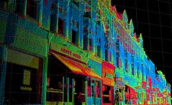
One of the hottest topics in the lidar industry at present is mobile mapping: dynamic terrestrial lidar, often combined with simultaneous oblique, stereo image capture. Collection of very high resolution, high accuracy street-level views of urban infrastructure is facilitated by GPS/IMU on a moving platform, capturing vast quantities of GIS-compatible lidar point cloud data in a relatively short amount of time. A terrestrial lidar system is able to see between buildings and under tree canopy in ways that airborne lidar, regardless of point density, will never be able to. Mobile mapping systems generally collect a full 360-degree field of view at a speed of 15-20 miles per hour. This highly precise data can be used to create realistic streetscapes and highly accurate road maps for vehicle navigation.
The direct georeferencing component of mobile mapping is similar in concept to airborne platforms, but distinct in practice. It is virtually impossible to maintain GPS lock throughout an entire mobile survey. The system must be able to travel, and accurately map, beneath tree canopy, under bridges, and in urban canyons without loss of positional accuracy. The IMU system and Kalman filtering algorithms become critically important; the airborne requirements for GPS/IMU quality simply do not apply in these conditions.
As with every application discussed so far, ancillary imagery and significant data post-processing is often key to producing GIS or CAD-compatible final products. For most end user applications, a very dense cloud of lidar point is not particularly helpful. Most applications require solid surfaces with clearly defined edges, and topologically-structured feature entities (points, lines, and polygons) with comprehensive attribution. The time and effort involved in extracting these features from lidar point clouds has been stressed in earlier lessons. The need for special software and custom data formats described for static systems carries over to mobile systems and is amplified by the sheer quantity and complexity of the data acquired.
Browsing the technical program for any major lidar industry meeting will clearly demonstrate the keen interest in lidar-centric, mobile mapping systems. Integration of mobile mapping data (yielding detailed roadways and urban infrastructure) with airborne topographic lidar terrain models and oblique optical imagery is sure to become the gold standard for 3D navigation and visualization in the very near future.