A. Instructions - Download the image files
In the text that follows there are specific references to the image files used in the project.
The data for the project consist of these image files: (1) a USGS DRG, and (2) a USGS DOQQ of the area in question, and (3) images of Sanborn fire insurance maps.
To aid you in understanding the abbreviations, codes and symbols used on the Sanborn maps you will also be provided with the following files: sanbornKeyColor.jpg, sanbornAbbreviationsLegend.pdf, sanbornShortKey.jpg
B. Part 1 (Week 1): Preliminary Assessment and Database Design
- For this portion of the project you will answer some questions that will help organize your thinking, and demonstrate your readiness to begin creating the project datasets.
- You will also design and implement a Personal Geodatabase for the project.
NOTE: Your assigned Sanborn map is map 2B (1920_02B.jpg in the Sanborn folder).
- Examine the 1920 source maps you will be digitizing, located in your [Unzip Path]\MGIS\G484\EXAM\Sanborn directory.
If you want to read more about the Sanborn Map, visit If you want to read more about the Sanborn Map, visit Wikipedia's Sandborn Map article (http://en.wikipedia.org/wiki/Sanborn_Maps) or The Geography and Map Reading Room (http://www.loc.gov/rr/geogmap/sanborn/san6.html) - Evaluate the aerial photo (the DOQQ.jpg file) and DRG (the o38078a4.tif file) of the city provided in the EXAM directory.
The aerial photo is an orthorectified photo (a DOQQ), in UTM Zone 17 North, NAD83 coordinates.
But, what happens when you bring it into a new, empty ArcMap session?
You must remedy this situation before you can proceed with the project, because you will be using the aerial photo as the basis for georeferencing the Sanborn maps. - Review the following list. It contains hints, and some specific instructions, for designing a database that will meet the three ACHS requirements listed in the Background section, above:
- Subjectively place buildings into one of three land use (or "building use") categories: (1) residential (homes), (2) commercial (businesses), or (3) public (churches, government buildings, etc.). You will be digitizing from the maps for 1920. The ACHS envisions having layers that depict the city in 10-year intervals (1900, 1910, 1920, etc., through 1990).
- To locate many addresses quickly, it is useful to have a street centerline layer that is set up with the proper fields to allow geocoding to be performed via a geocoding service. You should refer back to the geocoding lesson in GEOG 483 (Lesson 4, particularly the figure in the Concept Gallery).
Also, go to the ArcGIS Desktop Help:
Search tab | Commonly used address locator styles in the ...search for slot. Model your feature class on the US Streets system, incorporating fields to hold the street name information: prefix (or suffix), name, type. - Street address numbers are shown on the Sanborn maps for most buildings. These addresses, recorded at the building level, can be useful in situations where it is desirable to pinpoint addresses to a higher degree of accuracy than allowed by geocoding services using interpolation.
- Recording the number of stories of each building will enable future viewing of the city in 3-D. If the number of stories is not shown on the Sanborn map, you may assume that the structure is 1 story in height. Or, if the height in feet is given, convert it to stories.
- The ACHS is not interested in the fire-related information like construction material, entry-ways, sprinklers, etc. You do not need to include this data in your database.
- The Albemarle Charlottesville Historical Society wants the data to be stored in a geodatabase, in an appropriate Cartesian coordinate system / map projection. They also want the data to be in a form that can be used by people working in open-source software environments. This means that the final feature class layers will need to be duplicated as Shapefile datasets, and to be most "flexible" the shapefile versions should be in Geographic Coordinates (degrees of longitude and latitude).
Part 1 Instructions
- Use the above hints and instructions to answer the questions that follow. Thinking through these questions will help when designing the database, and will prepare you for the georeferencing that takes place in Part 2.
Questions:
- What vector spatial data layers will be needed in order to generate the desired end product? What feature types (point, line, or polygon) should be used to represent the features on those layers? Briefly explain why you need each vector spatial data layer. If you decide your database needs any separate tables, also justify their need.
- What attributes should be associated with your features and how should the attributes be defined (Long Integer, Double, Text, etc)? Explain the need for each field.
- How will you associate a designation of the time period, 1920, with the feature classes you create? Be mindful of the integrity of your data versus considerations of data-redundancy.
Justify your decision. - What do you need to do in order for the image file of the orthophoto (the DOQQ.jpg file) to be properly prepared for the project? Be specific as to tool or technique.
- I alluded above to the fact that you will georeference the Sanborn maps based on the orthophoto. Why not use the DRG (the o38078a4.tif file) instead?
- I want you to use the affine transformation when you georeference the Sanborn map image. The software allows you to create a world file during the georeferencing process. Explain how this is done, and explain the contents of this file. Differentiate creating a rectified image from simply creating only a world file.
- When georeferencing the Sanborn map image files, will the RMS Error reported by the software be of any more diagnostic value than your visual assessment of how well the Sanborn map aligns with the orthophoto?
Explain. - What specific steps will you take to create shapefile datasets from your final feature classes? Remember, they have to be in Geographic (lon-lat) coordinates. In other words, what specific ArcGIS tools or commands will you use?
- Based on the hints and instructions in step 4, above, and on the answers to the questions in the preceding step, design a database structure that will satisfy the ACHS requirements. This must be a Personal Geodatabase.
- Implement your database design within ArcCatalog. At this point the geodatabase will contain no actual data. (When it comes to actually inputting the data (in Part 3), you may discover that your database design needs some modification.)
Deliverables for Part 1
- Submit the following deliverables to me via email. These are worth 25% of your score.
- The answers to the questions. Please submit these answers in a Microsoft Word document.
- Your Personal Geodatabase that you have created in preparation for the digitizing portion of the project.
C. Part 2 (Week 2): Prepare to Digitize Vector Data
- For this portion of the project you will georeference your assigned Sanborn map image file (1920_02B.jpg in the Sanborn file).
- You will compile a concise list of steps describing the georeferencing process.
- You will premeditate any special digitizing considerations.
At the end of this document there are important tips that should help you in georeferencing the Sanborn maps.
- Georeference the Sanborn map that was assigned to you, keeping detailed track of the steps necessary. Employ the affine transformation, and be certain to create a world file.
- Keep track of the time you spend on the georeferencing, for the sake of the time estimate that is part of the Part 4 final report.
- Several of the buildings on the Sanborn maps share walls (multiple uses in a single building), and the street centerline layer is intended for use with a geocoding service. In each case what special digitizing settings/considerations must be used/taken into account?
Deliverables for Part 2
- Draft a single workflow document, of sorts, that includes the following:
- A detailed list of the steps necessary to georeference a Sanborn map. Compose this as though it were instructions for a summer intern -- in essence, a tutorial.
- An estimate of the time needed to perform the georeferencing.
- A summary of special digitizing settings/considerations for each of the feature classes
- The world file that you created in the process of georeferencing.
- Submit the following deliverables to me via e-mail. These are worth 25% of your score.
- Your workflow document. Submit these answers in a Microsoft Word document.
- The world file that you created during the georeferencing process.
Do not proceed with Part 3 until your workflow and world file have been approved.
D. Part 3 (Week 3): Populate your Geodatabase
- In this portion of the project you will populate your feature classes with data, paying attention to data integrity.
- You will combine your feature classes with adjacent data that I supply after you finish the work in Week 1, Part 1.
- You will create shapefile versions of your feature classes.
- If you had any problems georeferencing your assigned Sanborn map, be certain they have been solved.
- Document your methods of preventing data entry errors.
- Populate your feature classes by digitizing the necessary features and by adding the required attributes.
To help with the attribute information, take advantage of the map legend and abbrviations files you were provided. - Keep track of the time you spend on the data entry, for the sake of the time estimate that is part of the Part 4 final report.
- Document any unforeseen things you run into while digitizing--things not accounted for during the database design stage, etc.
- Verify the spatial and non-spatial integrity of your data. Correct any errors you find. Document your methods.
- Combine your feature classes and the adjacent data from Sanborn map 2A into single feature classes.
- Convert each combined feature class into a shapefile dataset. Be certain each shapefile dataset is in the coordinate system specified by the Historical Society (lon-lat).).
Deliverables for Part 3
Submit the following deliverables to me via e-mail. These are worth 25% of your score.
- Your personal geodatabase containing the digitized and attributed features of interest for the maps assigned to you, combined with the supplied adjacent spatial data.
- Shapefile versions, in Geographic coordinates (lon-lat), of your combined feature classes. Bundle the shapefile datasets into a .zip file.
- A Word document outlining: (1) preventing data entry error, (2) unforeseen challenges to your database design, and (3) data integrity checking and correction.
E. Part 4 (Week 4): Create a Final Report
- In this last portion of the project you will create a final project report!
- Your final report should demonstrate your understanding of the techniques and concepts used in this project.
The final report should contain:
- a brief description of the database design. Assume your audience is BOTH the Albemarle Charlottesville Historical Society and me. For the sake of the Historical Society include a brief description of the data contained in the geodatabase. Then explain what types of analysis and display those data will make possible, and what sorts of things may not be possible.
For my sake describe what, if any, modifications or improvements you might consider making to the database. - an estimate, for the sake of the fictitious bid, of the level of effort (total hours) required to georeference and digitize the Sanborn maps for the entire project (from Weeks 2 and 3).
Recall that the ACHS envisions having layers that depict the city in 10-year intervals (1900, 1910, 1920, etc., through 1990). There are 30 maps for the 1920 period alone. Assume there are the same number of Sanborn maps for all intervals (which, unfortunately, is not the case). - an analysis/discussion of the level of error for the database: (NOTE This is distinct from the work you submitted in Week 3 having to do with preventing and correcting data input errors.) What are the sources of possible error when it comes to the spatial and attribute data? Is the error acceptable given the purpose of the project? Keep in mind that your prototype study was based on only a subset of the maps for a single time period.
- illustration that the database will satisfy future mapping needs by creating thematic maps that illustrate various aspects of the data contained in your data base. A plan view (2D) land use (building use) map, and a plan view (2D) building height map are obvious choices. [If you have access to ArcScene (part of 3D Analyst) it can be used to create a height map in 3D.] Create a minimum of 2 different thematic maps.
- The final report must be accompanied by a metadata document for at least one of your feature classes or shapefiles (not for stand-alone tables).
Choose a metadata style other than "Item Description," and use the metadata editing tools in ArcCatalog to fill out:
- the basic Overview | Item Description fields (Summary, Description, etc.), as well as
- the Resource | Extents | Description field, and
- the Resource | Fields | definition of each user-created field in the attribute table.
Fill out any other fields you deem pertinent.
Since you are not resubmitting your geodatabase or Shapefile datasets, you will need to provide your metadata to me some other way. You can do so in a number of ways. The Export option can be problematic, so I recommend one of three Print options: (1) from the Select Printer list under the Print tab, choose Microsoft XPS Document Writer, (2) from the Select Printer list under the Print tab, choose the PDF choice (one will be there if you have an application installed that allows creation of PDF files), or (3) simply expand all sections of the metadata, click-drag to highlight it (or use Ctrl-a), and then Copy-Paste the information into a Word document
Deliverables for Part 4
Submit the following deliverables to me via e-mail. These are worth 25% of your score.
- A Word document containing components 1-4 of the list above.
- The metadata printout (#5 above).
This completes the GEOG 484 mastery project.
Appendix A - Georeferencing Tips
- Rotate the Sanborn map jpeg in order to align the streets with those on the photo (approximately 15 degrees). (Use the Rotate tool found on the Georeferencing toolbar. DO NOT USE the Data Frame toolbar!)
- Make the Sanborn map jpeg approximately 40% transparent.
- Zoom to approximately 1:2000 scale.
- Use the DRG to orient yourself.
- Use the orthophoto when placing control points.
- Use the Magnifier window at ~200%.
- After placing a control point on the Sanborn map jpeg, remember that you can turn off the jpeg to get a better view of the photo.
- Try to use street corners in the photo not covered by shadows.
The map below shows the central part of the city (in the southwest corner of the DRG) and provides street labels corresponding to the streets labeled on the Sanborn map jpegs. Below the map are 3-4 suggested control point locations for each Sanborn map. Feel free to use additional or different locations to georeference the Sanborn maps.
Note that the city is divided into quadrants (NW, NE, SE, SW) whose origin point is the 1st & Main intersection. This is important because the numbered streets repeat. You should notice that on the map below that there are two 2nd Streets. The western one is in the NW and SW quadrants of the city; the eastern one is in the NE and SE quadrants. If you are working with map 2a, you will have 2nd Street NW on your map; if you are working with map 3a, you will have 2nd Street NE on your map.
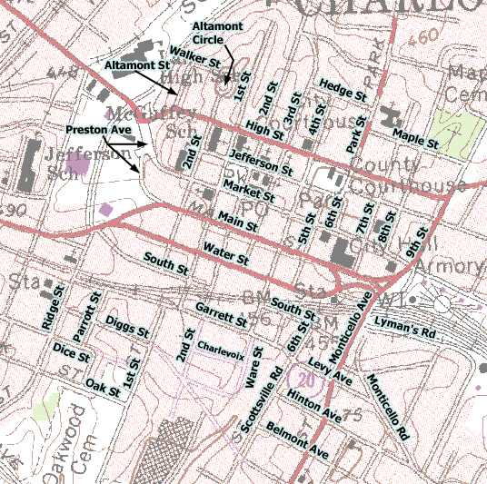
| Map 2a | Map 2b | Map 3a | Map 3b |
|---|---|---|---|
| Jefferson/1st | Main/1st | Jefferson/1st | Main/1st |
| Main/1st | South/1st | Jefferson/4th | Main/5th |
| Market/2nd | Water/2nd | Main/5th | Water/5th |
| McGuffey School | Main/South | Main/1st | South/1st |
Appendix B - Getting Started with ArcScene
Following are some instructions that will allow you to render your building footprint layer in 3D. I encourage you to explore ArcScene beyond the few steps provided here. There are several entries in the Help that have to do with ArcScene, too.
If you installed the 3D Analyst Extension when you installed your ArcGIS software, you should have access to ArcScene.
Open ArcScene by going to Start | All Programs list | ArcGIS | ArcScene.
A. Extrude Polygon Features
The ArcScene interface is similar to ArcMAP. You can add spatial data layers and attribute tables to the table of contents pane, and perform attribute Joins, etc., just as you can in ArcMap.
- Add your building footprint feature class to the ArcScene document. You will want to be able to access the height and building use attribute data. Depending upon your database design you may need to add additional attribute tables that contain the desired information.
Perform any Join operations that might be necessary. - Right-click on the footprint layer name and open the Layer Properties dialog.
- Click the Extrusion tab.
- Click on the calculator icon found to the right of the Extrusion value or expression: window to open the Expression Builder dialog window
- In the Expression window build and expression that incorporates the field that holds the building height information. The expression can be as simple as the name of field. However, you are apt to want to vertically exaggerate the extruded building height by multiplying the field by some arbitrary factor.
When you build your expression the Extrude features in layer. ... check box should become checked. Make sure it is. - Click OK to dismiss the Expression Builder window
- Click the Apply button in the Layer Properties dialog. This will leave the dialog window open but show the results of your extrusion.
You could add your street centerline layer, too, if you desire.
B. Symbolize Based on the Building Use Information
A multivariate thematic map shows more than one set of data. Currently only your height data is being displayed. Let's also make it so that the map shows the building use data.
- In the Layer Properties dialog, click the Symbology tab.
- Use the Categories method to symbolize the building shapes by colors that represent each category of building use. You should know how to interact with this part of the Symbology dialog from your past experience.
C. Modifying the Perspective of the View
There are several tools in the icon tool bar at the top of the interface. The Navigate tool and the Pan tool allow you to alter the perspective of the 3D view. The effect of the Pan tool is subtle.
- Find and select the Navigate tool icon. It looks like a small globe with black arrow heads on four side.
- Place your mouse cursor in the data frame area and click-hold as move the mouse. The perspective of the view will alter.
D. Export the Map Image
- To export an image file of the map, go to File menu | Export Scene | select 2D | choose an image format (JPEG, etc.)
- In the Save in: slot, navigate to where you want to store the output image file and click Save.
ArcScene does not have anything comparable to the Layout View of ArcMap. It is also not possible to easily label features in the scene. So, be sure to include a good caption with any 3D map that you include in your deliverables. If you want, you can Export a JPEG image file, for example, then add it to an ArcMap session, and use the Layout tools at your disposal there to add a title, etc.