Defining Environmental Geospatial Technology
Environmental geospatial technology applications typically manage a physical system involving its land, water, air, and biota. An interesting question to ask is, “for whom are we managing this environment?” We can divide environmental applications of geospatial technology and data into two broad categories within this line of inquiry: 1) managing the environment to protect ecosystem services that humans rely on, and 2) managing the environment for its own sake and protecting the wildlife that lives there.
One way to distinguish these two scenarios is by using the labels conservation and preservation. Conservation is the management of natural resources that we, humans, use so that they are available today and will be available to us in the future. These ecosystem services include managing the environment to protect sources of clean drinking water, vegetation that prevents erosion and filters the air, landscapes that have healthy soil that will continue to support agriculture and food production, and bolstering insect populations, like bees, which are required to sustain plants and food we eat. On the other hand, preservation is the management of habitats and natural areas so that they are unmolested by human activity and allowed to operate according to their natural processes and support wildlife for its own sake. In many cases, it may appear that we are protecting the environment for its own sake when, in fact, we are protecting the ecosystem services that benefit humans. This begs the question of whether all of our management activities target ecosystem services.
The Millennium Ecosystem Assessment (2005) defines ecosystem services this way and illustrates the four categories in Figure 1:
Ecosystem services are the benefits people obtain from ecosystems. These include provisioning services such as food, water, timber, and fiber; regulating services that affect climate, floods, disease, wastes, and water quality; cultural services that provide recreational, aesthetic, and spiritual benefits; and supporting services such as soil formation, photosynthesis, and nutrient cycling. The human species, while buffered against environmental changes by culture and technology, is fundamentally dependent on the flow of ecosystem services.
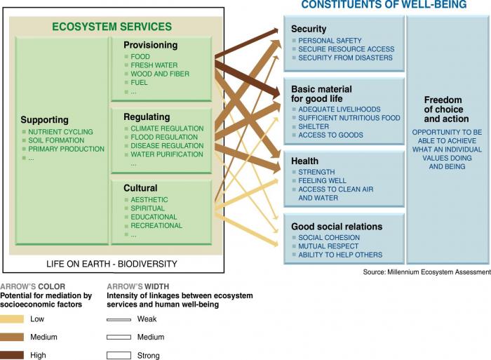
Graphic from millennium ecosystem assessment showing ecosystem services and constituents of well-being. Arrows point from different sections of the ecosystem services to the constituents of well-being. The arrows’ color and width indicate the potential for mediation by socioeconomic factors and the intensity of linkages between ecosystem services and human well-being.
Ecosystem Services
Supporting: nutrient cycling, soil formation, primary production
Provisioning: food, fresh water, wood and fiber, fuel
Regulating: climate, flood, and disease regulation, water purification
Cultural: Aesthetic, spiritual, educational, recreational
Constituents of well-being
Freedom of choice and action: opportunity to be able to achieve what an individual values doing and being
Security: personal safety, secure resource access, security from disasters
Basic material for a good life: Adequate livelihoods, sufficient nutritious food, shelter, access to goods
Health: strength, feeling well, access to clean air and water
Good Social Relations: social cohesion, mutual respect, ability to help others
| Arrow Start | Arrow End | Potential for Mediation | Linkage Intensity |
|---|---|---|---|
|
Provisioning |
Security |
High |
Medium |
|
Provisioning |
Basic Material |
High |
Strong |
|
Provisioning |
Health |
Medium |
Strong |
|
Provisioning |
Social Relations |
Low |
Weak |
|
Regulating |
Security |
Medium |
Strong |
|
Regulating |
Basic Material |
Medium |
Strong |
|
Regulating |
Health |
Medium |
Strong |
|
Regulating |
Social Relations |
Low |
Weak |
|
Cultural |
Security |
Medium |
Weak |
|
Cultural |
Basic Material |
Low |
Weak |
|
Cultural |
Health |
Low |
Medium |
|
Cultural |
Social Relations |
Low |
Medium |
There is some overlap between the conservation and preservation approaches to environmental management, but it’s useful to be cognizant of this distinction when performing analyses so we have a clear understanding of our end goal and what our results are intended to inform.
Let’s narrow our focus on environmental management from the broad concepts of conservation and preservation and contemplate some specific themes to which GIS and geospatial technology could be applied. Some that come to mind are:
- Health
- Pollution (land, water, air)
- Waste Management (human, animal, garbage, chemical)
- Construction Impacts
- Land use impacts
- Habitat management
I see these application areas as likely use cases for geospatial technology within an environmental context. These themes overlap with many disciplines like medicine, engineering, biology, and chemistry, which makes defining “environmental” challenging. There are environmental aspects to all of these themes, and geospatial technology is well-suited to many of them. So, what is it about these themes that make them well-suited to use geospatial technology? How are we using geospatial technology in these contexts that are unique relative to other geospatial applications? Ultimately, how can we evaluate environmental challenges in spatial data science?”
To help answer these questions, this course presents environmental challenges and engages analysis and evaluation methods with projects that are more representative of what you might encounter in the field as an environmental analyst of some sort. As I think about the question of what 'environmental' is, I break it down into a few categories that can be useful in defining it. Consider the characteristics of each of the following prompts in the context of environmental applications:
- What are typical scenarios or application areas to which geospatial technology is applied?
- What types of spatial data are commonly used?
- What types of analysis functions are utilized?
- What is the audience of the analysis output?
- What are the challenges and implications of communicating results?
I can imagine instances where environmental applications of geospatial technology stand apart from other projects in each of these categories. An outcome of Lesson 1 is to identify how environmental geospatial applications are unique by digesting some background material and having a discussion about it. In the next section, we will investigate three particular use cases of environmental geospatial applications to help frame our discussion.
References
Millennium Ecosystem Assessment, 2005. Ecosystems and Human Well-being: Synthesis. Island Press, Washington, DC.
UN Environment (2019). Global Environment Outlook – GEO-6: Healthy Planet, Healthy People. Nairobi, Kenya. University Printing House, Cambridge, United Kingdom.