Orientation
Welcome
WELCOME TO GEOGRAPHY 488 & Software Download: Acquiring and Integrating Geospatial Data
Welcome to Geography 488. Over the next ten weeks you will encounter 9 lessons and one final project. Lessons are largely module based. These modules combine to provide much of the content of the final project. The final project is a problem based learning, self directed, project. You should already know your fellow classmates to some extent. This usually means that there is less activity on the discussion forums than there was in the early classes. I really encourage message board discussions and there is a required discussion forum component each week. Please don't hesitate to ask questions. I am happy to answer private e-mails, but prefer class discussions in which everyone participates in problem solving.
Acquiring and Integrating Geospatial Data is a daunting course title. The topic is very broad and any number of things could be covered. As you can see in the syllabus, a lot of topics will be covered in this course, but certainly not all of the things associated with identifying, collecting, creating, and using geospatial data. One of the first steps in the design of a GIS or of any project or program should be a user needs analysis. This is where the needs are assessed in terms of the final product. This does not mean that the same methods as the existing system need to be adopted, just that the end product should fulfill the needs that have been identified. Therefore we will take the same approach for this class.
Course Format
In this program, you are our client. We have not done individual needs analyses with everyone, but we have input from you and from other professionals in the industry and have a sense of the existing needs, which we hope closely match what you are looking to get out of the program. What is it that you need? What things have already been checked off the list as a result of taking the prerequisites to this course? You've had a great introduction into the fundamental concepts of geographic information systems and science. You've had a fair amount of exposure to a number of elements of GIS and have had experience with processes and operations within a software system. There are sure to be many things left.
In this course we'll cover such things as data needs assessment, metadata content standards, legal and ethical issues related to data use, data formats and types, data conversion, interoperability, field collection methods, and contributing data for public use. Those who successfully complete the course will be able to "spec out" a GIS project, identify appropriate and cost-effective data sources, create data dictionaries, assess and ensure data quality, determine appropriate data formats given an intended data use, transform data from one format to another and understand GIS software functionality related to data conversion. This course generally follows the processing of data as identified by Safe Software: Define, Evaluate, Extract, Transform, and finally Load the data.
We will only briefly cover the needs assessment. The modules and projects are designed to be highly individualized and I hope that you will feel empowered to contribute your own knowledge, experience, and data.
This course is a little different from earlier courses as it is problem based with you learning through the process. The courses you've taken in the program until now have been highly structured. This course will rely mainly on input from you. Class discussions and a cumulative document or e-portfolio will be fueled by the information you collect. There will also be a larger reading and writing component in this class than the ones leading up to it. I don't need to tell you that good writing and communication skills are an integral part of the profession. In addition to the course project, there is a course paper. This is a fairly low stakes paper of only 1000 - 1200 words, but it is a way for you to share your knowledge or research while demonstrating your writing skills. We expect quality work - nothing less than an instructor teaching an English class on campus would expect. No busy work will be assigned. When possible, assignments will be focused around your areas of expertise, as related to the course. Everyone in the course, including me, should benefit from course submissions.
Problem Based Learning
This course is a little different in that it follows a "Problem Based Learning" approach. You may wish to visit the Wikipedia site for more information about Problem Based Learning [1]. Throughout this course, you will be working toward one final course project deliverable. There will be benchmarks along the way to measure progress, but each week you will focus on that final product. The culminating project will be a GIS plan or conceptual design for your local area - "your story". This plan will vary greatly for each of you. Some of you may live in areas where GIS is very mature, while others may live somewhere that has not started a GIS effort. You will go through the whole spectrum of tasks related to creating a GIS plan, from assessing the current situation, to acquiring data that already exist, to integrating data from various sources, to creating some of your own data, and finally to publishing data so that others have access to them.
Syllabus
I invite you to take a look at the course syllabus. Is there anything that you would like to see covered that isn't? Please feel free to post suggestions to the discussion forums. Because this class does cover such a broad range of topics, it is possible, even likely, that you will have experience with one or more of the topics. I do not claim to be an expert in any of these subject areas. My role in this course is to gather relevant information to share with you, facilitate discussions, and provide guidance. Your insights and input can be incorporated back into the projects and can benefit those in successive offerings of the course. It is my hope that the development of this course will never end. I like to take advantage of the Web as a medium and I have the luxury of being able to update course content daily. Please help me make this course a worthwhile experience for everyone in it.
Let's now take a look at where the course is going over the next ten weeks.
Software
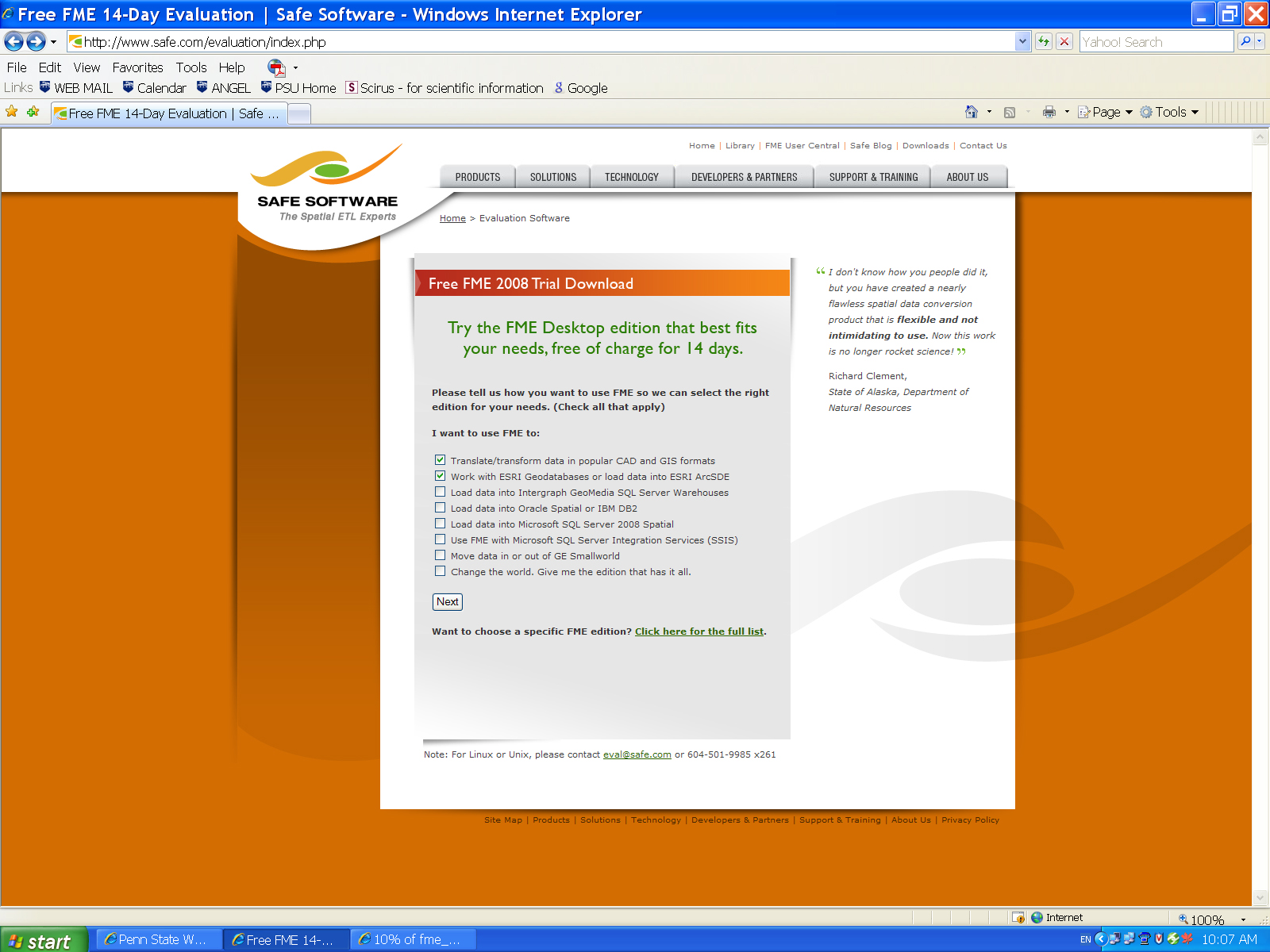
Besides the usual ArcGIS software we have been using we will also have an introduction into Safe Software's Feature Manipulation Engine, here is a link to Safe [2]. Please review the software requirements and down load the software and apply for your time restricted license.
- FME Instructions: Go to Safe Home Page [3] and download trial copy of FME software
- You now need to apply for the 70 day license from the Instructor not Safe.
- Open the download Page Safe Evaluation [4]
- Check boxes for:
Translate/transform data in popular CAD and GIS formats and Work with ESRI Geodatabases or load data into ESRI ArcSDE . Click here for an example. [5] - Download Program and install
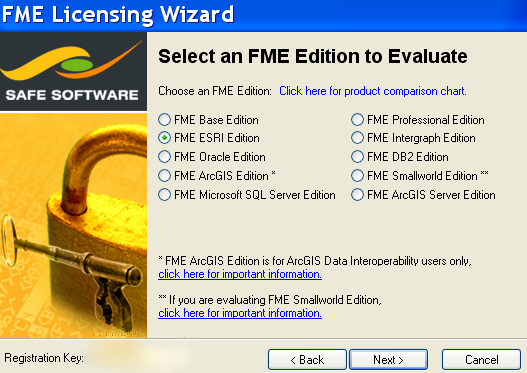
- Make sure you select the ESRI FME edition not the ESRI ArcGIS edition
- Click here for an example. [6]
- Download the file and install it.
- Close the pop-up window licensing window.
- To obtain a Training License for 70 days send me the 10 Digit Registration Key from the lower left side of the program registration window.
- Do not apply for the license from Safe I will send you the license
- I will send you the program registration file as soon you receive it place it in the Safe Installation Folder called Licensing.
- Start using the software, remember this lasts only 70 days before it times out and it is restricted to one machine.
- Support for the Safe Software FME is through the course instructor not Safe Software or World Campus.
Readings and Data
Many of the readings for the course are available through weblinks through open access. Some readings are reserved through ANGEL and only registered students have access through their ANGEL Login. All propriety example data is restricted to registered students in ANGEL.
Roadmap for the Course
Projects 1,2: Assessing and Defining ![]() Projects 3,4: Evaluating and Acquiring
Projects 3,4: Evaluating and Acquiring ![]() Projects 5/6: Extracting, Integrating, and Transforming
Projects 5/6: Extracting, Integrating, and Transforming![]() Project 7/8: Creating, and Loading
Project 7/8: Creating, and Loading ![]() Project 9/10: Publishing
Project 9/10: Publishing
Assessing and acquiring GIS data can be quite time consuming. I will not ask you to do anything I haven't done myself. I've been working on gathering data for my local area. The way we'll approach this course is for me to tell you "my story" each week and then I'll ask you to tell "your story".
Our Story:
Because we have students from all over the country (and sometimes from other countries) we can use the idea of The National Map as a unifying concept. The National Map is in its earliest stages and there is a wide spectrum of opinions about its goals, worth, and ultimate success. However, we can all use the vision of The National Map to guide us in how we approach our own local situation.
The National Map is a multi-agency, coordinated effort to produce current maps based on the best available digital datasets. These data most often reside at the local level. Therefore, funding and standards flow (theoretically and ideally) from federal agencies to the states and local government agencies, and the data flow back up from local entities to regional, state, and federal groups that will compile The National Map.
Framework data layers provide the foundation for The National Map. Generic data schemas define the framework and help ensure that the best available data will be integrated into The National Map. When agencies at all levels use the same schemas, local data stewards can maintain and deliver current data to state and federal agencies. Data distribution and sharing become much easier. By developing data schemas, there can be interaction across the different tiers of government, and a "National" Map can be constructed.
National Map Layers:
- Reference (map grids and labeled tics)
- Transportation (roads, rails, infrastructure, cartographic features, etc.)
- Cultural (human activity layers)
- Administrative (administrative and legal boundaries)
- Hydrography (water features)
- Hypsography (contours, elevation points, TINS, DEMS, etc.)
- Surface Overlays (land cover, land use, soils, etc.)
- Image Base (orthos, DRGs, historical images, etc.)
- Page Layout Design (map templates)
The story you tell in your project may or may not involve those particular layers, but you can assume that some local data in your area are the best available digital datasets and might be a valuable component of The National Map.
The story I will tell throughout the course is about the local water authority in my area and their progress with GIS. I have assessed (and will continue to assess) where they stand with GIS and what they will do in the future. Many of the local basemap layers are important to the authority and would also be an important contribution to The National Map. I've been out in the community tracking down data, so I can appreciate how challenging it will be. Each week, you will hear my data acquisition and integration story. I have tried to weave the learning objectives of the course into the story I am telling about the local water authority. The course project is not about the quantity of data you collect, but rather about thoughtfulness and resourcefulness.
Questions?
That's it for our course introduction!
If you have any questions now or at any point during this lesson, please feel free to post them to the Course Orientation Discussion Forum. That forum can be accessed at any time by clicking on the Forums link in the Resources menu on the left. Be sure to post to the appropriate lesson forum.)
Now, let's continue on with the Orientation...
Checklist
Each lesson in the course will have a list of "Steps to Complete." This checklist will always appear on the second page of each lesson.
To get started with the course, please follow the required steps below. the Course Orientation is one week in length. Please refer to the Calendar in ANGEL for specific time frames and due dates. You may find it useful to print this page out first so that you can follow along with the directions.
| Step | Activity | Access/Directions |
|---|---|---|
| 1 | Read through Course Orientation. | You are in the Course Orientation online content now. Click on the "Next Page" link to continue reading. |
| 2 | Complete the "Initial Course Survey" to help us learn more about your expectations for this course. | A link to the survey is located in the "Course Orientation" folder under the Lessons tab in ANGEL. |
| 3 | Introduce yourself to your colleagues and post a comment to the communication page. | Go to Page Seven of this Orientation for Activity instructions. |
| 4 | If you haven't already done so, carefully review the course syllabus to learn about the course and its requirements. | The Syllabus is located in the Resources menu in the left sidebar. |
| 5 | Begin the course! | Click on the Lesson 1 link in the Course Outline to begin the course. |
Learning Environments
Course Text and ANGEL
Registered students in the online Penn State courses that use this text need to navigate between several environments in the World Wide Web. These include:
Course Web Site [7]
The course web site consists of lessons, each including pages of text, graphics, and activities. Activities prompt readers to explore selected Web sites, to download data and/or software, or other adventures. Registered students may also be prompted to navigate to ANGEL to take practice and graded quizzes.
ANGEL [8]
Penn State's course management system. In ANGEL, registered students consult course calendars, communicate with instructors and fellow students, submit project reports, receive individual project critiques from instructors, take online quizzes, and check assignment scores and course grades.
Note that a link to ANGEL appears at left in the Resources menu off to the left. In ANGEL, registered students will find links back to the text from corresponding Lesson folders under the Lessons tab.
Try This
Navigate from this page to ANGEL, and back again.

Course Web Site
This course web site is presented in an open source content management system called Drupal (for information about Drupal, visit http://drupal.org/ [10]). One advantage to presenting the text in Drupal is that we can enable registered students to comment and ask questions directly on text pages. Another advantage is that Drupal allows us to publish the text openly, for the benefit of anyone who has access to the Internet, regardless of their ability to pay tuition or buy an expensive printed textbook (this is applicable to certain courses in our program).
Login
Anyone with a Web browser and Internet access can view this text without logging into this Drupal site. Only registered students can log in. To log in, click on the "Log In" link on the left sidebar. Log in with your Penn State Access ID and password.
Start Here
- Orientation - familiarizes registered students with the learning environments used to conduct Penn State courses
Resources
- Course Home Page
- Program Home Page (links out to the Penn State Online Geospatial Education Web site for program information)
- Syllabus (lists out instructor information, course description, and an account of what is expected of each student)
- Instructor Information - contact and other information about your instructor
- ANGEL (links out to ANGEL)
- Library Resources - links out Penn State library resources specific to Geography
- Writing Style Guide - useful resource for writing
- Help (information on how to get help with various aspects of the course)
Course Outline
- Links to lessons
- When you click on a Lesson link, links to the pages that make up the lesson are revealed.
- Navigate between pages using "Next" and "Back" links OR select a page from the Course Outline menu.
- Each lesson includes an overview page, checklist page, multiple content pages, and a summary.
Printing Options
- Note the "printer-friendly" buttons for each page or each entire chapter located in the upper-right corner of the window.
- The printer-friendly versions compile pages or lessons into a single HTML document. You can access this at any time by clicking on one of the two options in the upper right corner of each text page.
Course Management System
Penn State uses an online course management system called ANGEL to deliver most of its online courses. This page will:
- provide a list of recommended browsers and computer configuration guidelines
- explain how ANGEL is organized
- explain how to communicate in ANGEL
- explain how to get help with ANGEL related questions.
ANGEL MAINTENANCE SCHEDULE: ANGEL maintenance is conducted daily between 4:00 and 6:00 a.m. U.S. EST, during which time ANGEL is unavailable. Please do not plan to do any work in ANGEL during this time as it WILL be lost.
Supported Browsers and Computer Configuration
To make sure your computer is configured properly for ANGEL, refer to the "Recommended Browsers and Computers [11]" listing on the ANGEL site. Failure to follow these recommendations may result in significant issues while viewing materials, taking assessments and using dropboxes. You use unsupported browsers at your own risk.
ANGEL Course Interface
- Syllabus - The course syllabus outlines educational objectives, assignments, and grading and other policies.
- Calendar - This is the official record of assignment due dates. By default, the calendar displays one month at a time. "Page forward" using the "Next" link to see the rest of the semester. Hover your mouse pointer over an entry to see the details.
- Lessons - Under the Lessons tab you will find a link to the course web site (which contains a to do list for the week, commentary, activities, etc.) as well as quizzes and drop boxes. There is a separate folder for each lesson of study. When you are ready to begin a lesson, simply click on the course web site link. Once you are in the course web site, you will be directed to either go through the course content and/or to complete certain tasks in ANGEL. Each folder under the Lessons tab will correspond with a specific lesson. The materials inside each lesson folder may include,
- Dropboxes to submit assignments
- Quizzes
- Note: Some lessons do NOT have lesson folders associated with them.
- Resources - Links to useful sites and services, such as Course Announcements and Penn State Library Tools.
- Communicate - A variety of tools are available here, including:
- Course mail: A tool for sending private email to one or more instructors or registered students
- Discussion forums: a kind of "public email" that everyone in the class can view and reply to. You'll find several topical forums under the Communicate tab (as well as under the Lessons tab), including "Personal Introductions" and "ANGEL," as well as chapter- and project- specific forums
- Report - Tools to help students and instructors keep track of students' progress in the course. The handiest tools include:
- Milestones: Keeps track of the assignments posted in the calendar that you have completed
- Gradebook: Quiz scores are automatically posted here. Project scores are manually uploaded by instructors.
- Grades - The Grades tab is where you will find your grades for the class.
If you are new to ANGEL, please review the Quick Guide for Students [12] to acclimate yourself further! Additional how-to resources can be found by clicking on the Help button in the far left of your ANGEL window.
Configure Your ANGEL Account
To get the most out of ANGEL, registered students should configure their ANGEL profiles as follows:
- Update your "Personal Information Settings" for ANGEL to make sure that the rest of us have current information about you.
- Visit the ANGEL Help Guide: Personal Information Page [13] for guidance on how to do this. Fill in the boxes on the resulting page with your current information. Include the URL for your personal web page or blog if you have one.
- Set up your course email preferences. You have the option of forwarding a COPY of your course e-mail to your personal email address. You will NOT be able to reply to class email that way, but it is a way to be notified of email sent to you in the course.
- If you want your mail forwarded, visit the ANGEL Help Guide: Forward ANGEL Mail [14]for guidance on how to do this.
- NOTE to registered students: All official communications from the Penn State World Campus are sent to students' Penn State e-mail accounts. Be sure to check your Penn State account regularly, or forward your Penn State e-mail to your preferred email account, so you don't miss any important information.
- Turn on the "My Announcements" and "New Mail" and "What's New - Discussion Forums" alerts. On your Profile page you have the option of being alerted to any new items that have been added to your courses, including announcements, discussion forum postings, and e-mail messages. We recommend that you turn on the "My Announcements" and "New Mail" alerts so you don't miss anything!
- Visit the ANGEL Help Guide: Course/Group Settings [15] for guidance on how to do this.
Need Help with ANGEL?
The Help link in the Resources menu at left provides links to help registered ANGEL users at Penn State.
Assignments
Registered students earn academic credit at Penn State by completing the following assignments. Opportunities to demonstrate learning include the following, and grades will be based on percentages assigned to each of several components of the course as follows:
Your course grade will be based on a course paper (20 points), your participation in online discussions (10 points), online tests and quizzes (10 points) five class modules (total of 40 points), and a final module (20 points). A total of 100 points are possible. See below for more information about each of these components of the course.
NOTE: Weekly deliverables, that are not in a drop-box, are normally placed in an E-Portfolio. If you want other people to see examples of your work you can use an E-Portfolio. Click here for instructions on "Creating your Web Page (Portfolio). [16]"
However, if your data is propriety or has other security concerns you can send me the required material in an email. Please inform me when you post your material to your portfolio by sending me the updated URL link. This saves me from checking for empty folders.
Course Paper
- 20% of your grade (20/100 points)
You will be expected to write a course paper in this course. The paper is due by week 8. See the Course Paper Assignment [17] page for more information about this assignment.
Online Discussion
- 10% of your grade (10/100 points)
Each week you will be expected to take part in class discussions, most often through threaded discussions on the course discussion forums. I will use the following scoring rubric to determine your Online Discussion grade.
| Exemplary (2 points) | Acceptable (1) | Unsatisfactory (0) | |
|---|---|---|---|
| Participation | Posted insightful comments and questions that prompted on-topic discussion. Helped clarify or synthesize other group members' ideas. If disagreeing with another group members' ideas, the participant stated disagreement or objections clearly, yet politely. | Consistently had to be prompted or coaxed to participate. Usually, but not always, expressed herself or himself clearly. or Posted a late response. | Extremely reluctant to participate, even when prompted. Rarely expressed himself or herself clearly. or Failed to participate. |
Online Quizzes
- 10% of your grade (10/100 points)
Some weeks you will be expected to complete online quizzes.
Class Modules
- 40% of your grade (40/100 points)
Most lessons contain a graded module for you to complete. Most of these weekly module assignments will be draft portions of your final project. There will be a few weeks in which there is a mini module to complete and then post maps or write-ups about the module. Each module involves some aspect of GIS. Modules are designed to be moderately challenging. The key to success is to stay on schedule, follow directions, and ask questions and participate in discussions via the discussion forums. All modules are due within one week of the scheduled beginning of each new module. All of the modules are individual assignments. Weekly deliverables are also described in each lesson.
Class modules are worth the following number of points:
Lesson 2 = 5 points
Lesson 3 = 5 points
Lesson 4 = 10 points
Lesson 5/6 = 10 points
Lesson 7/8 = 10 points
I will use the following scoring rubric when grading class modules. NOTE: Multiply by 0.25 for 5 point assignments (modules 2 and 3) and by 0.5 for 10 point assignments (modules 4, 5/6, and 7/8).
| Exemplary (5* points) | Accomplished (4*) | Developing (3*) | Beginning (2*) | Poor (1*) | |
|---|---|---|---|---|---|
| Content | All criteria of the module are met. It is well balanced, detailed, organized, reflective, and supported by sources. | The author provides a detailed, reflective discussion of his or her experience with the module. | The module lacks balance and/or detail. A discussion of the author's personal experience with the module is provided, but it is relatively brief and not particularly reflective. | The module lacks detail. A discussion of the author's personal experience is very brief and not supported by personal reflections. | The module criteria are not addressed. The author does not express his or her personal perspective, or otherwise fails to complete the module. |
| Clarity | The module is very well-organized. The writing is readable, clear and easy to follow. | Some portions of the module are somewhat unclear and lacking in organization and development. | Some of the module is unclear and/or lacking in organization and/or development. | Much of the module is unclear and/or lacking in organization and/or development. | The module is difficult to read, disorganized, and underdeveloped. |
| Mechanics | Mechanics (spelling, punctuation, grammar, sentence/paragraph construction) are virtually flawless. | There are a few minor errors in format and/or mechanics. | There are major and/or frequent errors in format and/or mechanics. | There are major and frequent errors in format and mechanics. | There are numerous and significant mechanical errors. |
| Presentation | Design is appropriate for a professional portfolio. It is well-organized, includes polished graphics and a color scheme that aids readability, and is easy to navigate. The presenter uses visuals appropriately to underscore key points. | The presentation of the portfolio is professional, including appropriate graphics and colors. | The presentation of the portfolio is adequately professional including some appropriate graphics and colors. | The presentation is generally well organized. | The presentation is poorly organized and difficult to navigate. The appearance of the portfolio is unprofessional including inappropriate graphics and colors. |
Final Project (Lesson 9/10)
- 20% of your grade (20/100 points)
A final project will be completed during the last two weeks of the course. The project spans two weeks and is a culmination of the work done in the weeks leading up to it. The final project is an individual assignment, but collaboration is encouraged.
The project rubric shown above will be used for scoring the Final Project.
Communication
Meaningful interactions among students and instructors are the hallmark of an successful online class. Our courses support several kinds of communication, as described below.
ANGEL Communications
ANGEL supports several modes of communication, including discussion forums, course e-mail, and course announcements. This course may use a combination of the options below.
- Discussion forums are threaded discussion areas within the course. Everyone enrolled in the class can post messages of their own and can read and respond to everyone else's messages. A series of messages that make up a conversation is called a "thread." Discussion forums are used throughout the course for both required and optional communications. The Discussion Forums can be found on the Communicate tab.
NOTE: You can set ANGEL to receive a notice in your Course Mail inbox whenever new messages are posted by "subscribing" to a discussion forum. For more information see ANGEL Discussion Forums for Students [18]. - Course mail is private e-mail—only the recipients you designate can read your messages. Course mail is also internal to ANGEL. A link to "course mail" can be found under the Communicate tab. For more information, see ANGEL Mail for Students [19].
- Announcements are occasional messages from me that appear on the Resource tab and, if your ANGEL profile is properly configured, under the Announcements bar in your profile page.
Three Habits of Successful Learners
How do you define and achieve success in an online course like the ones that use this text? It depends on your goals and perspective. A 19-year-old undergraduate student who registers for an online course in the hope of earning an easy “A” is unlikely to be successful, no matter how adept he or she may be with information technology. However, Palloff and Pratt observe that “in general, distance education has been applied to and seen as most successful in the arena of adult and continuing education” (Palloff and Pratt 2001, p. 109).
“Much of the research done on successful students in distance education programs suggests that students who are attracted to this form of education share certain characteristics, including that they are voluntarily seeking further education, are motivated, have higher expectations, and are more self-disciplined. They tend to be older than the average student and to have a more serious attitude toward their courses, education, and learning. They are what most would consider to be nontraditional students.” (Palloff and Pratt 2001, p. 109)
This is not to say that younger students can’t succeed in online classes. Indeed, “most [undergraduate] students today are older, are working, and need more flexible schedules” (Palloff and Pratt 2001, p. 109). The question is, assuming that a student is motivated to get the most out of an online class, and that the class is well-designed and led by attentive instructors, which attitudes and behaviors increase the student’s chance of having a satisfactory experience?
Swan and colleagues (2000) surveyed approximately 3,800 students enrolled in 264 online courses through the SUNY Learning Network. Of the 1,406 responses received, the researchers analyzed data associated with 73 courses for which there was a 40 percent response rate or greater. Among their findings were statistically significant correlations between student satisfaction and (a) perceived learning gains; (b) interaction with instructors; and (c) interaction with fellow students. Additionally, respondents who rated their own level of activity in online classes as high also tended to report higher levels of satisfaction.
Research results like these, along with lessons learned in our more than ten years of experience in distance learning, leads us recommend the following three study habits that will maximize your chances for success in your online class:
1) Devote sufficient time and effort. Time-on-task is a necessary--if insufficient--condition for learning (Gibbs 1999; Chickering and Gamson 1987; Bransford et al 2000). Schedule several blocks of time during each week to study the text, to work on project assignments, and to read and contribute to discussions.
2) Communicate effectively. Post succinct, specific questions and comments with informative subject lines. Whenever appropriate, share questions and comments with the entire class (through text commenting or discussion forums) rather than using private email. Read others’ questions and comments and replies. Compose project reports with the same care and skill that you’d hope your instructor or employer would devote to a letter of recommendation on your behalf. Be civil. If frustrated or angry, wait until the next day to post a message.
3) Approach learning reflectively. Be aware of your strengths and weakness as a learner. Students who develop strong “metacognitive” skills tend to be the most effective learners. Also, those who are able to relate what they learned to situations outside the classroom (real or virtual) are most likely to retain that knowledge (Bransford, J.D. et al 2000).
References
Bransford, J. D. et al (Eds.) (2000) How People Learn: Brain, Mind, and Experience. Washington, DC: National Research Council.
Chickering, A. W., and Gamson, Z. F. (1987) Seven Principles for Good Practice in Undergraduate Education. AAHE Bulletin, 39(7) 3-7.
Gibbs, G. (1999) Planning Your Students’ Learning Activities. In McKeachie, W.J. (Ed.) McKeachie’s Teaching Tips, 10th Ed. Pp. 20-33. Boston: Houghton Mifflin.
Palloff, R. M. and Pratt, K. (2001) Lessons from the Cyberspace Classroom: The Realities of Online Teaching. San Francisco: Jossey-Bass.
Swan, K. et al (2000) Course Design Factors Inflouencing the Success of ONline Learning. Proceedings, WebNet 2000 World Conference on the WWW and Internet. San Antonio TX, October 30-November 4.
Getting to Know You
Now that you've had a chance to learn about the course and the online learning environment, I'd like to get to know you. Please take a short survey about yourself that I've set up on ANGEL.
Registered Student Activity
What you need to do...
Complete the "Initial Course Survey"
This survey contains questions about you and your expectations for this course. To access the Initial Course Survey:
- Go to ANGEL (using the link in the Resources menu)
- Click on the Lessons tab
- A link to the survey is located in the "Course Orientation" folder under the Lessons tab in ANGEL.
Summary
If you understand what you've read in this orientation, and make every effort to follow these guidelines, than you'll be well on your way to having a successful experience this term. I look forward to interacting with you throughout the term, and hope you'll take every opportunity possible to get the most out of the learning experiences you encounter in this class.
Reminder - Review the Course Orientation Checklist
You have reached the end of the Course Orientation. Double-check the lesson to-do list on the Course Orientation Checklist page (the third page of this lesson) to make sure you have completed all of the activities listed there.
Ready to begin the course?
Click on the Lesson 1 Link in the course menu on the left to begin.