Lesson 4: Identity II - Boundaries and Identity
The links below provide an outline of the material for this lesson. Be sure to carefully read through the entire lesson befor returning to Canvas to submit your assignments.
Note: You can print the entire lesson by clicking on the "Print" link above.
4.1 Overview
Introduction
The previous lesson focused on introducing the concept and theory behind identity. This lesson will focus on introducing borders and boundaries and how these constructs are intertwined with identity, with both being shaped by identity and shaping identity. This lesson also reinforces how borders and boundaries are influenced by scale, as evidenced by many of the concepts we have discussed in previous lessons. The lesson will conclude with a discussion of the potential role of Geographic Information Systems in border and boundary conflict and negotiations, and challenge you via a group exercise to delineate your own boundaries and negotiate with others to help resolve a conflict.
Objectives
Upon completion of this lesson, you will be able to:
- Assess the relationship between borders/boundaries and identity.
- Appraise the role of socially-constructed national borders in conflict.
- Evaluate and critique the cartographic representation of disputed areas.
- Critique the impact of the imposition of borders/boundaries on populations with respect to identity.
Questions?
If you have any questions now or at any point during this week, please feel free to post them to the GEOG 571 - General Discussion Forum. (That forum can be accessed at any time in Canvas by opening the Lesson 0: Welcome to GEOG 571 module in Canvas.)
4.2 Checklist
This lesson is one week in length. Please refer to the Calendar in Canvas for specific time frames and due dates. To finish this lesson, you must complete the activities listed below. You may find it useful to print this page out first so that you can follow along with the directions.
| Step | Activity | Access/Directions |
|---|---|---|
| 1 | Read the Lesson 4 online lecture notes. | The lecture notes can be accessed by clicking on the Lesson 4: Identity II - Boundaries and Identity link in the Lessons menu on this page. |
| 2 | Required Reading |
Szary, A-l. A.. (2017). Boundaries and borders. In J. Agnew, V. Mamadouh, A. J. Secor, and J. Sharp (Eds.), The Wiley Blackwell Companion to Political Geography (pp. 13-25). John Wiley & Sons, Ltd. Medzini, A. (2017). The role of geographical maps in territorial disputes between Japan and Korea. European Journal of Geography, 8(1), 44-60. Wubneh, M. (2015). This land is my land: The Ethio-Sudan boundary and the need to rectify arbitrary colonial boundaries. Journal of Contemporary African Studies, 33(4), 441-466. Note: Registered students can access the readings in Canvas by clicking on the Library Resources link. |
| 3 | Complete the Lesson 4 ArcGIS Online Group Exercise | Each group will submit the assignment to the Lesson 4 ArcGIS Online Group Exercise dropbox in the Lesson 4: Identity II - Boundaries and Identity module in Canvas. |
| 4 | Take the Lesson 4 Quiz. | You can find the Lesson 4 Quiz in the Lesson 4: Identity II - Boundaries and Identity module in Canvas. |
| 5 | Complete your Research Project Outline and Annotated Bibliography. | Submit your research project outline and annotated bibliography to the Lesson 4 Research Project Outline and Annotated Bibliography dropbox in the Lesson 4: Identity II - Boundaries and Identity module in Canvas. |
4.3 Borders and Boundaries Defined
The United States. Germany. Australia. North Carolina. California. Bavaria. Tasmania. “Chinatown.” “Little Italy.” “Little Poland.” These are all different ways that space has been carved up and segmented, whether at a local scale within a city, or at internationally recognized national borders, to separate people. These separations, often denoted in terms of lines and areas on a map, serve to create spaces of inclusion and exclusion (as discussed in the previous lesson), whether perceived or actual, and have significant impacts on our individual and community identities (Jenkins, 2008).
The terms “boundary” and “border” are often used interchangeably in literature. Borders and boundaries are loosely some sort of line that separates space (National Geographic). This is an incredibly oversimplified definition of those words, but it is an important starting point in our discussion of them. The roots of the words "boundary" and "border" often stem from a military connection: a front (just as a military front) or place of “friction” (Szary, 2015). Szary (2015) also indicates that borders in terms of territorial limits were created with the signing of the Treaties of Westphalia to help create stability. This idea of borders as territorial limits and possession is just one inception of what borders are. Context is important to understanding boundaries, as well as the role those boundaries take (Popescu, 2012).
Borders can be political limits of territory, an assertion of power and influence over a certain space. Borders and boundaries can also be symbolic, cultural, or economic. They can be delineated as a complex interaction between these areas. These borders can separate one group from another: separating familiar versus unfamiliar, forming zones of “inclusion” (those within territory) and “exclusion” (those outside of a given space) (Popescu, 2012). These borders and boundaries in addition to separating territory and people, provide points of contact and an opportunity for interactions between borders. The borders can be porous or rigid.
Borders are not static, and they are constantly evolving. Boundaries in their inception today will almost certainly be different years from now. Globalization is changing the way boundaries are understood and studied. Some researchers believe that, with globalization, boundaries and borders as we know it will disappear, while others believe that globalization may actually reinforce national and cultural identities that borders generate (Popescu, 2012).
Borders and boundaries are complicated.
References:
Jenkins, R. (2008). Social identity. Routledge.
National Geographic (2011). Encyclopedia entry for the term Border [1].
Popescu, G. (2012). Bordering and ordering the twenty-first century. Rowman & Littlefield.
Szary, A-l. A. (2015). Boundaries and borders. In J. Agnew, V. Mamadouh, A. J. Secor, and J. Sharp (Eds.), The Wiley Blackwell Companion to Political Geography (13-25). John Wiley & Sons, Ltd.
4.4 Borders, Boundaries, and Scaling Identity
When people think of borders, they often think of international boundaries or internal boundaries within national boundaries. Obviously these boundaries and borders can be created by or impact a person or group’s identity. When thinking about national boundaries these identities can often take the form of nationalistic and separatist sentiments, movements, and identities, which will be covered extensively in the next lesson.
International and internal political boundaries, however, are not the only scales by which identity can manifest and/or create boundaries. Think about the United States and the regional divisions that cross state lines: there are cultural, dialectical, and even culinary differences between these regions. When you think about grits, hush puppies, barbeque, and the word “y'all,” where do you think of? Anecdotally, when I was younger, I moved from New England to the South. Driving along the way, we stopped at a McDonald’s in southern Virginia for a burger, and I discovered that mustard was included on the burger as a standard. In New England, this was not the case, it was only ketchup. While distinct border lines are difficult to draw, as it tends to be a gradual shift, many Americans’ identities are shaped by these regional differences.
These types of identities also occur in much more localized settings. Think of the neighborhoods within a city: Little Italy, Chinatown, Koreatown, and the list continues, where different ethnic groups cluster together and create bounded areas of familiarity that are recognized not only by the community they include but by others as well. Wen et al. (2009) lay out the premise for these ethnic neighborhoods, especially in the United States, as related to immigrant circumstances upon arrival in the United States: often they didn’t speak English and did not have a job. Due to these circumstances, immigrant communities often formed enclaves where language, culture, and other characteristics were similar and provided a sense of identity and belonging. While this phenomenon is still present in many large cities, like New York, Los Angeles, and Houston, Wen et al. (2009) also provide evidence for the establishment of ethnic communities and “ethnoburbs” outside of large metropolitan areas, providing another avenue for the solidification of ethnic identities outside of city centers. Research of this kind at a more localized scale is often difficult, as data is often sparse and not collected at the scale required for such an analysis. Logan et al. (2011) was able to test three methods of delineating neighborhood boundaries from point data from the 1880 census, using GIS to delineate potential neighborhood boundaries. Their methods allowed for both discrete delineations and transitional delineations; however, there were no assessment mechanisms to determine which method is correct. More data and research in this vein would be very useful in understanding ethnic neighborhoods in both urban and suburban environments, as ethnic boundaries serve to help create a sense of community and identity for ethnic groups and demonstrate that boundaries occur at a variety of different scales, depending on the context.
References:
Logan, J. R., Spielman, S., Xu, H. and Klein, P. (2011). Identifying and bounding ethnic neighborhoods. Urban Geography, 32(3), 334-359.
Wen, M., Lauderdale, D. S., and Kandula, N. R. (2009). Ethnic neighborhoods in multi-ethnic America, 1990-2000: Resurgent ethnicity in the ethnoburbs? Social Forces, 88(1), 425-460.
4.5 Borders, Boundaries, Identity, and Conflict
Borders separate people, and those separations sometimes cause conflict. Borders and boundaries that are delineated by physiographic features that shift, such as the changing courses of rivers, may be one source of conflict, as the changing course of the river that delineated the boundary may cause one group to lose territory and another to gain (Biger, 2020). In addition, borders and boundaries can change through the amalgamation of adjacent territory. Other groups may also attempt to acquire territory that is geographically distant from them. This geographic and cultural disconnect often causes conflict, especially when these geographically distant people create borders without taking into account the local population.
One illustrative example of territorial powers creating boundaries and causing conflict is the “Scramble for Africa.” Between the 1880s and culminating 1900s, European powers began to claim the resources and territory of the African continent. By 1914, the continent had been divided amongst the colonial powers of France, Great Britain, Belgium, Spain, Italy, Germany, and Portugal, with only Ethiopia remaining independent. Many times these regions would be divided with straight lines, with little regard to the ethnic, tribal, and linguistic makeup of the inhabitants of the continent or the existing conflicts between those peoples. These colonial boundaries often split up ethnic groups, who had, and continued to maintain after border delineation, a shared identity (Michalopoulos and Papaioannou, 2017). This arbitrary delineation of an entire continent left long-lasting effects. Upon independence, many nations retained their colonial boundaries, not wanting to relinquish territory even if it would be in favor of more harmonious international boundaries that reflect the cultural nuances of the continent. The effects of these arbitrary boundaries continue to be felt in the conflicts that are seen throughout the continent, especially in the post-colonial wars that have taken place in Sudan, South Sudan, Nigeria, Liberia, Angola, Mozambique, and others (Prah, 2004). This is exemplified in your reading of Wubneh’s (2015) article about the Ethio-Sudan boundary issues. While this article was written in 2015, the border dispute is still quite active, as evidenced in the Peace and Security Council (PSC) report [2] in March of 2021.
The examples from the African continent are just one example of colonial legacy boundaries spurring conflict globally. Some of the issues in Asia and the Middle East have their roots in colonial rule. The Sykes-Picot Agreement, also known as the Asia Minor Agreement, created spheres of influence for the British and the French in the Middle East in 1916, and has influenced many of the conflicts that surge in that region. You’ll learn more about the Sykes-Picot Agreement and its long lasting consequences in your group exercise this week.
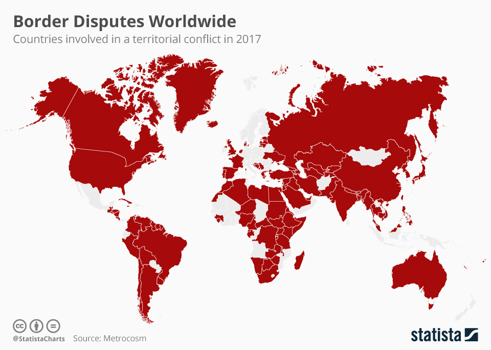
There are many other types of border conflicts spanning the entire globe, each with their own unique nuances, oftentimes embedded in the identities of those nations and their peoples. The below map of Border Disputes in 2017 from Statista with data from Metrocosm demonstrates how pervasive border disputes and conflicts are globally. While this map is map is from 2017, it shows that there are very few areas of the globe not experiencing some level of border dispute.
References:
Biger, G. (2020). Historical geography and international boundaries. European Review, 29(1), 69-77.
Michalopoulos, S. and Papaioannou, E. (2017). The contemporary shadow of the Scramble for Africa. In S. Michalopoulos and E. Papaioannou (Eds.), The long economic and political shadow of history, volume 2 (50-65). CEPR Press.
Prah, K. K. (2004). African Wars and Ethnic Conflict - Rebuilding Failed States [4]. Human Development Report Office Occasional Paper.
Wubneh, M. (2015). This land is my land: The Ethio-Sudan boundary and the need to rectify arbitrary colonial boundaries. Journal of Contemporary African Studies, 33(4), 441-466.
4.6 Potential Role of Geographic Information Systems and Cartography in Border and Boundary Conflict and Negotiations
Speaking to the interdisciplinary nature of geography, the formalization of borders as territorial limits and their linear nature also surfaced around the time of more accurate maps to draw these borders on (Szary, 2015). Maps are often viewed as truth, as an authority, as infallible. In the geographic discipline, we know this is not true, as maps are representations of the world as cartographers see it: their biases, beliefs, identities, and all. This geographic truth is not necessarily understood by those viewing maps, and the psychology behind the perceived truth of maps is well-studied (Von Reumont, 2021; Monmonier, 2018; Wright, 1942). This makes maps a powerful tool to convey identity.
Depictions of Contested and Conflict Areas in Digital/Web Cartography
In the past, it was rather easy for sovereign entities to regulate paper maps; however — with the rise of the internet, digital cartography, and volunteered geographic information — the content of maps, including their borders, are becoming more difficult to regulate. After Google Earth’s launch in 2005, many governments, including South Korea, Thailand, Australia, and India, expressed concerns over the high-resolution imagery that was available through the platform and the security implications for groups getting imagery for sensitive areas (Kumar, 2010). The high-resolution imagery wasn’t the only controversy Google Earth had to face: boundary representation was also an issue. Boundary representation issues included the Israeli-Palestinian border, where Google was accused of having an anti-Israeli slant; the Morocco-Western Sahara border; and the India-Pakistan border, especially with regards to Kashmir (Kumar, 2010; Von Reumont, 2021). The India-Pakistan dispute with Google was resolved by Google using differently-colored boundaries to denote the differences and disputes; however, these examples really illustrate how representations for national boundaries are controversial and speak to national identity.
In addition to boundary placement, place names have also become a point of contention in digital/web cartographic applications. Place names help convey a national identity and pride, and often symbolize territorial claims (Medzini, 2017). Different countries, languages, and cultures often have different names for different geographic features. Take, for instance, what we know in the United States as “Mount Everest.” In Nepali and Sanskrit, this mountain is referred to as Sagarmatha. In Tibetan it is referred to as Chomolungma. There are even different names for it in Chinese (Hunt 2021). While this example is less controversial than other examples, it definitely illustrates how multiple names can be used to reference one geographic feature. More controversial examples include the East Sea/Sea of Japan and Dokdo/Takeshima Islands disputes between South Korea and Japan, respectively (Medzini, 2017). Medzini (2017) illustrates that the ways digital and web maps decide to label these disputed areas can lend credence to one side over the other; however, even their compromises in an effort to remain neutral are often met with resistance. For example, in regard to the Dokdo/Takeshima Islands dispute, Google users in Korea will see the islands labeled as “Dokdo,” while Japanese users will see “Takeshima’ (Medzini, 2017). Other international Google users will see the name “Laincourt Rocks,” which is considered a more neutral name as it doesn’t indicate which country has territorial control over the area; however, this solution was not seen as satisfactory to either country (Medzini, 2017).
Use of GIS in Border Negotiations
Just as digital cartography and Web GIS have contributed to the disputes and territorial conflicts worldwide, it also has the ability to help in negotiations to resolve these conflicts. The emergence of GIS came with a slew of capabilities that could be useful in border negotiations, including but not limited to the ability to layer and overlay quickly and efficiently (and also remove those layers); greater flexibility; increased accuracy; the ability to edit on the fly, make rapid changes, and make calculations based off those changes; and the ability to concurrently show multiple different options (Branch, 2017). In addition, the emergence of three-dimensional GIS and high-resolution imagery has added a sense of realism to these cartographic inceptions that make them easier to imagine for the parties in a negotiation (Branch, 2017). While these capabilities of GIS and Web GIS have clear utility in negotiations, many of these capabilities are a double-edged sword, providing benefits to negotiators as well as creating some problems. Consider, for a moment, this conundrum and how these capabilities may help as well as hinder negotiations.
References:
Branch, J. (2017). Territorial conflict in the digital age: Mapping technologies and negotiation. International Studies Quarterly, 61(3), 557-569.
Britannica. (2021, May 13). Mount Everest [5].
Kumar, S. (2010). Google Earth and the nation state: Sovereignty in the age of new media. Global Media and Communication, 6(2), 154-176.
Medzini, A. (2017). The role of geographical maps in territorial disputes between Japan and Korea. European Journal of Geography, 8(1), 44-60.
Monmonier, M. (2018). How to lie with maps, 3rd ed. University of Chicago Press.
Szary, A-l. (2015). Boundaries and borders. In J. Agnew, V. Mamadouh, A. J. Secor, and J. Sharp (Eds.), The Wiley Blackwell Companion to Political Geography (pp. 13-25). John Wiley & Sons, Ltd.
Von Reumont, F. (2017). Taking the battle to cyberspace: Delineating borders and mapping identities in Western Sahara. In A. Strohmaier and A. Krewani (Eds.), Media and Mapping Practices in the Middle East and North Africa (pp. 13-25). Amsterdam University Press.
Wright, J. K. (1942). Map makers are human: Comments on the subjective in maps. Geographical Review, 32(4), 527-544.
4.7 ArcGIS Online Small Group Exercise: Delineating Borders for Kurdistan
Introduction:
National borders often shift over time, in response to a variety of different motivations, including military conquest, quest for resources, and resolving conflicts. At times, the borders that are delineated are not representative of the populations that reside in the areas being partitioned. This is true with regards to the present-day borders in the Middle East and the movement to develop a Kurdish State: Kurdistan.
Overall Task:
Individually, you will read the provided resources and assess the data provided to you in the ArcGIS Online Group for this class. You will then delineate borders to the best of your ability to create a Kurdistan that would cause the least amount of conflict.
After completing this task individually, you will share your borders with your small group, and together you must negotiate amongst yourselves to develop borders for Kurdistan that each group member agrees with. When the group map is finished, the group members will work together to answer the four questions at the end of the exercise.
Understanding the History:
Why do the Kurdish populations want a sovereign state? To understand the answer to this question, you need to dive into the group’s history. This stateless nation shares an identity and language that dates back to the Middle Ages, even though some Kurds differ in terms of their religious beliefs (Blakemore 2019). We will not deep-dive into the history of the Kurds too far, but understand that they share an ethnic identity that ties them, which feeds their desire for their own sovereign state.
To understand more about what happened, please read the following article about the Sykes-Picot Agreement [6] and its lasting impacts on the Middle East, especially with regards to its impact on the Kurdish population.
The splitting of the formerly continuous Kurdish population amongst several countries has been seen as problematic. This minority population within several countries (including Turkey, Iraq, Syria, and Iran) have often faced difficulties in expressing their cultural identity. There have often been conflicts within Turkey, Iraq, Syria, and Iran with regards to the Kurdish populations. Please view the following video to help demonstrate some of the conflicts within Turkey, Iraq, and Syria.
Investigating Previous Proposals for the Kurdistan State and Ethnic Boundaries:
While Kurdistan has never actually been formalized as a nation, the geographic expanse of Kurdish populations has ebbed and flowed over time, as do many other ethnic groups. If you’re interested in the various changes to this ethnic population over time, consider viewing the following website (note that you are not required to view the site in order to complete the exercise):
-
The Kurdish Question on the Map [8] (This website, while potentially biased, also provides some context for the delineation of Kurdistan.)
While this website goes into greater depth, this exercise will focus on the delineation of a potential present day Kurdistan. Understanding the people’s history is integral to this delineation, and this exercise will have you compare the Kurdistan delineation proposed in 1920, the Kurdistan delineation proposed in 1945, and the currently-understood geographic spread of areas that are predominantly ethnically Kurdish.
Reference:
Blakemore, E. (2019, August 16). Today, the Kurds are spread across four nations. Who are they? [9] National Geographic.
Task 1:
Compare the Kurdistan delineation proposed in 1920, the Kurdistan delineation proposed in 1945, and the currently-understood geographic spread of areas that are predominantly ethnically Kurdish.
- Using your Penn State credentials, sign into ArcGIS online, and open a new Map viewer.
- Add the following Layers to your map:
- Lesson 4: Kurdistan_1920
- Lesson 4: Kurdistan_1945
- Ethnicity_Middle East
- For the proposed boundaries for Kurdistan in 1920 and 1945, change the colors to something that is easy to compare, and adjust the transparencies. Refer to Lesson 1’s exercise if you need a refresher on how to do this.
- For the Ethnicity_Middle East layer, we want to extract out the Kurdish areas:
- Click on the layer in the contents pane on the left to activate the right-side options.
- Select “Filter” or click the funnel button:

- Click “+ Add Expression”
- Set your expression as follows:
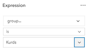
- To do this you will have to replace “statename” with the “group_” field. Then, select “Replace.”
- Then type “Kurds” in the next dialog.
- Before clicking “Save,” note that the area delineating the “Kurds” is a different color than the other ethnicities. Take a moment to click the area where the “Kurds” ethnicity is located. A pop-up will generate, and depending on where you click, there may be multiple options:
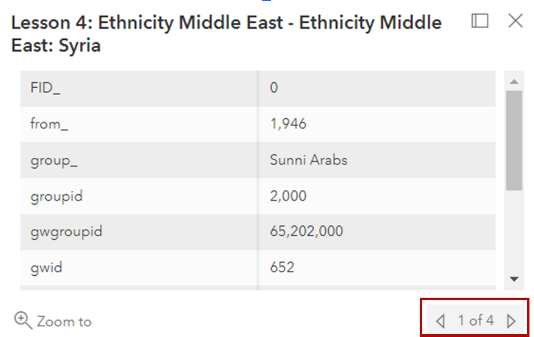
Click the arrows to the right and left at the bottom right of the dialog to determine which ethnic groups are collocated with the Kurds in these areas. (Keep this in mind when you're delineating your boundaries — just because there are areas of Kurdish minorities does not mean there are no other ethnic groups in that area as well.) - Click “Save” at the bottom of the expression pane. Your map should now only display the areas delineated as Kurds.
- Using what you learned in Lesson 1, change the color and transparency to make it easier to compare to the other layers.
Recommendation:
Play with the order of the layers in your map. If one of the smaller areas is “on top” of a larger area, consider changing the layer order by clicking on the layer, holding the left click button, and dragging it to the top.
Questions to consider:
- How do the 1920 proposed boundaries compare to those proposed at the 1945 Conference of San Francisco? What do you think impacted the change in the proposed boundaries?
- How do these proposed boundaries compare to the geographic distribution of predominantly Kurd areas?
Task 2:
Delineating boundaries for a new country is often rife with controversy. To create a new country means taking territory from existing countries, which many countries do not take kindly to. Thus, as described in the Lesson 4 content, the delineation of borders is delicate business, and many considerations must be made before lines are drawn. Will the delineations be adequate for the country being created? Will it mitigate any potential conflicts with countries that territory will be taken from? What concessions can be made to the countries losing territory?
This is your task: taking into account what you know about the region, the Kurds, and the surrounding countries, delineate the borders for Kurdistan.
Recommendations:
- In addition, you may want to add another copy of the Ethnicity layer to your map. This may help you in delineating your boundaries and taking into account areas where there are multiple ethnic groups, not just the "Kurd" ethnicity.
- Take into account not just what the Kurds want, but also consider some of the geopolitical complexities you learned about in the first part of the exercise.
Steps:
- In your ArcGIS online map, add your personal Kurdistan delineation Feature Layer. This layer will say “Kurdistan_[insert your last name here].” Please only use the one that has your last name. If you do not see one that has your last name, please let your instructor know, so they can create a Feature Layer for you. This is the layer you will edit.
- Make sure to click on your Kurdistan layer to activate the tools associated with it. If your right-side toolbar is collapsed, click the two carrots on the bottom right to open the menu.

- Under the “Search” option, please select “More.”
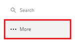
- Select “Edit.”
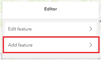
- The editor toolbar will appear, with two options: Edit Feature or Add Feature. You want to “Add Feature.” Please click on “Add feature.”
- Follow the prompts in the dialog and begin drawing your boundaries for Kurdistan.
- Double Click when you’re finished.
- It will ask you for an “ID” attribute. Please enter any integer (non-decimal) number.
- Be sure to save your changes using the left-hand menu. If your menu is collapsed, please click the carrots on the bottom left of the menu (just as on the right-hand menu) to expand your options. Click “Save and Open” and save your map.
Questions:
- What considerations did you make in the delineation of these borders? Why did you draw them the way you did?
- What potential conflicts do you foresee in the delineation of your borders? If you were negotiating these borders, how would you mollify these conflicts?
Group Task:
Once you’ve created your individual delineations, post them to your group’s discussion board. Come together, discuss the differences between your delineations, and create one delineation that you all can agree on.
Following the same procedure you did for your individual exercise, use your group’s Kurdistan feature layer (Named: Kurdistan_Group[your group’s number]) to delineate your agreed upon borders.
Group Questions:
- How different were the borders amongst the group?
- How did your group resolve differences if they existed?
- How did your group rationalize your choices with regard to the new borders, individually and collectively?
- What factors did your group prioritize in determining where to set the borders?
Deliverable:
When you have completed the tasks 1 and 2, you should work with your group members to complete the Group Task and answer the Group Questions above. The final submission for this assignment should include the following:
- A screen capture of the group's final map.
- Answers to the Group Questions.
- I am expecting just a paragraph or two to answer each question.
- A description of the division of labor for the assignment including member names and tasks.
When you have completed the assignment, select one group member to submit your document to the Lesson 4 ArcGIS Online Group Exercise dropbox.
The assignment should be submitted to the Lesson 4 ArcGIS Online Group Exercise dropbox, which contains specific instructions for submitting the assignment. I am expecting just one submission per group.
Please check the Canvas Syllabus or Calendar for specific time frames and due dates.
4.8 Research Project Outline and Annotated Bibliography
This week you will have an outline for your research project and an annotated bibliography due.
Research Project Outline
The research project outline should provide an overall framework for your research project:
- How is it structured?
- What are important sub-topics related to your research project?
- What points do you intend to make related to your research? (With the understanding that this part is developing as you work on the project.)
Your outline should contain enough information that someone reading it can understand how you are thinking through the project and how your analysis is shaping up. Please review the Hunter College Guidelines for Outlining [10] and follow the conventions described there in our outline. We strongly encourage you to use a sentence outline rather than a topic outline.
While this framework/outline may change a little as you progress through your research, it should serve as the guiding force throughout your research project.
Annotated Bibliography
Your annotated bibliography is a brief synopsis of the literature you have been reading in reference to your research project. At this point, your annotated bibliography should have at least ten entries.
Each entry should be no more than 2 to 5 sentences in addition to the citation. Important aspects of annotated bibliography entries include:
- Literature citation in APA format,
- Brief synopsis of the literature,
- Brief assessment and reflection on the relevance (or lack of relevance) to your subject.
- Note: Keeping track of articles that do not pertain to your research project is just as important as keeping track of those articles that are pertinent. These articles can provide you with search terms that you may want to avoid, etc.
An annotated bibliography is not the literature’s abstract.
Resources
Cornell University’s Library provides excellent examples of annotated bibliographies [12] to be emulated for your assignment.
Deliverable:
When you are ready to submit your research project Outline and Annotated Bibliography, please return to Canvas and open the 4.8 Research Project Outline and Annotated Bibliography dropbox in the Lesson 4: Identity II - Boundaries and Identity module.
4.9 Summary and Final Tasks
Summary
In this lesson we introduced the concept of boundaries and borders and their relationship with what you learned about identity in lesson 3. We discussed how borders, boundaries, and identity are impacted by scale and how they can influence conflicts around the globe. Finally, we evaluated the role GIS can play in conflicts, both as a perpetrator and a negotiator for peace.
Deliverable:
Please take the Lesson 4 Quiz. Return to the Lesson 4 module in Canvas where you will find the quiz.
Please check the Canvas Syllabus or Calendar for specific time frames and due dates.
Final Tasks
Complete all of the Lesson 4 tasks
You have reached the end of Lesson 4! Double-check the to-do list on the Lesson 4 Checklist page [13] to make sure you have completed all of the activities listed there before you begin Lesson 5.
Questions?
If you have any questions now or at any point during this week, please feel free to post them to the GEOG 571 - General Discussion Forum. (That forum can be accessed at any time in Canvas by opening the Lesson 0: Welcome to GEOG 571 module in Canvas.)