Overview
Spatial clustering methods are useful for making sense of complex geographic patterns. In this week's lesson, we look in a more general way at the various approaches that spatial analysts and geographers have developed for measuring spatial autocorrelation.
Learning Outcomes
At the successful completion of Lesson 4, you should be able to:
- define spatial autocorrelation with reference to Tobler's 'first law' of geography, and distinguish between first- and second-order effects in a spatial distribution;
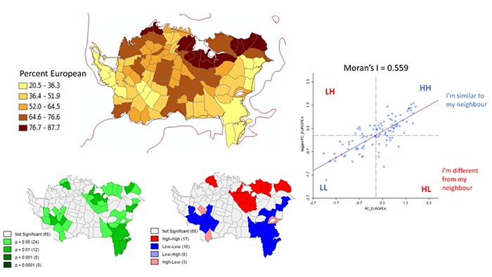
- understand how to compute Moran's I for a pattern of attribute data measured on interval or ratio scales;
- explain the importance of spatial weights matrices to the development of spatial autocorrelation measures and variations of the approach, particularly lagged spatial autocorrelation;
- explain how spatial autocorrelation measures can be generalized to compute and map Local Indices of Spatial Association (LISA);
- describe how Monte Carlo methods may be used to determine significance for LISA.
Checklist
Lesson 4 is one week in length. (See the Calendar in Canvas for specific due dates.) The following items must be completed by the end of the week. You may find it useful to print this page out first so that you can follow along with the directions.
| Step | Activity | Access/Directions |
|---|---|---|
| 1 | Work through Lesson 4. | You are in the Lesson 4 online content now. Be sure to carefully read through the online lesson material. |
| 2 | Reading Assignment |
Before you go any further, you need to read the portions of the course text associated with this lesson:
After you've completed the reading, get back into the lesson and supplement your reading from the commentary material, then test your knowledge with the quiz. |
| 3 | Weekly Assignment | This week's project explores ethnic residential segregation in Auckland, New Zealand using spatial autocorrelation measures provided by the GeoDa tool. |
| 4 | Term Project | Finalize your Term Project Proposal for the peer review next week. |
| 5 | Lesson 4 Deliverables |
|
Questions?
Please use the 'Week 4 lesson and project discussion' to ask for clarification on any of these concepts and ideas. Hopefully, some of your classmates will be able to help with answering your questions, and I will also provide further commentary where appropriate.