GEOG 858 Syllabus
Spatial Data Science for Emergency Management
Fall 1, 2020
Course Overview
Prerequisites: There are no prerequisites but GEOG 483, Problem Solving with GIS, is a recommended preparation.
Course Materials
What's this course about?
MATT BEATY: Hi, I'm Matt Beaty, the instructor for Geography 858, Spatial Data Science for Emergency Management. Thanks for taking the time to have a look at this course, this syllabus. And I want to just tell you a little bit about the course. And hopefully, it'll address any questions that you may have in looking over the material below.
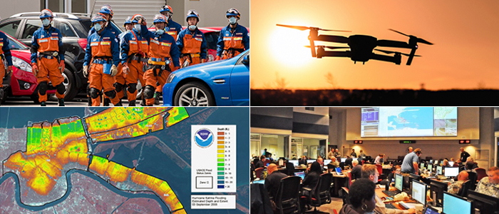
The earlier version of this course focused primarily on geographic information systems and the ways that GIS can be implemented in an emergency management context. So the focus is really more on design, and in particular, systems for GIS and emergency management. The course has been redeveloped now, so it's quite different in its focus. So now the emphasis is on spatial data science and the technologies that are emerging to change practice in emergency management to incorporate a whole range of sort of new techniques in data, data sets.
So it's really focusing on how the area is being transformed. So if you have an interest in emergency management, I think this will be of interest. But if you just have a-- or if you have a more general interest in emerging geospatial technologies and data and analytical approaches, you'll probably find this an interesting course and application as well.
So some of the emerging techniques that we'll encounter are very familiar, so things like unmanned aerial vehicles, volunteer geographic information, crowd sourcing, those sorts of things. Others will be a little less familiar, including topics like geospatial artificial intelligence, near real-time or real-time spatial data analysis, as well as just some other novel approaches for dealing with issues sort of around logistics, humanitarian logistics, and the roles that agencies play with communities and those sorts of things. So there is the hard sort of technical-- technological advances, but then there's also different perspectives about how we need to approach emergency management situations.
So what will we do in this class? Well, the activities are quite varied. So they'll be quite a bit of discussion amongst ourselves, which I'll talk about in a minute, hands-on exercises, group collaboration work, and the development of a term project.
So let me just start by talking a little bit about the collaboration component of this assignment. Now sometimes, people hear collaboration or group work and kind of roll their eyes. But this set of topics that we'll be considering here really require people to get together and talk through complex problems and bring their understanding of the world together.
We'll accomplish this in a couple ways. Each week, there'll be content, a reading, watching a video, looking at various example websites, that will present a topic. It might be something like geographic artificial intelligence. You'll take what you've learned from those readings and you'll bring them into the discussion forum where there's a set of sort of standard deadlines you'll need to meet in terms of what you cover with your classmates in that forum.
So the idea isn't that it's like super heavy or anything, but the idea is that you bring insights to it from your understanding of the reading, and then you grow sort of organically. That might not sound very exciting to begin with, but I think if-- what we found in the past with these courses is that students quite like that a lot. You let them sort of talk about their understanding of the material, but then also to provide their insights and be creative as well in terms of how they interact and the points they bring.
The interaction is very important in this class. It also comes in in a couple of your hands-on assignments where you'll work in groups, small groups, to-- I think in one instance, you are developing scenarios looking at a particular disaster, and at how different phases of that disaster were sort of addressed or could have been addressed better with spatial data science. Another example is you'll develop sort of a more critical view of what happened in a particular disaster and do a bit of a critique of that.
You'll be doing a bit of analysis and writing, and then the idea is that you'll summarize that at the end of it using an Esri story map. So you'll be using a very sort of media rich environment to tell the story that you have to tell. And this is increasingly a skill that's highly sought, I think, in terms of being able to communicate the data in these sort of non-traditional ways to different stakeholders. So it should be kind of fun.
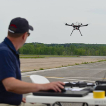
The next bit to mention, I guess, is around the hands-on assignments. You'll work with a particular data set. For example, in the second lesson, there's a lab on using unmanned aerial vehicle data to look at a few different scenes that might represent a landscape that first responders or others would be going into to try to address a problem.
And you'd be the analyst developing the spatial products to provide advice about where to go, where not to go, those sorts of things. So that will-- in that, you'll consider both 2D and 3D drone imagery. And the idea is to really give you a flavor for what's sort of happening in this space and how we can really narrow that critical time period between the disaster and the production of spatial products, reduce that as much as possible so that the response can be more effective.
The final assessment, I guess, I'd like to just mention is the term project. And this one's really key and quite important, because it's your opportunity to really tailor the class for you. You can pick a wide range of topics. I'm pretty easy. Early on in the piece, you're basically be doing a pitch of your idea and what you would like to do, and I'll provide you feedback on that.
The vehicle for that is an abstract followed soon by an outline where you sort of flesh out the details. So you'll get lots of feedback early on to make sure you're on track, and that you're doing something that's possible in the time you have available. And then you develop the first draft, and then a final draft. And then those-- through that process, I'm with you and am providing feedback along the way.
So you could do topics that relate more to more conceptual and design issues, or you could do something that's pretty hardcore, data-driven. So it really just depends on your interests and the like. At the end of this process, we do five-- you'll create a five to seven minute short video that explains what your topic was and what your findings are. And that will be available for the rest of the students to look at. Also it's something that you could sort of take with you.
So I should've mentioned that with the term projects, in the past, a lot of the students have been able to take their work and actually show it to their employer, in some cases, as a proposal for what they think should be-- that their organization should be doing. In other cases, it's formed a very solid draft of what would be a journal paper. So I think at the very least, you can come out of this with a bit of a portfolio. So from your Esri story maps to your term paper, the very strong applied and very strong emphasis on technology and data and the like, and that, coupled with your communication products, like the video that you'll do.
So anyway, that's really, I guess, what I wanted to cover. Probably covered more than I meant to say. But if you have any questions about this course and would like to know more, or like to understand if it fits with what your goals are, what you want out of a more detailed understanding of spatial data science as applied to emergency management, please don't hesitate to get in touch with me or with one of the people in the program office. They can help hook us up as well.
The only hitch on my end is that I'm based in Australia. So I live in Melbourne, Australia. So there can be a bit of a delay in communication.
But in the past, that's been something we've all had to deal with. We've had, in a given class, people from all over the world. But we can definitely sort of work around any of those issues.
Anyway, thanks again for listening. And please have a look at the rest of the page in the syllabus if you want to kind of know what we're doing. Right now, we only have lesson 1 open. And the reason we do that is that this is a paced course.
Because of all the interactions and the requirements of the data assignments, we're really trying to limit you to not working more than a couple weeks ahead. And I know that doesn't always fit well with people's schedules and the like, but-- well, in a sense, that's how this course has to work. So if that's an issue, we can talk about it. We have examples where other students have been able to manage this as well.
Great, well, thanks again. And I'll talk to you soon, hopefully. Bye.
#coursegoals
By the end of our semester, you will have cultivated an in-depth understanding of the policy mechanisms employed to address energy challenges at a variety of geographic scales and you will have developed a polished research project on a topic of your choosing. We'll be busy, but it'll be fun!
Assignments and Grading
| Letter grade | Range |
|---|---|
| A | 90 - 100% |
| A- | 87.5 - 89.9% |
| B+ | 85 - 87.4% |
| B | 80 - 84.9% |
| B- | 77.5 - 79.9% |
| C+ | 75 - 77.4% |
| C | 70-74.9% |
| D | 60-69.9% |
| F | < 60% |
| X | Unsatisfactory (student did not participate) |
Late Policy
All assignments are subject to a 10% per day late penalty (exclusive of extenuating, approved circumstances).
Life Happens. But I can’t accommodate you with flexibility in assignment deadlines if you’ve not communicated with me in advance. Don’t drop off the radar for weeks and then tell me something had happened, let’s handle things up front to prevent extenuating circumstances from negatively affecting your grades.
Our Schedule
FAQs
Why is there so much discussion in this class?
Studies have shown that learning is a social process that leads to increased student performance and satisfaction. Through discussion, students are able to learn from one another, experience differing viewpoints, opinions, and ideas and be stretched intellectually. I will be monitoring the discussions and participating periodically but I expect most of the conversation to come from you. This should be a discussion, not simply a smattering of random posts, so please ask (and answer) questions of your peers, pose differing views, and engage regularly. My expectations are detailed in the course but please note that you will be required to post on at least three different days each week. To reiterate. I am more interested in a conversation and seeing that you are reading and participating on a regular basis throughout the week.
Discussions are also important to prepare you for continued success in the workforce. This field requires all participants to work in teams to solve emergency management solve problems.
In order to facilitate a true discussion, rather than just some random posts, I will leave the discussions open for a week and a half. Please plan to make your initial post by day 5 and then schedule your time so you can come back into the class on THREE SEPARATE days to comment and discuss. In the past, I have found that students wait until the last minute and then post the minimum number of replies. I am more interested in seeing that you are reading and participating on a regular basis rather than a number of times.