Lesson 1: Introduction to Project Management
Lesson 1 Introduction
Lesson 1-Introduction to Project Management
Lesson 1 Overview
In this lesson, you are introduced to project management concepts and practices. This will set the stage for subsequent lessons, in which you will apply key practices and methods to practical project scenarios. The lessons in this course follow the approaches and practices espoused by the Project Management Institute [1] (PMI) and other authoritative sources on best practices for project planning and execution. These best practices apply generally to all types of projects, but in this course, we will be focusing on their application for IT and GIS projects. First, let's review some key terminology:
- The PMI defines a project as a, "temporary endeavor undertaken to create a unique product or service". Take special note of the words, "temporary" and "unique product or service". Every well-conceived and well-planned project should have clear start and end dates and well-defined end results or deliverables.
- Most projects focus on the creation of one or more deliverables. A deliverable is a specific product or defined result for work carried out in the project. In a GIS context, this could be a report or document (e.g., GIS Needs Assessment), a GIS data product (e.g., traffic sign inventory with point locations and sign attributes), or a tested and deployed Web-based GIS application.
- The PMI defines project management as, "the application of knowledge, skills, tools, and techniques to project activities to meet the project's requirements". Project management is accomplished through the application and integration of what the PMI refers to as process elements--interrelated sets of activities for launching, planning, successfully executing, and formally closing out a project. We will take a closer look at these process elements in the next lesson.
Why get serious about project management? For some very good reasons that directly impact the project's cost, timing, and how well it accomplishes stated requirements:
- to put the project manager, team, and the organization in the best position to meet project objectives and deliver results;
- to make the best and most efficient use of resources--primarily money and people's time; and
- to provide an effective means to anticipate and deal with changes and problems--which arise in nearly all projects.
Taking the time to put in place a sound project plan and applying best practices for project execution and monitoring just makes sense!
Learning Objectives
By the end of Lesson 1, you should be able to:
- understand what a project is, and the difference between a project, a program, and a product;
- grasp the relationship between a project's objectives and the mission and goals of the organization for which the project is being carried out;
- describe project management and its key elements;
- characterize the organizational and business context of a project (project team, stakeholders, and business requirements); and
- recognize the factors that contribute to an effective project plan and management approach.
See the checklist page for readings, quiz, and assignment work in this Lesson.
Questions or Topics to Post
Questions about this assignment or any other topics for the instructor are best submitted to the email address or by direct phone call to the instructor. Also, feel free to communicate with your fellow students via the Discussion Forum or email.
Lesson 1 Checklist
Lesson 1 Checklist
Lesson 1 is one week in length (see the Calendar for specific due dates). To finish this lesson, you must complete the activities listed below. You may find it useful to print this page out first so that you can follow along with the directions.
| Step | Activity | Directions |
|---|---|---|
| 1 | Reading | Lesson 1 online course content in Canvas |
| 2 | Reading | Article by Hamil [2] |
| 3 |
Reading |
Croswell Chapter 1 (Sections 1.1 to 1.4) and Chapter 9 Note: Chapter 9 provides an overview of project planning and management topics. Don't worry if you don't fully grasp all of the concepts and methods. We will come back to them in subsequent lessons. |
| 4 | Assignment 1, Part 1: Begin report on a project and its fit to an organization’s vision | Assignment 1 (Parts 1 and 2) due at the end of Lesson 2 |
| 5 | Participate in Week 1 Discussion Forum:
|
For this lesson and all subsequent lessons, you are required to enter postings for the Discussion Forum set up for the lesson. This is one way you will communicate with other students and your instructor and present your ideas, examples, agreement, or elaboration of course material, etc. Suggested topic - Let your classmates know about the worst project you've worked on, and why. |
Project Constraints
Project Constraints
Inherent in the definition of a project are the constraints that will affect any project. These constraints reflect the key elements of our project definition:
- It has a unique purpose and specific deliverables → Scope constraints.
- It is temporary, with specific dates associated with tasks and milestones → Time constraints.
- It requires staff time, money, and physical or technological assets (e.g., software, computer hardware, etc.) → Resource constraints.
The Scope constraints address project deliverable requirements and meeting the specifications (functionality, content, format, quality) associated with those deliverables or planned project results. The Time and Resource constraints set boundaries for planning and executing the work. These are often called the "triple constraints" of project management, and changing any one of these is sure to have an effect on the other two. A key ingredient in successful project management is carefully defining these constraints for each project and controlling any changes that may occur during the project. Of course, any of these constraints can be eased at any time by compromising the quality of the project. In this class, we will assume that this is not an option that we are anxious to explore!
Project Management as a Discipline
Project Management as a Discipline
Key Project Management Concepts and the PMI
Project management is the application of knowledge, skills, tools, and techniques to project activities in order to meet project requirements--all focused on delivering desired results on schedule and on budget. In geospatial projects, results are often defined deliverables--tangible products or results of project work which are well-defined in a project plan. For example, in a project with the objective of developing a GIS database, deliverables could include processed aerial imagery or LiDAR elevation data ready to load into the GIS database for access by users.
Project management is not a new field, but it is a discipline that has been formalized greatly over the last 30 years with a range of documented methods, best practices, and automated tools to support projection planning and execution. A Guide to the Project Management Body of Knowledge (PMBOK), 7th Edition. This document can be obtained by online order [3]. This PMI is the world's leading professional association that develops and promotes project management standards and best practices (for all types of projects). The PMI also offers a number of project management and program management professional certifications--the Project Management Professional (PMP) certification being the most popular and widely recognized. Students are encouraged to examine the materials from the PMI and pursue one of its certifications. Take a look at the PMI website [4] and build some awareness of the scope and services of this organization. While not a mandatory text for this course, we recommend that you consider obtaining a copy of the PMBOK and use it as a reference guide for the planning and management of future projects.
Standards Organizations
There are a number of government and independent organizations which develop, adopt, and promote the application of standards associated with IT and GIS. Some of the more important standards bodies include:
- The International Organization for Standardization [5] (ISO) includes groups that develop and formally adopt standards pertinent to a wide variety of topics and disciplines. The ISO Technical Committee 211 (TC211) deals specifically with geospatial technology, practices, and data.
- The National Institute of Standards and Technology [6] (NIST) is a U.S. government organizations that codify a wide range of standards, some of which impact geospatial and IT projects.
- Federal Geographic Data Committee [7] (FGDC) is a U.S. Federal government committee which develops and promotes standards and best practices related to GIS data and database development and maintenance.
- Open Geospatial Consortium [8] (OGC) is an independent body with wide participation of geospatial technology product and service vendors, government organizations, and other types of organizations. Its mission is to develop, approve, and promote the use of standards for geospatial data, software, services, and practices that maximize open access and integration among geospatial products.
- American National Standards Institute [9] (ANSI) is a U.S.-based independent standards organization that develops and adopts standards on a wide range of topics (including information technology).
In addition to these formal standards bodies, there are a large number of professional organizations that promote standards and best practices for the development, use, and management of geospatial technology. Two of the most prominent are the Urban and Regional Information Systems Association (URISA [10]) and the American Society of Photogrammetry and Remote Sensing (ASPRS [11]). Also, there are many discipline-specific professional associations that have committees or groups that address geospatial issues.
The Project Management Framework
The Project Management Framework
Introduction
Project management frameworks are efforts to understand the scope of a project and project management topics in a holistic sense. They go beyond the constraints discussed above to include all aspects that may influence a project. Schwalbe offers the following framework:
- Stakeholders' needs and expectations
- Project management knowledge areas
- Tools and techniques
- Project portfolios
Schwalbe illustrates the relationships between these various aspects of the project management framework in Figure 1-1 below.
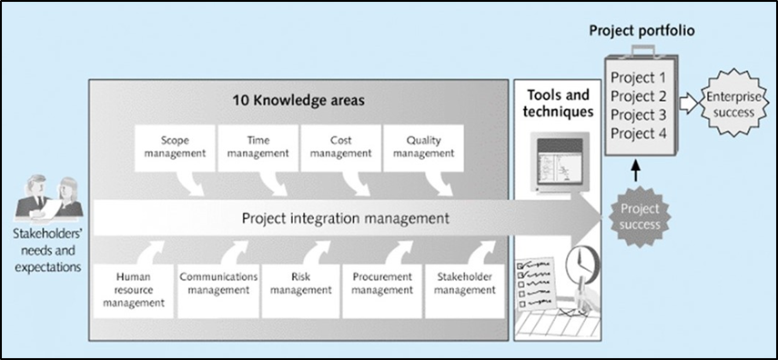
Click for a text description of Figure 1-1
This figure shows how the ten project management Knowledge Areas, represented as boxes arranged horizontally, reflect the needs and expectations of stakeholders and support successful project planning and execution. These knowledge area boxes: Scope, Time, Cost, Quality, Human Resources, Communications, Risk, Procurement, and Stakeholder Management have arrows that connect to a central arrow labeled as "Project Integration Management". Through the use of project integration management tools and techniques, these "Knowledge Areas" come together in project planning and execution to deliver project success--full completion of the scope within planned time and resources. Project success, represented as a circular symbol, connects to a box called listing multiple projects in an organization's "project portfolio" to deliver "enterprise success" represented as a circular symbol.
Each of these components is described below. The components of the framework are briefly described below and explained in more detail in Schwalbe Chapter 1.
Stakeholder Needs and Expectations
Stakeholders can be anyone or any organization that has an interest or involvement in the project. The term "stakeholder" is normally used in a general sense to identify people or organizations that will have some role in a project (e.g., review or approval of project deliverables) or which are more broadly impacted by the project work or results (e.g., employees or management personnel inside the organization carrying out the project). The group or organization which sponsors a project and expects to derive benefits from project results may be considered "customers". Project results and tangible deliverables should focus on the customers' business requirements, which are work assignments and associated resource needs necessary to support an organization's mission and goals.
Project Management Knowledge Areas
As described by the Project Management Institute (PMI), project management Knowledge Areas address critical concerns and practices that must be taken into account in project planning and execution. The PMI Knowledge areas are:
- Core knowledge areas
- Scope management
- Time management
- Cost management
- Quality management
- Facilitating knowledge areas
- Human resources management
- Communication management
- Risk management
- Procurement management
- Stakeholder management
- Integrative knowledge areas
- Project integration management
A look at our syllabus reveals much of the class is organized based on these knowledge areas. It is not possible to create a project plan without a detailed look at the plan's scope, timing, and cost. In addition to these, we will discuss all of the other important knowledge areas you must be familiar with to be a successful project manager.
Tools and Techniques
Tools and techniques can help to increase understanding in any of these knowledge areas, but are most vital in the core knowledge areas. We will explore a variety of these techniques and discuss their implementation in GIS projects. Although project management software packages can facilitate the use of these tools and techniques, the same techniques have long been used with pencil and paper.
Project Portfolios
A project portfolio is a collection of projects that are grouped together to facilitate effective management of work to meet the projects' objectives). Project portfolio management integrates the planning and management of individual projects into a larger entity that can be aligned with an organization's mission and business requirements. The process is similar to investment portfolios that look at all holdings and attempt to achieve a balance between risk and potential reward.
GIS Project Management
GIS Project Management
There is no fundamental difference between the planning and management of GIS projects and other information technology projects. In fact, the PMI develops and promotes project management standards from a premise that all types of projects can benefit from a common set of practices and methods. In this course, we will adopt this general concept and show how PMI standards and practices apply to GIS environments.
As we progress through this class, keep in mind the following concepts:
- definition of a project
- scope of project planning and management as explained through the PMI "Knowledge Areas" and "Process Groups"
- project constraints (scope and deliverable specifications, time, and resources)
- focus on specific project results and deliverables that meet customers' business requirements and the organization's strategic mission and goals
Let's jump into the first assignment of looking at the fit between a project undertaken by an organization and the organization itself.
Assignment #1-Project Fit to Organization (Part 1)
Assignment #1-Project Fit to Organization (Part 1)
Assignment #1 (Part 1) Overview
Timing: See Canvas Calendar for timing
Target Word Count: about 1800-2500 words total for Parts 1 & 2 combined
Total Points: 60 points - see rubric for details (scroll to the bottom of this page)
Assignment #1 spans Lessons 1 and 2. The entire assignment will be due at the end of Lesson 2; however, please begin Part 1 of the assignment NOW (by following the directions below) because it is relevant to what we've just discussed in this lesson. Furthermore, starting now will help you to manage your workload! Also, students sometimes need time to gain permission to use a work project as a class assignment. If this is the case with the project you are considering, begin seeking permission early.
Assignment #1 entails examining the fit between a GIS project done by an organization and that organization's mission and strategic goals. In Part 1 (this week's assignment), you will describe a GIS-related project done by an organization. In Part 2 (next week's assignment), you will document the organization's mission and goals and discuss how the project supports that mission.
Your Submittal - Part 1, Assignment #1
For Part 1 of Assignment 1, first identify and describe a GIS-related project--it works best to find a project that has a clear set of deliverables and an organization who benefits from them.
Some examples of GIS projects include:
- Aerial or field-based spatial data collection and processing (orthoimagery, field-based inventory of natural resources or utility features) for a local government or utility organization
- A GIS program needs assessment carried out as a basis for development of City enterprise (multi-Departmental) GIS program
- Design and development of a custom Web-based GIS application
- Preparation and specifications for procurement of GIS software and computer server resources
- Major GIS software upgrade and re-configuration
- Other time-limited projects with specific results or deliverables
After selection of a suitable project, present a summary description of the project that includes the following:
- Cover page
- Identification of the organization’s name (identify main organization and specific department or division carrying out the project)*
- Name of the project (if you cannot find a clear name of the project you select, make up one that describes the work and results)
- Summary of project objectives, tasks, and deliverables. The summary should be 2 to 3 paragraphs with bullet lists as appropriate. If the project is very detailed (with many tasks and subtasks) it is OK to summarize the project at the major task level. Don't get into too much technical detail.
- Summary of project timing: Include some key milestones of project execution beginning with project start and some main activities and deliverable completion points. Timing may be expressed by actual dates or as "days from project start". A bullet list work well for this.
- Project team: Identify the key team members (including the project manager) as well as other key people on the team. A positon role in the project (e.g., Project Manager, GIS Analyst, etc.) should be identified. If project team members come from multuple organizations, the organization affiliation should be noted.
- Your insights into how the project you described relates to material from Lesson 1 (Canvas material and readings).
*If you choose a project being carried out by a contractor for a client organization (e.g., acquisition and processing of aerial imagery for a local government), it is the client organization (e.g., local government agency) that should be identified. The mission and “project fit” that you will describe in Part 2 should be for the client organization, not the contractor.
You may base your project description on one in your current organization, one you have worked for in the past, or one carried out by a colleague in another organization. Another way to identify and select a suitable project for this assignment is to search the Web for "request for proposals" (RFPs)* or "project plans", "project charters", or "project reports" that summarize objectives, scope, deliverables, schedule for GIS-related projects. If you choose to use this Web search approach, enter such key phrases as "RFP", "project plan", "GIS", "database development", "application", "design", "needs assessment", etc. You may also find some examples of projects by looking at archived presentation summaries from GIS conferences (e.g., URISA GIS-Pro Conference, Esri User Conference). You will find documents for multiple projects that should work, and, in many cases, these documents will provide organizational background, mission statements, etc. For this assignment, it is acceptable to make edits, revisions, and to modify information of an actual project if necessary (changing or modifying names, deliverables, etc.). The best types of projects to use for this Assignment are those that have clear objectives and deliverables and are not too complex in terms of tasks and the stakeholder environment. Also make sure you can identify the organization that is the source or sponsor of this project (e.g., Department in a State or local government) and the organization's mission and goals. Contact your instructor if you have difficulty selecting a project or questions about the suitability of a project example you have come up with.
Notes:
- Regardless of the document(s) that you use as a source for this assignment, you'll need to do some additional research (e.g., about the mission and business focus of the organization) and also make some educated assumptions to add some detail (make up information) to complete the elements of this Assignment. If an RFP is the main source you use for information about the project, remember that the RFP is NOT the project. The RFP is just a formal vehicle with project information used by an organization (usually a government agency) to procure services from a contractor to carry out the work
- If you have identified several possible projects and are not sure about their applicability for this assignment, contact your instructor for help. If you cannot find a project that you think will work for this assignment, you may “fabricate” your own fictitious project, but this likely would require more time on your part.
- For Lesson 1, you should begin Assignment 1—Part 1 as described above. Both parts of Assignment 1 are due during Lesson 2 and should be about 1800 to 2500 words in total. Part 2 involves a description of project fit for the organization. As is the case for all written assignments, the word count is a target to give you an idea about the level of detail expected. As a general rule, it is best to be concise and as brief as possible while covering the necessary topics. No points will be deducted for submittals if they exceed the maximum word count by a small amount. Your submitted assignment should be formatted as specified in the rubric to earn maximum points. The use of the Outline feature of your word processing software is a good document preparation practice.
For Assignment 1, organize the document in a way that concisely covers the topics described in Parts 1 and 2. There is no prescribed organizational format for the required content (i.e., section and subsection ordering). As in all written assignments, you should include a Cover page with prominent title and all necessary information identifying the course, assignment, author, and date. The main title of the document should be "PROJECT FIT TO ORGANZATION". The Cover Page should also reference to the project name and organization. At the bottom of the Cover Page (right side is best), include the course name and number, assignment number, your name, and date.
See more detailed information about document format and submittal in the Part 2 instructions for this Assignment.
The more information available about the project and the organization, the easier it will be to write. Specifically, in addition to detailed information about a project, be sure that information (mission, strategic goals, etc.) about the organization or the specific department or division carrying out the project is available since you will need this for Part 2. Remember, if you choose a project being carried out by a contractor for a client organization (e.g., acquisition and processing of aerial imagery for a local government), the mission and “project fit” that you will describe in Part 2 should be for the client organization, not the contractor.
Submitting the Assignment and the Grading Rubric
To pace yourself appropriately, complete Part 1 of Assignment #1 during Lesson 1 and move ahead with Part 2 as soon as possible. The grading rubric is below.
| Grading Category | Basis for Scoring | Total Possible Points |
Point Award Explanation |
|---|---|---|---|
| A. Inclusion of Required Content |
|
18 |
|
| B. Overall Document Organization |
|
12 |
|
| C. Quality/Clarity of Writing | Writing quality and clarity effectively uses words and sentences to convey meaning to the reader including the following:
|
18 |
|
| D. Format Quality | Well-formatted document helps convey content and meaning to the reading. Important format parameters include:
|
12 |
|