Lesson 2: Organizational System, Project Life Cycle, Processes, and Procurement
Lesson 2 Introduction-Organizational System, Project Life Cycle, Processes, and Procurement
Lesson 2 Introduction-Organizational System, Project Lifecycle, Processes, Procurement
Lesson 2 Overview
In GEOG 871, we will look at projects from a systems approach, focusing on management that is holistic, analytical, and driven by the user's needs. In project management, systems and their management include technological and user issues, and also business and organizational issues. A system view focused on the end users' needs is vital to effective geospatial project management. This should be apparent in the processes employed throughout the life cycle of a project.
Learning Objectives
By the end of Lesson 2, you should be able to:
- describe organizational systems, structures, boundaries, and the roles of users, sponsors, and stakeholders within and outside the organization
- recognize the phases of a project life cycle, highlighting the unique context of GIS projects
- describe the five project management process groups and how each occurs within each project phase
- understand the role and approach for managing project-related procurement of products and services
- appreciate the role of procurement for products and services in the context of GIS projects
See the checklist page for readings, quiz, and assignment work in this Lesson.
Questions?
If you have any questions or would like to brainstorm ideas, please contact the instructor by phone or email. Also, feel free to communicate with your fellow students via the Discussion Forum or email.
Lesson 2 Checklist
Lesson 2 Checklist
Lesson 2 is one week in length. (See the Calendar for specific due dates.) To finish this lesson, you must complete the activities listed below. You may find it useful to print this page out first so that you can follow along with the directions.
| Step | Activity | Directions |
|---|---|---|
| 1 | Reading | Lesson 2 Content (Organizational System, Project Lifecycle, Processes, and Procurement) |
| 2 | Reading | Croswell, Chapter 3 (Section 3.1), Chapter 5 (Sections 5.1 and 5.2), review Chapter 9 (Section 9.1) |
| 3 | OPTIONAL Reading | ISD Project Management White Paper--How much? [1] |
| 4 | OPTIONAL Reading | ISD Project Management White Paper--Who is on your side? [2] |
| 5 | Assignment #1, Part 2: Complete report on a project and its fit to an organization’s vision | See assignment instructions (Part 1 and 2) and Canvas Course Calendar for due date. |
| 6 | Participate in Week 2 Discussion Forum:
|
Access Lesson 2 Discussion Forum. Suggested topic - Let your classmates know about the best project you've worked on, and why. |
The Nature of Organizations
The Nature of Organizations
Introduction
Whether you do GIS work for a large corporation, a government agency, a private consulting firm, or yourself, your approach to project management will be strongly influenced by your organization and its approach to business.
Organizations that use GIS
Nearly all organizations that use GIS share some common program and project management concerns and practices, but there are differences of mission, mandate, and structure among public, private, and non-profit organizations that affect how they use and manage GIS. An effective manager should acquire a solid understanding of the workings and structure of his or her organization and the external organizations with which it may interact in providing GIS products and services. This is important because a GIS project or program manager has a responsibility to support the organization’s mission and work within the established laws and policies. It is also likely, if not certain, that a GIS manager will need to coordinate with external organizations in the sharing of data or project coordination. Public-sector governmental agencies at the local, regional, state, and national level have been focal points of GIS implementation because their missions require the collection and use of maps and geographically referenced information. Croswell and Fries (2004) [3] explain the prominence of GIS in the public sector. Private sector organizations using GIS technology include private utility companies, resource and land development firms, surveying and engineering services companies, geographic data providers, commercial and retail businesses, and many other types of private companies. They are profit-driven and use GIS to support their lines of business to develop, integrate, and deliver products and services to customers. Refer to Croswell, Section 1.4 for more information about organizations' use of GIS technology.
Mission Statement
How do you get to know what an organization is about? Stephen Covey, author of The Seven Habits of Highly Effective People, would suggest you look at their mission statement. A mission statement describes the overall purpose of an organization. What purpose does it serve? A good mission statement should reflect the organization's business and values. In short, it is a concise description of the organization's reason for existing and the basis for the work that it does. Most organizations have formal mission statements and often a set of high-level strategic goals. Consider the mission statement and strategic goals, below, for the City of Rio Rancho, NM (a medium size City implementing an enterprise GIS program).
City of Rio Rancho Mission Statement:
The City of Rio Rancho’s mission is to ensure the health, safety and welfare of the community by providing excellent service to achieve a high quality of life for residents, businesses, and visitors.
Major City goals are described in the City’s Strategic Plan, and these address the topic areas of:
- maintenance, expansion, and improvement of transportation and utility infrastructure,
- support for and sound, efficient management of land and economic development,
- maintaining sound fiscal health,
- continued effective public safety and improve City’s ability to respond to emergency events,
- providing effective government services to City residents and businesses, and
- maintaining and improving an overall high quality of life.
One can see how GIS technology can play an important role in helping this organization respond to its mission and to accomplish its strategic goals.
Take a look at the excerpt from the City of Rio Rancho Enterprise GIS Needs Assessment project Report [4]--especially subsections 2.1 and 2.2.). This report specifically articulates how GIS responds to the organization's mission, strategic goals, and the business needs of individual Departments.
As Yogi Berra said, "You've got to be careful if you don't know where you are going because you might not get there." Establishing a clear strategic foundation for any GIS project will make it much easier to plan and achieve desired results.
Organizational Structure
If the mission statement is a concise characterization of an organization's purpose, the organizational structure is its foundation for accomplishing work that accomplishes the mission. An organizational structure is the most obvious indication of how an organization approaches business in general and projects in particular. The focus here is roles and responsibilities. This structure is generally laid out in great detail in the organizational chart and establishes communication and authority relationships among organizational units. Organizational structures can be classified into three general types:
- Hierarchical
- Project
- Matrix
In a hierarchical structure (also referred to as "functional" or bueaucratic), GIS staff may report to a GIS Progam Manager who manages a formally defined GIS office, Department, or Division which is part of a hierarchical organizational structure. In a project structure, GIS staff would report to to project manager who reports to a GIS Program Manager or other senior management person. In this project structure, the project manager and project team may draw on personnel from throughout the organizationI. In a matrix structure, GIS staff may report to both an IT manager and a GIS program manager, depending on his or her roles and responsibilities. Of course, depending on the hierarchical structure of the organization, there may be several additional levels of management. Each of these structures has different advantages and disadvantages. Check out the hyperlink under "Site Visit" below for discussion of these organizational structures from a project manager's viewpoint. Read Croswell, Section 3.1 for more information about organizational structures and how they work.
Organizational Program Areas and Business Requirements
GIS programs and projects succeed when they are aligned with an organization’s mission and business. Given that many of the activities of the private and public sectors are in some way associated with the location of people, material and products, facilities, services, and events, the diversity and extent of geographically related business activities or programs are without bounds. Examples of GIS-related program areas in government and utility organizations that rely heavily on GIS data and technology include: a) Economic Development and Investment, b) Land Use Planning and Management, c) Public Health Planning and Services, d) Public Safety and Emergency Management, e) Defense and Intelligence, f) Natural Resource and Environmental Management, g) Property Mapping and Tax Appraisal/Assessment, h) Transportation Planning and Management, i) Road and Utility Facility Asset/Work Management, j) Solid Waste Management, k) Permitting and Inspections, j) Geointelligence for Strategic or Tactical Planning (military and security operations), and others. Implementation and use of GIS technology should be focused on delivering benefits to these program areas and their users, including:
- improving efficiency and reducing the cost of services (e.g., reduction in labor time, contract costs)
- Streamlining business process workflows to reduce the time in delivering products or services (quicker turnaround)
- increasing revenue
- improving overall service quality and response to customers or citizens
- reducing redundancy in information capture and management
- enhancing environmental quality and livability
- protecting life and property by supporting public safety, emergency/disaster planning, and emergency response
- supporting effective planning and decision-making for major land and infrastructure development
- encouraging interdepartmental collaboration and sharing of resources
- improving data integrity and quality
An understanding of business needs and business processes supports effective planning and execution of GIS projects. A GIS-related business process is a set of activities that involve the collection, update, generation, use, analysis, or distribution of maps or geographically-referenced information. Business processes directly support the organization's mission and usually respond to formal organizational mandates--laws, ordinances, regulations, formal policies or resolutions, contract terms, or other documented directives. Some common examples of GIS-related business processes include: environmental impact assessment, local governmental comprehensive land use planning, imagery analysis for intelligence, construction plan or permit review, civil engineering design, many types of site inspection activities, utility, and transportation facility condition assess and work management, and many others. Refer to Croswell, Section 1.5, for more information about GIS-related business processes and business drivers.
Site Visit
Want to find out more? Check out these websites:
Phases of a Project Life Cycle
Phases of a Project Life Cycle
Organizations do projects, and the analogy of a project having a life cycle is appropriate in many ways. In Lesson 1, we talked about a project as a temporary endeavor. If you've ever been involved in a project you've despised, this is great news, it has to end sometime! Projects are also conceived and go through phases. We will break down projects into four phases:
- Concept
- Development
- Implementation
- Close-out
Schwalbe (2016) illustrates the phases of a project life cycle and associated deliverables in Figure 2-1 below.
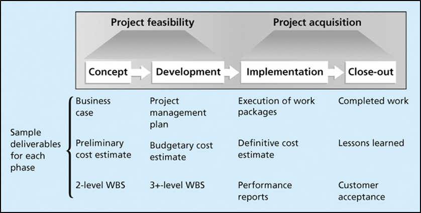
Click for a text description of figure 2-1: Phases of the Project Life Cycle
The figure explains the main phases typically involved in the start-up, planning, and execution of all projects. These phases are shown as four boxes with connecting arrows pointing from left to right. Two of the phases, Concept, and Development establish the feasibility of the project and the foundation for execution. Above these two phase boxes is a text label, "Project Feasibility". Below each Phase box is a list of "sample deliverables". Types of deliverables for the Concept Phase include a "business case", "preliminary cost estimate", and an initial plan--typically a 2-level Work Breakdown Structure (WBS). The "Development Phase" includes a "project management plan", "budget estimate", and a more detailed WBS (3-level). To the right of the first two phase boxes are boxes for the Implementation and Close-out phases. Above these two phase boxes is a text label, "Project Acquisition." Deliverables associated with the "Implementation Phase" typically include completion of work and performance reports. The Close-out Phase includes the confirmation of all completed work (consistent with the plan) and a "Lessons-Learned" evaluation--a compilation of good and bad project practices and results that may be used to improve future project management.
The concept and development phases look at the project feasibility. The concept phase involves a rough assessment of the project, why it may be beneficial, and preliminary cost estimates. Projects that require too large an investment in time, or are inappropriate or too expensive for an organization, should be disregarded or culled at this time. In this class, we will move through the concept phase in Lesson 3 and create a summary document called a project charter.
The development phase fleshes out all aspects of the project charter, including what the project will accomplish, who will do the work, how much time it will take, and what it will cost. At the end of the development phase, no actual work has been done on the project, although all the planning is complete. In this class, we will move through the development phase in Lessons 4-10 and create a summary document called a project plan.
The implementation and close-out phases focus on doing and delivering the work for the project. In the implementation phase, the team creates those things outlined in the project plan, called the deliverables. Implementation also involves controlling any changes to the plan, including changes in budget, timing, or deliverables. In the close-out phase, the work is complete and delivered. In this phase, the customer may be queried regarding the acceptability and quality of the project. In this class, we will not have time to work a project through the implementation and close-out phases.
Read Croswell, Chapter 2 for a discussion of project phases in typical GIS development projects.
Project Management Process Groups
Project Management Process Groups
Describing a project by its life cycle is a useful analogy, but it lacks important detail. Namely, it doesn't describe the processes necessary to move from one phase to another. We will group these processes into five categories, all of which can and should occur in each phase of a project's life. These processes, as defined by the PMI and illustrated in Figure 2-1 are:
- Initiating
- Planning
- Executing
- Controlling
- Closing
Initiating processes are actions that begin a phase of a project. For example, most organizations will not begin work on a project for another organization until a formal contract is signed. In this case, moving from the development phase to the implementation phase is dependent on an initiating process. Planning processes ensure projects align with an organization's mission. For example, an organization may plan an outcome assessment at the close-out phase of a project. Executing processes coordinate people, resources, and activities to accomplish work (following tasks in the project plan and completing project deliverables). This Executing process group is the place where work actually gets done--all of the other process groups support project execution activities. Controlling processes are designed to ensure project success. An extension of a deadline at no cost to the client would be an example of a controlling process. Finally, Closing processes end a phase or project. Creating an archive of a GIS project is an example of a closing process. In addition, the PMI suggests documenting "lessons learned" to serve as a project knowledge base for future projects. A "Lessons Learned" knowledge base is a summary of work, practices, methods compiled from past projects or external sources that worked well or should be avoided.
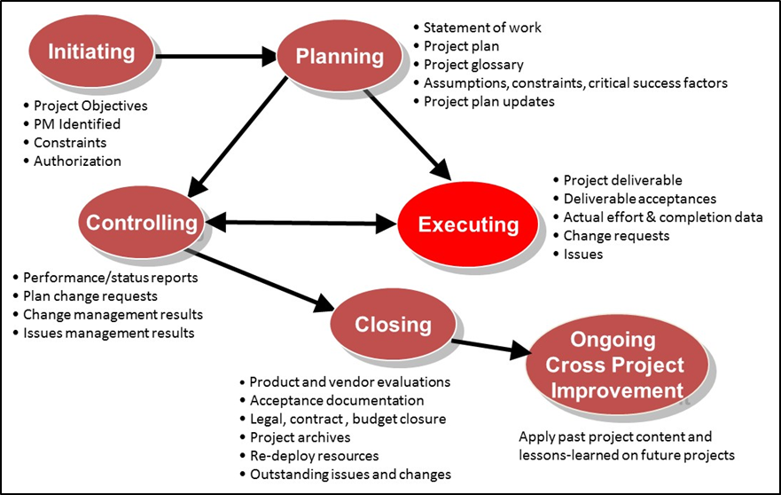
Click for a text description of figure 2-1: Project management process elements
Figure 2-1 explains “project management process elements” as defined by the Project Management Institute (PMI). It shows each of the six process elements as shaded oval shapes, with connecting arrows showing the relationships among the process elements. Each of the process element oval shapes has a text list of the main activities and products for the Process Element. These PMI "process groups" are NOT meant to be used as project phases in a project work plan. They provide a perspective on activities and concerns that need to be addressed by the organization and a project manager before the project starts, during its execution, and after it is closed.
The Initiating process element, shown at the top left of the figure, contains processes such as identifying project objectives, PM, constraints, and authorizations. Initiating leads to planning, where you would identify the statement of work, project plan, project glossary, assumptions, constraints, critical success factors, and project plan updates. The Initiating process element shape has a single arrow connecting to the right with the Planning process element shape. The Planning process element lists the items: Statement of work, Project Plan, Project glossary, Assumptions, constraints and critical success factors, and Project plan updates. The Planning process element has a forked path to the Controlling process element includes the items, performance management and status reports, plan change requests, change management results, and issue management results. The Controlling process element has a double arrow line connecting to the Executing process element to the right and a single arrow connecting it to the Closing process element down and to the right. The Executing process element includes work on project deliverables, deliverable acceptance, actual effort and complete data, change requests, and project issue compilation. The Closing process element includes final product and vendor evaluations, acceptance documentation, legal closures, project archives, re-deploy resources, and outstanding issues and changes. The final phase is Ongoing Cross Project Improvement shown as an oval shape in the bottom right of the figure with a connecting line from the Closing process element. This Closing process element has the text, Apply past project content and compile lessons-learned on future projects.
The Procurement Process
The Procurement Process
Reasons and Approaches for Procurement of Products and Services
Some organizations have all the resources (skilled staff, equipment, software) necessary for completing projects on which they work. In other cases, however, it is necessary for organizations to procure products and services for a project--normally by private sector companies with a business focus on GIS. The term outsourcing is sometimes used to refer to contracted services procured for GIS projects. The types of products and services that may be needed, depends on the type of project and the nature of the organization carrying out the project. For GIS projects and programs, procurements often involve one or more of the following types of products and services:
- GIS Consulting Services: Needs Assessment, technical specifications, organizational development, strategic and implementation planning, business case development, support in procurement of GIS products and services.
- System Infrastructure and Software Specifications, Procurement, and Configuration: Preparation of technical specifications for system infrastructure; purchase of computer hardware and software licenses; set-up and configuration of hardware, software, and networks; hardware maintenance and software support services; cloud-based server resources, cloud-based GIS software and application services.
- GIS Application Development Services: Custom application design and development, application training, integration of GIS with external systems and databases.
- Database Development Products and Services: GIS database design, field inventory and data collection, aerial imagery and LiDAR collection and processing, hard copy map conversion services, data quality assurance, ongoing data maintenance services, purchase or licensing of GIS data.
- Technical Implementation and Operational Support: Training, software installation and configuration, on-site contracted staff to support GIS operations or project management.
Organizations use a variety of procedures and vehicles to specify and select GIS products and service providers. To a significant extent, the form, substance, and procedures are dictated by organization-wide policies and procedures, and, in some cases, by law. Most GIS procurements use one of the following types:
- Sole-Source Procurements: Direct selection of a vendor or consultant without pre-qualification or competitive review of offerings from others. This approach can save time, but does not allow for formal evaluation of bids and proposals from multiple companies.
- Open Competitive Procurements: Used for products and services when the evaluation of offerings from multiple companies is expected to result in the best value. Not only do competitive procurements comply with fairness policies of organizations, they also provide an opportunity for serious review of multiple proposals, approaches, and capabilities to select products and services that best suit the organization’s needs at a competitive price. Competitive procurements use a variety of specific instruments--most often a request for proposal (RFP), request for qualifications (RFQ), or request for bid (RFB). The RFP and RFQ approach allows for a competitive selection based on the quality of proposed products or services as well as the proposed price (best value selection). The RFB approach is most effectively used when there are well-defined commodity products (e.g., computer hardware) or technical services and focuses on lowest price proposals for company selection. Other competitive purchase vehicles, similar to the RFP, RFQ, and RFB approach used by some organizations, include the expression of interest or EOI (similar to RFQ), invitation to bid or ITB (similar to RFB), and a formal tender (similar to RFP).
- Selection from a pre-qualified pool of providers (or price contract): This approach allows selection of a provider of a product or service from a pre-qualified pool of companies. This pool is the result of a previous competitive selection based on a qualification process. The result is a schedule of products and services, corresponding prices, and a set of companies which have agreed to provide the products and services and the specified prices. This procurement vehicle is best suited to specifically defined commodities and services and is less appropriate for procurement of custom services. The best example is the U.S. Federal government establishment of General Services Administration (GSA) "purchase schedules" also known as "multiple award schedules" (MAS).
- Extension or amendment of an existing contract: A contractor or vendor is awarded new work or provision of additional products through an existing contract. Usually, this requires a formal amendment to the existing contract. This is an administratively expedient approach, providing that procurement rules in an organization allow. This approach eliminates the significant time in selection and contracting and, if the contractor has performed well under the existing contract, gives reasonable assurance of future performance.
The specific rules and processes governing each of these types of procurements vary among organizations. Normally, the organization’s purchasing department controls and documents them. Competitive procurements and price contract selections are common for public sector organizations (especially for products and services that exceed a certain maximum price level). Private firms may use any of the procurement vehicles and typically make more frequent use of sole source procurements since this is typically more administratively expedient and company policies do not mandate the use of competitive procurement approaches. GIS project managers should gain familiarity with their organization's procurement policies and follow these policies closely. Lack of adherence to policies could result in protests (by bidders) and possible cancelation of the procurement.
The review of submitted proposals and bids, in response to these formal procurement solicitations, should follow a clear, documented process of evaluation and scoring that includes technical merit and proposed price. The end result is a formal agreement or contract defining the terms of product and service provision.
Refer to Croswell Section 5.2 for more information about procurement approach and procurement management.
Contracting
A contract or service agreement is a legally binding document that establishes terms for the provision of products or services from a contractor or vendor. In the public sector, if your organization supplies services to another organization for a particular project, you generally sign a different type of contract, like a memorandum of agreement (MOA) or an interagency agreement. Some organizations have designated personnel to write and review such contracts; if you are consulting on your own, it is likely up to you to understand the contract. Contracts for GIS products and services typically include the following:
- identification of the client or purchaser and the party providing the products and services
- time period for which the contract is valid, with terms covering grounds for contract extension or termination
- for services, a clear definition of the scope, deliverables, quality criteria, and performance measures
- for products (e.g., computer hardware, data products, etc.), an identification of applicable make and model numbers and data deliverable content
- role and responsibilities for all parties
- standard legal terms and conditions (sometimes referred to informally as "boiler plate" required by the organization
Most organizations have personnel with responsibilities for contract preparation and negotiation to ensure compliance with all applicable policies, laws, and regulations. As a GIS project or program manager, you will need to become familiar with your organization's procurement rules, policies, and standard terms for procurement documents and contracts. From a financial perspective, contracts include terms for invoicing and payment, which normally use one of the following methods:
- fixed-price contract
- cost-reimbursable contract
- time and expense contract
- unit price contract
Fixed-price contracts define a price for specific products, deliverables, or services. This is a common approach for services from GIS database contractors, in which data deliverables (e.g., aerial acquisition and processing of orthoimagery) are provided for an agreed monetary amount. Cost-reimbursable contracts are designed to pay suppliers for costs that can be traced back to the project in ways that are both cost-effective and cost ineffective. These are called direct and indirect costs, respectively, and we will talk more about these in Lesson 6. Time and expense contracts establish invoicing and payment for an itemized reporting of labor time and rates (in person-hours or person-days) for project personnel and for expenses directly connected with project work (e.g., travel expenses). Time and expense contracts often have a price cap which cannot be exceeded without a formal contract amendment. Unit price contracts define a price the supplier will be paid for a given unit of service. In a contract to provide individual GIS training courses for all new workers in an organization over a fixed period of time, a unit price contract may be most appropriate.
Note: When companies cite a "billable rate" as an hourly or daily dollar amount for project personnel, it is most often presented as a "burdened rate" meaning that it covers the cost of the employee (salary and benefits) as well as company overhead and profit.
Read Croswell, 5.2 for more information about contracting and contract management for GIS projects.
Assignment #1-Project Fit to Organization (Part 2)
Assignment #1-Project Fit to Organization (Part 2)
Assignment #1 (Part 2) Overview
Submittal Timing: Assignment 1 (Parts 1 and 2). See Canvas Calendar
Target Word Count: About 1800-2500 words total for Parts 1 & 2
Total Points: 60 points - see rubric for specific details
For Assignment #1, as described in Lesson 1, you will write a brief report on a GIS project done by or for an organization and your assessment of its fit to the organization. For Part 1, you have already documented and described a project undertaken by an organization. For Part 2, you will summarize the organization’s mission and how the described project supports the organization’s mission, strategic goals, and its work responsibilities.
The Assignment #1 submission includes both Part 1 and Part 2.
-
Organization's Mission and Business
For Part 2, the first step is to state the organization's mission, strategic goals, and any other summary information about the organization’s business and work responsibilities that help to create a context for the purpose of the GIS project you selected in Part 1 (see Lesson 1).
Most public sector organizations and private sector companies have a mission statement, goals, and other information about the organization’s work responsibilities posted to their website or in a strategic plan document. Sometimes this can be quite lengthy so, if it is, you should summarize to capture the essential elements of the mission and goals relating to your selected project. If the project is being carried out by a specific department or division within a larger organization, it is best just to focus on the mission and goals about that department or division (not the overall organization). If you chose a project that's to be carried out by a contractor for a client organization (e.g., acquisition and processing of aerial imagery for a local government), the mission and “project fit” that you will describe in Part 2 should focus on the client organization (i.e., the local government), not the contractor. In other words, relate to the organization that will be using the products and deliverables from the project (even if the work is done by a contractor). Ideally, your Part 1 project selection is for an organization with a clearly stated mission and goals, but if not, this is an opportunity to create a mission and goals based on what you know about the organization's business and purpose. It is OK for you to make some assumptions, "embellish", and elaborate on actual information about the organization in order to meet the requirements for this assignment.
-
How the project supports the mission/business of the organization
The second step for Part 2 is to briefly describe how the GIS project supports the organization’s mission, goals, and work responsibilities. To do this, focus on the objectives, results, and deliverables from the project. Keep this brief. For instance, if the project involved a field data collection and GIS database development of fire hydrants for a local fire department, you would describe how this data supports hydrant testing and maintenance, planning for new hydrant installation or replacement, and, at a high-level, provides support for public safety by ensuring effective response to fire events. Very often, GIS projects relate directly to detailed operational requirements as well as higher-level aspects of the organization’s mission.
-
Role of procurement of outside products or services
The final step of Part 2 is to briefly comment on the role of procurement of products or outside services on the project (if applicable). This simply means an identification of the selection, acquisition, and use of any outside products or services for the project and the aspects of project work that the procurements support. This could include purchase of GIS or other software, computer hardware, or use of contracted services for some part (or all) of the project. Briefly identify the procurements and the vehicle (e.g., RFP) or approach used to select and approve vendors/contractors for these procurements. If there are no procurements for the project, state that this is the case.
You will then combine the material from the topics described above with the project description information from Part 1 for your Assignment 1 submittal to discuss the fit of a project to an organization. The Assignment 1 (including Parts 1 and 2) submittal should be about 1800 to 2500 words total for Parts 1 & 2.
_______________________________________________________
As in all written assignments, you should include a Cover page with prominent title and all necessary information identifying the course, assignment, author, and date. The main title of the document should be "PROJECT FIT TO ORGANZATION". The Cover Page should also reference to the project name and organization. At the bottom of the Cover Page, include the following information: a) course number and name, b) assignment number and name, c) your name, d) submittal date. Also number the pages and include a Table of Contents whihc can be automatically generated by your word processing if you define headings and subheadings (e.g., See Style settings in Microsoft Word). Your submitted assignment should be formatted as specified in the Format Quality of this assignment’s rubric below to earn maximum points. As you prepare this assignment, START WITH AN OUTLINE, with sections and subsections that cover the topics in Part 1 and Part 2. We recommend that you use the Outline/Heading feature of your word processing software in document preparation. It is expected that you will organize the document into numbered and named sections. It is best practice today, for technical and management documents, to use a "decimal" outline numbering scheme (1., 1.1, etc.) as opposed to the older Roman numeral numbering approach.
Submitting the Assignment and Grading
Submit both Part 1 and Part 2 of Assignment #1 during Week 2 (see course calendar).
This assignment is worth 60 points. The grading approach is explained in the rubric table below.
The instructor may deduct points if the Assignment is turned in late, unless a late submittal has been approved by the Instructor prior to the Assignment submittal date.
| Grading Category | Basis for Scoring | Total Possible Points |
Point Award Explanation |
|---|---|---|---|
| A. Inclusion of Required Content |
|
18 |
|
| B. Overall Document Organization |
|
12 |
|
| C. Quality/Clarity of Writing | Writing quality and clarity effectively uses words and sentences to convey meaning to the reader including the following:
|
18 |
|
| D. Format Quality | Well-formatted document helps convey content and meaning to the reading. Important format parameters include:
|
12 |
|