Lesson 9: Case Study: Hurricane Katrina
9.1 Overview
This lesson will conclude our three-week examination of emergency preparedness and disaster management. This third lesson is a historical case study of Hurricane Katrina. Your deliverable this week is a forum with two questions and an assignment. As part of your deliverable, you will research a contemporary disaster and provide a short PowerPoint presentation (see 9.6) part of which will show how the government disaster response efforts have improved (or not) since Katrina.
Lesson Objectives
At the end of this lesson, you will be able to:
- discuss and critique the use of intelligence and especially geospatial intelligence in the planning for, and response to, Hurricane Katrina;
- synthesize the ideas of previous lessons to critique the role of intelligence and especially geospatial intelligence in relation to Hurricane Katrina;
- discuss the social justice implications for geospatial intelligence applications in Hurricane Katrina;
- compare the government response to Katrina with the government response to a more recent disaster;
- speculate on future applications of geospatial intelligence for disaster management.
Questions?
If you have any questions now or at any point during this week, please feel free to post them to the GEOG 882 in Canvas.
9.2 Checklist
Lesson 9 will take us one week to complete. Please refer to the Calendar in Canvas for specific time frames and due dates. Specific directions for the assignments below can be found within this lesson.
Complete the following steps to complete Lesson 9:
- Work through Lesson 9 in this website.
- Read:
- the Foreword, Chapter 5, and Appendix A, and scan the rest of the material in "The Federal Response to Hurricane Katrina: Lessons Learned [1]."
- the Executive Summary (6 pages) of "A Failure of Initiative [2]."If you are interested, you can access to the individual sections of the full report [3].
- the Executive Summary and scan the rest of "From Challenge to Action." [4]
- "The Worst is yet to Come: Lessons from September 11 and Hurricane Katrina. [5]" from the research paper from Donald F. Kettl of the Fels Institute of Government of the University of Pennsylvania.
- "The Geography of Social Vulnerability: Race, Class, and Catastrophe [6]" from the essay by Dr. Cutter and then examine the Understanding Katrina website [7] and peruse any other essays that interest you.
- the Executive Summary and scan the rest of "In the Wake of the Storm: Environment, Disaster, and Race after Katrina." [8]
- "Partnerships: FEMA Looks to NGA for Disaster Help" [9] from Shawna Wolin's article (page 29-30) in the July-August 2006 issue in the NGA Pathfinder magazine.
- "Results and Recommendations on the Role of Airborne and Commercial Satellite Imagery in Emergency Response [10]" from the ASPRS report.
- "The Red Pill [11]" by Kathleen Tierney.
- "NGA Makes the Difference: Hurricanes and Technology Challenges [12]" from the September-October 2005 issue of the NGA Pathfinder magazine.
- Watch Frontline's "The Storm" [13] and watch the entire video.
- Participate in the three-part "Lesson 9 - GRADED Discussion Forum (#3)."
- Create a PowerPoint comparing the government response to Katrina with the government response to a more recent disaster and upload it to one of the three discussion forums.
9.3 Hurricane Katrina
Background on Katrina and its Aftermath
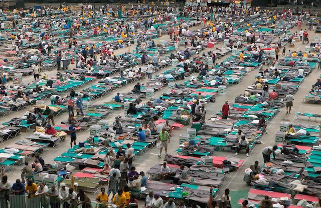
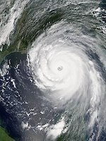
Hurricane Katrina formed on 23 August 2005 and dissipated on 31 August 2005. In her nine day life, Katrina would wreak devastation across several states and destroy the city of New Orleans. Overall, Katrina would take at least 1836 lives and cause over $80 billion in damage, making it the most expensive disaster in US history. The after effects of Katrina continue to this day. The general perception is that the US disaster preparedness and response system, including all levels of government and disaster non-governmental organizations, failed in its initial response to Katrina. Thus, governments and NGOs at all levels continue to study Katrina to prevent future debacles. The political fallout from Katrina also continues as New Orleans attempts to rebuild with a population that as of 2023, is less that 80% of the pre-Katrina number.
Optional Reading
Wikipedia article on Hurricane Katrina [15]
Hurricane Katrina. (2023, Nov. 16, 2023) https://en.wikipedia.org/wiki/Hurricane_Katrina [16]
Frontline: "The Storm"
We begin our case study of Hurricane Katrina with a Frontline documentary available from the PBS website via streaming video. As an educator, I personally love Frontline as I believe it is fair, balanced, well researched, and hard hitting beyond anything on commercial television. I also love Frontline because they have over sixty of their best episodes available as streaming video for free.
Required Viewing
Access Frontline's "The Storm [13]" and watch the entire video. I also encourage you to review the website [17] for this episode and examine the Interviews, Analysis, and Timeline sections for further information. The link to the video can also be accessed from the Lesson 9 Checklist [18].
The Federal Response
President George Bush suffered severe criticism for the federal response to Hurricane Katrina. He charged his Assistant for Homeland Security and Counter-Terrorism to oversee a study that determined what went right and wrong, and what changes should be made to prepare for the next Katrina.
Required Reading
Read the Foreword, Chapter 5, and Appendix A, and scan the rest of the material in "The Federal Response to Hurricane Katrina: Lessons Learned." The reading can be accessed from the Lesson 9 Checklist. [18]
Required Reading
Read the Executive Summary (6 pages) of "A Failure of Initiative." If you are interested, you can access to the individual sections of the full report. The reading can be can be accessed from the Lesson 9 Checklist [18].
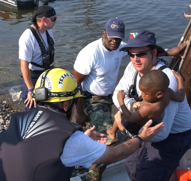
NGO Responses to Katrina
Non-Governmental Organizations play a crucial role in disaster relief. Some NGOs spring up shortly after a major disaster as groups of concerned citizens who want to help their neighbors. Other NGOs are enduring charitable organizations such as the Salvation Army that rapidly bring resources to bear in an emergency. The premier NGO for disaster relief in the United States is the American Red Cross.
The Red Cross Movement consists of the International Commission of the Red Cross/Red Crescent (ICRC), and The International Federation of the Red Cross/Red Crescent (IFRC). The ICRC based in Geneva, Switzerland is mandated by international treaty to support several functions during armed conflict including emergency humanitarian relief, protection of human rights, detainee visits, etc. The ICRC is funded by contributions by all the signatory governments to the Geneva Conventions and has a one billion Swiss Frank budget per year. The IFRC is the umbrella organization for the national Red Cross movements. Each national movement has its own charter and often has a relationship and charter from their national government to provide certain services and capabilities.
Mission Statement
The American Red Cross prevents and alleviates human suffering in the face of emergencies by mobilizing the power of volunteers and the generosity of donors.
Fundamental Principles of the International Red Cross and Red Crescent Movement
- Humanity
The International Red Cross and Red Crescent Movement, born of a desire to bring assistance without discrimination to the wounded on the battlefield, endeavours, in its international and national capacity, to prevent and alleviate human suffering wherever it may be found. Its purpose is to protect life and health and to ensure respect for the human being. It promotes mutual understanding, friendship, cooperation and lasting peace amongst all peoples. The principle of humanity expresses what the Movement places beyond anything else: the need to act in order to prevent and alleviate human suffering. Respect for human dignity and helping people—regardless of who and where they are—is paramount to everything we do.
- Impartiality
It makes no discrimination as to nationality, race, religious beliefs, class or political opinions. It endeavours to relieve the suffering of individuals, being guided solely by their needs, and to give priority to the most urgent cases of distress. Non-discrimination is one of the most important aspects of protecting human beings in human rights law, humanitarian law and refugee law. Sadly, there are many factors for which people are discriminated against. The text of this principle does not include an exhaustive list of factors. But it makes clear that no group of people will be denied services or receive preferential treatment based on anything other than their needs.
Only by acting with impartiality can we ensure the Movement is trusted by all people to assist and protect them. We therefore have systems in place to ensure we deliver our support based on people’s needs alone and prioritize the most vulnerable at all times.
- Neutrality
In order to continue to enjoy the confidence of all, the Movement may not take sides in hostilities or engage at any time in controversies of a political, racial, religious or ideological nature. The Movement must not take sides, or be regarded as doing so, either in its speech or actions at any time or place. Neutrality ensures the Movement has the confidence of all and can provide humanitarian support to all. Embodying the principle of neutrality at all times ensures the Movement can provide medical assistance to civilians and wounded or detained fighters during hostilities without being perceived as interfering in conflict. It is of the utmost importance that all parties in a conflict understand and respect the humanitarian role of a National Society.
- Independence
The Movement is independent. The National Societies, while auxiliaries in the humanitarian services of their governments and subject to the laws of their respective countries, must always maintain their autonomy so that they may be able at all times to act in accordance with the principles of the Movement. The principle of independence means that the Movement must resist any interference—be it political, ideological or economic—capable of diverting it from embodying the principles of humanity, impartiality and neutrality. It is only by being truly independent that the Movement can respect these principles. Independence not only relates to the relationship between National Societies and States, but also between National Societies and any other forms of power or influence, such as religions, political parties, companies and so on.
- Voluntary Service
It is a voluntary relief movement not prompted in any manner by desire for gain. The principle of voluntary service represents the common motivation uniting all those working within the Movement: a desire to help others. It is both a source of inspiration and a statement of solidarity. Whether members volunteer without pay or with some form of acknowledgement or even modest remuneration, it is not inspired by desire for financial gain but by individual commitment and devotion to the humanitarian purpose. This is freely chosen and accepted as part of the service the Movement provides to the community.
- Unity
There can be only one Red Cross or one Red Crescent Society in any one country. It must be open to all. It must carry on its humanitarian work throughout its territory. Having only one Red Cross or Red Crescent Society in any given country ensures it can work efficiently. It avoids any risk of confusion in the public mind and means all people and communities are represented by one organization. A National Society must be active in all parts of the country so that even the hardest-to-reach communities can benefit from support when needed. This doesn’t mean that the level of activities must always be the same country-wide—the principle of impartiality may justify that certain areas need more support where the needs are greater. Similarly, National Societies must not discriminate when recruiting volunteers. They must ensure their membership includes a broad spectrum of people across the population so that humanitarian assistance is delivered to all people, by all people.
- Universality
The International Red Cross and Red Crescent Movement, in which all Societies have equal status and share equal responsibilities and duties in helping each other, is worldwide. The universality of suffering requires a universal response. It is one of the Movement’s great strengths that we are present in virtually every country in the world through our 191 member National Societies. This principle also means that National Societies have a collective responsibility to support each other’s development and to work together in partnership and solidarity during disasters, for the benefit of all. When it comes to decision-making within the Movement, the principle of universality ensures that all National Societies have an equal vote during Statutory Meetings irrespective of their size or wealth.
The American Red Cross plays a key role in American disaster preparedness and response. While ARC volunteers made significant contributions during Katrina, the organization acknowledged shortcomings within its operations. In an effort to improve and be prepared for future Katrinas, the ARC published "From Challenge to Action: American Red Cross Actions To Improve and Enhance Its Disaster Response and Related Capabilities For the 2006 Hurricane Season and Beyond [19]" in June 2006.
Required Reading
Read the Executive Summary and scan the rest of "From Challenge to Action" for a sense of the challenges Katrina posed for a major American NGO and the ARC's plans for change. The reading can be accessed from the Lesson 9 Checklist [18].
The Worst is yet to Come
Katrina was a disaster, but some would say the catastrophe was our response to the storm. The terrorist attacks of September 11, 2001 and Katrina caused serious consideration of the American ability to deal with the consequences of a serious natural or technological disaster. Political leaders, scholars, and citizens ask the legitimate question of what will America do as a nation to be prepared for the next Katrina, nuclear accident, or major terrorist attack?
Required Reading
Read the following research paper from Donald F. Kettl of the Fels Institute of Government of the University of Pennsylvania, entitled "The Worst is yet to Come: Lessons from September 11 and Hurricane Katrina." The reading can be accessed from the Lesson 9 Checklist [18].
9.4 Social Justice Issues
As we learned in a previous lesson, people experience risk and vulnerability to hazards differently. Quite often this is based on characteristics of social class, race, gender, and age. Hurricane Katrina brought this home to the American people as never seen before. The news media played a major role in highlighting the inequities and social justice issues Katrina made evident.
My experience is that many GIScience students are unaware of the social justice implications of GIS&T. These students often times see the technology as a neutral tool that supports good decision making. This impression is wrong. Every time a geospatial analyst makes a decision about what data or technique to use, there are potential social justice issues. At best, the non-critical geospatial analysts may make choices without thinking about the implications for traditionally disadvantaged groups. At worst, the analysts may make conscious choices to use data sets and methods that will discriminate against certain groups to the benefit of others for reasons of profit, power, influence, or favor with policy makers. My challenge to you is to recognize the implications in your choice of data, methods, and your analytical outcomes in regards to social justice issues. The technology may be value free and neutral, but the humans behind the technology are not.
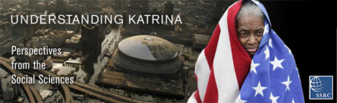
Susan Cutter on Hurricane Katrina
The Social Science Research Council [20] responded to Hurricane Katrina with an online project called "Understanding Katrina: Perspectives from the Social Sciences." As the SSRC puts it:
As analyses and "spin" of the Katrina crisis grow, we confront the sort of public issue to which a social science response is urgently needed. Accordingly, the SSRC has organized this forum addressing the implications of the tragedy that extend beyond "natural disaster," "engineering failures," "cronyism" or other categories of interpretation that do not directly examine the underlying issues-political, social and economic-laid bare by the events surrounding Katrina.
The SSRC believes the underlying failures of Katrina go far deeper than weather, bad levees, or good old boy government. The social science scholars involved seek to understand the deeper implications of underlying issues.
Dr. Susan Cutter, whom you will recall from the previous lesson, contributed the Understanding Katrina project with the essay "The Geography of Social Vulnerability: Race, Class, and Catastrophe [6]". See reading below.
Required Reading
Read Dr. Cutter's essay on "The Geography of Social Vulnerability: Race, Class, and Catastrophe [21]," and then examine the Understanding Katrina website [22] and peruse any other essays that interest you. The links can be accessed from the Lesson 9 Checklist [18].
In the Wake of the Storm
The Russell Sage Foundation [23] was established in 1907 by Mrs. Margaret Olivia Sage to foster the improvement of social and living conditions in the US. The foundation does this by fostering the development and dissemination of knowledge about US political, social, and economic problems. In the wake of Katrina, the foundation sponsored research on the social justice implications of Katrina. The resulting report entitled "In the Wake of the Storm: Environment, Disaster, and Race after Katrina [24]" is a major contribution in understanding the social justice issues related to hazards, risks, and vulnerability.
Required Reading
Read the Executive Summary and scan the rest of "In the Wake of the Storm: Environment, Disaster, and Race after Katrina." The reading can be accessed from the Lesson 9 Checklist [18].
9.5 Geospatial Intelligence and Katrina
The NGA and Katrina
Government and private sector geospatial intelligence practitioners have good reason to be proud of the contribution of GIS&T to Katrina response and recovery efforts. The National Geospatial-Intelligence Agency was mentioned in the "Federal Response to Hurricane Katrina" report in Appendix B on "What Went Right":
The National Geospatial-Intelligence Agency (NGA) started collecting key infrastructure-related information (i.e. on airports, hospitals, police stations, emergency operations centers, highways, schools, etc.) well in advance of landfall and got this information into the hands of Federal, State, and local first responders in the affected region. As the storm was tracked, NGA pre-deployed analysts and mobile systems to the affected areas that provided expertise and information on the ground and facilitated the delivery of additional information from NGA offices elsewhere. Because they had assets in place and focused on the region, NGA provided the first comprehensive overview of the damage resulting from the hurricane and flood. NGA merged imagery with other information, creating hundreds of intelligence products per day that could be used and applied by response professionals to aid in decision-making. NGA assessments were multi-dimensional, timely, relevant, and continuous. They addressed many issues, including but not limited to: recovery planning and operations, transportation infrastructure, critical and catastrophic damage, dike stability and breaches, industry damage, and hazard spills. The NGA World Wide Navigational Warning Service also provided navigation information to the U.S. Navy, Merchant Marine, and Coast Guard, and relayed messages from the National Weather Service to people at sea. NGA also aided in the location and recovery of oil platforms. The imagery activities of NGA were essential to the restoration of critical infrastructure." See Also: U.S. National Geospatial Intelligence Agency, "Geospatial Intelligence Aids Hurricane Recovery Efforts," news release, September 7, 2005.
NGA is proud of its contribution to hurricane preparedness and relief efforts.
Required Reading
Read the September-October 2005 issue of the NGA Pathfinder magazine. The issue title is "NGA Makes the Difference: Hurricanes and Technology Challenges." The issue can be accessed from the Lesson 9 Checklist [18].
Many of my students in this course are geospatial analysts for NGA or the military. Shawna Wolin was a student in the first offering of this class, and she is the co-author of an article in the July-August 2006 NGA Pathfinder magazine.
Required Reading
Read Shawna Wolin's article "Partnerships: FEMA Looks to NGA for Disaster Help" (page 29-30) in the July-August 2006 issue of the NGA Pathfinder magazine for insight on how a classmate might be directly involved in the issues we study. The reading can be accessed from the Lesson 9 Checklist [18].
A Critical Look
My mission in teaching this course is to teach you to use higher order thinking skills and, most importantly, to be CRITICAL THINKERS. So let me tell you a story about trying to craft this lesson. The Penn State GEOINT faculty paid a visit to Washington to talk to key players in the geospatial intelligence business for national security, disaster preparedness, and international disaster relief. This included visiting the NGA College at Fort Belvoir and FEMA Headquarters in Washington, DC. To make a long story short, all the agency representatives thought this course and program were a great idea. They especially liked the critical thinking component of this course. However, no one wanted to take any risk by providing any unclassified case studies that were self-critical of their own operations. Perhaps these case studies do not exist or they are classified and unavailable. What is available from NGA is public affairs material like the Pathfinder magazine. Now, do not take me wrong. I have some background with the world of secrets and I understand protecting sensitive information and sources and methods. However, my experience and personal opinion is that too often secrecy is used to prevent true critical analysis, which is essential to process and produce improvement.
You just read several articles on NGA contributions during Katrina. Let me tell you about an interview with a key geospatial player from FEMA and that person's insights on NGA support for FEMA during Hurricane Katrina. (As the person did not respond to a request to provide written notes or participate in our forum, their privacy will be respected, and they will remain unnamed.)
The FEMA geospatial analysts had numerous requirements for imagery, data, and processed geospatial analytical products. NGA was on the scene and highly motivated to help. The problem was one of culture and orientation.
A historical conversation from a FEMA responder to Hurricane Katrina and some of the issues they noted:
- There were issues about data sharing due to the classified nature of some of the collection systems. Fortunately, commercial imagery solved many of these problems. However, the culture of secrecy hinders interagency coordination between defense oriented agencies such as NGA, and other federal, state, local, and NGO agencies who do not share that culture nor have the required clearances.
- NGA did not understand FEMA procedures and processes and thus did not always provide usable products. For example, FEMA must do damage assessments at various scales to include house by house assessments. These assessments drive the amount of relief funds that FEMA provides to individual homeowners. Katrina caused devastation on a scale that overwhelmed traditional ground damage assessment survey methods. Geospatial approaches seemed a natural solution to conduct damage assessment on such destruction. NGA used remote sensing products processed with GIS to provide damage assessment maps. Unfortunately, the map data did not suit the needs of FEMA and was unusable. The issue was educating the NGA analysts on FEMA customer needs, and having NGA be nimble enough to understand and craft technical solutions capable of creating useful products in a timely fashion.
- FEMA is a civilian agency that has been in crisis for over a decade. NGA is a Department of Defense combat support agency, as well as a member of the national intelligence community. There are cultural gaps between NGA (DOD really) and FEMA that get in the way of truly seamless interagency coordination.
(Note to students: consider for your case study in the related Canvas Discussion forum- Fema was in crisis at the time- is this still the case? Or how have things changed?)
Now, for those of you at NGA who may have worked Katrina and might be fuming, do not take the above observations as a criticism of you or NGA. My point is that to get better, you have to be willing to take a hard and candid look at what went wrong, so that you can get better for the next time. Those of us outside the federal agencies hope they are doing this internally, because they certainly are not doing it in view of the public. And that is a shame because there are citizens and scholars who might well have an outside perspective useful to the discussion.
Now consider the lessons learned from members of the American Society of Photogrammetry and Remote Sensing (ASPRS) who were involved in Katrina. Read the report below and then look over the resources on the ASPRS website [25]. The presentations are especially interesting. Andrew MacInnes of Plaquemines Parrish, LA is a graduate of the Penn State online masters in GIScience Program. His presentation on "Airborne and Satellite Imagery Use and Collection for Katrina and Rita is very interesting, and it has some amazing images.
Required Reading
Read the ASPRS report "Results and Recommendations on the Role of Airborne and Commercial Satellite Imagery in Emergency Response". The report can be accessed from the Lesson 9 Checklist [18].
As a final reading, consider this most interesting essay from the SSRC Understanding Katrina Project. Note the author's academic background and affiliation. Consider the implications of her insights for both geospatial intelligence and the broader issues we have been studying.
Required Reading
Read "The Red Pill" by Kathleen Tierney. The reading can be accessed from the Lesson 9 Checklist [18].
Reference:
National Geospatial Intelligence Agency (n.d.). Geospatial Intelligence Aids Hurricane Recovery Efforts. Retrieved Nov. 16, 2023 from https://www.fgdc.gov/organization/steering-committee/meeting-minutes/oct... [26].
9.6 Summary and Final Tasks
Summary
This lesson was a case study of Hurricane Katrina, and it concludes our three-lesson section on domestic disaster preparedness. In this section of the course, we examined the fundamentals of emergency management, including the National Response Plan and the National Incident Management System. We also examined the very important and often ignored issue of social justice in disaster preparedness and response, as well as the contribution of GIS&T to emergency management. This final case study of Hurricane Katrina allowed you to:
- discuss and critique the use of intelligence and especially geospatial intelligence in the planning for, and response to, Hurricane Katrina;
- synthesize the ideas of previous lessons to critique the role of intelligence and especially geo-spatial intelligence in relation to Hurricane Katrina;
- discuss the social justice implications for geospatial intelligence applications in Hurricane Katrina;
- compare the government response to Katrina with the government response to a more recent disaster;
- speculate on future applications of geospatial intelligence for disaster management.
Final Tasks
Deliverable: Lesson 9 - GRADED Discussion Forum (#3)
Return to Lesson 9 in Canvas. Look for the Lesson 9 - GRADED Discussion Forum (#3), where you will find the three required questions and an optional question for this assignment. The minimum requirement is that each of you post one primary response to each of my questions and comment on at least three of your classmates' posts. (Note: for the second discussion forum question, you are required to create a PowerPoint comparing the government response to Katrina with the government response to a more recent disaster and upload it to the corresponding discussion forum.)
Please post your primary response to the questions by Sunday evening to allow time for everyone to post comments by Tuesday night.
Before you move on to Lesson 10, double-check the Lesson 9 Checklist [18] to make sure you have completed all of the required activities for this lesson.
Looking Ahead
Congratulations!! You have completed lessons 1 through 9 and are now ready to move on to the final lesson - Lesson 10 - Trends in Geospatial Intelligence.
For the final lesson, we will explore some other applications of geospatial intelligence and reflect on the future of the field. I will also ask that you complete two course surveys that will provide feedback to PSU and to me regarding the course content, delivery, graded requirements, etc. This feedback is essential to improving the course, so I appreciate your candid responses.
See you at the Critique!