Lesson 8 Civilian and Commercial Applications of the Unmanned Aerial System
Lesson 8 Introduction
Welcome to Lesson 8! In this lesson, you will become familiar with the different applications that the UAS is utilized for. The list of commercial and civilian applications is increasing by the day. It is difficult, if it is not impossible, to nail down such a list. The low cost and easy deployment of the UAS encouraged many people to utilize the unmanned aircraft to replace manned aircraft for their activities. Users are discovering new applications every day; however, we will only cover in this lesson the most obvious one. We will not cover the military application, as it is obvious, but we will consider, for the purpose of this lesson, the security and surveillance use of UAS as a civilian/commercial application since some of such services are offered commercially. Much of the commercial and scientific use of UAS that concerns us is in the field of geospatial data acquisition for remote sensing activities. The term “geospatial data” refers to any dataset that is referenced spatially (i.e., geolocated or geo-referenced) with known coordinates systems and datum. I expect from you in this lesson to read chapter 6 of the textbook Introduction to Unmanned Aircraft Systems and several external readings I will point out in the lesson notes.
Lesson Objectives
At the successful completion of this lesson, you should be able to:
- recognize different applications of the UAS for civilian use;
- understand how the UAS data is used for different applications;
- compose a list of additional applications that can be served by UAS.
Lesson Readings
- Chapter 4 (UAS Sensing: Theory and Practice) of textbook 1, 2nd edition: Barnhart, et al., Introduction to Unmanned Aircraft Systems
- Chapter 20 of textbook 3: Wolf, et al., Elements of Photogrammetry with Applications in GIS
- Gahran, A. “Fighting fire with data, spacecraft, drones [1]"
- Chao, H., et al., "AggieAir: Towards Low-cost Cooperative Multispectral Remote Sensing Using Small Unmanned Aircraft Systems [2]"
- Read the dronenodes.com article Commercial Drone Applications On The Rise | Enerprise UAV Solutions | 2018 [3]
- Read the lecture slides on Digital Image Classification [4]
Lesson Activities
- Watch the webinar: " Applying Drones to Surveying and Engineering Projects Today. [5]"
- Complete Lesson 8 Quiz.
- Submit your results for exercise 2 data processing in Pix4D.
- Submit your COA Application.
Digital Image Classification for Land Use Land Cover Assessment (LCLU)
Digital Image Classification is an information extraction process (machine or automated interpretation) that involves the application of pattern recognition theory to multispectral imagery. It analyzes spectral properties of various surface features (e.g., crops) in a multiband image and sorts spectral data into spectrally related categories by the use of predefined, numerical decision rules.
The process involves:
- Categorizing images into different surface materials or conditions
- Collection of spectral signatures for specific surface materials
- Based upon spectral response
- Assumes unique spectral signatures exist for land covers
- Trains the computer to recognize those spectral signatures
- Statistical operation
- No direct site or situation information
- Does not rely on visual interpretation
- Not necessarily more accurate or objective than visual interpretation
- Someone must decide the classes and whether signatures are accurate or not
- Signature extraction
- Unsupervised classification using statistics or clustering algorithm
- Supervised classification using training sites
- Poor signatures lead to poor results
- Possibly stratify broad classes first
- Classify the imagery
- Spatial filtering for GIS compatibility
- Accuracy assessment
The process utilizes one or more of the following recognition types:
- Spectral pattern recognition: When decision rules are based on spectral radiance characteristics of the scene.
- Spatial pattern recognition: When decision rules are based on geometric characteristics of the scene (i.e. shape, size, patterns)
- Temporal pattern recognition: uses time as an aid in feature identification
- Object-oriented classification: involve combined use of both spectral and spatial recognition
Among the difficulties usually encountered with this technique are the following:
-
- Signature is not unique for given sensor characteristics
- Signature too unique
- Same cover type but with distinct differences
- Soil moisture, surface material, atmospheric conditions
- Same cover type but with distinct differences
- Mixed pixels
- Signature extension issue (over space and time)
There are two types of image classification algorithms, those are:
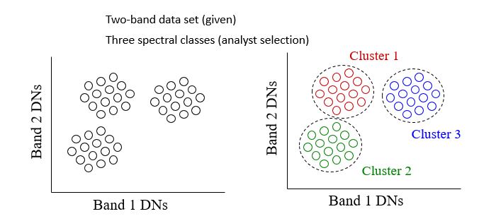
- Unsupervised Classification: uses an automatic clustering algorithm that analyzes the “unknown” pixels in the database and divide them into several spectrally distinct classes based upon their natural grouping or clusters.
In the unsupervised process, a user directs a computer software package to automatically identify and categorize pixels in an image. This is done on a purely statistical basis, though the user has control over the number of statistical classes, or clusters, to be created. With different classification algorithms, the user will also have control over statistical parameters, such as how much variation is permitted in a single class.
While there are no set rules on how many classes should be defined, a general rule of thumb is that the classes should total three times the number of final land cover categories sought. This allows for the possibility of different spectral signatures pertaining to the same land cover type (for example, if forest is sought as a class, deciduous and coniferous forests may require more than one spectral signature to accurately categorize them as forest). A number of these classes will likely represent meaningless categories or mixed pixels that may then be thrown out at a later point in the process.
Once a set of signatures has been defined, they may then be used to classify the entire image. Pixels with statistical characteristics similar to those in the signature set will be assigned the appropriate class. The resulting thematic layer has every pixel assigned a value representing the signature it was determined to be best represented by, Figure 8.1. This data set is then evaluated by the user to determine what land cover type is represented.
Processing Steps:
a - clustering or grouping
b – coloring
c – identification
Advantages and Disadvantages of Unsupervised Classification
Pros:
+ no extensive prior knowledge of the region required
+ opportunities for human error minimized
+ unique classes are recognized as distinct units
+ logistically less cumbersome
Cons:
- natural groupings do not necessarily correspond nicely with desired information classes
- no control over the menu of classes and their specific id
- spectral properties of informational classes vary over time, relationships between information and spectral classes change - make it difficult to compare unsupervised
classes from one image/date to another
- Supervised Classification: The process of using samples of known informational classes (training sets) to classify pixels of unknown identity. Identification and delineation of training areas is key to successful implementation. The basic strategy in using supervised classification is to sample areas of known cover types to determine representative spectral values of each cover type. Such samples are called training areas or training fields, Figure Training fields or spectral signatures are established from homogeneous cover type areas through:
- Map digitizing - transfer photo information to base map (use table digitizer)
- On-screen digitizing, Figure 8.2
- Seed-pixel approach
The main steps in supervised classification are the following:
- Training Class Selection
- Generation of statistical parameters to train the classification algorithm, such as:
- class means
- standard deviations
- covariance matrices
- correlation matrices
- Data Classification: Assigning each pixel of the data to one of the training class
- Evaluation and Refinement
- Documentation: Maps and tabular summaries
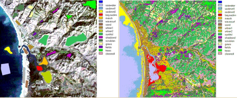
Figure 8.2 Left: Training samples Right: Supervised Classification on an image
Additional Remarks:
- With supervised classification, the process relies on user input to identify areas of specific cover types and to apply a classification algorithm that then utilizes that information to find the same cover type in other regions of the image. This process often involves having specific information on ground conditions collected through fieldwork or through high-resolution imagery/aerial photography. The sites of interest are referred to as training or calibration sites. Essentially, those portions of the image that will be used to identify other portions of the image with similar characteristics. A second set of “known” sites may be reserved for use in accuracy assessment. These are often referred to as calibration or truth sites.
- Statistics for training sites are used to define a spectral signature for specific cover types of interest. A range of supervised classification processes exist but the Maximum Likelihood classifier is one of the most common.
- Each pixel in an image is compared to the statistics compiled for the different signatures. The classification algorithm determines on a probability basis the likelihood that any given pixel should be assigned to any given class. The class providing the highest likelihood is the one that the pixel is assigned to.
Good Strategy for Supervised Classification
- Number of pixels - want to statistically characterize the spectral properties of an informational class (i.e. forest, crop, water), should have >= 100 pixels total for an informational class
- Location - geographically dispersed, boundaries away from edge/mixed pixels number of areas - depends on the number of information categories, 10 at a minimum, enough for accuracy assessment and incorporation of spectral subclasses
- Uniformity - unimodal distributions, use training areas to characterize mean, variance, covariances - sometimes not easy due to spectral variation present
Read more on Digital Image Classification [4].
To Read
To Do
- Submit materials for Digital Image Classification
The Different Application of the UAS
In this section, you will become familiar with and understand the different civilian and commercial applications of the UAS as it stands today. UAS applications that concern us the most are the remote sensing applications. Here, the UAS is replacing manned aircraft as an acquisition platform. Remote sensors such cameras and LiDAR systems are shrunk in size and weight to make them more suitable for the lightweight small UAS as was mentioned in the Payload section of Lesson 2. Remote sensing applications derived from sensors onboard a UAS are more or less similar to the applications that one can expect from a manned system. Manned aircraft can carry larger and heavier payload, which open the door for additional applications that required large sensors such as IFSAR. Reported applications for the UAS include the following:
- Remote Sensing Applications
- Precision Agriculture: Precision agriculture is the most widely used civilian application of the UAS. Farmers and the agricultural community are very optimistic about the prospect of using UAS for their daily activities. The following articles should provide you with a fairly decent idea of the topic:
- "A new era in remote sensing of crops with unmanned robots [8]"
- Drones Diversified: Krannert alumnus looks skyward, hoping unmanned vehicles will help produce an agricultural windfall [9]
- Robotic scouting: UAVs in the presentation Robotics for specialty crops: past, present and prospects [10]
- Range Land Management
- Landslides Research: Engineers are using UAS for land monitoring and management [11]. This field is also witnessing a promising future with the use of the UAS for their daily repetitive monitoring activities.
- Ocean and coastal Research
- Contaminant Spills and Pollution
- Landfill Mapping and monitoring
- Engineering and Surveying [5]
- Corridor Mapping
- Mining site mapping
- Crop and aquaculture farm monitoring
- Mineral exploration
- Spectral and thermal analysis
- Critical infrastructure monitoring, including power facilities, ports, and pipelines [12]
- Commercial photography, aerial mapping and charting, and advertising
- Disaster response, including search and support to rescuers, in situations such as:
- fires,
- floods and hurricanes,
- landslides
- Medical Supplies Delivery [13]
- Traffic monitoring, and
- Other environmental control and monitoring.
- Precision Agriculture: Precision agriculture is the most widely used civilian application of the UAS. Farmers and the agricultural community are very optimistic about the prospect of using UAS for their daily activities. The following articles should provide you with a fairly decent idea of the topic:
- General Applications and Services
- media resources
- security awareness
- communications and broadcast, including news/sporting event coverage
- cargo transport
Details on some of these applications are given in chapter 6 of the textbook and assigned readings listed below. Try to visit the UAV Applications [14] in this site, as it has interesting information about different aspects of the UAS and its applications. Another way to explore potential applications of UAS-derived products is to look into the different applications of Geographic Information System (GIS) as they are closely related. In this regard, ESRI published on their website a good educational overview to highlight the different applications of GIS [15].
To Read
- Chapter 6 of Introduction to Unmanned Aircraft Systems
- Chapter 20 of Elements of Photogrammetry with Applications in GIS
To Do
Watch the webinar: "Applying Drones to Surveying and Engineering Projects Today" [5]
UAS for Disaster Response
In this section, you will become familiar with a widely used application of the UAS: the UAS for disaster response.
One of the widely utilized applications for the UAS is for disaster response situations. UAS is particularly useful for tasks that include one or all the 3 Ds -- dirty, dangerous, and dull:
Dirty: is much open to interpretation and to operation environment, but it can be described by flying over oil, nuclear, or gas installation sites where accidents have occurred, such as the Japanese Fukushima Daiichi nuclear plant, to take air samples or imagery.
Dangerous: refers clearly to situations where a pilot in a similar mission could become a casualty due to dangerous operations.
Dull: is when repetitive tasks are required over and over again. An example of the dull mission is border surveillance and maritime patrols that need eyes in the sky for hours at a time.
For UAS to suitably serve disasters, it needs more capabilities besides its adaptation for the 3 D’s factors. Such capabilities are defined by survivability, durability, and adaptability.
Survivability: Survivability of a UAS in a disaster response scenario relies on its efficient system of communications. For a UAS search and rescue mission, the UAS should consider three forms of communications. Those are:
- communication between the UAS operator and the UAS;
- communication between the operator and the victims on the ground;
- communication between other rescue ground machines and their teams.
Durability: The system's ability to survive a harsh or unpredictable operation environment such as unpredictable dropping debris, changing environment and loss of signal. UAS operation designers in such environments usually relay on multi-level UASs. As an example of this is the utilization of a High Altitude Long Endurance (HALE) UAS in the operation to carry equipment, provide a backup communication link, and to provide a high altitude overview of the site to plan emergency exits routes.
Adaptability: The ability of a mini-UAS with its small size to overcome fallen debris and unpredictable narrow spaces while maintaining its ability in sensing changes in an unpredictable and uncertain environment.
As examples of the use of UAS for disaster response, we will single out the UAS use for forest fire disasters.
UAS for Forest Fires:
Remote sensing techniques have proven to be very effective in mapping and monitoring fires and in giving feedback to first responders. Satellite remote sensing has limited capabilities in supporting fire response. This is due to the fact that the most available satellites have limited spatial resolutions (limited details) and they only occasionally orbit over the fire site, while fire monitoring needs continuous (24/7) coverage. However, satellite imagery can be useful in monitoring fires on a regional or national level, but not on a fire-front micro level. Thermal imagery from MODIS sensors on board the Terra and Aqua satellites with a resolution of 1 km were used by the U.S. Department of agriculture Forest Service Active Fire Mapping Program to monitor regional fires across the U.S. Beside the coarse resolution of its imagery, MODIS orbit any location only twice daily, which is infrequent for tracking the evolution of the fire and to support firefighters in real time.
Alternative to satellite imagery, aerial imagery from manned and unmanned aircraft is frequently used to provide needed frequent aerial observations of a fire. Two approaches were utilized in using the UAS for fire monitoring. The first High Altitude Long Endurance system (HALE) UAS can fly high and provide imagery with better resolution and better frequency than satellites. However, HALE UAS is expensive to procure and to maintain.
The second approach uses fleets of small UAS working cooperatively to provide more detailed information on the fire and its perimeter. In some cases, both approaches are utilized together with the HALE providing an overview image of the fire while small UASs are used to transmit high definition imagery in real time for the perimeter areas of the fire.
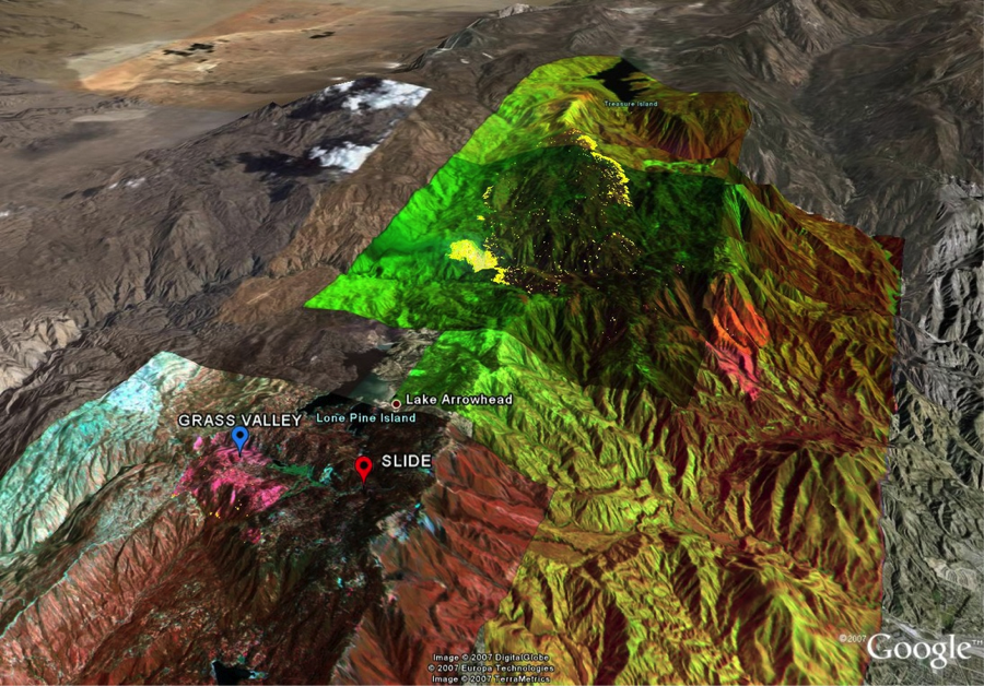
Here in the U.S., several wildfire monitoring programs have been adopted over the years. An example of such programs is the joint cooperation between NASA, General Atomics Aeronautical Systems, Inc. and various government agencies involved in fire research. The project used the General Atomics ALTUS II UAS, which is the civilian version of the Predator. Among the sensors on board the ULTUS II payload was a thermal multispectral scanner. Imagery was transmitted to the ground station through INMARSAT geostationary satellites. Once the imagery is received at the ground station, it goes through the geo-referencing and ortho-rectification processes, which convert them to a geo-referenced map before it goes into the hands of the field team. NASA published images (Figure 8.3) of the Grass Valley/Slide fire near Lake Arrowhead/Running Springs in the San Bernardino Mountains of Southern California acquired by the thermal-infrared imaging sensors on board NASA's Ikhana unmanned research aircraft. For more information on past NASA collaborative efforts in the field of different applications for UAS, visit UAS Integration in the NAS [16].
To Read
- CNN article “Fighting fire with data, spacecraft, drones [1]."
- Read the paper "Towards Low-cost Cooperative Multispectral Remote Sensing Using Small Unmanned Aircraft Systems. [2]"
- Read the article Commercial Drone Applications On The Rise | Enterprise UAV Solutions | 2018. [3]
UAS Challenges in Certain Applications
In this section, we will discuss operational challenges in using the UAS for certain applications.
So far, we have read and discussed materials about the successful utilization of the unmanned aircraft for a variety of applications. However, some of such applications are found to be challenging due to different reasons. Among such reasons are the following:
- FAA hesitates in allowing UASs to fly during natural disaster situations such as floods and hurricanes. This is mainly due to the fact that operating a UAS during a storm lacks alternative communications capabilities. During storms, the air traffic control capabilities in the affected area are usually limited, risking the safety of the UAS, which usually operates without sense-and-avoid instruments.
- UAS offers many advantages over conventional of traffic monitoring and transportation planning for police, emergency responders, and DOT. UAS can move from one location to another with higher speed and is not restricted to specific routes that are usually used by ground vehicles. In addition, UAS can fly through hazardous or inclement weather conditions. However, UAS used for traffic monitoring is challenged in urban canyon areas where visibility of the traffic on the ground is obscured by high rise buildings.
- Small UASs cannot maintain their flying routes during stormy conditions. The lightweight of the UAS makes it venerable to gusty winds.
- Here in the U.S., it is difficult to obtain the FAA proper approval to fly civilian projects whenever there are people in the project area, even after the issuance of Part 107. Such restriction is expected to be diminishing in the future as the FAA continues its efforts to integrate the UAS into the NAS.
To Read
- Sections 6.2.2 and 6.2.3 of Chapter 6 of Introduction to Unmanned Aircraft Systems.
Summary and Final Tasks
Summary
Congratulations! You have just finished Lesson 8, Civilian and Commercial Applications of the Unmanned Aerial System. You may notice that the use of UAS for civilian applications extends to almost any applications offered by manned aircraft. In fact, the UAS provides more opportunities than the manned aircraft. The UAS, with its small maneuvering size and its low-cost operation, makes them more useful and more affordable than manned aircraft. That is very true for small projects and projects that may involve hazardous operational conditions. UAS applications are expanding, and we hear about new applications every day. Amazon, for example, recently unveiled plans for UAV package delivery service [18]. What do you think the coolest application is that the UAS should be used for and that no one has thought about until now? Post your opinion in the discussion form.
Final Tasks
| 1 | Complete the Lesson 8 Quiz. |
|---|---|
| 2 | Submit your results for exercise 2 data processing in Pix4D. |
| 3 | Submit your COA Application. |