Geospatial Data Accuracy and Quality and Mapping Standards
Geospatial Data Accuracy and Quality and Mapping Standards
Introduction:
Evaluating the quality and accuracy of geospatial data is one of the most important topics among geospatial data users. Geospatial data are used for diverse applications, including engineering and positioning applications. Knowing how accurate the measurements are that are derived from geospatial data is a matter of life or death in some applications, like when locating gas pipelines. In this section, you will be introduced to various statistical concepts that are related to determining geospatial data accuracy. You will also learn about the latest map accuracy standards designed for digital geospatial data published by the American Society of Photogrammetry and Remote Sensing (ASPRS).
Metrics in Geospatial Production Process:
For any geospatial data product, collecting metrics about a dataset revolves around the following questions:
- How well does the map fit a national or a global coordinates system and datum?
- How well does the geometric and radiometric quality meet or depart from the client’s expectations or specifications?
- How well do these metrics fit a “standard” or what is considered standard within the geospatial industry?
Why we are concerned about accuracy?
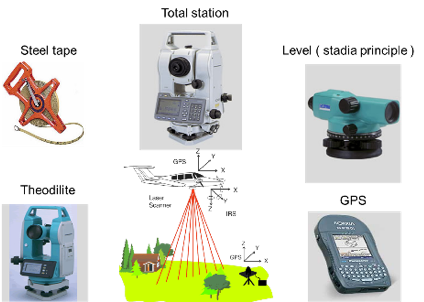
Errors exist in any product we produce, no matter how accurate the instrument or the process we utilize. This is because all measuring instruments are not perfect, including laser instruments. Figure 1 illustrates the common instruments used in surveying and mapping practices and which we may think are perfect measurement devices.