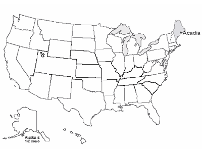
Acadia and Sea-Level Rise
The subduction and collision with Europe during the closing of the proto-Atlantic made great granite bodies draped in metamorphosed sediments, and we find these exposed along the Maine coast. Much later, the glaciers scoured those rocks clean, leaving the bald mountain tops of what is now Acadia National Park, staring out at the storm-tossed north Atlantic across Somes Sound, the only fjord on the east coast of the U.S.
The Wabanaki tribe of Native Americans probably reversed the modern tourist pattern, summering inland and then moving to the relatively more moderate coast of Acadia in the winter. Nasty winter storms do run up the coast, but the temperatures plunge far lower inland than they do on the coast. Thick piles of discarded shells of nutritious sea creatures dating back 6000 years attest to the importance of the sea to these early people.
On September 5, 1604, the French explorer Samuel de Champlain landed on Acadia’s island. Impressed by the bare, rocky, deserted appearance of the glacially scoured granite mountain peaks of the island, he named it Isles de Monts Desert.
French influence was important until the end of the French and Indian War, after which English and then U.S. activity came to dominate. In the mid-1800s, Mount Desert Island attracted the art world, and was featured in paintings by Frederic Church, Thomas Cole and others of the Hudson River School (for example, have a look at Twilight: Mount Desert Island, Maine by Frederic Edwin Church. The artists, in turn, attracted the “rusticators,” tourists who gradually were replaced by much wealthier tourists who built summer “cottages”—the Rockefellers, Fords, Vanderbilts, Carnegies, etc. These wealthy patrons in turn invested resources and political capital in preserving most of the island as a national park.
Today, over 4 million visitors per year flock to Mount Desert Island, with most of them getting out of the gift shops and into the national park. The visitors enjoy the history, the beauty, the rather chilly ocean waters (based on personal observation by the author, even on hot summer days, there is more sitting by the sea than swimming in it!), the outstanding network of paths for bicycling, superb kayaking on lakes and sea, and much more.
Changing Coasts and Sea Levels
Change is the only constant on coasts. The Sea Grant Program at the Woods Hole Oceanographic Institution, on Cape Cod, reported that about 75% of the U.S. coastline is eroding, with only about 25% stable or advancing. For Massachusetts, 68% of the coastline is listed as eroding, 30% advancing, and a mere 2% stable.
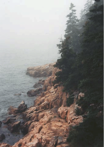
Up in Maine, the rocky parts of Mt. Desert Island are among the few places that would be classified as “stable,” although very slow erosion is occurring as the sea pounds the granite headlands. But if you look further back in time, the size of the changes becomes evident. Glacial ice overran the highest peaks in the park during the ice age. Sea level was lowered 300-400 feet (100 m or a bit more) at that time to supply the water that grew the ice sheets, but the land of Mt. Desert Island was pushed down 600-700 feet (roughly 200 m) or even more by the weight of the ice.
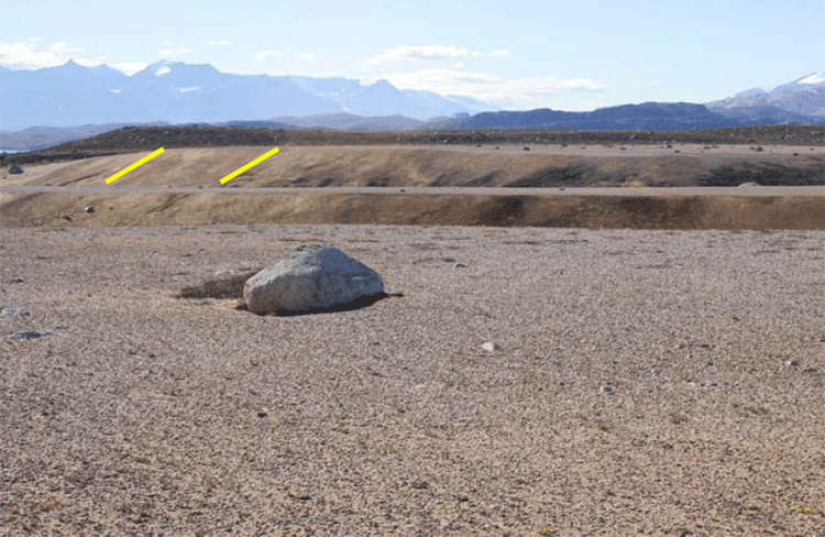
Ice farther south began melting before the ice on Maine, so the sea began rising, but then loss of ice on Maine caused its rocks, including Mt. Desert Island, to begin rising faster than the sea. The rising of the pushed-down rocks is slow, and in fact is still going on today. Thus, as the ice retreated, the already much-raised sea first flooded in across broad regions of Maine and adjacent parts of the east coast. Beaches and sea caves formed, and deltas were deposited. Then, these coastal features were raised out of the ocean as the land rebounded. Such coastal features can be found today in Acadia to almost 300 feet (almost 100 m) above the modern sea level, and similar features occur all along coastal Maine. We include a picture of a similar delta from Greenland; the features in Maine are covered with trees and houses and roads and such, and although the features are quite easily identified by experienced geologists, the features are not as clear as those in Greenland to the beginning geologist.
Regions that were slightly beyond the reach of the ice-age glaciers were pushed up in a forebulge, when the hot, soft, deep rocks pushed out from beneath the sinking ice sheets bulged up the land just before the ice. In those forebulge regions, the land now is sinking, as the deep, hot rocks flow back to their starting point; where forebulge sinking has combined with rising sea level as the ice melted, the total sea level rise has been especially large. Far from the ice sheets, sea-level rise has been about what you would expect based on the amount of water returned to the ocean by the melting ice sheets (although the entire surface of the Earth was warped by shifting water from the oceans to the ice sheets and back, so the changes are all a bit more complicated than you might expect, just as a wine glass balanced anywhere on a cheap water bed will tip over if you sit anywhere on the bed).
By now, you may be getting the idea that what happens to a particular coast is fairly complex. If mountain-building is pushing the coast up, it rises; if mountain-building is pushing the coast down, it sinks. Where plates meet, when the edges are locked and building toward an earthquake, the motion may drag one side down and push the other side up; the earthquake that follows will suddenly reverse the offset—in the great Tohoku earthquake of Japan in 2011, parts of the Japanese coast moved as much as 8 feet toward North America, and offshore the largest motions of the sea floor were more than 150 feet horizontally and more than 20 feet vertically. Where cities are built on deltas, as at New Orleans, the compaction of the mud causes sinking. Much additional sinking is caused by pumping water or oil or gas out of the ground; as the fluids are removed, the ground compacts. This is happening a little on Cape Cod, and is quite dramatic in some places. Groundwater pumping may have contributed to problems at New Orleans, in Venice, and elsewhere. (Reinjection of fluids can partially offset this problem, and is being used in some places.)
Additional complexity comes from the issues of sediment supply. Beaches inevitably lose a little sediment to deep water, somewhat like losing socks behind a clothes dryer, because it is easy to drop something that falls way down there, and hard to get it back. Waves affect sediment below the surface, but only down to a depth that equals roughly half the distance between a wave’s crest and the next one. If sediment happens to slide or bounce deeper than the depth reached by the deepest-reaching waves, then that sediment cannot be brought back easily. (The sediment can go into a subduction zone, be taken down and scraped off, or else melted and erupted and loosened by weathering and landslided and transported in a river and then in longshore drift to the beach, but that takes a long time.) And, longshore drift moves a lot of sediment, but eventually the sediment often encounters an undersea canyon and drains down to deeper water below the reach of waves.
Thus, a “happy” beach requires a supply of sediment to balance the loss to deep water. Normally, that supply comes from the material delivered to deltas by rivers, and carried by longshore drift. But if there is not enough sediment coming in this way, the beach will narrow as it loses sediment to the deep ocean, and the waves will reach across the sand to erode the material behind, gaining sediment in this way.
In those cases when longshore drift does not supply enough sand to make a beach, and the waves are battering on the coast, if the rocks are really hard, like the granite of Acadia, then there won’t be a beach at all, with the tiny bit of material eroded from the granite quickly dumped into deep water. (There are a few small “pocket” beaches at Acadia in protected places, but most of the coast doesn’t have beaches, with granite sticking right out into the waves.) If the coast is sand and gravel left by the glaciers, as seen at Cape Cod, the waves cut the coast back and supply that material to the beaches.
In some places, dams on rivers have greatly reduced delivery of sediment, so the coasts are eroding. You may recall that the dams on the Elwha River, draining Olympic National Park, caused loss of beaches along the coast. At Cape Cod, there really aren’t any rivers to dam. The glaciers made a big pile of sediment in a place where rivers are not supplying much sediment to deltas, and so the Cape eventually will be lost to deep water.
Rising Sea Level and the Future
So coasts change for many different reasons, and in many different ways. But, recently, most of the U.S. (and world) coasts have been retreating because sea level is rising, and that rise is accelerating.
The rate of rise has been about 2 mm/year (just under an inch per decade) over the last century, but seems to have sped up to about 3 mm/year (a bit over an inch per decade) recently. That isn’t much if you’re at the top of a cliff in Acadia, but if you are on a sandy beach that slopes very gradually, the inch of sea-level rise may cause many feet, or even a few tens of feet, of coastal retreat. That in turn means that a whole lot of houses and property can be lost in a single lifetime.
The ongoing sea-level rise is being caused primarily by the global average warming of the last century, which is being driven primarily by human activities (we’ll return to this later, but we have high scientific confidence that it is correct). Most of the world’s small glaciers have been melting this century, returning water to the oceans. Also, as the ocean itself warms, the water expands and takes up more room.
Two other possible causes of sea-level change are humans "mining" groundwater, and melting or faster flow of the polar ice sheets. We build dams on rivers, and the water that fills the reservoirs is taken out of the ocean and stored on land, causing sea-level fall. But, we “mine” groundwater by pumping it out of the ground faster than nature puts it back, in places such as Phoenix, Arizona where green yards and golf courses and fountains seem to “need” LOTS of water, and that water eventually reaches the ocean to raise sea level. Today, groundwater pumping is probably more important than dam building, contributing a little to sea-level rise.
The polar ice sheets contain a huge amount of water—if they melted, they would raise sea level nearly 250 feet (roughly 70-80 m). Philadelphia and the other great port cities of the world would become undersea hazards to shipping but really great places for fish to hide out, and the southern coast of Florida would be somewhere up in Georgia. We do not expect such a fate within at least the next few human lifetimes, but we cannot rule out the possibility that a dynamic collapse of the West Antarctic ice sheet could raise sea level 10-20 feet (3-6 m) in a human lifetime or two, and if we don’t change our behavior over centuries, Greenland and its 24 feet of sea level is looking shaky. Drs. Anandakrishnan and Alley spend a lot of their research trying to reduce our uncertainty about the future of the great ice sheets, a fascinating and important topic.
The near-certainty of continuing sea-level rise has some policy implications. For example, disaster aid following hurricanes that allows people to rebuild in coastal regions will simply create the need for more disaster aid in the future. Many people believe that those who wish to build on the coasts should be required to carry insurance to cover their coming losses. Similar arguments apply to those who wish to build on earthquake faults, landslide deposits, and floodplains. Why should those living in relatively safe but less-scenic places pay for others to live in dangerous but beautiful places?
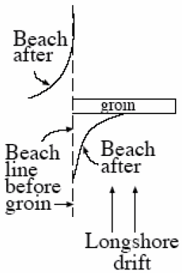
Because people love the coasts so much, and wish to live near them, all sorts of engineering solutions have been tried. One is to build “dams” (usually called “groins” if they are small, or “jetties” if larger) that stick out into the water and block the longshore transport of sand (see figure to the left). By making the coast rougher, and slowing waves, the plan is to trap sediment along the coast the way a dam traps sediment along a river. This plan sometimes works. However, recall that in a sand-bedded river, sediment is trapped upstream but eroded downstream. The same often happens along a coast; sediment is trapped “upstream” of the groin (on the side from which the longshore drift comes), but sediment is eroded on the “downstream” side (the side to which the longshore drift goes), where the sand-free waves attack the beach to pick up more sand. Saving someone’s beach while destroying the beach of a neighbor is a good way to generate lawsuits. People also spend millions of dollars to go out to sea, find sand that has fallen off into deep water, and bring the sand back to the beach. This sand usually lasts a single year or a very few years before being washed back to deep water, but in especially popular tourist destinations, the investment may pay off.
Geologists often take a “natural” view of the coasts—we should figure out where the coast wants to go, and build there rather than trying to stop the coast. But many people just don’t like that, and a lot of construction is likely to occur—and be destroyed—over the years.