Stratigraphy and Arches
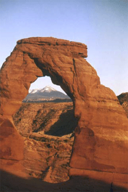
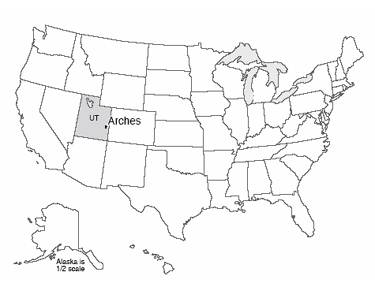
Arches National Park is just outside of Moab, Utah, almost within shouting distance of Canyonlands. Arches contains the largest concentration of natural stone arches in the world, with dozens of major arches, and numerous other holes and interesting rock features. The longest natural arch in the world is there, Landscape Arch, spanning about 300 feet (almost 100 meters). Several rockfalls have occurred from Landscape Arch since European settlers arrived, reducing the arch to a thickness of only 11 feet in one region. The trail under the arch has been closed; the Park Service knows that eventually more rocks, and the whole arch, will fall, and the rangers do not wish to be involved in extracting compacted humans from beneath the remnants of what used to be the world’s longest arch.
The arches are all eroded in sandstone, and especially the mid-Mesozoic (deposited during the time of dinosaurs) Entrada Sandstone, which includes both marine and wind-blown sands. Arch formation started with deposition of thick beds of salt in the Arches area. Sediments including the Entrada sands were deposited on top of the salt, and cemented by hard-water deposits to make sandstone. When the weight of those sediments became large enough, the salt began to flow, squeezed from places where thicker sediments caused higher pressure on the salt, to places where thinner sediments gave lower pressure, like ketchup in a fast-food packet squeezed from one place to another. However, the foil wrapping of a fast-food packet is fairly flexible, but the Entrada sandstone was not, so as the salt moved, the tough sandstone broke. The most common joints formed by this motion are parallel, nearly vertically oriented, and a few yards (or meters) apart. Weathering processes attacked the rocks along these joints, which were slowly widened to leave vertical slabs of rock called fins.
Some weathering and erosion processes are more effective near the ground than high up. For example, you will see huge steel bolts sunk into the rock of some road cuts just above the highway to keep the weight of the rock above from popping slabs of rock loose that might blast into the road and kill people; such rock-bursts also occur in quarries. When such slabs of rock fall, they often leave a curved or arch-like top, because it is easier to break off a curve than a square-cornered piece. This process is among those contributing to arch formation, breaking through the fins to make the beautiful stone arches.
Stratigraphy
The text above says that the Entrada Sandstone is from near the middle of a time we call the Mesozoic, an Era of geologic history, and for Bryce, our text told you that Bryce Limestone is from early in the Cenozoic Era of geologic time. You have not been asked to learn these terms yet (but you will be, so might as well lodge them in your brain now). The Mesozoic is older than the Cenozoic, so the Entrada is older than the Bryce. How do we tell which layers are older or younger?
Putting rocks in order is an enjoyable puzzle, requiring the sort of logic used in sudoku or in crossword puzzles. You rely on a few general principles that really boil down to common sense, plus a lot of puzzling and looking and thinking. Start with “what’s on top”? The layer of mud that settles out of floodwaters is deposited on top of the mud and grass and linoleum and grand pianos of the flood plain. Naturally, the mud from the flood of the next year is deposited on top of the mud from this year (nature doesn’t dust the grand piano). In ordinary sedimentary rocks, the youngest ones are on top and the oldest on the bottom. We call this the Principle of Superposition.
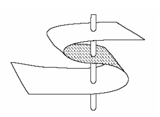
Note that this applies to ordinary rocks. There are cases in which rocks are turned upside down. Take a sheet of paper on your desk, put fingers on opposite sides and squeeze your fingers and the ends of the piece of paper towards each other (see the figure on the left). The paper will buckle into a fold. If you get your fingers together, the fold may “fall over”. A vertical hole through your paper would now go through the top of the page and out the bottom, but then through the bottom of the page and out the top, before finally going through the top and then the bottom—going from top to bottom, the paper is right-side up, then upside-down, then right-side up (look at the figure again).
Fortunately, there are many “up” indicators in rocks that tell you which way was up when the rock was formed. Animal tracks and raindrop imprints are made down into mud, not up. If you find a track pressed up into the roof of a cave, it is reasonable to suppose that the track originally went down but then has been turned over, so it is now upside-down. Mud cracks narrow and disappear at the bottom, not the top. Curved clam shells are usually flipped by currents into the stable, hollow-side-down configuration rather than the rocking, hollow-side-up configuration. Bubbles in lava flows rise to the top where they are trapped just beneath the quick-cooled upper surface; the bubbles do not sink down to the bottom. (You will meet some of this in the second V-Trip, and in the Rockin' Review of this chapter, and in Exercise 4.) Hence, you can learn whether the rocks have been turned upside-down or not.
In clastic sedimentary rocks, the clasts must be older than the rock is. So a conglomerate containing pieces of granite and of other things tells of formation of a granite from melted older rock, followed by physical erosion to break the granite into pieces, followed by transport to mix the granite pieces with chunks of other rocks, followed by deposition of the chunks and hard-water cementation to make the conglomerate rock. A conglomerate containing pieces of sandstone tells of two cycles—make the sand from older rocks (perhaps from breakdown of a granite by chemical weathering), followed by transport of the sand to a beach, followed by cementation of the sand with hard-water deposits to make sandstone, followed by physical weathering of the sandstone to make sandstone chunks, followed by transport of the chunks and mixing with others and deposition and cementation to make the conglomerate. If a fault has split a granite clast in a conglomerate, and moved one side relative to the other so that the pieces no longer match, the fault must be younger than the conglomerate—something must exist before you can break it. If a layer of sandstone is standing up on edge, then it must have been deposited, hardened, and then tilted—because of mass-movement processes, layers are nearly horizontal when deposited (not exactly, but pretty close); if you tip a mud layer up on end before it has hardened, it spreads into a new, nearly horizontal layer.
Below is a photograph of an outcrop near I-70 in the near-desert conditions of central Utah (left), and a sketch of the outcrop (right). The rocks at the bottom were deposited on a sea coast—they contain marine fossils and other markers of the sea, and are mostly sandstone and shale. But they are standing on edge and truncated at the top. Developed on the top of them is a soil, and on top of that are lake deposits with flamingo bones, fish fossils and alligator bones.
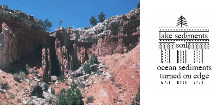
The story of this outcrop includes:
- Some history to produce sand and mud and deliver them to the sea, where they were deposited and then hardened;
- A mountain-building episode to turn the rocks up on edge;
- Erosion to truncate the rocks, together with weathering to create the soil;
- Growth of a lake, with sediment accumulation in the lake;
- Drying or draining of the lake; and
- Erosion to reveal a cross-section of the deposits.
You can postulate many other things—Dr. Alley is just lying about the rocks; or, the space aliens put the rocks there; or, a giant tornado blew the rocks there one afternoon; or…. We humans are very inventive, and can always come up with a new idea. But when you follow out the implications of these other stories, some fundamental problem always comes up, whereas the story of the rocks being deposited and hardened and tipped on end and eroded and so on works just fine, and makes predictions that are borne out over and over. Hence, the “geological” or “scientific” interpretation is the sensible one.
Notice that the erosion surfaces [events iii and vi in the list above] represent time gaps in the sedimentary sequence; the rocks at this site do not have a record of the environment during the time erosion was occurring—you have to go to where rocks were being deposited to learn that. A time gap in a sedimentary sequence, whether from actual erosion or just lack of deposition, is called an “unconformity”. Most of the land experiences erosion most of the time—the mud in the Mississippi is eroded from the lands upstream, and most of us most of the time do not have to worry about mud being deposited on our grand pianos or carpets. But, sediments are deposited on land, and sediments are deposited almost everywhere almost all the time under the sea, allowing a fairly complete story to be told.
Fossils and Relative Time: The Law of Faunal Succession
The material above explains how geologists can put rocks in order. The job may be quite difficult, because some outcrops are covered by soil, water, or other rocks, because offsets on faults may be so large that rocks on opposite sides can’t be matched back up easily, etc. But the job can be done.
When this job is done, a remarkable result emerges. Many rocks contain fossils, and different rocks contain different fossils. Arranging the rocks in order reveals that the fossils also are arranged in order. Rocks of similar age from similar environments have similar fossils; the more different the ages of the rocks (the farther apart they are in our ordered pile), the more different the fossils appear. The younger fossils have more in common with things living today than do the older ones. This observation, that fossils succeed one another in a definite and recognizable order, is called the Law of Faunal Succession. “Law” here is not something passed in Congress; a scientific “law” such as this one successfully summarizes an immense number of different observations, and works very well in explaining and predicting many different things in many places and times.
The Law of Faunal Succession was developed in England by a 17th century canal engineer/geologist named William Smith. He faced practical problems; digging in some rocks is easier than in others, some rocks hold canal water better than others, etc. If he crossed a river or a region with no rocks showing, and then found a few rocks, he wanted to know whether they were the ones he wanted, or whether the ones he wanted were up or down in the pile. Sometimes, a few fossils would be evident in a streambed, or even would be in use as weights for balances to weigh cheese of the local farmers, and he found that the fossils made his job easier by providing shortcuts for putting things in order.
Much later, faunal succession figured in the debates over evolution. But you should remember that the Law of Faunal Succession is like so much good science—a practical idea that gives useful results and helps humans do things successfully.
The Geologic Time Scale
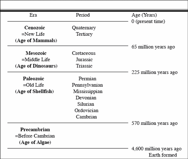
| Era | Period | Age since end of period(Years) |
|---|---|---|
| Conozoic = New Life (Age of Mammals) | Quaternary, Tertiary | 0 (present time) |
| Mesozoic = Middle Life (Age of Dinosaurs) | Cretaceous, Jurassic, Triassic | 65 million years ago |
| Paleozoic = Old Life (Age of Shellfish) | Permian, Pennsylvanian, Mississippian, Devonian, Silurian, Ordovician, Cambrian | 225 million years ago |
| Precambrian = Before Cambrian (Age of Algae) | None Listed | 570 million years ago |
Geologists learned to put rocks and fossils in order long before calendar-year ages could be assigned accurately (how many years old is that?). Lacking accurate year counts, the early geologists agreed on a “shorthand” for describing ages. Time is divided into big chunks, called “eras,” which are themselves divided into smaller chunks, or “periods,” and on into still smaller chunks. The big chunks (which you would be wise to know) are, from youngest to oldest, the Cenozoic (= new life), the Mesozoic (= middle life) and the Paleozoic (= old life) (see the table on the following page).
The oldest period in the Paleozoic is called the Cambrian, and the rocks older than it are called the Precambrian. As the Precambrian includes most of the history of the Earth, more and more workers are using “-zoic” terms for pieces of it (see the Enrichment for Unit 9). The periods are mostly named for places where the rocks are well-developed, such as the Cambrian for Cambria (also known as Wales), Devonian for Devonshire in southwestern England, and the Pennsylvanian for Pennsylvania (Europeans usually lump the Mississippian and Pennsylvanian and call that lump the Carboniferous, but we have such wonderful deposits of their Carboniferous that we divide them to allow better time resolution, and to use our names). The youngest two periods, the Tertiary (third) and Quaternary (fourth), were named in an old scheme that also included primary and secondary; history dies hard in geology.
Life appeared early in the Precambrian, and multicelled organisms were present in the Precambrian. The Cambrian began with a great diversification of organisms with shells. Older fossils are rare because soft body parts usually are not fossilized; when shells appeared, they accumulated to make limestone layers, so fossils “suddenly” (over a few million years) became common. The Paleozoic and the Mesozoic ended with mass extinctions that probably killed the great majority of organisms on Earth (we’ll return to this soon). The mass extinction at the end of the Mesozoic was caused by a meteorite impact at the end of the Paleozoic that is not fully explained, although radical changes in ocean circulation in response to global warming and massive volcanism that produced a widespread lack of oxygen in the ocean probably were involved.