Death Valley is Growing Wider: Death Valley and Sea-Floor Spreading
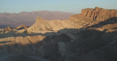
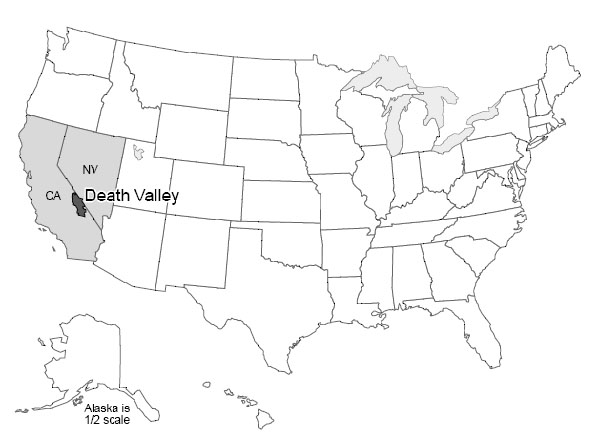
Death Valley National Park of California and adjacent Nevada sits as deep as 282 feet below sea level near Badwater, the lowest land in the western hemisphere. Yet, Telescope Peak in the Panamint Range, 11,049 feet high, is in the park less than 20 miles west of Badwater, and Mt. Whitney, at 14,494 feet the highest peak in the continental United States, is only about 80 miles away.
Death Valley is the hottest, driest place in the United States. On July 10, 1913, the temperature reached 134oF (57oC), and 125oF is common. All of the rainfall (about 2 inches or 5 cm per year) evaporates quickly.
Occasionally, water will sit on mud flats for a while (especially in the colder winter) before evaporating to leave salt deposits. Sometimes in winter, the water freezes on top, and strong winds blow the ice, dragging rocks that are frozen in it. The tracks of such rocks, at the Devil’s Race Track, long puzzled people before the answer was discovered. (And you’ll still find people who argue about the tracks and rocks out on the flat surface—no one has ever watched the rocks when they were moving!) During the ice age, more rain and cooler temperatures than today caused the valley to fill with water, forming Lake Manly, which was about 90 miles (150 km) long and almost 600 feet (200 m) deep at its deepest.
Salts left on mud flats by evaporating waters often contain boron, a rare element that has leached from volcanic rocks nearby and been carried into the valley by streams. Boron is used in soaps, water softeners, pottery glazes, and other things. Mining of the boron-bearing borax salts began in the early 1880s, and they were hauled out by the famous 20-mule teams. Mining was allowed to continue in the park after it was established (as a national monument in 1933, and a national park in 1994), but is being phased out. Copper, gold, silver, lead, and talc has been mined in or near the park.
Pull-Apart Faults
The great depth of Death Valley was not carved by a river or glacier or the wind, and is not from a cave-like Mammoth Cave collapsing. Instead, as shown in the diagram below, labeled Pull-apart fault at Death Valley (which is more-or-less what you would see if you could take a slice across the valley from the air at the top down into the Earth at the bottom), Death Valley has been dropped along faults as the region has been pulled apart. Similar down-dropped and upraised blocks extend across much of Utah, Nevada, and neighboring areas, forming the Basin and Range region. A little bit of such faulting even extends up into Wyoming, and the great front of the Teton Range is geologically a close cousin to the west side of Death Valley.
The geologic evidence of faulting is clear—layers of rock and even recent stream deposits are offset across the faults, as you'll see in a VTrip at the end of this unit. The faulting occurs in fits and starts rather than smoothly, producing earthquakes. The Basin and Range regions remain active in producing earthquakes. (More about earthquakes is coming soon.)
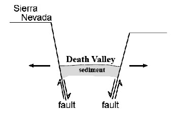
Because of the way that the faults are angled, the dropping of blocks requires that the region is getting wider! (Look again at the diagram to the right labeled Pull-apart fault at Death Valley.) It has recently become possible to measure this widening using GPS or very-long-baseline-interferometry techniques. The widening is not fast—maybe an inch or two (a few centimeters) per year across the whole Basin and Range—but the widening is occurring.
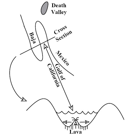
Go south from Death Valley and you will splash into the Gulf of California. The geologic record shows that all of Baja California was attached to the main part of Mexico, but has been moved out to create the Gulf, and is still moving out. Eventually, the Gulf may extend up into Death Valley as the spreading continues and the west “unzips,” although the unzipping may stop before the whole west is opened up (see figure below — Pull-apart fault in the Gulf of California).
Next, boat across the Gulf with a depth-finder running, and you will see that there is a ridge down the middle of the Gulf. Get in your submarine and dive on that ridge, and you will find that it is a volcano. Lava leaks up along a crack in the middle of this ridge volcano, hardens, and then moves slowly away as new lava leaks up along the crack. Interestingly, lava also leaks into Death Valley along its faults, with eruptions within the last 200 to 300 years.
Sea-Floor Spreading
Next, follow this ridge volcano south. You will find that it runs into the open Pacific Ocean and then wraps around the globe through all of the world’s oceans, like the seam on a baseball. The ridge runs right up through the middle of the Atlantic (coming to the surface in Iceland). (Because the ridge is in the middle of the Atlantic, and the middle of the Gulf of Mexico, and the middles of some other ocean basins, it is often called a mid-oceanic ridge, although in some places the ridge is most assuredly not in the middle of the ocean.) Study the seafloor, and you will see that it is made of rocks that are young—they hardened as the lava cooled recently—near the ridge, with older rocks—they hardened as the lava cooled a long time ago—as you move away in either direction. We will discuss how we learn the ages of rocks later; for now, please accept that the rocks, and the sediments just above the rocks, are progressively older with increasing distance from the ridge.
Everywhere we meet the ridge, it is shallow and hot. The rocks that form at its volcano slowly cool as they move away, contracting and sinking. The ridge is a bizarre place in many ways—water circulates through cracks in the hot rocks, dissolves many chemicals in the rocks, and emerges as “black smokers” where the minerals reprecipitate or “rainout” in the colder ocean as a sort of black dust or as a cone around the emerging water. Many valuable ore deposits were originally formed from the chemical precipitates around these black smokers. An entire ecosystem of tube worms, clams, etc., lives on bacteria that use these chemicals for a fuel source, rather than relying on the Sun for energy, as do most living things.
Heat Inside the Earth
We just discussed a lot of observations—a baseball-seam volcano through all the world’s oceans that is making seafloor and splitting and spreading continents and ocean basins. Explaining these observations will tell us much about the Earth and how it works.
The existence of volcanoes, bringing melted rock up from below, tells us that the Earth is hotter inside than at the surface. We learn the same in deep mines and drill holes—the Earth is warmer towards the center (once you get below the top thirty feet or so that are warmed a little by the summer and cooled by the winter). All rocks contain radioactive elements (mostly uranium, thorium, and radioactive potassium, but with some others). Radioactive decay of these makes heat in the Earth, much as radioactivity produces heat in nuclear power plants. Most of the Earth’s heat comes from this radioactive decay, although some heat is left over from when the Earth formed, or is being released as the core freezes, or the core, mantle, and crust continue to separate and things sink and give up heat from friction.
Heat is just the vibration of the atoms from which everything is made. More heat causes more vibration. Temperature is a measure of these vibrations; more vibration gives a higher temperature.
Heat is moved around in three main ways: radiation, conduction, and convection. Vibrating atoms give off electromagnetic radiation. The electromagnetic radiation that comes from very hot atoms is visible to us and is called light; cooler atoms give off infrared or other electromagnetic radiation we cannot see. When an atom gives off electromagnetic radiation, the atom cools and slows down, unless it receives other energy to speed it up again. You soak up electromagnetic radiation if you lie out in the sun (and may get skin cancer as it damages the DNA in your skin), and you can feel electromagnetic radiation if you hold your hand off to one side of a hot stove burner. Electromagnetic radiation is a very efficient way to move heat from the sun to the Earth through space and our atmosphere, but radiation is a very inefficient way to move heat through rocks—the radiation doesn’t get very far before it is absorbed. (Thus, you cannot see far through most rocks.)
If a rapidly vibrating atom (a hot one) sits next to a slowly vibrating atom (a cold one), collisions between the two will tend to slow down the fast one and speed up the slow one. This process is called conduction and moves heat energy from atom to atom. Conduction is a very rapid process over short distances. (If you foolishly touch a hot stove burner, you will almost instantly realize how quickly it makes the atoms in your skin vibrate rapidly, and how much damage can be done if they vibrate too rapidly and jump out of those places where they are supposed to be in your skin.) Conduction is a very slow process over long distances. Think of standing in a line of 1000 people. If you push your neighbor, the response is almost immediate. But if you wish to disturb someone at the other end of the line, pushing your neighbor who pushes her neighbor who pushes his neighbor... it becomes very inefficient. For the Earth, the distance from the center to the surface is about 10,000,000,000,000,000 atoms. The Earth is not old enough for heat trapped at its center when it formed to have been conducted to the surface.
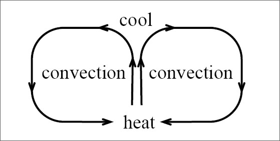
Convection is the third option for moving heat. Take something hot, and move it from here to there. To get heat from the stove to your dinner table, you cook things on the stove and then carry them to the table, which is much more efficient than putting the food on the table and waiting for conduction or radiation to bring heat from the stove.
Nature has a special way to arrange this motion in many things. Heating causes almost all materials to expand because hotter molecules vibrate more rapidly and tend to bounce farther away from each other. This lowers the density of the material; its mass is the same, but it takes up more room. Low-density materials tend to rise, and high-density materials tend to sink. This leads to convection currents—a material is heated, rises, cools, and sinks. Typically, rising occurs in one place, the material flows along while it cools, then it sinks and flows back to the rising point (see the convection figure above). (Technically, moving heat by rising of materials that expanded when they were heated is called “convection,” and moving heat by transferring hot materials in other ways is called “advection,” but introductory texts usually call it all “convection.”) You should have seen the effects of convection currents in the air (we’ll talk about them later, but they produce wind, rain, etc.), and in the boiling water of a pot of spaghetti on the stove. We believe that convection currents occur in the Earth as well. This may seem odd at first because most of the Earth is solid rather than liquid. (Volcanoes come from a depth where there is a little bit of liquid, but even there most of the rock is solid.) However, sufficiently hot rocks are soft enough to flow slowly. Again, we will discuss this later, but it is the same principle that allows a blacksmith to work hot iron into horseshoes, or allows a chocolate bar to droop on a hot day.
Our modern picture of the Earth, then, is that it is heated inside, mostly by radioactivity. That heat cannot escape easily by radiation or conduction. When the Earth was young, the heat stayed in and warmed the planet. When the rocks became hot enough, they began to convect. The planet probably melted completely and convected vigorously, followed by solidification that slowed but did not stop the convection.
In convection, the hotter rocks rise and then spread. Rising occurs beneath the ridges in the oceans. There, the new seafloor is made and then rafted away on the spreading convection cells. Where a spreading zone passes under a continent, the continent is thinned and stretched and may be torn apart to make a new ocean. This is occurring under East Africa in the rift valleys, and in the Basin and Range of the western United States—including Death Valley—and occurred to open the Gulf of California, moving Baja away from the mainland. (There may be convection cells stacked on top of each other in the mantle, and other complexities—if we tried to cover all of the wonderful complexity in an introductory course, some of you would be overjoyed but many of you would be unhappy—but this is a good start.)
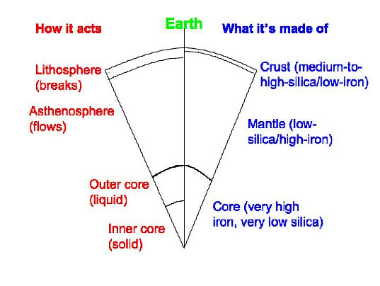
The Earth is layered chemically into a medium-to-high-silica crust, a low-silica mantle, and an iron core (well, there’s a good bit of nickel in the core, too). The Earth is also layered based on its ability to flow rather than break (see the Cross section of the Earth figure on the right). The lithosphere includes the crust and upper mantle. The lithosphere can flow a little in some places but usually breaks rather than flowing if you hit it or squeeze it or pull it with sufficient vigor. Below the lithosphere, the asthenosphere is that part of the mantle that flows rather than breaking, and from which many spreading-ridge volcanoes come. The topmost layer of the mantle is the bottom part of the breaks-rather-than-flows lithosphere. Below this in the mantle is the flows-rather-than-breaks asthenosphere, and then other layers that also flow rather than break, and that we don’t make you learn. And the core has a liquid outer part and a solid inner part.
The lithosphere is broken into a few basic pieces called plates. These float around on the convecting, soft asthenosphere. A plate may include just continental rocks, or just sea floor, or some of each. A plate map is given in chapter 3, in section 3.2 on Olympic National Park. The study of these plates and how they move and interact with each other is called “plate tectonics.”