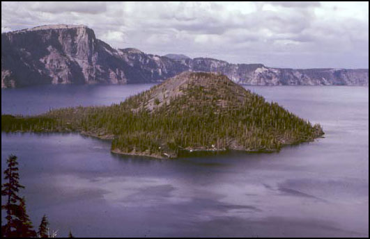
Crater Lake, at 1932 feet (about 600 m) deep, is the deepest and probably the cleanest lake in the United States, and surely among the most beautiful. Crater Lake sits in a great volcanic crater or caldera, 5 miles (8 km) across, formed when Mt. Mazama experienced a cataclysmic eruption about 6600 years ago. That massive eruption laid down ash that is 200-300 feet thick (almost 100 m) on the flanks of the volcano; the ash forms a recognizable layer hundreds of miles away in Yellowstone, and has been identified in Greenland ice cores.
The peak of the volcano had risen more than a mile above its mile-high base on the highlands of southwestern Oregon, but the great eruption removed about 4000 feet (1200 m) from the mountain’s height. About 16 cubic miles (40 cubic km) of rock were blown away. Glaciers had flowed down from the mountain peak; today, the glacial valleys can be followed upward until they disappear at the caldera rim. Although 50 feet (15 m) of snow falls in a typical year now, melting in the summer is sufficient to remove all this snow, and no glaciers exist. A tongue-in-cheek Christmas celebration on Aug. 25 substitutes for the snowbound December event.
After the great eruption, lava flows began building Wizard Island. If the water were removed from the lake, you could see that Wizard Island is roughly 0.5 mile (0.8 km) high. No permanent streams feed into the lake; the great rainfall and snowfall in the crater are balanced by evaporation, and by seepage through the rocks and eventually out the sides of the volcano as springs. With no streams supplying sediment, the lake is exceptionally clear and clean. Aquatic moss receives enough sunlight to grow 425 feet (130 m) below the water surface. When trout were stocked in the lake, freshwater shrimp were stocked first because otherwise biologists feared that the trout would have nothing to eat.
We will discuss volcanoes soon. For now, note that Crater Lake sits atop one of a string of volcanic peaks: Lassen Volcanic National Park and Mt. Rainier National Park preserve other peaks in the Cascades range. Mt. St. Helens, Glacier Peak, and several others are protected federally. These peaks line up in a row, called a volcanic arc, parallel to the coast. A similar arc sits along much of Central America, and forms the Andes of South America. And similar arcs also occur as island chains—the Aleutians, Japan, and others. In fact, the Pacific Ocean is almost entirely encircled by such volcanic arcs, forming the “Ring of Fire”.
Ring of Fire
Sitting offshore of the Ring of Fire is a ring of trenches, which include the greatest depths of the ocean. The trenches parallel the arcs. Some trenches, which sit near continents, are nearly filled with sediments dumped off the continents, but other trenches are almost free of sediment and so have very deep water, to almost 7 miles (11 km) deep. (Figuring out depths often is complicated by sediment. The surface of Death Valley sits more than two miles lower than the adjacent peaks of the Sierra Nevada. But below the salt flats of Death Valley there are sediments as much as three miles thick, materials that were eroded off the tops of the peaks, so the valley has dropped by much more than three miles relative to the peaks.)
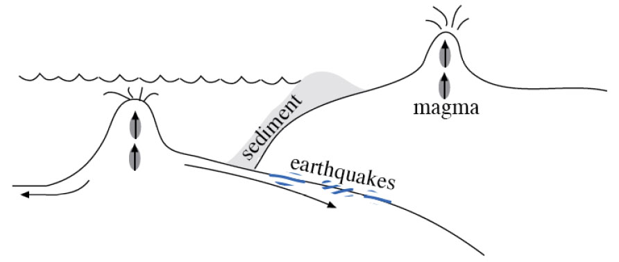
The trenches and volcanoes that ring the Pacific are clues to help solve a problem that might have been bothering you from last time. If the sea floor is made at spreading ridges and then moves away, where does it go? The earth is not getting bigger. (Well, meteorites are adding a tiny, tiny bit, but not nearly enough to account for sea-floor spreading.) So, the sea floor must be disappearing somewhere. The oldest sea floor we know of is only about 160 million years old, but the continents contain rocks as old as almost 4 billion years, suggesting that the sea floor is being consumed before it gets very old. (Remember, before the class ends, we’ll discuss how geologists date rocks.) (And remember that when a geologist dates a rock, it involves physics or chemistry but not dinner or a movie.)
Now, a few more clues. Sea floor is made of basalt. This is just the kind of rock that would be made if you melted a little bit of the deep, convecting rocks of the Earth’s mantle, and let that melt float up to the surface and “freeze” (cool until it solidifies). If you take basalt, a little ocean sediment, and some ocean water, and heat them enough to cause a little melting, let that melt come to the surface and freeze, you obtain a rock called andesite with a little more silica and a little less iron and magnesium than basalt, lighter in color and lower in density than basalt. Interestingly, the dominant rock in the walls of Crater Lake, and in the other Cascades and Ring-of-Fire volcanoes, is andesite (named after the Andes, which are part of the Ring of Fire).
If sea floor were plunging under the continents and melting to make andesite, you might expect that occasionally the down going rocks would get stuck and then break free, making earthquakes. Indeed, a three-dimensional map of earthquakes shows that shallow ones occur near the trenches, and the quakes are progressively deeper inland beneath the volcanic arcs. The great 1964 Alaska earthquake was such an earthquake, which happened where rocks of the Pacific Ocean floor plunge to the north under coastal Alaska and the Aleutian chain. The earthquakes there are shallow to the south and deepen to the north, along the down going rocks. The disastrous 2011 Tohoku earthquake in Japan was of the same type.
Careful work on the speed of earthquake waves, which is affected by the temperature of rocks, even provides a picture of cold slabs going down into the hotter mantle. As these down going slabs of rock are heated, with their water and sediment, a little melt is produced. (Interestingly, wet rocks melt at a lower temperature than do dry rocks, just as adding a little water to flour and yeast speeds cooking in the oven.) When the melt rises to the surface and cools, andesite forms, such as is seen around Crater Lake, in the Andes, or in the Aleutian volcanoes.
So, sea floor is made at the spreading ridges. It is hot and low-density initially, but cools and contracts as it gets older and loses heat to the colder ocean water. When the sea floor becomes cold and dense enough, it can sink back into the mantle, and we call the place where it sinks a “subduction zone”. The sinking sea-floor slab drags along a little sediment and water, warms up and melts a little of the slab and some of the sediment, and feeds the volcanic arcs. Old sea floor is going down around much of the Pacific Ocean, and in a few other places, such as beneath the Caribbean and beneath portions of the Alps. Wherever this happens, andesitic volcanic arcs form (see Figure 1).