Grocery Shopping at Olympic National Park
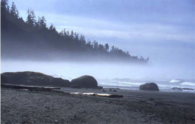
The Olympic Peninsula juts out into the Pacific Ocean, separated from Seattle by Puget Sound. Moisture-laden winds off the Pacific dump more rain and snow on the Olympic than anywhere else in the lower-48 United States. Great old-growth forest trees—Sitka spruce, Douglas fir, etc.—tower up to 300 feet (almost 100 m) above the forest duff, where butterflies flit past crystalline streams and cascading waterfalls. Along the coast, sea lions bask on offshore stacks, while urchins and starfish populate tidal pools. On the “high peaks,” numerous glaciers form and flow downhill. More snow accumulates than melts above about 6000 feet (2000 m). On most mountains, you have to go much higher to find summertime snow, but the huge winter snowfall on the Olympic allows the peaks to be snow-clad year-round despite rising less than 8000 feet (about 2500 m) above sea level.
Olympic National Park is a bit unusual in that it was established as much for biological reasons as for geological—to protect the Roosevelt elk that live on the peninsula. (The elk, named after Theodore Roosevelt, were critical in obtaining national monument status, which was signed by President Theodore Roosevelt. Later, the upgrade to national park status was signed by President F.D. Roosevelt. The Roosevelt elk is the largest of the elk subspecies in the country. Some consideration was given to naming the park Elk National Park before Olympic was chosen.)
The geologic story of the Olympic is somewhat shorter and less dramatic than for most of the national parks. The rocks of the Olympic are almost all young--less than 40 million years. (Again, please bear with us—we will justify these numbers before the course ends!) Before that, the coastline must have been farther to the east, perhaps in North Cascades National Park, and before that even farther east.
The Olympic Grocery
You’re standing at the grocery-store checkout. You put a bag of potato chips on the conveyor, and off they go, followed by a case of Pepsi, three loaves of bread, a watermelon, a box of Ho-Hos, and a sack of potatoes. Then, you realize that there is no bagger working, and that everything is piled up at the end, in a BIG mess. That mess is a good model for the Olympic Peninsula, and the whole coast from there up to Alaska.
The rocks of the Olympic Peninsula are a mixture of sea-floor basalts and of the sorts of sediments that accumulate today off the coast and fill the trench there. Rivers draining the peninsula, and much of the West Coast, carry great loads of sediment down to the ocean. Much of that sediment piles onto sea floor that is slowly moving beneath the continent, a conveyor belt that tries to pull the sediment down to melt and be erupted. Most of those sediments are “scraped off” on the way down, just as at the grocery store. The Olympic Peninsula is the off scrapings. Most of the rocks have been bent and twisted from the attempt to shove them under the continent (think of the potato chips after the Pepsi hits them!). Some of the Olympic rocks have been heated a good bit—the conveyor belt took them down a ways, but they then were squeezed back out.
Our emerging picture of plate tectonics is that the earth is heated inside, softening the deep rocks of the asthenosphere enough that they can move in great, slow convection currents that transfer heat from deep in the earth to near the surface. Heat is conducted through the upper rocks, or is erupted through them by volcanoes, and eventually is lost to space. But, the upper rocks in most places are cold enough that they tend to break rather than flow—they are brittle. These brittle rocks form the lithosphere, which includes the crust and the uppermost mantle. The rocks of the crust in continents are rich in silica (often like andesite in composition), making them light in color and low in density, so that they float on the deeper rocks and are rafted around on them by the moving convection currents. The sea floor rocks in the crust fall between the continents and the mantle in composition, and typically are basalt. The sea-floor rocks are usually intermediate between continents and mantle in density as well, but if the sea-floor rocks are cold enough, they will be slightly denser than hot mantle. Then, the sea-floor lithosphere consisting of the sea-floor crust plus a little attached mantle will sink into the asthenosphere of the deeper mantle.
The lithosphere is broken into a few big rafts, called plates—eight big ones plus some smaller ones, depending a little on how you define “big” and “small”—that float around on the convection cells below. Plate boundaries include spreading ridges where the plates move apart (remember Death Valley and the mid-ocean ridges), and subduction zones where the plates come together and one side sinks under the other. You might imagine that if plates can come together or pull apart, they must be able to slide past each other as well, which is what happens at the San Andreas Fault in California (we met it when we were discussing earthquakes); such slide-past boundaries are often called transform boundaries or transform faults (see Figure 1). You might worry that sometime, two continents would run together; we’ll meet that soon when we visit the Great Smoky Mountains.
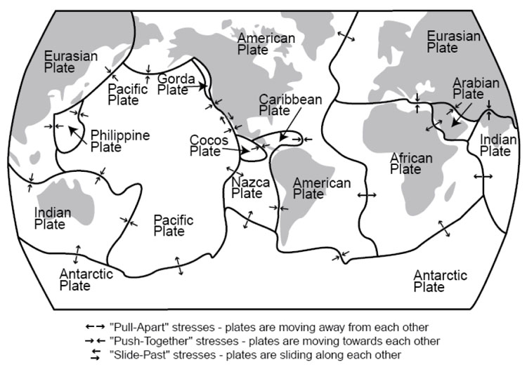
Plates shown are as follows:
- Eurasian Plate
- Indian Plate
- Antarctic Plate
- Pacific Plate
- Philippine Plate
- Gorda Plate
- Cocos Plate
- Nazca Plate
- Caribbean Plate
- American Plate
- Arabian Plate
- African Plate
The lithosphere and asthenosphere are solids, but a little melted rock may occur in the asthenosphere, and leak out where plates are pulled apart, feeding basaltic volcanoes. And the water taken down subduction zones can stimulate a little melting, feeding andesitic volcanoes that line up in arcs above the downgoing slabs of the subduction zones; examples of these volcanic arcs include the Cascades, Aleutians, and Andes. Continents are a collection of scum from melting of the mantle, too low in density to sink back into the mantle. Continents grow as the conveyor belt from the mid-ocean ridge to the subduction zone brings in sediments and islands and what-not, or when andesitic volcanoes are erupted on continents, or when andesitic volcanoes form an arc offshore that then collides with a continent (sometimes the site of subduction moves, and the volcanoes find themselves on the conveyor belt, or they hit a different continent). Because much of the sediment comes from the continents themselves, the growth of continents is not fast—material eroded from the continents falls on the conveyor and is added back at Olympic or erupted back at Crater Lake.