Coasts and Cape Cod
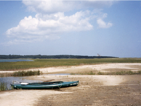
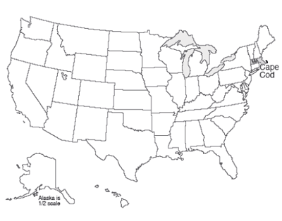
The author, Dr. Alley, is a lucky fellow. Through a fortuitous sequence of events, which involved marrying the right woman who had the right grandfather who was related to some people who have roots in the right place and worked to preserve those roots, our family has been able to occupy a room in the smallest of three houses in a “compound” in Eastham on Cape Cod for a couple of weeks during many summers. The land now belongs to the National Park Service as part of the Cape Cod National Seashore, but the houses were “grandfathered” and remain in the extended family. The bicycle trail to the Coast Guard Beach crosses the driveway, the Salt Pond Visitor Center is just around the corner, and the boat houses face Salt Pond Creek that opens on the Nauset Marsh.
Cape Cod is a glacial moraine. The part that attaches to the mainland marks the end of a lobe of the Canadian ice sheet. The “forearm” where the Cape points north is an interlobate moraine—while one glacier lobe filled Cape Cod Bay between the Cape and Boston, a second lobe lay farther east in what is now the Atlantic Ocean, and built a moraine that is now the fertile fishing grounds of the Grand Banks. (You will see this when you reach the geologic map later in this section.) The forearm of the Cape was deposited mostly by meltwater rivers flowing off these two ice lobes into the narrow space between them (more till is found along the “upper” arm of the Cape where it first projects out from the “mainland”).
This forearm part of the Cape thus is an outwash plain, and most of the numerous freshwater ponds of the Cape began their lives as ice blocks buried in outwash gravels. Melting of the ice later allowed collapse of the gravels on top to form these kettle ponds. Soon after it formed, the Cape had more ponds than we see today, but many have been filled with logs, sticks, leaves, peat, and other organic material. The logs and other materials in these former kettle ponds can often be seen weathering out of the bluffs along the Atlantic beach, including along the Coast Guard Beach that is so easily reached from the Salt Pond Visitor Center of the National Seashore. Radiocarbon dates on such deposits show that the ice was retreating from the Cape Cod region by roughly 15,000 years ago.
The sandy soils of the Cape, and its numerous kettle ponds, are home to cranberries, blueberries, and wild orchids. Beach plums produce their small but sweet fruit late each summer, and blackberries and dewberries vine across old dunes. Deer and grouse still inhabit the uplands, and turkey are multiplying rapidly as oaks spread across regions that were logged by humans but are being allowed to regrow.
Much of the interest at the Cape focuses on the sea. Nauset Marsh, for example, is miles long and a good chunk of a mile wide. The marsh is protected from the open ocean by the “outer beach,” a long sand bar that is split by one inlet or occasionally more inlets (depending on what year you visit). Behind the outer beach, the marsh is a tidewater environment, filled and then largely emptied by the flow through the inlet. Deep channels are home to crabs, scallops, starfish and striped bass. Between the channels, great flats of marsh grass flood during high tides and dry as the tide falls. Legions of herons and egrets stride the grass, and myriad shorebirds roam the beaches and mud flats. Osprey survey the marsh from high nests on perches constructed by the Park Service.
One year, a hurricane to the south had spun unusually warm waters and great swells to the Cape, and the marsh filled with ctenophores. Also called comb jellies, and looking something like jellyfish, these creatures appear opalescent in the sun because the light is broken on the cilia or hairs that the creatures beat to move themselves about. At night, this particular type (Leidy’s comb jelly) is bioluminescent. Imagine, if you can, kayaking into the marsh after dark, with golf-ball-sized fireflies of the ocean glowing and swirling with every wave. Another year, phosphorescent dinoflagellates were blown into the marsh, and the glow was everywhere rather than just in the ctenophores, with every drip from the kayak paddle lighting up, and fiery baitfish skittering across the surface, pursued by the glowing bulk of predatory stripers. Indeed, a wonderful place.
The Cape is changing rapidly, however. The large Nauset Marsh, between Orleans and Eastham, has been narrowing as the outer beach moves steadily into the marsh. Two of the Cape’s lighthouses were moved during the summer of 1996, barely in time to avoid collapsing over the bluffs into the sea as the bluffs have been eroded away.
At the ends of the Cape, to the north and south, new land is being formed as sand is deposited (yellow on the map below). But, more than twice as much land is lost each year as is formed, and the Cape is slowly but surely disappearing. With the next ice age to rebuild the Cape still far in the future, the Cape appears destined to become islands and then an undersea bank over the next few thousand years. The long-term retreat rate of the Outer Beach in Eastham has been about 3 feet per year over more than a century, with fluctuations but perhaps with a little recent acceleration.
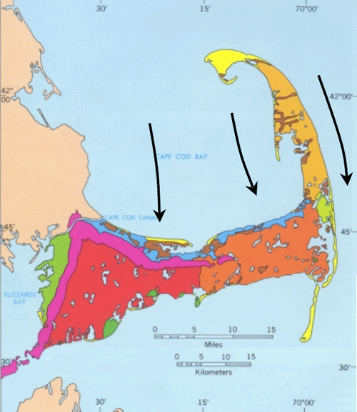
This map from the USGS Woods Hole group shows the geology of Cape Cod. Magenta indicates glacial moraines containing till, and green shows other deposits formed in contact with ice. Oranges and red are outwash plains. Blue marks deposits from a lake that formed when the ice began melting back from the Cape but still plugged Cape Cod Bay and kept the ocean out. Brown shows marsh deposits, and yellow shows new sand deposits. We added the black arrows to show where the ice flowed in the past.
Waves and Coasts
There are many types of coasts. North of the Cape at Acadia National Park, Maine, strong igneous and metamorphic rocks make sea cliffs. South, in the Virgin Islands National Park, are coral reefs. Built from the skeletons of millions of tiny animals, the reefs rise from the sea bottom and flourish in shallow, clear, sunlit, oxygenated waters far from sediment that would bury and choke them. Around into Louisiana, you remember the Delta National Wildlife Refuge, and the miles of waterfowl-filled wetlands on mud delivered by the Mississippi River. At Cape Cod, we find barrier beaches or barrier islands offshore of marshes, or we find sandy beaches with the bulk of the Cape just behind.
The type of coast depends on the supply of sediment to it, the wave energy, the tidal range, the type of rocks, and many other factors. Here, we will concentrate on the Cape Cod sandy beaches.
Watch a wave on the Cape, or any other sandy beach, and you will see that the wave moves a lot of sand. Dig a hole just above the water level during a rising tide, and within a few minutes the hole will be filled with wave-carried sand. Go to the beach during a big storm and you will see immense amounts of sand moved. Hundred-foot-high bluffs may be eroded back several feet, or layers of sand many feet thick may be added to the beach or eroded from it in hours. A movie at the Salt Pond Visitors Center includes a series of photos taken of one section of beach before and after a string of storms one winter. The summer beach is an unbroken expanse of sand, but boulders many feet across are buried in it, and were completely covered and uncovered several times during that one winter as the sand was moved on and off the beach.
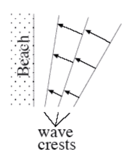
The energy for all of this comes from the wind driving waves, and to a lesser extent from the tides. Most of the sand transport is simply onshore and offshore with each wave—the sand is carried in as a wave comes in, and out as the wave goes out. Most transport is to and from the beach, rather than along the beach, because most waves turn so that their crests are almost parallel to the beach, and their water motion is almost directly towards and away from the beach. The turning happens because waves go slower in shallower water. If a wave approaches a beach at an angle, the first part to near the beach will slow down, allowing the rest of the wave still in deep water to nearly catch up, as shown in the diagram to the right.
Every wave moves sand up and down the beach. On even rather quiet days, if you sit down on a Cape Cod beach in shallow water, you soon will find that sand is piling in places around you, and being eroded in other places, and that you have sand in your swim suit, and possibly even in your hair. This in-and-out movement of the sand with every wave dominates the sand transport, allows for very efficient sorting of the sand by size, and serves to knock the sharp edges off sand grains, sea shells, old soda bottles, and other material on the beach.
Look out to sea during a winter storm, and you’ll see high-energy breakers coming at you. The white caps of the waves rise high, curl over and crash down, so that some of the water arrives on the beach after coming in through the air rather than washing along the sand. But the water then rushes back toward the ocean along the sand, carrying some sand seaward. There thus often is a little net movement of sand from the beach into slightly deeper water during storms, which are more common during winter than during summer. This transport may remove enough sand to lower the beach many feet or tens of feet during the winter, exposing buried boulders. The waves of summer are on average lower in energy, and don’t break and travel through the air as much (occasional hurricanes change this story, but most of the time the story is fairly accurate). The surge of summer waves up the beach is slightly faster than the return flow down the beach, and may carry a tiny bit more sand up than back; the net effect is to bring sand from just offshore back to the beach, burying any beach boulders that were exposed during the winter.
But, the incoming waves do not turn quite enough to come straight in, as shown in the diagram—they still have some angle. If you ride the waves in, swim out, ride in, swim out, ride in... after a while you will find you have drifted down the beach away from the lifeguard—even though you were mostly going toward the beach and back out to sea, the waves also were pushing you sideways. In such a situation, we say that you are experiencing longshore drift—you, and the water, and sand, are moving along the shore. Eventually, when the water and sand reach the end of the Cape (at the Provincelands to the north, or Monomoy to the south), some of the sand builds a spit or extension of land, but some of the sand is dumped off into deeper water beyond the reach of waves. This sand is then lost from the Cape, and the Cape has gotten a little smaller. Most references say that the great beach facing the Atlantic is retreating at about 3 feet (1 m) per year, although it may have been a little faster recently, and the panicked light-house rescues were required because retreat for a few years was much faster. We’ll look at these issues, and what might be done, after visiting Acadia in the next chapter.