INCISED MEANDERS AND GEOLOGIC HISTORY
Canyonlands poses a special puzzle. The rivers in Canyonlands meander, making big, sweeping curves through the red rocks. In the Canyonlands chapter, you read that meandering streams occur in flat, lowland regions lacking supply of big rocks to the stream. This is decidedly not the situation in Canyonlands. The streams are steep, and in places (although not just where the picture below was taken) are laden with rapids, challenging for whitewater rafters. Landslides and rockfalls from the canyon walls deliver large blocks to the streams.
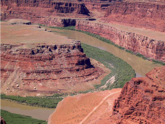
The likely story is that the streams once flowed across nearly flat lowlands. Then, uplift of the rocks began, giving the streams a steeper slope to the sea and so speeding their flow and causing them to erode. But, the uplift was gradual enough that the streams held their old courses. The streams cut downward without a change in pattern, which is called incision. Canyonlands contains clear examples of incised meanders. Similar features are preserved throughout the Colorado Plateau, documenting widespread uplift of the Plateau.
Much of geology involves study such as this; the history of a region produced the modern features. One can often learn much about that history by understanding the modern features and how they were formed. Clearly, if we did not know what conditions produce meandering streams today, we would not know what conditions likely occurred in the past when the meandering streams developed. The geological saying that captures this idea is “The present is the key to the past.”
SINKING MUD
Down at the Mississippi Delta, we saw that the mud under New Orleans is compacting under its own weight, contributing to sinking of the city. A couple of other things also contribute to the sinking.
As the delta grows, the weight of the mud pushes down the rock beneath, with soft, hot rock much farther below flowing away laterally, like water under your behind if you sit on a water bed. The sinking is not instantaneous. And, just as the strength of the water-bed cover spreads the dimple around your behind when you sit down, a fairly large region around the delta is pushed down by the weight of the delta. So add some mud anywhere near New Orleans, and you get a little sinking in New Orleans for a while.
Perhaps more importantly, as we saw with mass movements at the Grand Tetons (and as you can see in the picture of Canyonlands on the previous page, in the cliff on the inside of the meander), rocks tend to fall off steep slopes. Sometimes a single rock falls, or a thin layer of rocks slides. Other times, large thicknesses of material move. The Mississippi Delta is a giant pile of mud towering above the deep waters of the Gulf of Mexico, and that “cliff” is subject to downward motion of its materials. Some of this occurs along faults that are something like pull-apart Death-Valley-type faults—the fault intersects the Earth’s surface well inland, sloping down toward the Gulf, and the mud on top slides down and toward the Gulf.
After Hurricane Katrina devastated New Orleans, geologists renewed their efforts to understand what is going on geologically—such understanding should help in planning how to slow down the next disaster. An argument has erupted about the relative importance of the various reasons for sinking in and near New Orleans, with faulting probably more important (and mud compaction less important) than previously believed, and with sinking of the rock beneath minor but not zero. All are almost certainly contributing, but with a little work to figure out just how much to blame on each one. Naturally, all of them contributed to lowering of the surface, and sediment deposited from the river's floods filled that space—the river doesn't really care why the surface dropped, and deposits sediment in low places formed by any process.