Coasts & Sea-level Changes (Cape Cod & Acadia)
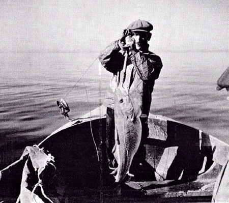
The cod has been an extremely valuable resource for several centuries in Massachusetts. Its extensive use as a food dates back to the earliest period of European settlement in coastal New England. In colonial times, it was deemed so important that in 1693 the General Court of the Massachusetts Bay Colony ordered that farmers could no longer use cod as fertilizer. This action was one of the first recorded attempts at natural resource conservation and management on this continent.
Although one of the earliest fisheries resources to be broadly utilized after European settlement in New England, cod populations along the US coast proved to be very resilient. Cod apparently withstood more than 3 centuries of harvest without displaying major, long-term regulations in abundance. However, mid-twentieth century advances in fishing technology and the introduction into the northwest Atlantic of distant-water foreign fishing fleets during the late 1950's led to a period of reduced abundance and major annual fluctuations in population size. During the mid-1980s commercial vessels captured mostly 3 to 5 year old fish, indicating that few larger, older individuals remain along the North American coast.
—From the Massachusetts Division of Marine Fisheries
Will Cape Cod be there in the future? Looking out a few millennia, the answer is probably "no." Beaches, like rivers, are interplay of water and sediment. Sand is supplied, and sand is lost. Interrupt this process, and the coast must change. And in the distant future, Cape Cod is likely to be the new Georges Bank, an underwater place that could be home to great masses of fish, if we leave enough fish to get along and get it on.
What to do for Unit 8?
You will have one week to complete Unit 8. See the course calendar for specific due dates.
As you work your way through the online materials for Unit 8, you will encounter a video lecture, several vTrips, some animated diagrams (called GeoMations and GeoClips), additional reading assignments, a practice quiz, a "RockOn" quiz, and a "StudentsSpeak" Survey. The chart below provides an overview of the requirements for this unit.
| REQUIREMENTS | SUBMITTED FOR GRADING? |
|---|---|
| Read/view all of the Instructional Materials | No, but you will be tested on all of the material found in the Unit 8 Instructional Materials. |
| Submit Exercise #4: Which Way is Up? | Yes, this is the fourth of 6 Exercises and is worth 5% of your total grade. Please see the course calendar for specific open and close dates and times. |
| Begin Exercise #5: Puzzling Out Relative Time | Yes, this is the fifth of 6 Exercises and is worth 5% of your total grade. |
| Take the Unit 8 "RockOn" quiz | Yes, this is the eighth of 12 end-of-unit RockOn quizzes and is worth 4.5% of your total grade. |
| Complete the "StudentsSpeak #9" survey | Yes, this is the ninth of 12 weekly surveys and is worth 1% of your total grade. |
Questions?
Please feel free to email "All Teachers" and "All Teaching Assistants" through Canvas conversations with any questions.
Keep Reading!
Students who register for this Penn State course gain access to assignment and instructor feedback, and earn academic credit. Information about registering for this course is available from the Office of the University Registrar.