Unit 3: Mountain Building and Volcanism
Welcome to Unit 3
Introducing Mountain Building & Volcanism (Volcanoes!)
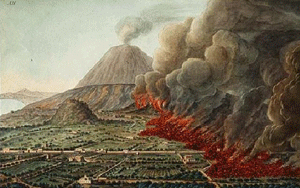
They tied pillows on top of their heads as protection against the shower of rock. It was daylight now elsewhere in the world, but there the darkness was darker and thicker than any night…(t)hen came a smell of sulfur, announcing the flames, and the flames themselves…he stood up, and immediately collapsed…his breathing was obstructed by the dust-laden air.
—Account by Pliny the Younger of the death of Pliny the Elder in the eruption of Mount Vesuvius in A.D. 79 that destroyed Pompeii and Herculaneum in Italy. [Living with a volcano in your backyard: an educator's guide with emphasis on Mount Rainier [1]]
Supposedly, Atlantis was an island civilization "outside the Pillars of Hercules" and thus located in the Atlantic Ocean, where it was destroyed by an earthquake or tsunami (giant wave) about 11,000 years ago. The source of this information (according to Wikipedia) is an account that Plato wrote in 360 BC of information reportedly given to Solon two hundred years earlier by priests he visited in Egypt. Now, if someone told you that 200 years ago someone else had received information by yet another person regarding something that happened 9000 years earlier, would you immediately believe it? A lot of people apparently do; a search of Google for "Atlantis Plato" finds about 327,000 2.8 million matches, and not all of them are academic discussions.
A better question might be whether there really are islands that disappear below the sea. The answer is yes; many do. Some slide slowly downhill, at about the same rate as your fingernails grow, and disappear first beneath the waves and finally beneath the continents. Others suddenly explode, scattering themselves across the world.
Before we go any further, take a look at the following short video introduction by Dr. Anandakrishnan...
Hey, groovy cats. Welcome to my pad. This is the G-Side 10 '70s show, in which we're going to talk about vinyl, bell-bottoms, platform boots, and most importantly, lava lamps.
What? You mean you don't have a lava lamp? Run down to Uncle Eli's right now and get one. I'll wait.
So what do lava lamps and G-Side 10 have to do with each other? Well, they're a wonderful analog for this whole first section of G-Side 10. First section, if you remember from looking at the syllabus, is building mountains. And the short story for building mountains is heat from within the Earth.
We're going to talk about tearing down mountains later on, but right now we're talking about building mountains, and the heat within the Earth is what drives that whole process. And a lava lamp is a beautiful example of that. Let's take a look at it.
What we have here is a glass tube with some water in it, and then these globules of a slightly different material, and at the bottom, we just have a light bulb that produces heat and heats up the bottom of this glass bowl.
All right, I'm going to take this apart here, and just take a look on the inside. I don't know if this is going to be too bright for you, but we have a light bulb underneath here, and its only purpose is to produce heat and to light up this glass bulb a little bit.
These green globules in here get heated up at the bottom, and as they get heated up, they get less dense. This is fundamentally what's happening inside the Earth. Rocks get heated up at depth, because there's a lot of heat trapped inside the Earth. As they get heated up, they get less dense, and just like these lava lamp globules, they rise up like this one's doing right now, up to the surface of the Earth.
When they get to the surface they cool off, and then, just like this one, they sink back down into the Earth and the whole process goes on and on again. This inside the Earth we would call a convection cell. In a lava lamp, we call it cool.
What to do for Unit 3?
You will have one week to complete Unit 3. See the course calendar for specific due dates.
As you work your way through the online materials for Unit 3, you will encounter a video lecture, several vTrips, some animated diagrams (called GeoMations and GeoClips), additional reading assignments, a practice quiz, a "RockOn" quiz, and a "StudentsSpeak" Survey. The chart below provides an overview of the requirements for this unit.
| REQUIREMENTS | SUBMITTED FOR GRADING? |
|---|---|
|
Read /view all of the Instructional Materials |
No, but you will be tested on all this material. |
| Submit Exercise #1: Scientific Literature | Yes, this is the first of 6 Exercises and is worth 5% of your total grade. |
| Begin Exercise #2: Geology is All Around You | Yes, this is the second of 6 Exercises and is worth 5% of your total grade. |
| Take the Unit 3 "RockOn" quiz | Yes, this is the second of 12 end of unit RockOn quizzes and is worth 4.5% of your total grade. |
| Complete the "StudentsSpeak #4" survey | Yes, this is the third of 12 weekly surveys and is worth 1% of your total grade. |
Questions?
If you have any questions, please feel free to email "All Teachers" and "All Teaching Assistants" through Canvas conversations.
Keep Reading!
On the following pages, you will find all of the information you need to successfully complete Unit 3, including the online textbook, a video lecture, several vTrips and animations, and two overview presentations.
Students who register for this Penn State course gain access to assignment and instructor feedback, and earn academic credit. Information about registering for this course is available from the Office of the University Registrar [4].
Main Topics, Unit 3
Overview of the main topics you will encounter in Unit 3
PLATE TECTONICS II
- Most students find this week to have more new material than any other.
- We always debate how much time to spend on the “science,” “impacts,” and “cute critter” material.
- We usually work fast through the deep-earth and tectonics parts to get to the cute-critter and living-on-Earth parts.
- So suck it up and power through, and things should get easier.
SUBDUCTION
- We saw that the sea floor is made at spreading ridges, such as the one through the Gulf of California that almost reaches Death Valley.
- Sea floor is basalt—just what you’d get if you melted a little bit of mantle rock, and let the melt rise to the top and freeze.
- Although sea floor is generally less dense than mantle, very old, cold sea floor can be dense enough to sink into hot mantle.
- As sea floor is made, Earth does not blow up like a balloon, so sea floor must be lost somewhere.
- Sea floor is lost where it sinks back into the mantle at Subduction Zones. All sorts of things happen there:
- Moving rocks stick, then slip, giving earthquakes;
- As the rocks go down, they are squeezed until the arrangement of atoms in the minerals changes to one that takes up less space; sometimes this rearrangement affects a lot of rock at once, giving an “implosion” earthquake (the deepest quakes may be of this type);
- Mud and rocks and even islands are scraped off the down going slab, piling up like groceries at the end of a check-out conveyor belt (that’s what makes up Olympic National Park);
- Some mud and rock are carried down a bit and then squeezed back out, something like squeezing a watermelon seed between your fingers until it squirts out (you may find some of this squeeze-back-out stuff at Olympic, too);
- Some mud and water are carried even farther down; the water lowers the melting point of the rocks (just as adding water to flour speeds cooking in the oven);
- And a little melt is generated, rises, and feeds volcanoes (Crater Lake, Mt. St. Helens, etc.) that form lines or arcs at continent edges or offshore;
- This melt is richer in silica and poorer in iron than the basalt it comes from, and is called andesite, because the volcanoes in the Andes were formed this way.
A BIT OF REVIEW
- Earth is hot, soft and convecting deep (asthenosphere); colder, harder and breaks in the upper mantle and crust (lithosphere) that are floating on top.
- Lithosphere is broken into a few big plates and many little ones; most “action” is at plate edges.
- Plates pull apart at spreading centers, splitting continents to make basaltic sea floor.
- Plates come together at subduction zones, where cold sea floor is dense enough to sink into hot mantle, where scraped-off materials pile up to make edges of continents (Olympic, etc.), and where water and sediment taken down lower melting point of rock, feeding silica-rich (andesitic) volcanoes.
- Plates also may slide past at transform faults, such as San Andreas.
- Stick-slip of moving rocks makes earthquakes; in subduction zones, collapse of minerals under rising pressure may make very deep quakes.
INTRODUCING VOLCANOES
- Towers of rising rock from very deep (often core-mantle boundary) feed “hot spots.”
- Plates drift over the top, and hot spots occasionally punch through to make lines of volcanoes, which often are oceanic islands (seamounts).
- Hotspots are from the mantle, basaltic, very similar to sea floor.
- A new hotspot looks like a mushroom when rising; the head feeds huge (state-sized) lava flows called flood basalts, and the stem then feeds the lines of volcanoes.
- Hawaii is the classic example.
- Yellowstone also a hot spot; the head of Yellowstone hot spot covered eastern Washington and Oregon with basalt, but Yellowstone's lava is modified coming through the crust so that more silica is erupted than for Hawaii.
VOLCANO CHARACTERISTICS
- In melted rock, silicon and oxygen make SiO4 tetrahedra that try to polymerize (stick together in chains, sheets, etc.) to make lumps;
- Can break up lumps with great heat and much iron (in basalt); makes lavas that flow easily and don’t explode, so Hawaii is a shield volcano, much wider than high;
- Can break up lumps with volatiles (water, CO2, etc.), but when these escape near the surface, lava won’t flow easily and plugs the system, so the next time trapped volatiles explode; form steep stratovolcanoes with alternating flows and pyroclastics (blown-up bits) from explosions.
VOLCANIC HAZARDS
- Include pyroclastic flows, deadly hot, fast rock-gas mixes;
- And pyroclastics, big rocks that fall on your head, or smaller ones that plug up jet engines;
- Also, poison gases, that kill many very quickly;
- And landslides and mudflows, that bury whole cities;
- Tsunamis, giant waves that devastate coasts;
- Climate change, especially cooling from particles blocking the sun and frosting crops;
- Hazards especially dangerous from subduction-zone volcanoes; Hawaii flows mostly block roads and burn houses, usually out-runnable.
PREDICTING VOLCANOES
- Easy to figure out where they are likely;
- Often, but not always, possible to figure out that an eruption will happen in next days or hours;
- Predictions are valuable and have saved many lives, but are imperfect;
- And people get mad if you tell them to leave and then nothing happens;
- United States Geological Survey especially handles predictions in US; highly valuable, and greatly under-appreciated;
- Lots of people continue to build and live where dangers await.
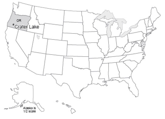
Textbook 3.1: More Plate Tectonics, Crater Lake
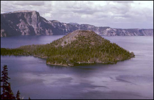
Crater Lake, at 1932 feet (about 600 m) deep, is the deepest and probably the cleanest lake in the United States, and surely among the most beautiful. Crater Lake sits in a great volcanic crater or caldera, 5 miles (8 km) across, formed when Mt. Mazama experienced a cataclysmic eruption about 6600 years ago. That massive eruption laid down ash that is 200-300 feet thick (almost 100 m) on the flanks of the volcano; the ash forms a recognizable layer hundreds of miles away in Yellowstone, and has been identified in Greenland ice cores.
The peak of the volcano had risen more than a mile above its mile-high base on the highlands of southwestern Oregon, but the great eruption removed about 4000 feet (1200 m) from the mountain’s height. About 16 cubic miles (40 cubic km) of rock were blown away. Glaciers had flowed down from the mountain peak; today, the glacial valleys can be followed upward until they disappear at the caldera rim. Although 50 feet (15 m) of snow falls in a typical year now, melting in the summer is sufficient to remove all this snow, and no glaciers exist. A tongue-in-cheek Christmas celebration on Aug. 25 substitutes for the snowbound December event.
After the great eruption, lava flows began building Wizard Island. If the water were removed from the lake, you could see that Wizard Island is roughly 0.5 mile (0.8 km) high. No permanent streams feed into the lake; the great rainfall and snowfall in the crater are balanced by evaporation, and by seepage through the rocks and eventually out the sides of the volcano as springs. With no streams supplying sediment, the lake is exceptionally clear and clean. Aquatic moss receives enough sunlight to grow 425 feet (130 m) below the water surface. When trout were stocked in the lake, freshwater shrimp were stocked first because otherwise biologists feared that the trout would have nothing to eat.
We will discuss volcanoes soon. For now, note that Crater Lake sits atop one of a string of volcanic peaks: Lassen Volcanic National Park and Mt. Rainier National Park preserve other peaks in the Cascades range. Mt. St. Helens, Glacier Peak, and several others are protected federally. These peaks line up in a row, called a volcanic arc, parallel to the coast. A similar arc sits along much of Central America, and forms the Andes of South America. And similar arcs also occur as island chains—the Aleutians, Japan, and others. In fact, the Pacific Ocean is almost entirely encircled by such volcanic arcs, forming the “Ring of Fire”.
Ring of Fire
Sitting offshore of the Ring of Fire is a ring of trenches, which include the greatest depths of the ocean. The trenches parallel the arcs. Some trenches, which sit near continents, are nearly filled with sediments dumped off the continents, but other trenches are almost free of sediment and so have very deep water, to almost 7 miles (11 km) deep. (Figuring out depths often is complicated by sediment. The surface of Death Valley sits more than two miles lower than the adjacent peaks of the Sierra Nevada. But below the salt flats of Death Valley there are sediments as much as three miles thick, materials that were eroded off the tops of the peaks, so the valley has dropped by much more than three miles relative to the peaks.)
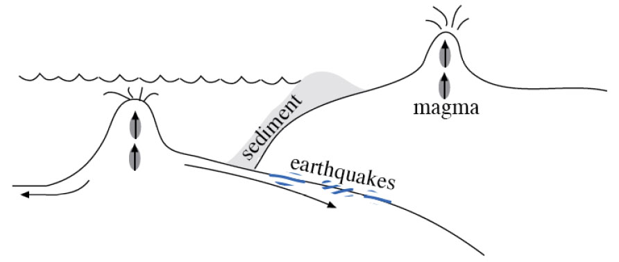
The trenches and volcanoes that ring the Pacific are clues to help solve a problem that might have been bothering you from last time. If the sea floor is made at spreading ridges and then moves away, where does it go? The earth is not getting bigger. (Well, meteorites are adding a tiny, tiny bit, but not nearly enough to account for sea-floor spreading.) So, the sea floor must be disappearing somewhere. The oldest sea floor we know of is only about 160 million years old, but the continents contain rocks as old as almost 4 billion years, suggesting that the sea floor is being consumed before it gets very old. (Remember, before the class ends, we’ll discuss how geologists date rocks.) (And remember that when a geologist dates a rock, it involves physics or chemistry but not dinner or a movie.)
Now, a few more clues. Sea floor is made of basalt. This is just the kind of rock that would be made if you melted a little bit of the deep, convecting rocks of the Earth’s mantle, and let that melt float up to the surface and “freeze” (cool until it solidifies). If you take basalt, a little ocean sediment, and some ocean water, and heat them enough to cause a little melting, let that melt come to the surface and freeze, you obtain a rock called andesite with a little more silica and a little less iron and magnesium than basalt, lighter in color and lower in density than basalt. Interestingly, the dominant rock in the walls of Crater Lake, and in the other Cascades and Ring-of-Fire volcanoes, is andesite (named after the Andes, which are part of the Ring of Fire).
If sea floor were plunging under the continents and melting to make andesite, you might expect that occasionally the down going rocks would get stuck and then break free, making earthquakes. Indeed, a three-dimensional map of earthquakes shows that shallow ones occur near the trenches, and the quakes are progressively deeper inland beneath the volcanic arcs. The great 1964 Alaska earthquake was such an earthquake, which happened where rocks of the Pacific Ocean floor plunge to the north under coastal Alaska and the Aleutian chain. The earthquakes there are shallow to the south and deepen to the north, along the down going rocks. The disastrous 2011 Tohoku earthquake in Japan was of the same type.
Careful work on the speed of earthquake waves, which is affected by the temperature of rocks, even provides a picture of cold slabs going down into the hotter mantle. As these down going slabs of rock are heated, with their water and sediment, a little melt is produced. (Interestingly, wet rocks melt at a lower temperature than do dry rocks, just as adding a little water to flour and yeast speeds cooking in the oven.) When the melt rises to the surface and cools, andesite forms, such as is seen around Crater Lake, in the Andes, or in the Aleutian volcanoes.
So, sea floor is made at the spreading ridges. It is hot and low-density initially, but cools and contracts as it gets older and loses heat to the colder ocean water. When the sea floor becomes cold and dense enough, it can sink back into the mantle, and we call the place where it sinks a “subduction zone”. The sinking sea-floor slab drags along a little sediment and water, warms up and melts a little of the slab and some of the sediment, and feeds the volcanic arcs. Old sea floor is going down around much of the Pacific Ocean, and in a few other places, such as beneath the Caribbean and beneath portions of the Alps. Wherever this happens, andesitic volcanic arcs form (see Figure 1).
Textbook 3.2: More Plate Tectonics, Olympic National Park
Grocery Shopping at Olympic National Park
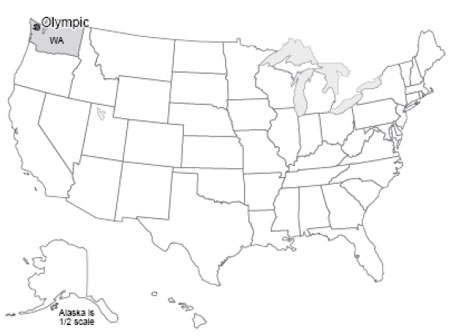
The Olympic Peninsula juts out into the Pacific Ocean, separated from Seattle by Puget Sound. Moisture-laden winds off the Pacific dump more rain and snow on the Olympic than anywhere else in the lower-48 United States. Great old-growth forest trees—Sitka spruce, Douglas fir, etc.—tower up to 300 feet (almost 100 m) above the forest duff, where butterflies flit past crystalline streams and cascading waterfalls. Along the coast, sea lions bask on offshore stacks, while urchins and starfish populate tidal pools. On the “high peaks,” numerous glaciers form and flow downhill. More snow accumulates than melts above about 6000 feet (2000 m). On most mountains, you have to go much higher to find summertime snow, but the huge winter snowfall on the Olympic allows the peaks to be snow-clad year-round despite rising less than 8000 feet (about 2500 m) above sea level.
Olympic National Park is a bit unusual in that it was established as much for biological reasons as for geological—to protect the Roosevelt elk that live on the peninsula. (The elk, named after Theodore Roosevelt, were critical in obtaining national monument status, which was signed by President Theodore Roosevelt. Later, the upgrade to national park status was signed by President F.D. Roosevelt. The Roosevelt elk is the largest of the elk subspecies in the country. Some consideration was given to naming the park Elk National Park before Olympic was chosen.)
The geologic story of the Olympic is somewhat shorter and less dramatic than for most of the national parks. The rocks of the Olympic are almost all young--less than 40 million years. (Again, please bear with us—we will justify these numbers before the course ends!) Before that, the coastline must have been farther to the east, perhaps in North Cascades National Park, and before that even farther east.
The Olympic Grocery
You’re standing at the grocery-store checkout. You put a bag of potato chips on the conveyor, and off they go, followed by a case of Pepsi, three loaves of bread, a watermelon, a box of Ho-Hos, and a sack of potatoes. Then, you realize that there is no bagger working, and that everything is piled up at the end, in a BIG mess. That mess is a good model for the Olympic Peninsula, and the whole coast from there up to Alaska.
The rocks of the Olympic Peninsula are a mixture of sea-floor basalts and of the sorts of sediments that accumulate today off the coast and fill the trench there. Rivers draining the peninsula, and much of the West Coast, carry great loads of sediment down to the ocean. Much of that sediment piles onto sea floor that is slowly moving beneath the continent, a conveyor belt that tries to pull the sediment down to melt and be erupted. Most of those sediments are “scraped off” on the way down, just as at the grocery store. The Olympic Peninsula is the off scrapings. Most of the rocks have been bent and twisted from the attempt to shove them under the continent (think of the potato chips after the Pepsi hits them!). Some of the Olympic rocks have been heated a good bit—the conveyor belt took them down a ways, but they then were squeezed back out.
Our emerging picture of plate tectonics is that the earth is heated inside, softening the deep rocks of the asthenosphere enough that they can move in great, slow convection currents that transfer heat from deep in the earth to near the surface. Heat is conducted through the upper rocks, or is erupted through them by volcanoes, and eventually is lost to space. But, the upper rocks in most places are cold enough that they tend to break rather than flow—they are brittle. These brittle rocks form the lithosphere, which includes the crust and the uppermost mantle. The rocks of the crust in continents are rich in silica (often like andesite in composition), making them light in color and low in density, so that they float on the deeper rocks and are rafted around on them by the moving convection currents. The sea floor rocks in the crust fall between the continents and the mantle in composition, and typically are basalt. The sea-floor rocks are usually intermediate between continents and mantle in density as well, but if the sea-floor rocks are cold enough, they will be slightly denser than hot mantle. Then, the sea-floor lithosphere consisting of the sea-floor crust plus a little attached mantle will sink into the asthenosphere of the deeper mantle.
The lithosphere is broken into a few big rafts, called plates—eight big ones plus some smaller ones, depending a little on how you define “big” and “small”—that float around on the convection cells below. Plate boundaries include spreading ridges where the plates move apart (remember Death Valley and the mid-ocean ridges), and subduction zones where the plates come together and one side sinks under the other. You might imagine that if plates can come together or pull apart, they must be able to slide past each other as well, which is what happens at the San Andreas Fault in California (we met it when we were discussing earthquakes); such slide-past boundaries are often called transform boundaries or transform faults (see Figure 1). You might worry that sometime, two continents would run together; we’ll meet that soon when we visit the Great Smoky Mountains.
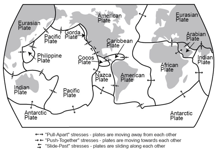
Plates shown are as follows:
- Eurasian Plate
- Indian Plate
- Antarctic Plate
- Pacific Plate
- Philippine Plate
- Gorda Plate
- Cocos Plate
- Nazca Plate
- Caribbean Plate
- American Plate
- Arabian Plate
- African Plate
The lithosphere and asthenosphere are solids, but a little melted rock may occur in the asthenosphere, and leak out where plates are pulled apart, feeding basaltic volcanoes. And the water taken down subduction zones can stimulate a little melting, feeding andesitic volcanoes that line up in arcs above the downgoing slabs of the subduction zones; examples of these volcanic arcs include the Cascades, Aleutians, and Andes. Continents are a collection of scum from melting of the mantle, too low in density to sink back into the mantle. Continents grow as the conveyor belt from the mid-ocean ridge to the subduction zone brings in sediments and islands and what-not, or when andesitic volcanoes are erupted on continents, or when andesitic volcanoes form an arc offshore that then collides with a continent (sometimes the site of subduction moves, and the volcanoes find themselves on the conveyor belt, or they hit a different continent). Because much of the sediment comes from the continents themselves, the growth of continents is not fast—material eroded from the continents falls on the conveyor and is added back at Olympic or erupted back at Crater Lake.
Textbook 3.3: More Plate Tectonics, Mt. St. Helens
Mt. St. Helens & Volcanic Hazards; More to Worry About
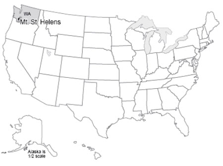
Mt. St. Helens, in southwestern Washington, was in some ways the queen of the Cascades Range. Beautifully symmetric, snow-capped, it had been called the Fujiyama of the Pacific Northwest. Scores of people flocked to St. Helens’ flanks to hike, camp, ski, and generally enjoy the environment. And all that changed in 1980.
Mt. St. Helens has also been the most active of the Cascades volcanoes over the most recent centuries. In early 1980, the volcano clearly was “waking up”. Earthquakes shook it almost continuously, including special “harmonic tremors”, similar to those sometimes caused by fluid flow in pipes, which showed that liquid rock was moving up from below. Small eruptions occurred, and hot springs and fumaroles (steam or gas vents) became increasingly active. The north side of the mountain was bulging, blowing up like a balloon as the magma moved into it. Scientists were scrambling to study the volcano, and predict its course. They recommended evacuation for safety, and most people (but not all, including some scientists) were moved out of the way. Penn State professor Barry Voight warned that the huge bulge on the north side of the volcano would fail, unleashing a giant landslide and a devastating eruption.
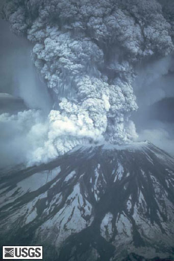
On the morning of May 18, 1980, Professor Voight’s prediction came frighteningly, awesomely true. The bulge failed. A large earthquake either caused, or was caused by, failure of the north side of the mountain in a giant landslide. Like pulling the cap off a hot, well-shaken soda bottle, the liquid beneath flashed into froth, driving an eruption 12 miles (20 km) high. A shock wave knocked over full-grown trees in an area 20 x 10 miles (32 x 16 km). The landslide eventually poured more than 100 million cubic yards of rock material down the Toutle and Cowlitz Rivers, raising the floor of the North Fork of the Toutle as much as 600 feet (200 m), and sweeping roads and houses downstream, with the debris reaching and clogging the shipping channels of the Columbia River. The Toutle floor now sat higher than the smaller streams that fed it, and lakes began to form; only quick work by the Army Corps of Engineers prevented those lakes from overtopping the mud damming them, cutting quickly down through it and releasing further floods.
All told, the Corps of Engineers spent $250 million clearing shipping channels and doing other critical work. Approximately 60 people were killed in the blast and landslide; some were buried under hundreds of feet of steaming mud and their bodies were never recovered.
President Jimmy Carter scowled at the disaster from a helicopter. Disaster planners pontificated. And in the shadows of the other Cascades volcanoes, people continued building houses in regions of known volcanic hazard.
The Mt. St. Helens Volcanic Memorial today has little in common with conditions pre-1980. The center of the volcano was more than 1/2 mile (nearly 1 km) lower after the eruption than before, with the missing rock spread over the surrounding countryside, forming a visible layer as far as 900 miles (1500 km) away. (Professor Alley and his wife Cindy were driving in Alberta, Canada during the summer of 1980, on a great, seven-week, see-the-national-parks-in-a-Chevette-with-a-tent honeymoon. A secondary eruption of Mt. St. Helens put enough ash in the air to halt traffic because of reduced visibility, hundreds of miles from the volcano.) Many of the trees knocked over by the blast still lie there—hundred-foot-long toothpicks pointing in the direction of the searing winds of the blast. Among these dead trees, however, salmonberry and fireweed and young firs are pushing skyward, elk are grazing, and coyotes search for rodents. In some places, salvage-logging of the downed trees was allowed. In some of those places, it appears that erosion has run amok, large gullies have developed, and the return of vegetation has been greatly slowed. In the crater of the volcano, a new lava dome is forming, squeezing slowly upwards like toothpaste from a very hot tube, and amazingly, a glacier sits behind it, fed by the great snowfall and the avalanches down into the crater. At night, the dome glows dull red. (It may seem weird that we focus on an event from before most of you were born, from 1980, when larger eruptions have happened more recently. But, St. Helens is the largest recent eruption in the lower-48 of the US, the easiest eruption site to get to and observe, and it really is awesome. The elder Alley daughter, Janet, was a ranger there one summer, and recommends that you take in Ape Cave if you visit, but the real goal is to see just how immense the eruption's effects really were.)
Types of Volcanoes
Volcanoes occur where melted rock rises to the Earth’s surface. Almost all volcanoes are associated with one of three settings—pull-apart margins (spreading ridges), push-together subduction zones, and hot spots. We’ve already met the volcanoes at spreading ridges, where low-silica basalt is erupted, and those producing higher-silica andesite at subduction zones.
Hot spots are creatures of another type in the zoo of Earth’s features, and especially interesting creatures at that. Deep in the warm, soft, convecting mantle of the planet, in some places a rising tower of hot rock forms and then lasts for quite a while. Some of these rising towers may come all the way from the base of the mantle where it meets the core; others may start shallower. (To see something that looks vaguely like the formation of such a hot spot, go back and view again the “lava lamp” film of Dr. Anandakrishnan in the introductory material to this unit.)
As the lithosphere drifts overhead, the hot spot may “punch through” to make a volcano. Then as the lithosphere carries that volcano away, the hot spot punches through a new place to make a new volcano. Rising melt behaves a little bit like people driving cars, who use one road or the other but not the lawn in-between; hot spots often make a string of separate volcanoes rather than a continuous line or ridge, by coming up through one hole in the lithosphere for a while and then switching to a different one. Hot spots bring melt from deep in the mantle, and so normally make basaltic volcanoes (it takes fairly subtle and sophisticated chemistry to tell the difference between hot-spot basalt and sea-floor basalt from spreading ridges). However, where a hot spot pokes through a continent rather than through sea floor, silica from the continental rocks may mix with the melt to increase its silica content, as at Yellowstone.
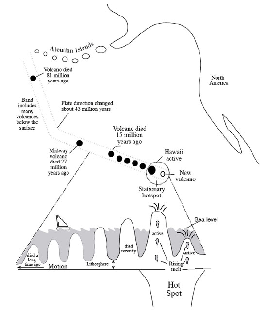
When a new hot-spot first rises from below, the top must push through the mantle and crust, and the resistance of the stuff in the way of the rising column causes its top to spread out like the head of a thunderhead, or of a mushroom cloud from an atomic bomb, or of a blob in a lava lamp, and for the same reasons. When that wide head reaches the surface, immense lava flows can be produced that spread across state-sized areas and bury them hundreds of feet deep. Much of central and eastern Washington and Oregon is buried by the “flood basalts” from the head of the Yellowstone hotspot. As the continent has moved across the hot spot after it reached the surface, a string of volcanoes erupted, including Craters of the Moon National Monument in Idaho. The hot spot now fuels Yellowstone (which is why it is called the Yellowstone hot spot…a lot of this stuff isn’t that difficult!).
The flood basalts from the Hawaiian hot spot have been subducted beneath the Aleutians, but the string of volcanoes that has formed since from the hot spot can be traced from the Aleutians south all the way to the volcanically active big island of Hawaii. A new volcano, Loihi Seamount, is growing undersea just off Hawaii as the big island slowly drifts away, and Loihi will someday (not in our lifetimes!) be the new, volcanically active “big island” while the volcanoes of the current big island die and the island slowly erodes away.
So, melt can leak up from below to feed volcanoes at spreading ridges, at hot spots, and above subduction zones. But very different volcanoes develop: sea floor from spreading ridges; flood basalts and then wide, not-very-steep Hawaii-shaped volcanoes from hot spots; and, steep Mt. St. Helens-type volcanoes above subduction zones. The type of volcano that develops at a place depends on a host of factors: temperature, composition, supply of melt, duration of supply, and several others. We will focus on two: composition (how much silica) and volatile content (mostly how much water, although carbon dioxide, hydrogen sulfide, and other compounds that are gaseous under earth-surface conditions may be present and classified with volatiles). Silicon and oxygen get together in melt to form the material we call silica. Left to itself, each silicon atom will be surrounded by four oxygen atoms, which form a tetrahedron (a little pyramid). But, give them a little time, and the tetrahedra will start sticking together, or polymerizing, into chains and sheets and bigger clumps, with some oxygens serving in more than one tetrahedron. If these lumps get big enough, they are minerals and the melt has solidified.
When the lumps are present but not too big, the melt is like lumpy oatmeal—it doesn’t flow very well. There are three ways to get rid of the lumps: make the melt really hot; fill the melt with iron, magnesium and other elements that interfere with the tetrahedra polymerizing; or, fill the melt with volatiles that interfere with the tetrahedra polymerizing. When polymerization is low, the melt flows easily. Lava comes out of the volcano quietly, without making big explosions, and flows easily and far from the mouth of the volcano. In extreme cases, flows may be nearly horizontal and cover much of a state, as in the flood basalts. If the melt spreads almost as easily as flood basalts, the lava will have very slight slopes of only a few degrees, forming shield volcanoes (they look like a warrior’s shield lying on its side) such as Hawaii. Hawaiian lavas and flood basalts flow easily because they are hot and are high in iron and magnesium.
When volatiles remove the lumps, a different situation develops. This is because the volatiles will only stay in the melt under high pressure. Just as a bottling company can force CO2 into the water of a soft drink under high pressure, but the CO2 escapes as the pressure falls when you open the can, the water and CO2 and other volatiles stay in the melt under high pressure down in the Earth but escape when the melt gets close to the surface.
Silica-rich melts usually form with many volatiles. Remember that in subduction zones, wet sediment dragged down the trench releases water (and carbon dioxide and others) that promote melting. When the melt (called magma when it is in the Earth and lava when it reaches the surface) nears the surface, the lower pressure allows the volatiles to bubble off and escape into hot springs, geysers, etc. (Note that most of the fluids that come out of such hot springs are rainwater that has circulated down into the earth, but some of the fluids may be “juvenile” waters from the magma below.) Silica-rich, relatively cool lava that has lost its volatiles flows only with great difficulty. It may emerge from the volcano and flow a little ways as a very thick, slow-moving, steep flow. It may not even flow, but simply form a dome directly over the volcanic vent. And, it may “plug the system” when it solidifies. Then the stage may be set for a big explosion.
The next melt that rises in the volcano cannot follow the same path, because hardened lava above prevents escape. The gases are trapped, and pressure builds up. The volcano is like a hot, shaken pop bottle. If the top is removed, either by an opener (say, a landslide as in the case of Mt. St. Helens, or a crack opened by an earthquake) or just because the pressure becomes great enough to blow the top off, the sudden release allows the soda, or the magma, to come foaming out. A good champagne may fountain to many times the bottle’s height, and blast the cork across the room. A powerful volcano may blast ash higher than jet flight paths. The melt really does get foamy, and that foam hardens into little glass shards. The ash layer deposited by Mt. St. Helens, which stopped drivers hundreds of miles away, was mostly of such little glass shards, although torn-up bits of the former volcano were also included.
The andesitic volcanoes of the Ring of Fire are typically stratovolcanoes, formed of alternating layers of thick lava flows and of pyroclastics—things thrown through the air by the volcano. The steepness comes from the flows, which cannot get far from the vent. Some of the andesitic volcanoes, including the rebuilding Mt. St. Helens, include plug-dome elements, the oozing lava staying right above the vent.
So, the major volcanoes for our purposes are the quiet, basaltic shield volcanoes of hot spots, the quiet basaltic rift volcanoes of spreading ridges, and the steep, scenic, explosive, andesitic volcanoes of the Ring of Fire. Other types exist, notably cinder cones thrown up by typically minor eruptions tossing pyroclastics short distances. Also, hot spots or rifts trying to poke through continental rather than oceanic crust may produce explosive silica-rich volcanoes. But if you understand shields and stratovolcanoes, you will be a long way toward understanding volcanism.
Volcanic Hazards and Prediction
People who live near volcanoes should be worried about them. Volcanoes can do much damage. The volcanic-triggered landslide that buried Armero, Colombia in 1985, and the eruption of Mt. Pelee on the island of Martinique in the Caribbean in 1902, each killed about 30,000 people. Other volcanic disasters bring the human death toll to perhaps 200,000 over the last few centuries. Compared to war, disease, or even automobile accidents, this is not a terribly high toll; however, the 200,000 people directly involved almost certainly would have appreciated enough warning to get out of harm’s way. One of the goals of modern geology is to predict volcanic hazards and to save lives and property by doing so.
There are many hazards to worry about. These include:
- Pyroclastic flows. Often, a volcano will produce a dense mixture of ash and hot gases (up to 1500oF or 800oC, and including poisons such as hydrogen sulfide). This potentially deadly mix is either forced away from the volcano (the lateral blast released by the landslide on Mt. St. Helens) or forced upward to then collapse and flow under gravity, at speeds up to hundreds of miles (hundreds of km) per hour. The deaths on Martinique were caused by such a “glowing cloud” (nuee ardente in French, where the only survivor in the whole city of St. Pierre was a lone man locked in a heavily built prison.)
- Pyroclastics. If the heat and gases don’t get you, the rocks might. People have been killed by rocks up to car-sized or bigger, called bombs, that were thrown from volcanoes. Having a car-sized rock fall on your head from a great height is not recommended. Even fine-grained ash deposits may bury and kill nearby crops. Jet aircraft are endangered by flying into ash at high speeds. From 1980-1995, ash caused an estimated $200 million in damage to the 80 aircraft that flew into eruption clouds, mostly over the Pacific. Of those, seven lost engine power and came close to crashing. Improved monitoring of eruption clouds, to provide warnings and steer the airplanes into safer air, has greatly reduced damages since then. However, to avoid crashes from the 2010 eruption of Eyjafjallajökull in Iceland, literally millions of passengers were stranded in Europe and elsewhere as flights were suspended over weeks.
- Poisonous gases. Sometimes, a volcano will smother or poison victims without burning them up. Pompeii and Herculaneum, the cities entombed by the eruption of Vesuvius in the year 79, have proven to be archaeological treasures, but certainly would be considered tragedies by the many people killed there and by their relatives. The people apparently were killed before they were buried, and they were not “fried” by intense heat; they probably were killed by poisonous gases and then buried by falling ash. Lake Nyos in Cameroon rests in a volcanic crater. Volcanic CO2 feeds into the bottom of the lake, but the lake typically remains stratified and does not mix. The CO2 thus builds up in the deep waters. In 1986, the lake overturned, perhaps because a landslide from the crater wall temporarily mixed the water at one end. The escaping CO2 made a great fountain, filled the crater, and then flowed down outside the crater, killing about 1700 people through some combination of suffocation and poisoning. The lake now is re-stratified and building up CO2 again; schemes to vent the CO2 safely through a huge pipe are working, but additional work may be needed to prevent a repetition.
- Landslides and mudflows. These are less dramatic, but more dangerous cumulatively, than the explosive events. Most of the andesitic volcanoes are steep, and many are capped by very large glaciers. Mt. Rainier, for example, has 25 times as much glacier ice as Mt. St. Helens had, ready to melt and trigger mudflows after even a minor eruption. The tragedy at Armero arose from a minor eruption that triggered a big landslide. It is worth noting that Armero was built on a known, older debris-flow deposit.
- Tsunamis. A large undersea eruption may move a lot of water. This water movement may form into a tsunami, a long, low wave that moves very rapidly. When a tsunami nears a shore, the water “piles up” into a short, steep wave that may be 100 feet high. Such waves, which also can be caused by landslides or earthquakes, may affect coasts hundreds of miles (or kilometers) from the source. The largest eruption of historical times, that of Krakatau in Indonesia in 1883, killed thousands of people on neighboring islands in this way. The great Tohoku earthquake of 2011 in Japan made a tsunami that was over 130 feet high (40 m) at its worst, where it came ashore where people lived. We’ll look more at tsunamis soon.
- Climate change. A large volcanic eruption puts a lot of sulfur gases into the stratosphere, together with ash and other materials. The sulfur eventually forms sulfuric-acid droplets, which typically remain aloft for one to a few years before falling out across much or all of the planet. While they are aloft, the sulfuric-acid droplets block some of the sunlight, cooling the planet a little. This can produce killing frosts during normal growing seasons, leading to widespread starvation in sensitive regions. The Tambora eruption of 1815 is associated with the starvation “year without a summer” of 1816. Ice cores from Greenland, Antarctica and elsewhere record volcanic fallout (the ash and sulfuric acid are preserved in the ice) and the temperature (from certain indicators including the isotopic composition of the ice), and show that big eruptions typically are accompanied by a cooling of a good chunk of a degree for a year or two, with more cooling in some places and seasons, and less in others. This isn’t a huge change, but when one killing frost can cause starvation, it may be too much. If many volcanic eruptions occurred in a short period of time, it might produce major climate changes; however, volcanism doesn’t seem to get organized—there is no way for a volcano in Alaska to tell a volcano in Indonesia that it is time to erupt. (Volcanoes also release carbon dioxide, which tends to warm the climate, as we will see later in the course. However, not a lot of carbon dioxide comes out in one volcanic eruption. If all the world’s volcanoes started erupting a lot faster, maybe twice as fast as normal, enough carbon dioxide would be released in “only” a few hundred thousand years to start warming the world notably. Over really short time scales of years to centuries, more volcanism would cause more cool years, because the sun-blocking effect would be much bigger than the warming-from-carbon-dioxide effect. If you turned up volcanoes, you would get first cooling and then warming.)
Predicting Eruptions
So, we wish to predict when and where volcanoes will endanger people. Various things can be done. For problems such as climate change, the best we can do is to know that every few years or decades some region is likely to experience difficulties with crop production because of eruptions. The solutions are either to maintain a little excess food to feed those endangered people, or to ignore them and figure that some will starve to death. (Many other climate changes, including droughts, give us the same choice. Despite the apparent silliness—either we stockpile food and figure out how to distribute it to the needy, or we let people starve to death—it is surprising how often starving to death is the outcome.)
For tsunamis, an operational warning system now exists around the Pacific and in some other places. If a tsunami is detected, or if seismographs detect the shaking caused by a large earthquake, landslide, or volcanic eruption, warnings are relayed to coastal regions likely to be affected, in time to allow evacuation. Such a system is being assembled for the Indian Ocean following the tragic 2004 earthquake-generated tsunami that killed approximately 250,000 people.
One way to avoid volcanic hazards is to stay out of harm’s way. Geologists can map regions where large pyroclastic chunks have fallen, or where landslides have occurred, with great confidence. Using carbon dating of logs caught in debris flows, or tree-ring dating of those growing on landslides (just hang on; explanation of such things will come later), we can determine the recurrence interval—how often do such disasters happen? Today, whole subdivisions are being built around Mt. Rainier National Park in the growing Seattle-Tacoma region that have a danger of destruction by landslide many, many times higher than their danger of destruction by fire. Roughly 200,000 people work, and more than 100,000 people live, on debris-flow deposits less than 10,000 years old, with more people coming. The homeowners will all carry fire insurance, but few if any are insured against the volcano; presumably, if they survive the next volcanic disaster, these people are counting on disaster aid from the rest of the country to bail them out.
(Much argument is attached to sending disaster aid for predictable events, even if they are not very common. Should those who wish to live in beautiful but risky areas carry insurance to pay for their gambles? Increasingly, planners are saying “yes,” and much effort is being devoted to quantifying the hazards so that insurance rates can be set wisely. This applies to such things as hurricanes along coasts, earthquakes along faults, and floods along rivers. Geologists have an important role to play in learning hazards and thus setting rates.)
With sufficient care, volcanic eruptions can be predicted with some confidence. Volcanoes usually give off many signals before an eruption: the ground swells as magma moves up; the moving magma and the swelling ground create earthquakes and especially the distinctive harmonic tremors of fluid flowing in a pipe; small eruptions occur; gaseous emissions increase as the magma nears the surface and then cease if the system becomes plugged and builds up pressure for an explosion. A monitoring program of seismographs to detect earthquakes, repeat surveying of laser reflectors set on the mountain to watch for deformation patterns, gas sampling, and perhaps photographic or other sensors to watch for landslides, can track a volcano’s behavior and allow timely warning. Monitoring of ground shape from space can even see the changes in volcanoes as magma moves under them. The eruption of Mt. St. Helens was predicted well enough to save hundreds of people including the residents of a YMCA camp. The eruption of Mt. Pinatubo in the Philippines in 1991, which heavily damaged the U.S. military bases there, was predicted accurately, allowing timely evacuation and saving tens or hundreds of thousands of lives of residents and military personnel.
The burden of predicting eruptions is very high. Imagine telling an Air Force general to abandon his or her assigned duty post, spend a few hundred thousand dollars to move tens of thousands of people, and then having nothing happen—the general, and all of those people, would be very unhappy. Imagine instead deciding to wait another day to be sure, and having all of those people (possibly including you) killed. Important as this is, predicting disasters is not for the faint of heart.
The Mt. St. Helen’s eruption was a small one compared to many others. Each of the major eruptions of Yellowstone moved about 1000 times more material than Mt. St. Helens did, and Yellowstone’s eruptions were not the largest known. Small eruptions are more common than large ones. But, eruptions ten times as big as Mt. St. Helens are perhaps five times as rare, but not ten times as rare. This means that, as for earthquakes, most of the “work” done by volcanoes is achieved by the few big ones, not the many little ones.
Virtual Field Trips
Join Dr. Alley and his team as they take you on "virtual tours" of National Parks and other locations that illustrate some of the key ideas and concepts being covered in Unit 3.
TECH NOTE
Click on the first thumbnail below to begin the slideshow. To proceed to the next image, move the mouse over the picture until the "next" and "previous" buttons appear ON the image or simply use the arrow keys.Virtual Field Trip #1: Crater Lake
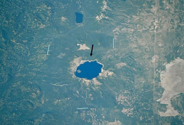
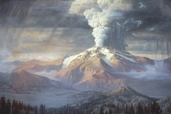
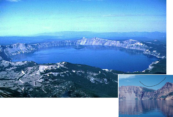
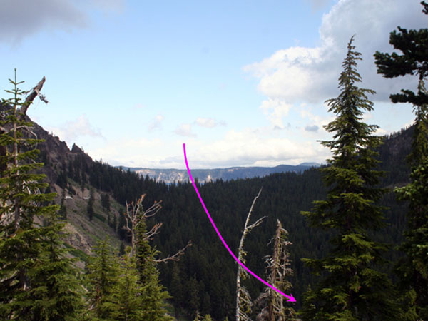
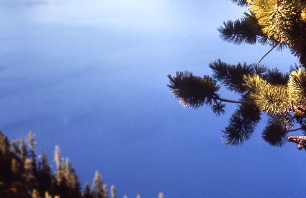
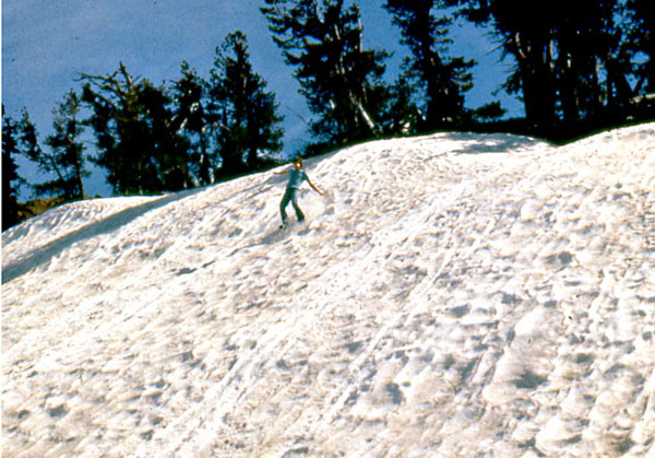
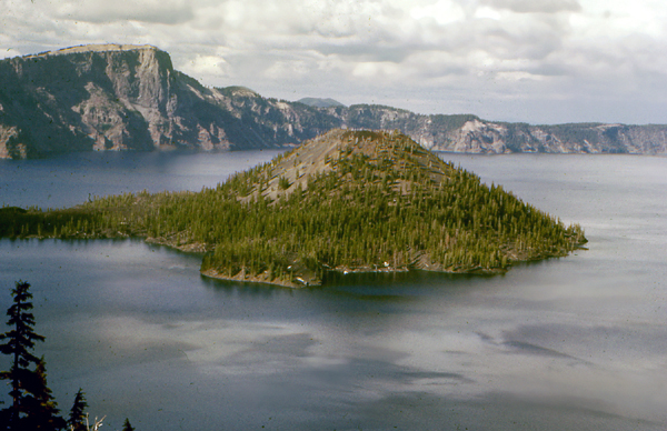
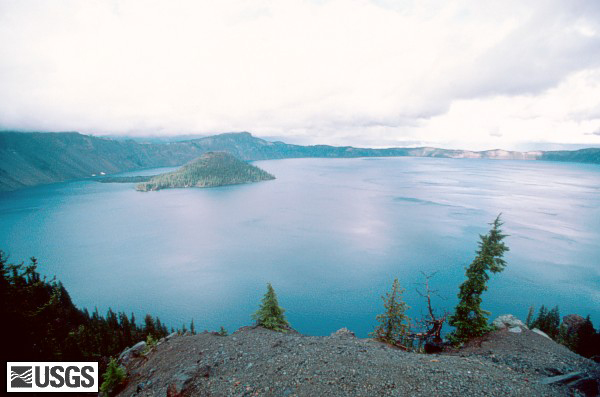
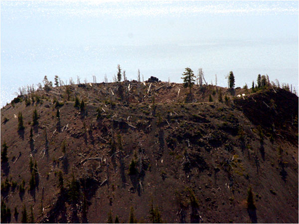
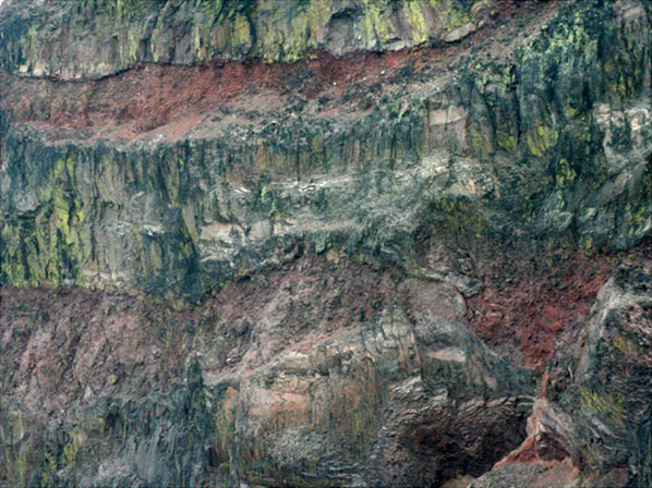

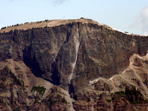
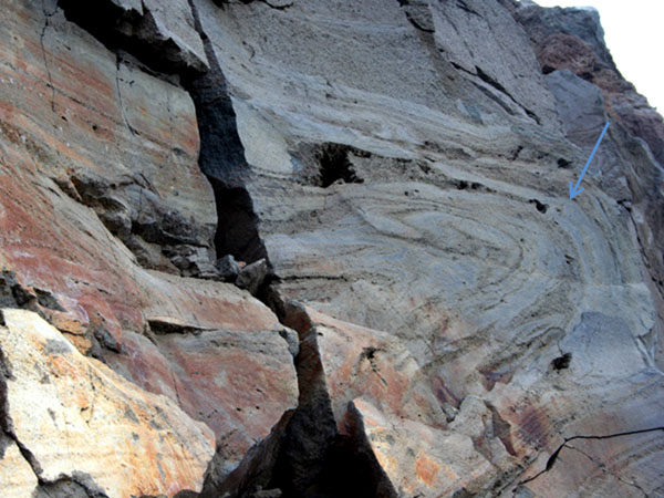
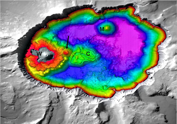
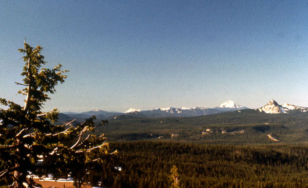
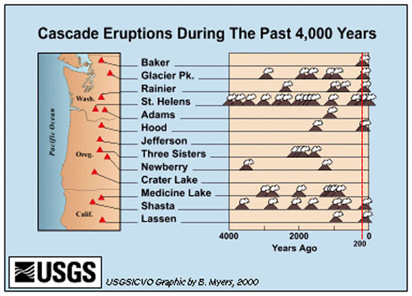
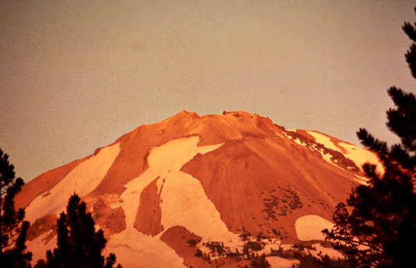
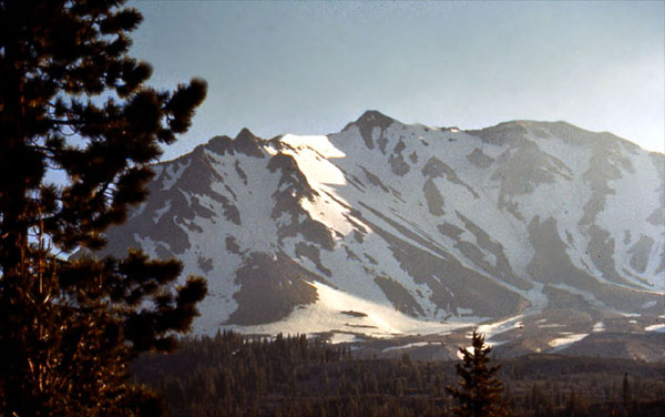
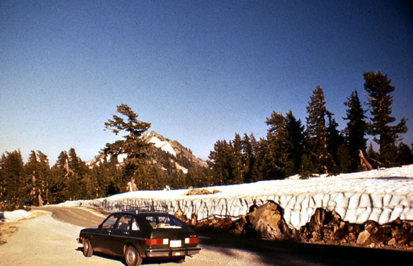
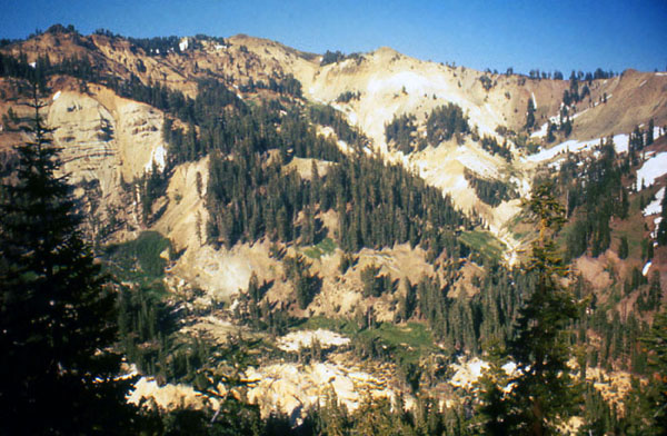
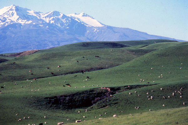
Image 1: A view of Crater Lake from the sky. Crater Lake, which is about 6 miles across, is the big blue circle in the middle of this satellite photograph. A catastrophic eruption from a towering, snow-capped volcano called Mt. Mazama blasted a recognizable layer as far as Nebraska. The remnants of the volcano then collapsed into the hole left behind. As the hole cooled and water collected, Crater Lake formed. This NASA photograph is from the USGS archives. Because logging and other uses continue outside the park but not in, careful examination will show you the outline of the park.
Image 2: Paul Rockwood’s painting of the cataclysmic eruption. Here is artist Paul Rockwood’s reconstruction of how the peak might have appeared 6600 years ago, early in the cataclysmic eruption. Notice the glaciers flowing down the sides. The USGS hosts this image courtesy of the Crater Lake Natural History Association.
Image 3: Two images. Top, an oblique aerial view of lake. Bottom, a close-up view of the lake. After the eruption, this USGS photo by W.E. Scott shows the lake in an oblique aerial view (out the window of a plane). On the right, a close-up view (USGS photo by Ed Klimasauskas) shows the “U”-shaped valley of a former glacier, which flowed down from the peak that is no longer there (the outline flying in the sky emphasizes the “U” shape). Later in the semester, we’ll learn why glaciers make “U”s while rivers make “V”s.
Image 4: Now, we begin some pictures by Prof. Alley. Here is a view looking up one of the valleys that once carried glaciers down from the peak of Mt. Mazama. If we had stood in the same place before the eruption, this whole picture would have been filled by a massive, snow-capped volcano, with a glacier flowing down the valley towards you and to your right, following the magenta arrow.
Image 5: This is Crater Lake from the rim of the crater. The trees are silhouetted against the water, it’s not sky! Crater Lake probably has the cleanest water of any major lake in the country.
Image 6: Another shot of trees against the crystal water of Crater Lake. There are no rivers to carry mud into the lake; the rivers all drain away down the sides of the volcano. Rain and snowmelt evaporate from the lake, or leak through the rocks to emerge as springs on the side of the volcano.
Image 7: A person sliding down a hill of snow at Crater Lake. Crater Lake gets lots of snow, which melts to fill the lake, and contributes to the fun at the park.
Image 8: Crater Lake with Wizard Island in the middle. After the cataclysmic eruption, additional volcanism began building Wizard Island, which rises about half a mile above the bottom of the lake.
Image 9: A wide angle view of Wizard Island in the Lake. Photo by Lyn Topinka.
Image 10: Top of Wizard Island showing the crater left by the “little” volcano that built the island. Zooming in, you can see the crater left by the “little” volcano that built Wizard Island. Although Wizard Island looks small in Crater Lake, and this crater is just a small part of Wizard Island, notice how big the crater is compared to the trees growing on it. How big something looks can sometimes be misleading!
Image 11: Layers of lava from Crater Lake. We call these big, steep volcanoes of the Cascades and the Ring of Fire “stratovolcanoes”, and say that they are made of layers of lava flows and pyroclastic pieces thrown in eruptions. But how do we know what a big volcano is made of inside? Drilling holes is expensive and provides a narrow window. Geophysicists can learn some things, and geologists can watch volcanoes growing or look where streams have eroded volcanoes. But here at Crater Lake, the insides of the volcano are laid bare. This picture is a telephoto shot of a piece of the cliff above the lake, showing lava flows and pyroclastic layers stacked a couple of hundred feet high. These are strata, and this is a stratovolcano.
Image 12: Llao Rock. Not too long before the cataclysmic eruption, a small eruption threw white pumice that covered the floor of a valley running down from the peak. Then, a big lava flow from the peak filled the valley, giving us what is now known as Llao Rock. The white arrow is pointing to the pumice, with Llao Rock outlined in black. Notice the wonderful layering in the volcanic rocks below the pumice, beside the big red “L”. The next picture is the same view, without the labels.
Image 13: Another picture of Llao Rock.
Image 14: Main lava fold visible in a road cut. Here’s one of the lava flows that make up Mt. Mazama, from before the cataclysmic eruption. You can see this one in a road cut on the southeast side of the lake, where the Rim Drive crosses Dutton Ridge. The thick, viscous lava didn’t flow easily, and some parts flowed faster than others, making the interesting folds that you see in the rock. The arrow points to the main fold—let your eye follow the layers at the end of the arrow, and you’ll see that the layers bend around. Looking carefully, you may see wiggles within the wiggles in the layering. We will see later that folds such as this are also found in metamorphic rocks, but the minerals and other things are quite different.
Image 15: Water depths at Crater Lake. Everything above the water is gray-white, all below is garishly colored, with red the shallowest water, then orange, yellow, green, blue, and on to purple/violet in the deepest water (to 1949 feet deep). Minor volcanic activity after the main eruption produced features, including Wizard Island (marked with a “W”), which sticks above the water. A later eruption produced lava flows (the Central Platform, “C”) coming from a small volcanic dome (at the end of the arrow). Another volcanic peak in the crater is evident below the water (Merriam Cone, marked “M”). From the USGS at http://craterlake.wr.usgs.gov/bathy_images.html [5]
Image 16: Dr. Alley's view from Crater Lake, looking along the Cascades Range of similarly explosive volcanoes.
Image 17: The history of eruptions of the main Cascades volcanoes of Washington, Oregon, and northern California over the last 4000 years, as compiled by the USGS. Each volcano icon indicates an eruption or closely spaced series of many eruptions. The record of written observations is especially good to the right of the red line on the far right, but use of tree-ring dating and other techniques makes all of this highly reliable.
Image 18: Lassen Peak, in Lassen Volcanic National Park of northern California. Lassen, shown here reflecting a beautiful sunset, erupted about a century ago. Lassen is quite similar to the other Cascades peaks, and remains capable of eruptions.
Image 19: Another view of Lassen Peak
Image 20: Yet another view of Lassen Peak
Image 21: Bumpass Hell at Lassen Volcanic National Park. This Yellowstone-like, hot-spring-and-sulfur site attests to the volcanic heritage of Lassen.
Image 22: Mt. Ruapehu, New Zealand. If this peak looks like those of the Cascades that haven't blown up to make a lake, you're getting it. Ruapehu is part of the Pacific Ring of Fire, and has the same basic origin as the Cacades.
Virtual Field Trip #2: Olympic National Park
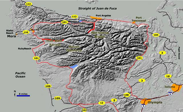
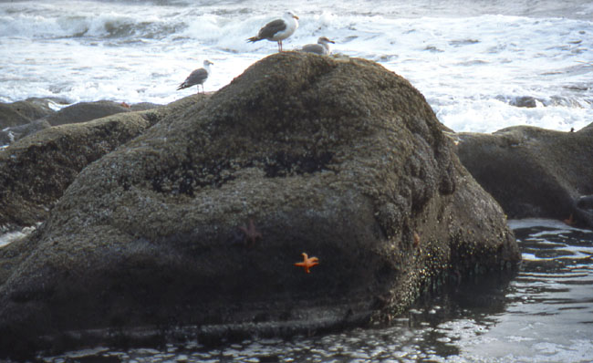
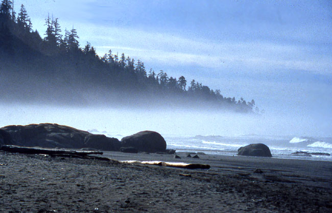
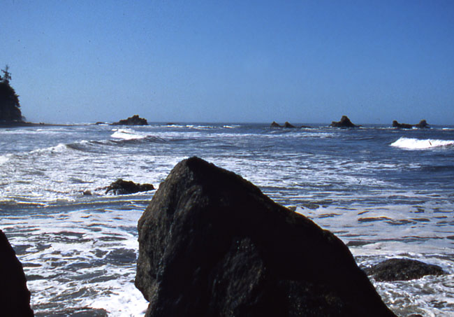
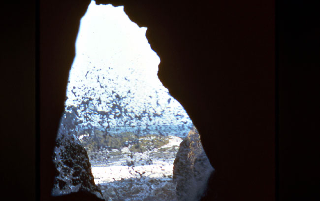
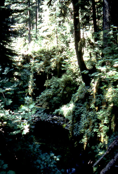
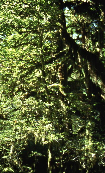
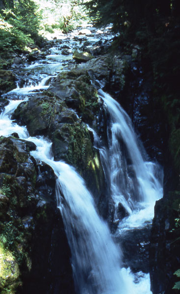
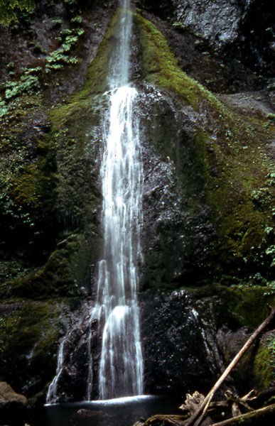
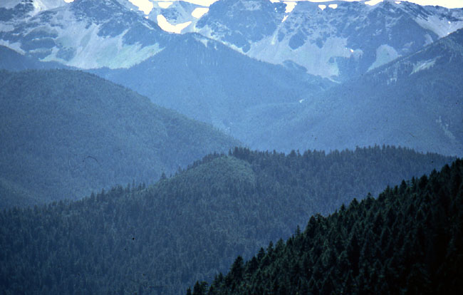
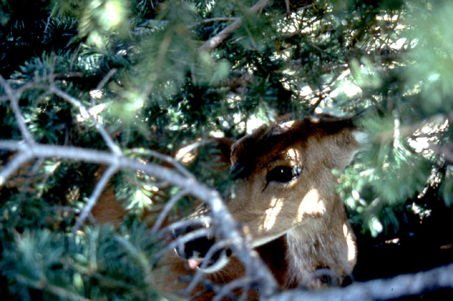
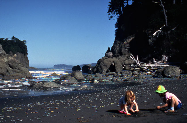
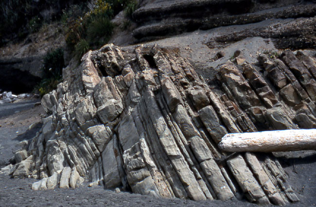
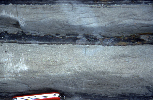
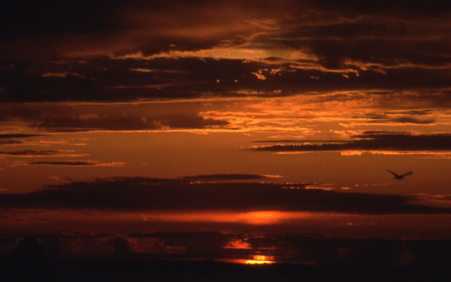
Image 1: Map of Olympic National Park. Welcome to your Olympic National Park tour! Jutting out into the Pacific Ocean, just west of Seattle in Washington, is this extraordinarily picturesque park, where the Pacific's moisture-laden winds dump rain and snow more rapidly than anywhere else in the lower-48 states. It’s also home to some of the country's greatest old-growth forests (with trees towering up to 300 ft), crystalline streams, cascading waterfalls, rugged coastlines replete with basking sea lions, tidal pools filled with urchins and starfish, and high peaks that sport active glaciers. Known more for its biology than its geology, Olympic is also the home for the largest subspecies of elk in the country, the Roosevelt Elk, which the park exists to preserve (thanks to, you guessed it, the Roosevelt’s). Photos by Richard & Cindy Alley, map by USGS.
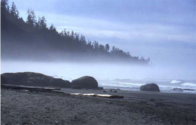
Image 2: Seagulls sitting on rock near Kalaloch at the SW edge of Olympic National Park. The Olympic Peninsula features beaches on three sides. Gulls and starfish grace the Pacific Coast near Kalaloch at the southwest edge of the national park, shown here.
Image 3: Fog along the coast of Olympic National Park. Cool waters offshore favor the formation of fog, which reduces evaporation from the trees. Combined with a general lack of hurricanes, tornadoes, and ice storms, this probably contributes to the ability of west-coast temperate-rain-forest trees to grow roughly twice as tall as their east-coast equivalents. Cutting of trees may increase wind flow and reduce fog, making it difficult for tall forests to re-establish themselves in some places, a problem raised with cutting of redwoods to the south.
Image 4: Coast of Olympic National Park with rocks jutting out of the water. The young, rocky coast is attacked by the waves of the Pacific, which exploit cracks and layers in the rocks to carve out interesting shapes.
Image 5: Sea Cave. A strong rock between cracks may be left standing in the waves as the rocks along the cracks are worn away. Continued attack by waves sometimes cuts through the remaining rock to make a sea cave, such as is seen here.
Image 6: Rainforest growth found inland at Olympic National Park.
Image 7: Epiphytes – plants growing on plants found inland. One hallmark of rainforests is the lush growth of epiphytes. This is a very difficult niche in which to live in climates with droughts, because lack of soil leads to lack of water-holding capacity; this difficulty is much smaller in a rainforest.
Image 8: Sol Duc Falls. The abundant rainfall feeds beautiful streams, some of which host important salmon runs. Sol Duc Falls is shown here.
Image 9: Marymere Falls, shown here, is almost ninety feet high. Don’t try to memorize these details--but take the pictures along if you’re going to visit so you know what to see. Instead, look for the big-picture geology, coming soon.
Image 10: The higher peaks in the park host glaciers. Peaks of similar elevation farther to the east do not have glaciers, however; the high snowfall, frequent cloudiness (blocking the sun) and cool summer temperatures cause glaciations to reach to low elevations at Olympic National Park. Melting of glaciers contributes to summertime stream flow, and the glaciers erode valleys more rapidly than rivers do.
Image 11: Mule deer in the forest. When your professor visited Olympic, he wasn't fortunate to see the famed Roosevelt Elk, but this mule deer was napping the day away, and looking remarkably inconspicuous.
Image 12: Two children playing on the dark sand beaches in Olympic. The beaches of Olympic typically have dark sand, eroded from the sea-floor rocks exposed along the coast. Many common dark minerals break down more rapidly than do light-colored minerals, so “old” beaches, such as those of the east coast where the sea has had a long time to interact with the sand, are dominated by light colors, but “new” beaches such as this are dark-colored. The young ladies enjoyed their visit!
Image 13: Layered rocks jutting out of the beach called Turbidites. The layered rocks in the center of the picture are a special type, called turbidites, shown and discussed in the next slide. The layers seen here were almost horizontal when they formed. But, the layers are now tipped up on edge, the result of deformation as the rocks were scraped off the conveyor-belt of the Pacific floor into the Olympic grocery check-out lane.
Image 14: Close up of the Turbidites, with a pocket knife at the bottom for scale. Sediment eroded from the Peninsula is moved by streams to the sea, and then taken farther out beneath the sea by waves. When an earthquake occurs (and sometimes for other reasons), a landslide or flow sometimes develops, carrying the sediment down into the offshore trench. Sand settles out of such a ”turbidity current” first, followed by smaller pieces (silt and clay). Just above the knife, the light-gray rock is sandstone, grading up into the darker siltstone and claystone. The next flow tore up the top of the clay, so there is mixing between the new, light-colored sand and the old, dark-colored silt and clay, followed by another sand layer and then another clay layer. These rocks were then scraped off the downgoing slab and brought to the beach for you to see.
Image 15: Pacific sunset in Olympic National Park
Virtual Field Trip #3: Mount St. Helens
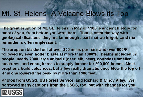
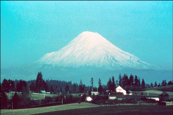
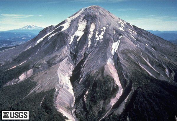
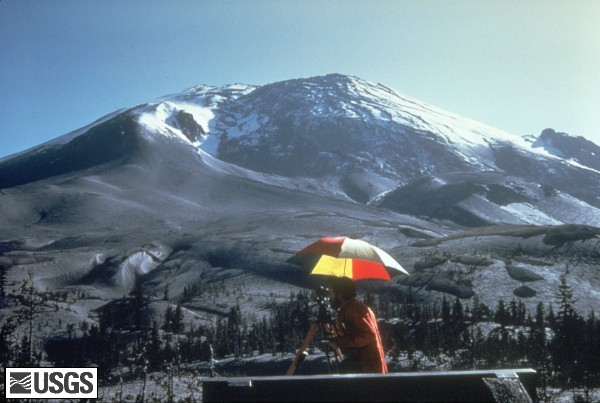
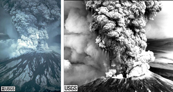

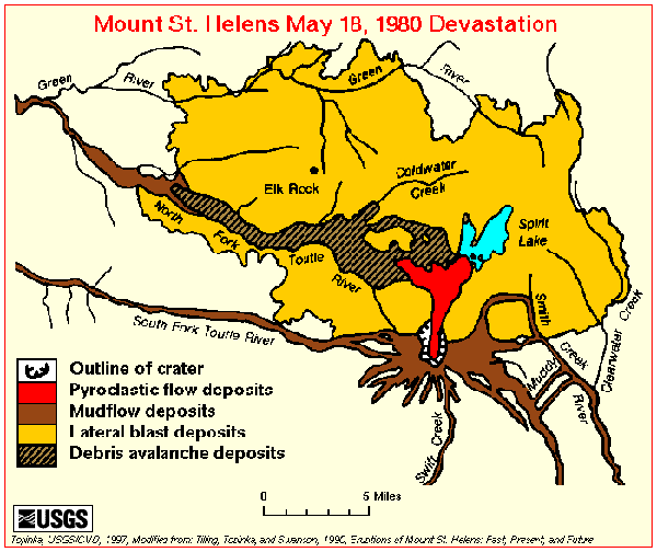
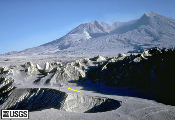
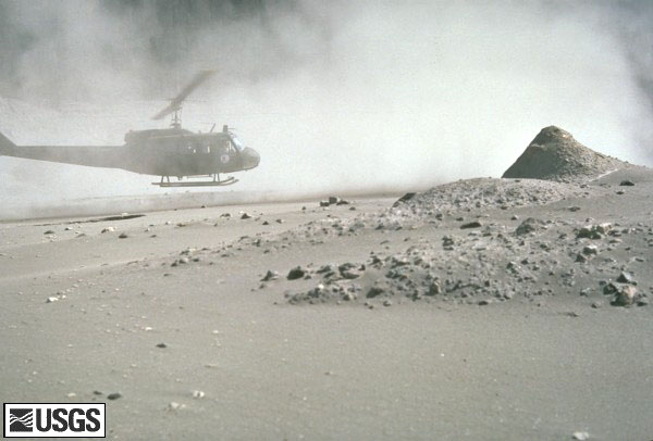
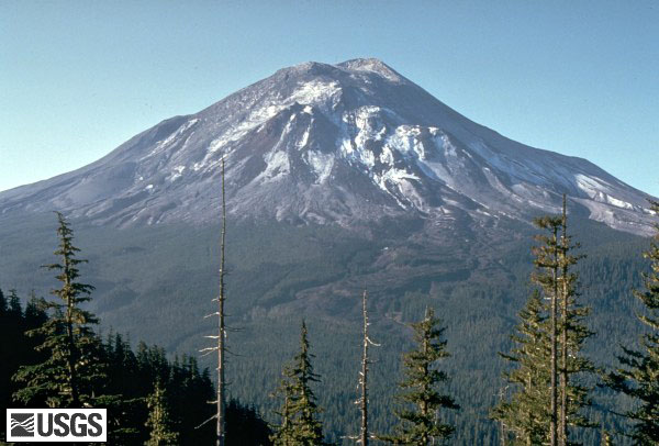
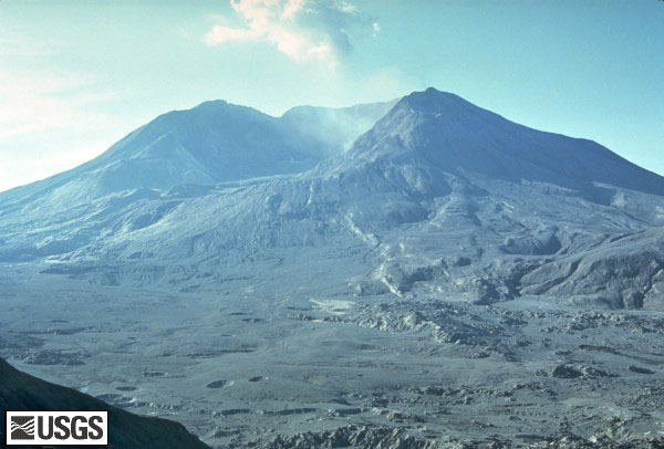
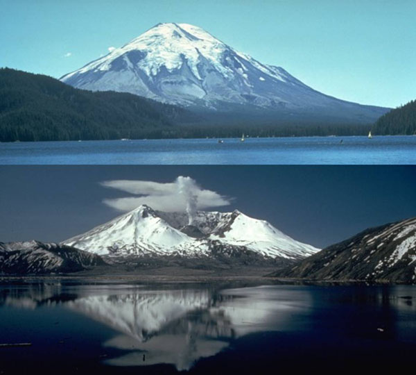
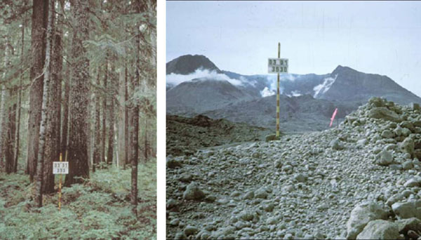
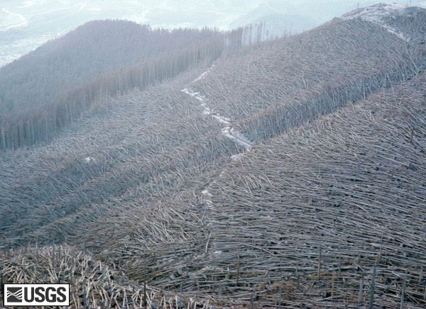
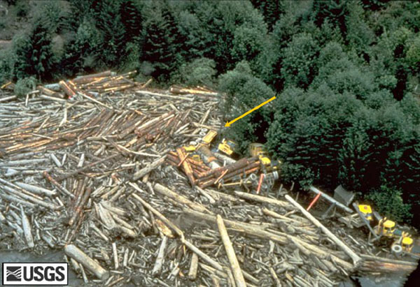
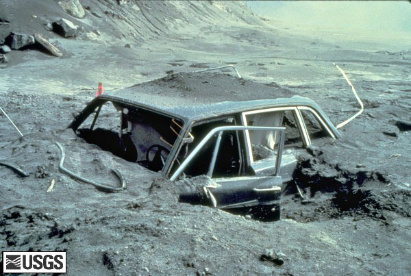
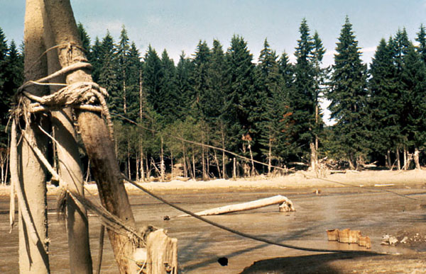
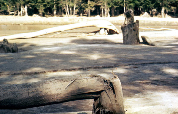
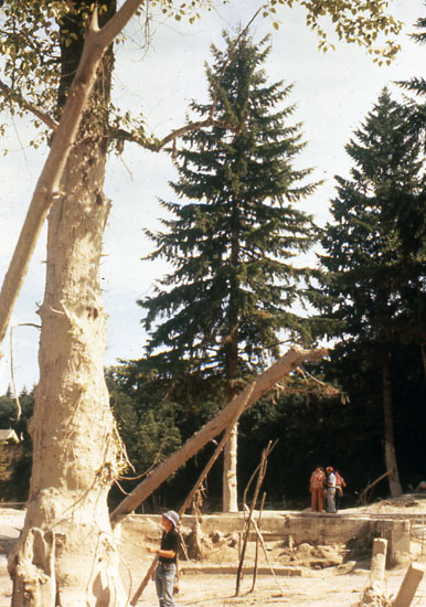
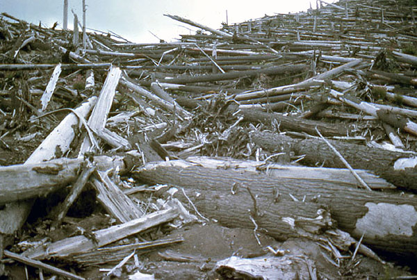
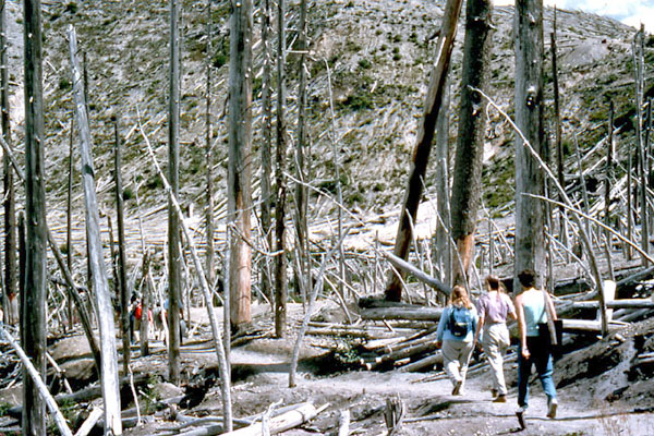
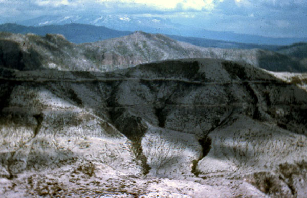
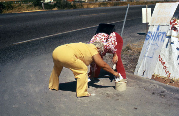
Image 1: Picture of ash in the sky from Mr. St. Helens. The great eruption of Mt. St. Helens in May of 1980 is ancient history for most of you, from before you were born. That is often the way with geological disasters – they are far enough apart that we forget… and the reminder is often unpleasant.
The eruption blasted out at over 300 miles per hour and over 600 degrees F, followed by even hotter blasts at more than 1300 degrees F. Deaths included 57 people, nearly 7000 large animals (deer, elk, bear), countless smaller creatures, and enough trees to supply lumber for 300,000 homes. Most eruptions build volcanoes, but a few really dramatic ones blow the top off—this one lowered the peak by more than 1300 feet.
Photos from USGS, US Forest Service, and Richard & Cindy Alley. We borrowed many captions from the USGS , too, but with changes for you.
Image 2: Mt. St. Helens, before 1980. Before 1980, Mt. St. Helens was the queen of the Cascades, snow-capped, symmetric, and beautiful. But, geologists knew that the peak had also been the most active of the Cascades over many centuries.
Image 3: Mt. St. Helens on April 10, 1980. In winter and spring of 1980, magma moved upwards beneath the volcano. (Magma is melted rock underground.) Small eruptions started, covering much of the snow with volcanic ash, as seen here. Mt. Adams, another Cascades peak, is visible behind and just to the left of Mt. St. Helens. This USGS picture was taken by Donald A. Swanson on April 10, 1980. No need to memorize numbers or dates here, but appreciate the power.
Image 4: Mt. St. Helens on April 27, 1980 shows a ‘bulge’ developing on the N. side. A “bulge” developed on the north side of Mount St. Helens as magma pushed up within the peak. Repeated measurement of the distance to the bulge (as shown here) found growth of up to five feet (1.5 meters) per day. By May 17, part of the volcano's north side had been pushed upwards and outwards over 450 feet (135 meters). You might not be surprised to learn that such a huge blister will tend to rupture and fall down. The view is from the northeast in this April 27, 1980 photo by Peter Lipman.
Image 5: Mt. St. Helens erupting on May 18, 1980. On May 18, 1980, at 8:32 a.m. Pacific Daylight Time, a magnitude 5.1 earthquake shook the peak, and the bulge and surrounding area slid away. The pressure release triggered a major eruption, as the magma bubbled and blew apart to create ash carried aloft by poison gas. The landslide from the bulge buried 24 square miles (62 square kilometers) of valley. Before going up as shown in these photos, the blast first went sideways, gravely damaging 250 square miles (650 square kilometers). Fifty-seven people were killed or are still missing. USGS photos by Austin Post (left) and Robert Krimmel (right).
Image 6: Plume of ash erupting from the mountain. For more than nine hours a vigorous plume of ash erupted, eventually reaching 12 to 15 miles (20-25 kilometers) above sea level. The plume was blown eastward at an average speed of 60 miles per hour (95 kilometers/hour), with ash reaching Idaho by noon. By early May 19, the devastating eruption was over. This May 18 USGS photo of the ash plume is by Donald A. Swanson.
Image 7: Map of the area affected by the May 18, 1980 eruption. Map of the area affected by the May 18, 1980 eruption. North is to the top, and the little scale bar at the bottom is five miles--this was a big deal. The blast knocked over trees across most of the yellow area. Much of the bulge ended up in the black-lined debris-avalanche deposits, while melted snow and ice plus water pushed out of lakes made the brown mudflow deposits. Thick layers of hot ash fell to make the red pyroclastic flow deposits.
Image 8: After the May 18, 1980 eruption, Mount St. Helens' elevation was over 1300 feet lower than before, and the volcano had a one-mile-wide, horseshoe-shaped crater. This photo by Tom Casadevall of the USGS was taken four months after the eruption, on September 16, 1980.
Image 9: Volcanic ash covering the landscape around the volcano. A helicopter is hovering near the ground. For weeks, volcanic ash covered the landscape around the volcano and for several hundred miles downwind to the east. Noticeable ash fell in eleven states. The total volume of ash (before its compaction by rainfall) was approximately 0.26 cubic mile (1.01 cubic kilometers), or, enough ash to cover a football field to a depth of 150 miles (240 kilometers). In this USGS photograph by Lyn Topinka from August 22, 1980, three months after the eruption, a helicopter stirs up ash while trying to land in the devastated area.
Image 10: Mount St. Helens on May 17, 1980, one day before the devastating eruption. The view is from Johnston's Ridge, six miles (10 kilometers) northwest of the volcano. USGS photo by Harry Glicken. The next photo is from nearly the same place, four months later.
Image 11: Mount St. Helens soon after the May 18, 1980 eruption, as viewed from a similar location as the previous photo, at Johnston's Ridge. USGS photo by Harry Glicken on Sept. 10, 1980
Image 12: Mt. St. Helens before the explosion - top of the mountain still intact. The mountain after the explosion showing the resulting crater. The blast lowered the peak by more than 1300 feet. These USGS (bottom) and US Forest Service (top) pictures are not exactly from the same place, but they’re close.
Image 13: Left image is a stand of trees. Second image is taken from the same place but shows no trees, piles of ash and the mountain with a crater after the eruption. Difficult as it may be to believe, these photos are from the same place, looking in the same direction! The trees on the left were obscuring a view of the beautiful snow-capped peak, which has been blown away, along with the trees, in the photo on the right. US Forest Service photos: http://www.fs.fed.us/gpnf/mshnvm/digital-gallery/25yearsofrecoverybefore... [6]
Image 14: Knocked over coniferous trees. They were knocked over by the eruption. These were towering coniferous trees before the eruption, but now are knocked over like matchsticks. Trees in the upper left weren’t knocked over, but were burned to death. USGS photo on Aug. 22, 1980 by Lyn Topinka.
Image 15: A destroyed logging camp including huge pile of logs and multiple full sized logging trucks. Destruction by a flood created by a landslide. The eruption melted glaciers, and the landslide pushed water out of Spirit Lake, together making a huge flood that destroyed many things including this logging camp on the South Fork Toutle River. Those yellow things in the upper-right are full-sized logging trucks destroyed by the flood (the arrow points at one). USGS photo taken on May 19, 1980, by Phil Carpenter.
Image 16: A car buried in lava approximately 10 miles from Mount St. Helens. Reid Blackburn's car, located approximately 10 miles from Mount St. Helens. Reid was a photographer for National Geographic as well as the Vancouver Columbian newspaper. Unfortunately, Reid did not make it out alive. A scholarship is now given by The National Press Photographers Association in Reid Blackburn’s honor. USGS Photograph taken on May 31, 1980, by Dan Dzurisin.
Image 17: Mudflow created by the melting of the glaciers. As noted for previous slides, the Mt. St. Helens eruption melted the glaciers on the peak, and also dumped immense amounts of rock material into Spirit Lake. The water displaced from the lake, and melted from the glaciers, mixed with volcanic ash and mud to make a giant mudflow that raced down the Toutle and Cowlitz Rivers, causing great destruction. This image and the next two, by Dr. Alley and his wife Cindy, show the situation miles downstream.
Image 18: Damage caused by the mudflow that raced down the Toutle and Cowlitz Rivers include a tree broken off a few feet from the ground. Another view of the damage caused by the immense mudflow that raced down the Toutle and Cowlitz Rivers. The broken trees attest to the power of the mud-filled flood.
Image 19: Another view of the mudflow. In this one, a much younger Dr. Alley (this was 1980, remember) is visible in the lower-left of the picture, dwarfed by the high-mud mark on the tree. The tourists on the right are looking at the foundation of what had been a house.
Image 20: Many logs scattered across the landscape 10 years after the eruption. Some bark remains on the trees. In this picture taken about 10 years after the eruption, trees knocked over by the blast are scattered across the landscape. Some bark remains on these; they were slightly shielded by a hill and were not as strongly blasted as some.
Image 21: 10 years after the eruption students walking through a stand of dead trees that were largely shielded from the blast. In this image taken about 10 years after the eruption, members of a geological field trip attended by Dr. Alley take a walk through some standing former trees that were greatly shielded from the blast, which came over the hill from diagonally behind the camera position. Notice the green vegetation flourishing on the far hillside; salmonberry, fireweed and others moved back in quickly.
Image 22: Part of the mountain with no dead trees. Many trees were salvage-logged. This third picture of Mt. St. Helens a decade after the blast shows deep gullying in a region without dead trees. Many dead trees were salvage-logged because of the value of the lumber, but such actions do have consequences for the landscape--without dead trees to dam the flow, rains feed little streams that rapidly wash away the loose soil, making it harder for new plants to grow.
Image 23: Two women collecting vials of ash. Mt. St. Helens was a media star. T-shirts, coffee mugs, and vials of ash were among souvenirs sold to enthusiastic tourists. These ladies realized that people standing ankle-deep in Mt. St. Helens ash were spending $5 for a little vial of Mt. St. Helens ash, and so the ladies decided to gather some of their own. The colorful garb is possibly reflective of the era.
Image 24: Some additional links about the Mt. St. Helens story.
Virtual Field Trip #4: Hawaii Volcanoes National Park
.jpg)
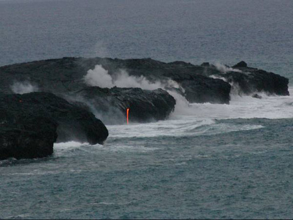
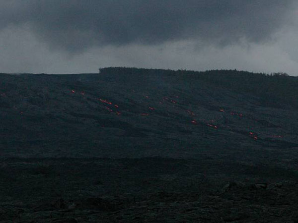
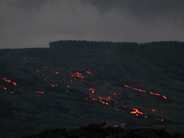
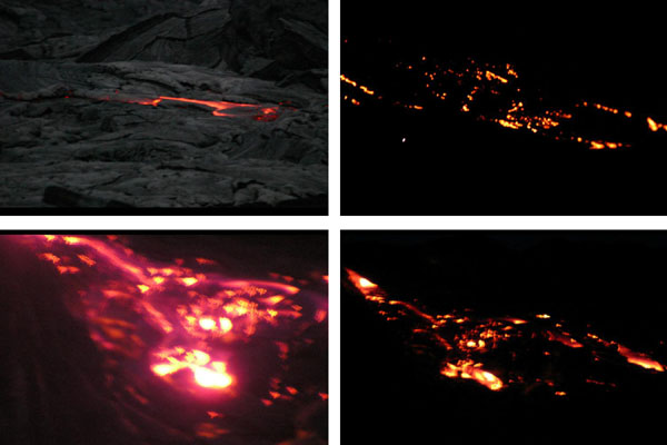
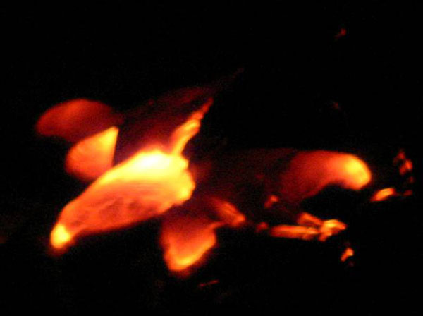
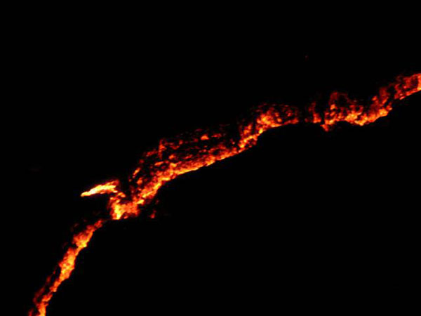
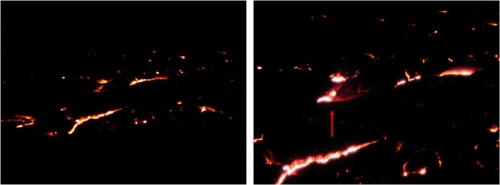
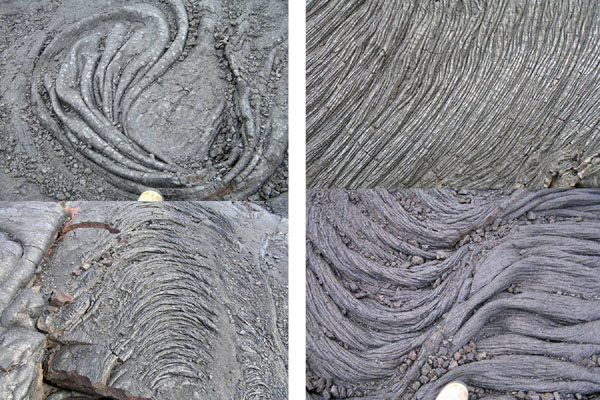
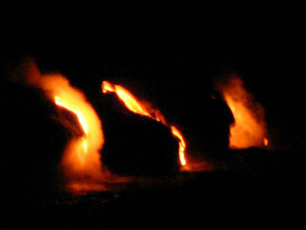
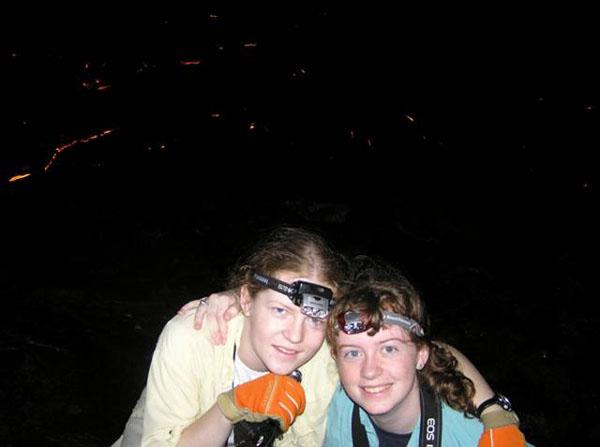
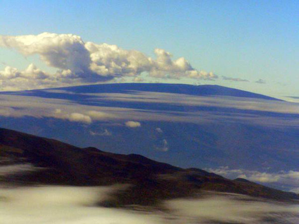
Image 1: Mauna Loa mountain. Mauna Loa (13,679 feet above sea level); Hawaii’s peaks start from 18,000 to 19,000 feet below sea level, making them the tallest mountains on Earth. Mauna Kea (peak at 13,796 feet above sea level, is out of picture to left)
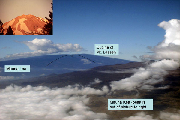
Image 2: Mauna Loa on the left of the picture, Mt. Lassen in the middle and Mauna Kea is off the picture to the right. The hot-spot volcanoes of Hawaii are vigorous enough to kill the unwary, but are much more approachable during eruption than are the steep, explosive stratovolcanoes of the Ring of Fire and elsewhere, such as Mt. Lassen. This slide show gives you an up-close-and-personal visit to this “nicer” Hawaiian lava.
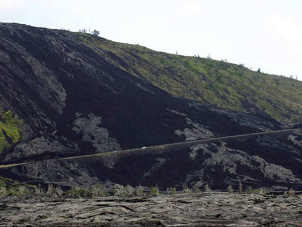
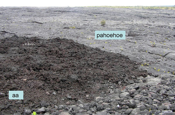
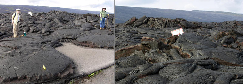
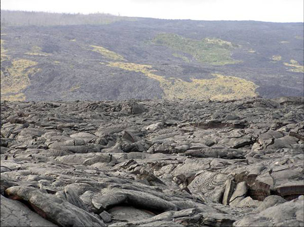
Image 3: Chain of Craters Road, Hawaii Volcanoes National Park. Older flows, now vegetated, are green. Darker flows are either gray pahoehoe (pronounced pa ho ee ho ee; ropy lava from hotter flows) or black aa (pronounced ah ah; broken-up lava from cooler-but-still-really-hot flows).
Image 4: Close up of lava Pahoehoe (sloid) and aa (looks crumbly)
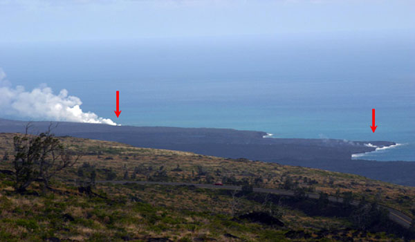
Image 5: View of ocean with steam rising out of the water. The steam shows where lava is entering ocean.
Image 6: Janet and Karen Alley, on what used to be the continuation of Chain of Craters Road, now lost beneath lava flows from the East Rift of Kilauea volcano. The hike to the active lava from here is just enough adventure to be exciting.
Image 7: Chain of Craters Road was lost, along with almost 200 houses and other buildings, when engulfed by lava.
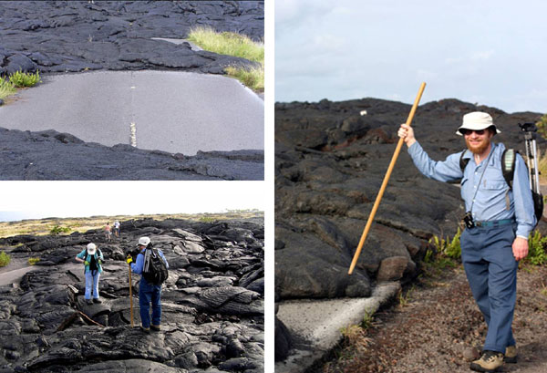
Image 8: Two pictures. Left, Karen and Cindy Alley along the former Chain of Craters Road. Right, a ‘no parking’ sign buried in the lava. The ropy pahoehoe lava is a strange surface for hiking, but can be traversed safely by careful hikers.
Image 9: The “trail” to the active lava showing Pahoehoe. Hot lava is still flowing down the hill in the far upper right of this picture, as you will see in later photos.
Image 10: Lava flows out of tubes in the rock into the sea. You can see the red lava flowing into the sea and the steam rising out of the ocean where the lava enters. We didn’t get down to measure, but the higher “lava fall” probably is more than 30 feet tall.
Image 11: Closer view of lava flowing into the sea from a large rock outcropping.
Image 12: Mile-wide view of lava flowing from the East Rift of Kilauea. On a sunny day, the hillside looks black, but as darkness falls, the glow of the molten lava shows.
Image 13: Slightly closer view of glowing lava
Image 14: Glowing lava.
Image 15: Glowing lava.
Image 16: Glowing lava.
Image 17: At roughly 2000 degrees F, the lava glows in the night. The lava surface chills rapidly in the air, forming a glassy shell, which then crackles and breaks as the sizzling lava moves beneath. You can sometimes watch a new crack appear as you hear the breaking glass. The red arrow points to a tongue of lava that will harden to look like the pahoehoe tongues shown in the next slide.
Image 18: Hardened lava tongues (pahoehoe). Four pictures showing different flow patterns.
Image 19: “Lava Falls”
Image 20: Karen and Janet Alley with hot lava flowing in the background.
Want to see more?
Here are some optional vTrips you might also want to explore! (No, these won't be on the quiz!)
Hawaii Volcanoes National Park and a second Crater Lake Slideshow [7]
(Provided by Dr. Alley)
Hawaii [8]
(Provided by USGS)
Crater Lake National Park [9]
(Provided by UCGS)
Crater Lake National Park - 3D version [10]
(Provided by UCGS - red/cyan stereo viewing glasses required)
Mount St. Helens National Volcanic Monument [11]
(Provided by UCGS)
Olympic National Park [12]
(Provided by UCGS)
Word Document of Unit 3 V-trips [13]
GeoClips
There are three Unit 3 GeoClips (movies) linked below. We hope they help you understand Unit 3 just a little bit better, and that you enjoy them.
Hawaii: Night Lava
Hawaii Volcanoes National Park below the east rift Kilauea, this is the lava headed for the sea. It is 2,000 degrees Fahrenheit or so. This is the innards of the Earth turning inside out, building new land that we're sitting on right now. And this is way cool because it's so hot. You just can't imagine what this is like.
Below us, it is fountaining into the sea and jetting up great bursts of steam. New land being born, this is geology in action, this is the real thing. The breeze blowing over us is a little bit sulfurous, it's a little bit warm-- we're going to get out of here fairly quickly. But we're having a lot of fun, I wish you could be here with us. This is an amazing, amazing sight.
Hawaii: Lava Tube
We're in the rain forest on the side of Kilauea, and behind me is a lava tube. A great lava flow came through here in the past, the top freezes first, the sides freeze, the inside-- glowing hot lava-- comes flowing out, and it drains. And you go inside and there'll be stalactites that were little drips that were falling off the ceiling when they froze. And this is the way a lot of the lava gets to the coast. It's that the top will freeze, and the insides will go squirting on out to the sea. And so it's a really interesting place, a very different kind of cave.
The hot spot of Hawaii erupts runny lava to the surface, giving some very interesting features, such as the lava tubes you will see forming in the first video, and formed in the second video. The hike out to the flowing lava was, in spring of 2007, over three miles across rough, often broken and glassy lava that solidified from glowing hot flows over the last couple of decades. Whales were spouting offshore when Dr. Alley and family made the trip. Tag along, and see what they saw.
Hawaii: Southwest Rift
The Southwest Rift of Kilauea on Hawaii. There's a vast and fascinating volcanic history sitting here. Layers of rock that were made of pieces that were tossed through the air. Glass that froze in the air as it was thrown as molten little bits from the volcano, and then other sorts of layers.
Then there's been a great cracking here, probably an inflation from underneath as melted rock is moving underneath that sort of bubbles things up and breaks it. Then an eruption happened at some point, and there was actually sort of a waterfall of melted rock, and it was flowing into the crack. And we can see behind me all these places where this stuff has flown down into the crack. Just a wonderful record of the excitement of the geology of this place.
Lava was erupting in the Southwest Rift of Kilauea not that long ago. Sometimes, the lava erupts with a little force, throwing pieces that freeze to glass in the air and rain down. Other times, the lava flows even more quietly along the surface. Here, you can see evidence of both.
Want to see more?
Optional Videos, for your enjoyment (and education, but you won't be quizzed on them.) Volcanoes are just too interesting to leave so quickly, so here are some more looks at these important, and dangerous, pieces of our planet. First, visit Hawaii again, and see some strange things. Then, head over to Sunset Crater Volcano National Monument, Arizona, with the CAUSE class. Have fun, and keep your feet cool!
Hawaii: Tree Mold
I am in one of the stranger positions in one of the stranger places you'll ever see. The camera is looking right down on me, and I am sort of lying over the ground. And behind my head is a tree mold in Hawaii Volcanoes National Park. There used to be a giant Ohia tree here. A lava flow came in around it, the lava chilled where it hit that tree and was boiling the water away from the bark. Eventually the tree rotted out, but it left its shell of lava sitting here behind me, and you can see sort of the shape of the bark sitting here in the tree.
Then a new tree has grown, and is putting its roots down in the hole where the old one was. But this is the mold that was left from a tree that was hit by a lava flow. And it's really something you can see. There's places in the park where there are footprints that you can see, where people walked in the lava, and here's the mark of a tree.
Hawaiian lava flows engulf whatever is in their way, including trees. What happens when hot lava hits a cold, wet tree? Find out here, your chance to look down on Dr. Alley.
Hawaii: Boiling Cauldrons
Kilauea, Hawaii Volcanoes National Park. Deep beneath us, a boiling cauldron of melted rock that wells up from possibly the core mantel boundary on the giant hot spot that is Hawaii. Next to us, the great crater here, fills with magma, with lava, that comes boiling up from below. And then it rifts out, it breaks, and you get cracks in the ground, and the lava flows out, and it is now flowing into the sea and building new pieces of the island just below us down at the coast.
Around me here, you can see swirling-- the fogs, the mists, the steam, the hot sulfurous gases that come off of this volcano. Where the rain from above soaks down through the cracks, it hits a hot rock, it flashes to steam, and it comes boiling out. This is a place where geology lives, where geology is living right now. And it's an amazing place to try to breathe in this.
Kilauea Volcano is a wonderful place to visit. Stay in the lodge on the rim, and you'll wake up to the view shown here behind Dr. Alley.
Cinder cones are rather odd volcanoes, formed of pyroclastic bits tossed through the air to pile up near the vent. If you let the spaghetti sauce boil on the stove, without a lid, you would soon have a lot of tomato-sauce blobs around the pot. Let those build up, and you are heading for a cinder cone. Here, see three different versions of the cinder cones at Sunset Crater.
CAUSE 2004 - Sunset National Park #1
Right now we're at-- this is called Lenox Crater, and it's a volcano. It's a cinder cone volcano. If you looked around behind us, right at the center there's a big crater, hence the name. And all the stuff that we're sitting on right here is cinders, basalt rock that was ejected from the volcano. And as it was ejected, it was thrown up and out, kind of like this. And--
Kind of like what?
[LAUGHTER]
Kind of like that. And it just over the years built up and built this-- what did it say, it's 400 feet high or something like that? Yeah. Not too bad.
An explanation of cinder cone volcano formation by CAUSE student Sam A.
CAUSE 2004 - Sunset National Park #2
ROh. That was hard. Why?
Well, Ryan you just walked up a really steep side of a volcano.
What volcano?
This volcano.
That's a volcano?
Yeah. Right over there's the center of the volcano. And we're sitting on top of cinders that were thrown out of the volcano.
What's a cinder?
These are cinders.
What are they?
OK, imagine this is the bottom of the volcano. Stuff's thrown out of the center of the volcano. And it starts to build up around the side. So eventually when enough stuff's thrown out, you get a steep-sided volcano. It's just layer, upon layer, upon layer, upon layer, upon layer of stuff that's ejected out of the volcano, falling down on top of each other.
How far does cinder travel?
Well, we're sitting about a quarter mile from the center of the volcano, so these cinders traveled about a quarter mile. They can go further than that, a mile.
So if this is cinder, it's so small. I mean, are they all this small?
Yeah. Well, some are real small, some are a little small. Some are big, and some are the size of Volkswagens.
Oh. But Stef, I still don't get it. I mean, where else are we going to see this in the real world?
Have you ever made spaghetti?
Yeah.
All right. Well, think of a pot of spaghetti sauce. You've got the heat cranked up real high, and the sauce starts boiling. You get bubbles and then, next thing you know, you've got butter and spaghetti sauce. You've got spatters of sauce all over your kitchen stove.
And that's exactly what's going on over here?
Yeah. Why don't we go to take a look?
OK.
Go down in the crater.
Hey!
Another, slightly "dramatized" explanation of cinder cone volcano formation by CAUSE students Stephanie S. and Raya G.
CAUSE 2004 - Sunset National Park #3
We're looking at Sunset Crater, a volcano that erupted almost 1,000 years ago. It's primarily a cinder cone, so when it was erupting it was sort of spitting out little pieces like a pot of spaghetti sauce bubbling and throwing things.
Those little pieces-- we can actually see similar pieces from either that one or a different eruption here. And we've been walking on them, and they're not terribly pleasant for walking on, but you can build a pile out of stuff like this. There's probably lava flows helping to hold that one up.
A little more oxidized late in the eruption, and so you get that pretty red around the top that gives the Sunset Crater name.
A third explanation of cinder cone volcano formation, by Dr. Alley himself.
Video Lecture
There are TWO Unit 3 lectures both featuring Dr. Sridhar Anandakrishnan.
Start with the first lecture. It is 40:50 minutes long.Welcome to G-Sci 10, Geology of the National Parks. My name is Sridhar Anandakrishnan, and I'll be your guide through some of the beautiful parts of the planet. Last time, we talked a little bit about Death Valley, about the spreading, about how Death Valley is going apart. This time, we're going to go slightly further north up along that same coast, go up to Crater Lake National Park, an absolutely gorgeous place, head on up the coast a little bit further, up to Mount St. Helens, go over and take a look at the Olympic National Park, and really understand why these volcanoes, Crater Lake, Mount St. Helens, why those two volcanoes are where they are.
And we're going to actually spread our picture out a little bit beyond that and look at why there are volcanoes in other parts of the world. All right? So, we'll start our talk about making mountains and making volcanoes, why they are where they are, and what they can tell us about the insides of the Earth.
Here is a screenshot that I took on my computer of a program called Google Earth. And I encourage all of you to go out there and download it. It's free. It runs on Macs. It runs on PCs. And it's a wonderful program for just looking at this planet. You can wander around to different parts. You can zoom in, zoom out. And I really encourage you to download it and to use it. It will really give you a good sense of how big this planet is that we live on.
I've circled in those sort of blue squiggly lines. They're not the best pictures in the world. But you can see that there are some places on the West Coast of the US. That's California on the bottom, Oregon in the middle, Washington state on top. And the circles represent the areas that we're going to go to, Crater Lake National Park on the bottom, Mount St. Helens in the middle. And then right up on the top, right up jammed up against the Pacific Coast is the Olympic National Park. So, as I said, go get yourself Google Earth, and you'll be able to zoom in to these spots yourself.
The other thing that you can do is you can go to your website, go onto Angel, and you'll be able to download what we call V-Trips. They're virtual field trips to these places and to other places. And they're just PowerPoint presentations or web page presentations that just have beautiful pictures of these places.
Let me take you to a couple of these places right now. We'll go take a look at Crater Lake. We'll take a look at Mount St. Helens. And then we'll come back and start the lecture proper.
I like to do this to motivate you, to say, man, these are beautiful places. I want to go see those, and I want to understand them. I want to know why there is a volcano there. So, let's hop out of this program real quick and go over and take a look at Crater Lake National Park. As I said, this is on Angel. You can see all this for yourself. I'm going to whip through it quickly. But you can find it on there.
So, this is just a shot looking down from the rim of Crater Lake through all these lovely trees, down onto that blue, blue, blue water. Crater Lake is this volcano way up high on the top of this mountain, up at 6,000 feet. And that water is as clear and as beautiful as anything.
It's just all snow melt that comes down into the crater. There are very few streams that bring in sediments into it, and no industry, no pollution, no agriculture. And so, that water is as blue and as beautiful as they get on this planet.
Here's a picture on the sides. Even though this was late in the summer, you get lots and lots of snowfall. As you can see, our friend there is wearing his T-shirt as he slides down the side of Crater Lake in the snow. Even though it's in the middle of summer, there's still lots of snow.
So, you pull back. Here's a picture of that crater. The bottom of it there is water.
You can see the far side of the crater. We're standing on the near rim. It's an almost circular feature with this little island called Wizard Island rising up in the middle of it. And then there's the far rim that you can see. And if I could pan, if this camera could pan around, you would see that rim continuing around all the way until it came back to where you are.
Absolutely gorgeous place way up high in the mountains, as I said, 6,000 feet. It's a spectacular place to go and see the world. Here's just another picture looking out over that blue, blue, beautiful water.
Here is a very garishly colored picture of the depth of the water. The purples are where the water is very, very deep. And the grey-white parts are the rim.
So, you can see that near-circular crater with Wizard Lake off on the left side there, that little dome that's starting to build. And then over in the top, there's another little dome starting to build. So, this has something to do with volcanoes. So, let's find out more.
And this is just a picture from Crater Lake looking along the Cascade ranges. And you can see in the distance one, two, three, four volcanoes, each of those perfect little cones marching up the coastline. Why? Why are there volcanoes there? Why aren't there any volcanoes here in central Pennsylvania? Why do they have four of them over there in Oregon in Washington?
That seems awfully unfair. They get all the volcanoes, and we don't get any. Let's find out why they've got them.
Here is a map of the California, Oregon, Washington coast. Each of those little triangles is a volcano. Lassen, Shasta, Medicine Lake, Crater Lake, that's the one that we're going to be talking about. And on the right, you have a little graphic depicting when they most recently have erupted.
As you probably might know, Mount St. Helens erupted in 1980. And that's marked on the right over there. Mount St. Helens has been very, very active, erupting many, many times over the course of the last 4,000 years.
And it's actually getting even more active even as we speak. The dome is starting to build today. And it might be due for an eruption in the next few years to tens of years.
Here's just a beautiful peek of Lassen Peak. It's not Crater Lake, but it's another volcanic peak. Whenever you see one of these nice triangular mountains, you should say to yourself, volcano. It's just a beautiful spot. And here's another view of Lassen Peak, looking at it from a slightly different place.
All right, here is a picture of a little car, a little 1980 Chevette going up the road to Lassen Peak. You can see all the snow there, even though it was the middle of August. I encourage you to go on to the website and just take this V-Trip. And it will encourage you to go there.
This, we went a little bit further afield. Those little white dots are sheep. When you think sheep, you should think New Zealand. And this is indeed a shot of Mount Ruapehu in New Zealand, another volcano on the other side of the Pacific Ocean.
All right, enough wandering around the world. Let's learn why those volcanoes are where they are. So, plate tectonics two, making mountains and volcanoes.
Here is a map of the world. And what we're looking at here is North America, and the US in the middle. The Pacific Ocean is on the left. And each of those little red dots is a source of volcanic activity.
And you should be able to see that those dots circle the Pacific Ocean. Sure, there's a few volcanoes in the Atlantic Ocean. Iceland in particular has quite a few. There's a few volcanoes that occur in Africa and Arabia. But most of them are around the circum Pacific, Australia, New Zealand, heading up the coast towards Japan, over to Alaska, and then down the US and Canadian coast, and then down through Central and South America.
Why? Why is it that these volcanoes are where they are? So, here's a graphic showing where all of these volcanoes are. And because all these volcanoes stretch right around the Pacific, we call it the Ring of Fire. It's a nice, evocative name.
There's another thing that happens that goes along with these volcanoes. There was a curious thing that people noticed is that if you were to take the water out of the Pacific, in the same place where you have all these volcanoes, you'd see these really deep ocean trenches. The ocean would go down 10,000, 20,000, 30,000, in some places even more, 40,000 feet. It's an extraordinary thing. It goes way, way down, as deep down into the ocean as mountains are high.
Why? Why are there trenches that go along with volcanoes, but no trenches anywhere else? That's the second thing people notice.
The third was that you get these big earthquakes in the same place. Volcanoes, deep trenches, big earthquakes, how are they all related? How do they all come together? And then the next thing is we're going to take a look at one of the great songs of all time.
[MUSIC PLAYING - "RING OF FIRE" BY JOHNNY CASH]
By the great Johnny Cash.
[MUSIC PLAYING - "RING OF FIRE" BY JOHNNY CASH]
So, I hope you enjoyed that. And you should be grateful that I did not try to sing that for you.
So, the overview that we're going to-- what we're going to try and go over in this class is ocean materials made of spreading ridges. We saw that last time, Death Valley, mid-ocean ridges. So, somehow ocean materials made at these mid-ocean spreading ridges, material comes up, freezes on, spreads off to the side, if you remember that from last time.
It collides with continental crust. So, all this material is being made in the oceans. It runs into the continent, and something's got to happen.
And what happens is one of two things. Either you get subduction, where that continental crust goes over, the oceanic crust goes under the continental crust. This material gets subducted.
Or you get accretion, where the continental crust and the oceanic crust run into each other, and they actually glom together to create new land. All right? So, those are the two things that can happen. Some of the side benefits, if you will, of that collision of either the subduction or the accretion is the creation of volcanoes and mountains and these deep oceanic trenches.
The third thing that we'll talk about this time is hot spots. And I'll get to that in a minute. Let's talk about subduction and accretion first.
To review, this you should remember from last time, the mantle is a deep part of the Earth, way down deep. You have those hot, relatively soft rocks that make up the asthenosphere. The upper part of the mantle and this crust are this rigid, more brittle mass of rocks called a lithosphere.
And the lithosphere, this upper part, is broken into a number of smaller plates. And these plates float over on top of the asthenosphere, and they will occasionally run into each other. Where they run into each other, that's where these mountains are made.
The convection cells, they bring up this mantle material. It freezes at these mid-ocean ridges. And then the ridges push material off to the side. So, the ocean is continually moving its crustal material off to the side.
That stuff has got to go somewhere. We don't live on an infinite plane. We live on this nice, round planet. So, if you push stuff off to the side, eventually it's got to hit something.
And this is my depiction of what the Earth looks like. If I took the Earth and took a great big hatchet and sliced through it, what I would find is I have the outer core, and then I have-- or the outer lithosphere. And then right in the middle of it, we would have the inner core, which was solid, the outer core that was liquid. And then right up at the surface, this is where we live. There's trees and houses and so on and so forth.
Right underneath that, we have the crust, which is part of the lithosphere. Underneath that, we have the mantle, which is this hot, soft rocks. And then right in the middle, you have the core, which is either solid right in the middle or liquid outside of it. So, this is a little bit a review of if I could take this hatchet and slice through the Earth and look at it from this side, this is what we think we would see.
We don't really know. Nobody's ever drilled into the Earth much deeper than a few miles, three or four miles. So, all of this is inferred from other evidence. But we think this is a pretty good picture of it. It's probably grossly simplified, but this is what we think the world looks like.
I'm going to redraw that picture here. Here we have the Earth again, sliced through. The upper part of it is called the lithosphere. Underneath that, you have the asthenosphere.
And that lithosphere is broken up into a number of little plates. I've just labeled them plate one, plate two, plate three, and so on. So, we've taken a cross-section through it. In your head, you have to imagine that this thing is a globe or a sphere, and those plates are all riding on top of the surface of that globe or sphere.
From the interior of the Earth, because of the heat inside of the Earth and the heating of the rocks that makes them low-density, that material rises up through the asthenosphere until it gets to the surface of the Earth, where it cools off and then sinks back down in these convection cells. All right? So, this should all be review if you remember it from last time.
But what goes on as a consequence of these mantle convection cells is that these plates, plate three there, for example, will slide off in one direction. And plate two will slide off in the other direction. And when plate two slides off, what happens to it? It runs into plate one. All right? You can see that plate one is in its way.
Plate two runs into plate one. Something's gotta happen there. And at that collision spot, that's where either subduction or accretion takes place.
So let's talk a little bit about this oceanic crust. We have these mantle convection cells, materials coming up from deep inside the Earth. It's deposited underneath the oceans. And it cools off, gets more dense, gets shoved off to the side. And this mantle material is basically basaltic.
Basalt is a mineral. It's heavy in silica, iron and magnesium. It's dark in color. It's relatively dense compared to continental crustal material.
Density is a key notion that I've talked about a little bit last time. I'm going to talk about it this time. You'll keep running into it over and over again during this class.
When something is dense, for its size, it's relatively heavy. So, if I have a bottle of water here, I can fill it up with water. And it will have a certain weight to it. And if I divide the weight by the volume of this bottle, I have its density.
I could pour this water out, fill it with olive oil, extra virgin olive oil, please, always. And it would weigh different. It wouldn't weigh the same as the water in here because oil has a different density than water does. You know this stuff, but it's worth emphasizing it anyway.
Ocean floor is mostly basaltic, formed at the ridges. Because we know the Earth isn't getting bigger, as this material comes up, it isn't as if there's this material that's coming from somewhere else. It's all being recycled. It comes up, and then it goes back down. The Earth stays the same size.
What is subduction? That's a word that you ought to write down, maybe look it up in a dictionary. To subduct means to go under. "Sub," under, "duct," I'm not quite sure where that "duct" comes from. I'm not an etymologist. But subduction means for oceanic crust, as it gets denser, as it cools down, moves away from the ridge, gets denser, it starts to sink back down into the mantle.
Think of a lava lamp. If you go onto the Angel website, there's a little movie there, it's a little bit goofy, but it's fun, in which I have a lava lamp. And I show you how that material in the lava lamp rises up as it heats up, and then it goes to the top, and then it sinks back down again. The reason it's sinking down again it's getting cool, meaning it's getting dense.
All right? So, that's what's going on there. And this is to remind you, this is the goofy movie that you will find on the website of the lava lamp.
As this cooling oceanic crust moves to the side, it'll run into a continent. It might run into a continent. It sometimes does, sometimes doesn't. But in the case of the western US, it does run into the continent. It runs into California, Oregon, and Washington.
So, this cooling Pacific oceanic crust is heading eastwards. And there, bang, in its way is California, Oregon, and Washington. They're sitting there in the way, and this oceanic crust runs into it.
If it is cold enough, if it is dense enough, if it is so dense that it wants to sink down, then it does sink down and goes underneath the oceanic crust, which is low density. And it bobs up high. The continental crust is low-density and bobs up high, and so, the oceanic crust, which is higher density, will go underneath it.
If it is still relatively warm, if it hasn't had time to cool down, only recently it was formed, and it runs into the continent, it's still buoyant. It still rides high up there, doesn't want to sink down. Then when the oceanic crust and the continental crust meet, then the oceanic crust doesn't sink down. It just stays up high, and you get what's called accretion. And we'll talk about that.
As this ocean crust sinks down, and I'll draw a picture of it for you in a second. But let me get the words out, and then we'll go back and look at this picture. As this ocean crust sinks down, it carries seawater and sediment with it as it goes underneath the continental crust.
As it sinks down, it starts to heat up again. Remember, the Earth is hot inside. What's the reason for it? You know it. We talked about it last time.
The reason it's hot is because of radioactive decay inside the planet. Inside the Earth, there's all of these radioactive atoms that are slowly splitting apart, giving up a little bit of heat. And so, the inside of this planet is warm.
So, as this oceanic crust sinks down, carrying its water, carrying all these sediments as it sinks down, and starts to heat up, this added water, these added sediments help that crust to melt. If all we had was that oceanic crust, you could heat it up. And you'd have to heat it way, way up before it would melt.
But because of all these impurities that have been added, the water and the sediment, that stuff melts really quickly. All right? Most things melt better in the presence of impurities. And this is an example of one of those.
So, let's take a look at a picture of that whole thing. Here's my cross-section through the ocean. I've drawn a mid-ocean ridge.
We have material coming up from underneath. It's being deposited at this mid-ocean ridge. That's that little peak over there.
And as it cools, it gets shoved off to the right. So we have material coming up, and material gets deposited, cools, and gets shoved off to the right. There's more material going off to the left, but lets only worry about the stuff that's going off to the right.
Here's my picture of the ocean. And there's a little boat. And there's a little fishy. So now you know that's the ocean. It's got a fishy in it. And the sea floor there is the black line.
And that material is physically moving off to the right. If I could go there and put a mark in it, I would come back a year later, and that mark would have moved a little tiny bit to the right, maybe half an inch, maybe a tenth of an inch. But it would have moved a little bit.
Now over here on the right, in the green, I've drawn the continent. So this is the coast of California. This is the coast of Oregon.
What's going to happen when that black line runs into that green line? The continent is low-density. The ocean is basalt. It's high-density.
When the two run into each other in this case, because the mid-ocean ridge is way far away, the basalt has had a lot of time to cool down. It's high-density. It wants to sink back down, and it will. It will subduct down underneath the continental crust.
And in the process of subducting-- I'm sorry, I had to draw a new picture here because my last one got so ugly. In the process of subducting, it will carry down material with it. That junction there that I've circled in yellow has water, and it has ocean sediments with it.
So two things happen at that junction. The first is that the continental crust and the oceanic crust get deformed to form these trenches. So without this motion of the oceanic crust going underneath the continental crust, we wouldn't have that little dip that you see, where the black and the green meet. That part would have just gone flat across.
But because of the motion, you can imagine in your head. This, my left hand over here that's wiggling, is the ocean crust. My right hand over here is the continental crust. And as I move my hand down, down, down, it drags and makes this little triangular indentation that is a mid-ocean ridge.
So, that's why we have trenches where we have subduction zones. That's what that is. This is a deep trench in the ocean floor. If that trench is near a continent, near water, near freshwater, rivers, sediment, that trench will fill up quickly with sediments because the continent will just dump all of this material into it. But if that trench is way out in the middle of the ocean, it won't fill up with sediments, and it'll be really, really deep.
Let's draw another picture of this because my pictures tend to get very messy. So, I just erase them and redraw them. Once again, we have this subducting ocean crust going under a continent. At that junction there, you'll have a trench.
But in addition to that, you'll have sediments and water that are carried down with that subducting trench. As that material goes down, it helps that basalt to melt. As it heats up, remember, as it's going down, down, down, it is getting hotter and hotter.
Eventually, it gets so hot that it melts. And when things melt, they get low in density. When things are low in density, they rise.
And that's what those little red circles are. It's molten material that's rising up through the continental crust because now you've melted this combination of basaltic rock, water, and sediment. You've heated it up. It's melted.
It's got nowhere to go because it's low-density, nowhere to go but straight up. And that's what it does. When it gets to the top, it builds a mountain. So, when this material gets the top, it builds a volcano.
That volcano there is Mount St. Helens. That volcano there is Crater Lake. That volcano there is Mount Ruapehu in New Zealand. It's Mount Fuji in Japan. It's Mount Pinatubo in the Philippines.
So, when you get subduction, you get these deep trenches being formed. You get this melt down there that rises up somewhere back from the coast, not right at the coast. But some distance back from the coast, that melt gets hot enough that it can rise up. And when it rises up, it forms a volcano. So, that's why these things go together, subduction, trenches, volcanoes, lines of volcanoes.
You can imagine in 3D that a coastline, that green line, is a cross-section through the west coast of California. But that's just one spot on the west coast of California. If I were to go a little bit down into the screen there, I'd be up in Oregon or up in Washington, and there would be another volcano and another one and another one. And that's why there's this line of volcanoes all up the coast of California, Oregon, and Washington.
And over time, these volcanoes get bigger and bigger because there's more and more material that's continually coming up and being deposited. Now they don't keep getting bigger forever because there's erosion that will continue to make them smaller. And this process continues to make them bigger. And that fight between building mountains and tearing down mountains is what geology is all about. You'll learn all about erosion later on.
So, here we have volcanic mountains at subduction zones. So, I hope this gives you a picture of it. And I know these drawings are very crude. But they're very, very helpful for me. If you want more information, you gotta read the online textbook.
This is Mount St. Helens. This is Lassen Peak. This is Crater Lake. This is Fuji. This is Mount Ruapehu. This is all of these subduction zone volcanoes around the Ring of Fire.
OK. I'm going to draw that 3-D picture for you. I'm not a good artist. But there's some folks at the US Geological Survey that are good artists. And they have shown this process where one plate is subducting under another plate. And now you can see it in 3D.
It isn't just a single spot the way I drew it on my rather crude picture. But it heads all the way up along that suture, that contact. Where those two plates run together, the one goes under, and you just get this series of volcanoes all up and down that contact. And you get these big old trenches along there.
This type of volcanic rock, the rock that comes up at a subduction zone and forms those volcanoes, is called andesitic. it's an andesite. It's named after the Andes Mountains. There's a very noticeable mixture of basalt and these sediments that forms this andesitic rock.
Now remember at the beginning, I said there were three things that go along with subduction zones. One was volcanoes. The second was these deep trenches. The third was earthquakes.
And the reason for the earthquakes is occasionally that that downgoing slab, that downgoing oceanic material, as it's sliding down underneath the continental crust, will get stuck and get stuck. And the downgoing slab is pushing, pushing. And then suddenly, it breaks loose. And you get these huge earthquakes because of the enormous forces.
And unfortunately, you get very tragic consequences. Because one of the things that happens when these earthquakes occur is it they displace a great deal of water in the oceans. And when those water waves hit land, if there's people that are standing there, they can and unfortunately are killed by the hundreds, the thousands, and in the case of that dreadful, dreadful tsunami in December of 2004 in Indonesia, killed by the hundreds of thousands. So, these are very, very dangerous things indeed.
Trenches, we already talked about trenches. When this slab is subducting, it deforms the overriding plate, and then we get these long, linear trenches. If these trenches are near land, they get filled up with sediment because there's lots and lots of junk, if you will, that's being washed off of the coast of Oregon, the coast of Washington, the coast of California.
All those rivers are carrying lots and lots of sediments. And they'll fill up those trenches quickly. But if they're out in the middle of the ocean, then they won't be filled up quite so quickly.
Those trenches in the middle of the ocean are some of the deepest places on the planet. The Marianas Trench is the deepest spot on the planet. It's as deep as Mount Everest is high. So, Mount Everest you know is 28,000 feet high. And the Marianas Trench is actually a little bit deeper than that below the sea floor.
The trenches near continents, because of all this mud that gets washed out, tends to fill up more quickly. Marianas Trench is here, just off of the Philippines. And as I said, it's one of the deepest places on the planet.
There's a little bit of a side note here. I think I remember I mentioned last time this little symbol up in the corner there. That's my universal symbol that the choo-choo train is going off the tracks.
So, whenever you see that, you know that you can not pay attention for a minute. You can stretch. But the first, the best ever science fiction, is Jules Verne's 20,000 Leagues Under the Sea. That was a novel by Jules Verne. 20,000 leagues, that's about 60,000 miles. Jules Verne was referring to the length of the voyage that the submarine, the Nautilus made with Captain Nemo at the helm. It's a great, great read. I strongly urge you to rush off and find it.
OK. So, here is once again our picture of the West Coast of the US. You have in the blue is the Pacific Ocean and the oceanic crust associated with it. It's moving off to the east. And then in the pink, you have the continental crust. And it's staying relatively stationary. And the two will collide. Where you have that collision, you get subduction. Or further up, you get accretion. This is important to remember. Continents are the lowest density, quote, "light." I put that in quotes because it's not the weight that matters, it's the weight of a particular given volume of the material. All right?
So, I can get a pound of feathers, or I can get a pound of gold. But a pound of feathers would fill this room, and a pound of gold would fit in the palm of my hand. So, it's not the total weight of something that matters. It's the weight per unit volume. Sea floor is the denser of the two. The basalt is a more dense material. Mantle is denser still. So, I gotta always remember, it's density that we care about. The core is the densest of all. It's mostly iron.
Accretion occurs when the sea floor runs into the continent, but it's still relatively low in density. It hasn't gotten so dense that it wants to sink down. It's quote, "light." It's low-density. And so, when it runs into the continent, it doesn't sink down. It doesn't give way. It actually smears onto, it's scraped off. Some of this sediment smears onto the continent. Next time, or a little ways down the road, we'll talk about something called abduction, when two continents collide, and man, neither of them really want to give way. And you get huge mountains built that way.
Here, the oceanic crust, it has some slightly higher density than the continental crust. And so, it sort of wants to go down. But it's still buoyant, and so, it kind of scrapes along underneath, just under the bottom of the continental crust. And then all of this sediment gets scraped off and spackled onto the side of the continent. So, it makes this messy, messy story that's really hard to interpret. But that's what geology is.
As a consequence of all of this, the rocks in the bottom of the ocean are never really that old. They're produced, and then they get subducted somewhere else far way. And because they're moving to the side, sure, they're moving slowly. They're only moving this much every year. And so, it takes them a long time to get any distance at all. But we got lots of time. We'll find out later on in this class that the Earth is really, really old. We've had lots and lots of time to do everything we want to do. And so, the ocean, it's produced over here. It's destroyed over there. And it might take 100 million years to do it. But eventually, all of the ocean floor will be destroyed and then recreated somewhere else.
Continents are very different. Continents are very light. They bob up. They stay up there. They never get recycled. Continents can be as old as four billion years. And we'll talk about how we know the age of rocks.
And here is a nice picture that, again, from the USGS, showing how as the Pacific plate goes down underneath the North American plate, some of the material gets scraped off and smeared onto the side. And the Olympic Mountains are produced during that scraping off process.
There's a V-Trip for the Olympics that you can go to and look at on the website. It's a beautiful spot, It rains a lot, as you probably know. It's near Seattle. And Seattle, as you probably know, is a rainy spot. So, it rains a lot over there. But as a consequence, you get lots of beautiful wildlife, lots of beautiful greenery, huge trees. And then you've got these mountains in the background. So, I urge you to go and run this V-Trip and have a look at it.
It's a beautiful thing. As I said before, when seafloor runs into these continents, the sediments get scraped off. And the Olympic National Park, where this V-Trip was taken, is a good example of that.
So, to review, the mantle is hot. The mantle is deep down inside the Earth. It's hot. You make these convection cells. Right up at the top, the upper part of the Earth called the crust and the upper part of the mantle together make up the lithosphere that's broken up into a few, about eight, major plates and one or two or a few smaller ones. And these plates float around on top of the asthenosphere. When plates meet, one of three things can happen. Either the plates run into each other, either the plates are moving away from each other, or the plates are just sliding past each other. And there's different geology that happens at each of those intersections.
What we've been talking about today is where plates run into each other. When they run into each other, if it's an ocean plate running into a continental plate, then you get subduction or accretion. And in other cases, you have other behavior. Heat from radioactive decay drives the whole thing. Thank you.
Now watch the second lecture (36:46 minutes long).
Welcome to Geosc 10, geologies and national parks. My name is Sridhar Anandakrishnan, and I'll be your guide through volcanoes this time.
This is the second part of building mountains using subduction zone processes. Last time, we talked about what a subduction zone is, what happens when you have oceanic crust running into continental crust— you produce these volcanoes, and trenches, and earthquakes. This time we're going to go into a little bit more detail about those volcanoes. In addition, we're going to talk about a special thing called hot spots— Hawaii's a hot spot. We'll find out what a hot spot is and what's special about them.
All right. So, let's begin with a little bit of a tour of the Pacific Northwest. We saw some beautiful photographs last time of Crater Lake National Park and some of the extraordinary pictures of the destruction that went along with Mount St. Helens. This time, we'll go to a little bit more of a bucolic scene, sea shore, of Olympic National Park. Not quite so violent, but still telling us a lot about the processes that are going on.
What you're seeing on the screen here is a map of the West coast of the US— that's the State of Washington there in the middle. On the left side is Vancouver Island. Vancouver is in British Columbia, which is in Canada. If we zoom in a little bit into the State of Washington, we come close to Seattle where Boeing and Microsoft famously are headquartered. Starbucks is headquartered. I'm sure you all had your triple latte frappuccino this morning. Well, it all started in Seattle.
To the west of Seattle, you have the Olympic Peninsula. That's this big sort of rectangular-shaped mass of rocks, and mountains, and glaciers that is heavily forested, very wet, and just a beautiful place to go hiking or just simply driving around. It's also very, very heavily logged. That's the other thing to the Pacific Northwest is famous for is their logging industry —timber, paper, all those sorts of things are enormously lucrative for the Pacific Northwest. And so, some of these places that look very beautiful from the road, you go walking back a little ways, and then some timber company's clear-cut the place. So, it's a trade-off.
The Olympic Peninsula is an accretionary terrane. The sea floor has scraped off onto the North American coast. As it was scraped off and plastered against the North American coast, it created these mountains, and we're going to take a look at some of those rocks over here.
This is Mount Olympus right in the middle. Those white lines are the mountains and the snow on top of those mountains. And then, you have these deep valleys, river valleys, that cut through them, and you get enormous amounts of rainfall and snowfall there. And surprisingly, it's somewhat temperate. You get almost semi-subtropical types of plants there just because the amount of water. You get a rainforest type of environment going on over there. So, it's an extraordinary place.
We're going to switch now over to look at some photographs from the Olympic Peninsula. Here are some gulls and starfish on a big old beach rock. You can see the rock is kind of dark colored. The beach itself, the sand there is very dark in color. All of this is because the oceanic rocks that make up the Olympic Peninsula are basalts, if you remember that from last time. Basalts are dark in color and slightly higher in density, but the coloration comes from the fact that the Olympic Peninsula is made up of oceanic crust.
Here you can see the Pacific Ocean off in the distance, and all of these big, jagged rocks sticking up underneath. There's some huge cracks that are left behind and the tide smashing up against it and the big waves. You can see a big wave breaking up against that rock. It's just a great spot to wander the beach and do some sea kayaking or simply lie there on the beach.
If you walk a little bit inland, you'll go into the Hoh Rainforest where you get these enormous slugs six, eight inches long-- banana slugs. They're vast, really quite interesting looking things. Some people are repelled by them, some people are fascinated by them. You've got to go see them for yourself. It's very wet. It just rains and rains and rains constantly. You get these ferns, and you get these big waterfalls going through there. It's a lovely spot.
Here's another photograph of all the mosses and lichen hanging off of the trees. And because of all that rainfall, you have all these streams which come cascading off of the big black rocks that make up the Olympic Peninsula, and you have to make sure you take your raincoat and your rain gear and everything else with you because you're guaranteed to get rained upon on the Olympic Peninsula.
Here's another beautiful shot of a nice waterfall and some lichen and moss on it.
This is a photograph pulled back, and now we're looking at the higher peaks in the interior. This is a shot looking up towards Mount Olympus right in the middle. You can see some snow patches. And if you go right up to the top, Blue Glacier is a well-studied glacier. University of Washington folks have had a long-term project. They've got a hut up there and you can hike up to the hut and you can do all sorts of studies on the glaciology of that glacier. And here you have a deer sleeping in the underbrush looking a little suspiciously at the photographer.
Here's some kids playing on the beach. You can see, again, the very black color of the sand, an indication of the basaltic nature of the peninsula. Here you have these lighter colored material, which these are sedimentary rocks. These are material that came off of land, was deposited in the ocean. And then because of these huge forces involved, the collision of the Pacific plate and the Continental plate, these forces have turned these rocks up on their side and deformed them, and tortured them like this— broke them up into— and you see a big crack running through them. It's all very indicative of all the very large forces involved in producing the peninsula.
This is a close-up of some of those rocks. These are a very special type of rock called turbidites where you have material that goes whooshing down and jumbles up all the sands and gravels and so on, and you're left with a very layered rock. It comes out like that. And just the beautiful Pacific sunset with a gull flying off in the distance. Well worth a visit. If you're in Seattle anyway to go to the Space Needle or have a cappuccino at Starbucks, take a drive out to the Olympic Peninsula.
This slide by now should start to make sense to you. It's the first time we've seen it. We hopefully have put everything together by now. This is a cross section, a very idealized cross section, through the ocean on the left, and a continent on the right. You can think of this as the coast of Washington State or the coast of Oregon State, but it really represents a more generalized situation. This could be the Philippines, this could be Japan, it could be Alaska, it could be one of very many places.
In the middle, you have an oceanic spreading ridge where hot rock comes up, meets the surface, cools off, is shoved off to the right and to the left. When that material, that oceanic crustal material, this basaltic material cools off, it gets much, much more dense. As it gets shoved off to the right, it collides with the continental crust, which is much less dense. And during the collision you get subduction of the oceanic crust underneath the continental crust.
In the process of the subduction, some of the seawater and sediments get carried down with the subducting crust, the subducting plate. And as they get carried down, they melt and they come up as a volcano. That's all going on to the right of the screen over there. And we're going to look into this in a little bit more detail.
When basalt, water, and sediments heat up, they melt. The basalts by themselves don't really want to melt, but you mix in this water, you mix in the sediments, and at relatively low temperatures that mixture starts to melt. If you didn't have the seawater, if you didn't have the sediments mixed in with it, that subducting plate would have to go much, much, much deeper before it started to melt. But because the subduction process has taken the seawater, and taken the sediment and grabbed it, and pulled it down along with it, this mixture melts more readily.
And you've seen this yourself when you take snow out on the streets of State College, or whatever town that you're in. You mix salt with it. You mix these impurities in with it. It'll melt at a much lower temperature and you can drive your car over it. So, most materials, if you make them less pure, if you mix in all these other chemicals with it, like the sediments and like the water, they'll tend to melt more readily, and that's what happens with this.
That mixture, once it's molten, now has become much less dense, and it will rise up to form a volcano. That's what's going on in the left of this image over here. This subducting plate has carried seawater and sediments down with it, and at a relatively shallow depth because of that mixture, because of those impurities that are mixed in to basalt, you get melting, and that starts to rise up to form a volcano. That's the material, that's the picture along the right-hand side of the image.
So, as this mixed basalt, seawater, sediment mass has melted and it rises up, it forms andesitic volcanoes. It was named after the Andes Mountains and is just a type of rock that you find in the Andes. It turns out it's the same type of rock that you have in the Cascades, that you have in Mount Ruapehu in New Zealand, that you have in Alaska in the volcanic belts. It's very typical of these subduction zone volcanoes, so, we all call them all andesitic volcanoes.
As this magma rises up, it wants to polymerize— polymerize is a word you need to know. All it means is turning into these long chains or bonds of material. It wants to clump together to turn into this solid material. That's all that rock does as it goes from being molten to being solid is it's polymerizing. It's turning into a solid by making these long chains, these long compounds of the chemicals. It makes these long stringy units, sort of like lumpy oatmeal.
As this magma comes up, it comes up the top, it freezes into these long ropy, stringy lumps. And more material comes up, it comes out the top of the volcano, it immediately freezes on to the side, and you get these very steep-sided volcanoes. I'm going to draw you a picture now. I'm going to switch over and take a look at this process.
This is our subducting slab. On the left, we have the ocean, as I keep saying, and on the right we have continental crust. And the subducting slab is taking along with it some sediments and water. At a relatively shallow depth, this mixture of basaltic rock, which is the slab, of sediments and of water will start to melt. It will melt, become less dense molten rock, and it will rise up. So, this molten rock is rising up to the surface.
When it gets to the surface, it will polymerize, which is simply a fancy word for freeze, turn into a rock, turn solid, turn into a polymer. As more material comes out, it will come out the top of the volcano, and spill down the sides. I'm going to zoom in on this and draw it on the next page. This is the surface of the earth. You have this molten rock coming up. It polymerizes at the surface. It just freezes on. More stuff pushes through that, comes to the surface, spills down, and freezes on. And more stuff pushes through that, spills down the sides, and freezes on. And more stuff. Eventually you build a tall, steep volcano, known as a stratovolcano. V-O-L-C-A-N-O. Stratovolcano means tall, steep volcano. So, this is the process by which all of the subduction zone volcanoes are made.
You have molten rock, which is formed deep inside the earth where that subducting slab off the bottom of the screen there. The subducting slab has melted because of the addition of the sediment and the seawater. You have this molten material. It rises up. Where it breaks through the crust, it freezes on in the air. And when it freezes on, more stuff breaks through that and spills down the side, and over and over and over and over again. And you end up with these tall, steep stratovolcanoes. And this process goes on and on and on.
However, occasionally what happens is you get this stratovolcano. For example Mount St. Helens, and you have some hot, molten material rising up through it. So, this is molten rock. Let's see if we can't spell rock properly. Molten andesitic rock, it's rising up through there. It gets to the top, and there's a cap on top of this volcano that prevents the molten rock from getting out. So this rock is rising up, and for one reason or another you have a hard, impervious cap on top of the volcano, and this molten rock is trapped underneath this cap. And in the case of Mount St. Helens, more and more material is rising up underneath there, and this cap was bulging and getting pressurized.
So, let's switch back briefly to the PowerPoint presentation and we'll discuss how this then leads to those catastrophic Mount St. Helens explosive volcanic eruptions.
The magma, as this molten rock, as it's rising doesn't freeze within the earth. It stays liquid inside the earth. It's only when it gets to the surface that the CO2 and water that's inside escapes up out of the magma, and that's when it freezes on. And that's why you get these steep volcanoes. The stuff has molten all the way up. As it gets near the surface, the water and CO2 are released from it into the atmosphere, and then what's left behind is plain old basalt, and it freezes on, and you have a nice, wonderful steep volcano.
Sometimes the rock forms a cap, and when that happens, the pressure starts to build. You've got this magma coming up inside, you've got a cap over the thing, so the steam, the CO2 can escape, you're starting to build to a disaster. That's what happens with the stratovolcanoes. It's like releasing a cork on a champagne bottle, or on a Coke bottle, if you're under 21. Pressure, the CO2 is dissolved into the Coke. And when you pop the top on that, it fizzes out. It's all liquid in there as long as it's under pressure. You've got a cap on that Coke bottle. As soon as you pop that Coke bottle, it fizzes out all over your hand if you've shaken it up a little bit.
That's a very small example, but that's exactly what goes on with the volcano. You've got a cap on it. The magma's coming up from underneath, the CO2 and the water can't escape, the pressure builds, the pressure builds, the pressure builds. Something happens to crack the cap. In the case of your Coke or Pepsi bottle, you simply pop the pop top and that's it. In the case of Mount St. Helens, a small earthquake cracked the cap, and the CO2 and the water came shooting out, the pressure dropped and everything exploded. Mount St. Helens, 20th of May 1980. Coke bottle writ large. Champagne bottle, disastrous champagne bottle. This is another picture of Mount St. Helens again. Just a massive destructive force.
The magma contains water and CO2. If there's a cap over, it can't get out, the pressure builds, something comes along. A small earthquake that cracks that cap, and now suddenly all of that pressure that's been built up starts to get released. And then it just goes on and on, releases more, which opens the cracks some more, release some more, open the cap some more, and the whole thing takes off and you get this huge explosion.
That's all it is. It's relatively simple. You can't predict perfectly when it's going to happen, but it happened over and over and over again. Mount St. Helen's has exploded a number of times the last 1,000 years. All the Cascade volcanoes have. And so you have this cycle of pressure building up and an explosion. In the case of Crater Lake, that explosion was so enormous it just blew the whole top of that mountain off and all that's left is that big, round lake.
There's a different kind of volcano, one that isn't quite so destructive. These are the hot spot volcanoes. These are the volcanoes of Hawaii. Hawaii's the best example of them. There's a few of them around the world, but Hawaii is the best example of them. It's the one that's easiest to get to, it's the one that has a national park associated with it. Sometimes a plume of magma will come up from deep inside the asthenosphere.
Now, this is not this same as a subduction zone. If you remember, subduction zone volcanoes, the stratovolcanoes, was when you had oceanic crust going down. And at a relatively shallow depth, because of the mixture of water and sediments, that basalt would melt and it would come up. The hot spot volcano's very different. In a hot spot volcano, that material is coming from deep inside, hundreds, maybe even 1,000 kilometers inside the asthenosphere. Maybe even as deep as the core-mantle boundary.
We really don't understand hot spot volcanoes very well. They're one of the really most enigmatic features of the natural system today for volcanologists and for Earth scientists. So, they're really a fascinating thing. Why are they produced so deep inside in those places are not in other places? We don't really know.
But for some reason, deep down inside the asthenosphere, this plume of magma comes up, and this magma, because it comes from so deep inside the Earth, picks up a lot of iron. And that iron also prevents polymerization. It keeps the magma molten. Unlike stratovolcanoes, iron can't escape. With the stratovolcanoes, CO2 and water could escape and magma would freeze instantly. With these hot spot volcanoes, they come up, the iron can't go anywhere. The iron's not going to just evaporate and disappear into the atmosphere.
And so, even after the magma comes up to the surface, you still have it spreading out. It doesn't freeze instantly. You've probably seen pictures of Hawaiian big lava flows that spread for miles and miles, big rivers of lava that just spread for miles and miles. They haven't frozen on. And the reason they haven't frozen is because you have so much iron mixed in with them that they stay molten even at really low temperatures.
So, these lava flows stay molten long, long— even though they're up in the cold air, they still stay molten because of all this iron that's mixed in with them. And in the end, you end up with these broad, gentle sloping mountains known as shield volcanoes. Stratovolcano's are this big, steep ones. Why? Because the magma comes up, water and CO2 escapes, and the magma instantly polymerizes, and you just get these steep volcanoes because the magma can't run very far away from the mouth of the volcano.
In Hawaii, on the other hand, the magma comes up, it's got lots of iron in it because it comes from deep inside the Earth, comes up to the surface, comes into the cold air, and it still runs way off to the side before it finally freezes. And then more comes up and it spreads way off to the side, and you get these gentle, broad, large volcanoes, like a gladiator's shield. That's why they're called shield volcanoes. If you were to look at them in cross section, they'd be broad and rounded.
These hot spots are fixed in location inside the Earth. But as we talked about before, the surface of the earth is moving around all the time. These plates on the surface are sliding to east and to west all the time. But the hot spot itself is fixed. And so as the overriding plates goes by, the positions of volcano changes because the hot spot is fixed and location, but the overriding plate is moving. And so you get these series of volcanoes, one after the other. And I'll show a picture of that here.
What we're looking at in the left picture is a fixed hot spot. The material's just always coming up in the same spot over and over again. But the plate above it is moving. And as that plate moves, a new volcano comes up in a different spot. And then the plate moves again and a new volcano comes up, and the plate moves again and a new volcano comes up. Those older volcanoes slowly get eroded and disappear as they go off to the side.
And that's why Hawaii is this long chain of islands. You have the big island where there's current eruption going on, and then you have this whole chain of islands off to the northwest where older volcanoes have been carried off to the northwest and eroded one after the other. Hawaii is the best-known hot spot, but there's a whole bunch of them around the world. Iceland is another one, and the Galapagos Islands, and so on. So, as I said, they're very poorly understood, but they're very intriguing nonetheless.
This photograph here is showing that chain of islands. Hawaii is in the bottom left, and then you have this long line of volcanoes stretching off to the Northwest known as the Hawaiian Ridge. Midway Island and the emperor seamount chain, that will continue on, off to the north over there. And this is simply showing the Pacific plate as it moved off to the northwest carried volcano after volcano after volcano off into the distance.
So, hazards. Volcanoes are hazardous. We know that. You can see that. All the pictures that I've showed you of the ash, and the heat, and the blast. That's the biggest hazard. Don't be on a volcano. If there's a danger that it's going to explode, go somewhere else. That's the first thing you can do.
The second is you can't just go 100 feet away, or 1,000 feet away, or even 10 miles away, because this blast from the volcano can kill you even if you're 10 miles away. The gases are hot, 300 degrees plus, and that blast is fast— hundreds of miles per hour, it comes shooting down the side of the mountain so it'll knock you over. The gases are heavy, and so they flow along the ground. They don't go straight up. They flow along the ground. It's known as the nuee ardente, a glowing cloud in French.
There's a famous tragic example on the island of Montserrat where one of these clouds came blasting through and killed everybody in the town, except for one guy who was locked up in the basement of the prison, and the heavy, thick walls of it saved him because it didn't get as hot in there. But everybody else in the town was killed.
The second kind of hazard are the ashes and cinder. Those can spread much further away. Those can spread tens of miles, as much as 50 or 70 miles away from the central parts. These are the pyroclastic flows. All of the smaller pieces that spread out they can clog engines, that can bury houses and roads.
Finally, landslide and avalanche. All of the heat generated from this will melt glaciers and then you'll get floods that go along with them. So, these are some of the hazards associated with volcanoes.
Another hazard that's a little bit less well known, but is still quite dramatic, is the CO2. The carbon dioxide that comes up from one of these volcanoes can kill you in high enough concentrations. Lake Nyos in Cameroon in Africa is on a hot spot, and the lake itself was filled up with CO2 until a small earthquake triggered a turnover of the lake. All the CO2 escaped out all at once, and there was a couple of villages near the lake where everybody died because they were suffocated. There was too much carbon dioxide and not enough oxygen in the air, and they just died of suffocation.
So, CO2 seeped into lake. Something disturbed the lake and the CO2 escaped, and it suffocated hundreds of people that were living downhill from the lake. It was quite a tragic event back in the '80s. Nowadays, they just pump the CO2 out to keep it from building up, but this could happen in other places as well.
The third type of hazard, so you have all the hazards associated with living right near a volcano— nuee ardente, pyroclastic flows, those kinds of things. You have the second type of hazard, the CO2, the gases build up. The final type of hazard is a tsunami. A tsunami is a huge ocean wave that occurs when an earthquake occurs under water, and then that earthquake can generate a big ocean wave. A large volcano can also generate one of these huge ocean waves.
There was an island in Indonesia, Krakatoa, that blew up. And when Krakatoa exploded, it created this enormous cloud of dust and debris that travelled around the world. But another thing that happened was when that island exploded, because it was an island, there was a huge wave that was generated that spread out from Krakatoa that killed thousands and thousands of people.
The tsunami that was generated in 2004 was an earthquake-generated tsunami. An earthquake in a subduction zone let loose and generated a tsunami that spread across. We're going to show you a movie now, an animation, of what happens when that tsunami occurs.
This is an animation of the surface of the water in the Indian Ocean in the minutes and hours after that earthquake. As you can see, the effects of it spread outwards from the earthquake location. They do it relatively slowly, it took a couple of hours for it to spread right across the Indian Ocean, but for the island of Sumatra, which is right there— I'm going to run this animation again for you. For the island of Sumatra that's right there, the waves were enormous.
Let's take another look at this. This is right after the earthquake, and as that wave spreads out, it piles up against the island of Sumatra, and you get these huge waves that spread way inland. And this wave also spreads to the west across the Indian Ocean, and there's Indian [? Sulan ?] off to the left of the screen. And if this animation were to run for long enough, you would see that that wave would eventually hit the island of Sri Lanka and the coast of India.
We're going to run it one more time. And you can see the wave as it spreads out. There it goes, it hits the island of Sumatra, and the waves build up on the coast, and that's where 250,000 people died so tragically the day after Christmas, Boxing Day, December 26, 2004. It was a truly monumental disaster.
So, we need to make sure that we prevent these kinds of hazards, these kinds of disasters from happening. What happens is as the wave gets closer and closer to shore, the sea bottom is getting closer and closer to the surface, there's less room left over for that water. So, as this wave comes along, it builds up and builds up and it strikes with great force, flooding out villages, people, roads and infrastructure are gone. And once roads and infrastructure are gone, all the people that survived the direct effect of the wave, now have to deal with disease and hunger. Quite often the water wells are polluted, and so they don't have clean drinking water and it's just a disastrous situation.
So, next time we're going to talk about collision of continents. This time, we were talking about collisions of oceans with continental crust. Next time, we're going to talk about collision of two continents and what happens when two continents collide. Stay tuned.
Want another look?
Check out the Unit 3 PowerPoint Presentation [14] used in the online lecture here.
A Rocking Review
Ring of Fire
Did you catch all of that? Review the chapter with another Johnny Cash tune not sung by Johnny Cash, "Ring of Fire.", Mt. St. Helens by the subduction zone—it really is a burning thing!
DR. RICHARD B. ALLEY: Hi. I'm not Johnny Cash. But I have been in a ring of fire.
[MUSIC- JOHNNY CASH, "RING OF FIRE]
(SINGING) Subduction is a burning thing. It feeds a fiery ring. Cold, dense ocean floor will soon retire down through the mantle for a ring of fire.
Subduction scrapes off mud 'round a burning ring of fire. Takes water down, drives the volcanoes higher. Makes light andesite from a ring of fire. A ring of fire. Basalt is born calm and dark at a spreading ridge or Hawaii's hot-spot park. Dangerous stratovolcanoes fountain higher when fed by subduction and a ring of fire. Subduction scrapes off mud 'round a burning ring of fire. Takes water down, drives the volcanoes higher. Makes light andesite and a ring of fire. A ring of fire.
Great earthquakes from the moving load, stick, slip, and plates just might implode.
Eruptions, landslides-- we require Tsunami warnings from the Ring of Fire.
Subduction scrapes off mud 'round a burning ring of fire. Takes water down, drives the volcanoes higher. Makes light andesite from the Ring of Fire. The Ring of Fire. St. Helen's blew high, others blow higher. Go in awe and fear to the Ring of Fire. The Ring of Fire. The Ring of Fire.
Enrichment: The Biggest Eruption in the Whole USA
The eruption from Mt. St. Helens in 1980 was not especially big—each of the main Yellowstone eruptions moved about 1000 times more material, for example. But, the Mt. St. Helens eruption killed more people (57; before that only 2 deaths in the US were blamed on volcanic eruptions, with none since), and did more property damage (almost $1 billion), than any other eruption in the United States since the country was formed. Novarupta, in Alaska in 1912, blasted more material than the Mt. St. Helens eruption, but was so far from most people that no one died and damages were small; also, Alaska, at that time, was a territory of the US but not yet a state.
The 1980 Mt. St. Helens eruption probably involved the largest landslide ever observed by humans, in the US or anywhere else, at least since we started writing down what we saw. So, by many measures, in 1980, Mt. St. Helens gave us "The Biggest Eruption in the Whole USA." Here's a Rock-Video parody to show you what happened. If an eruption this big happened from Mt. Rainier, which is close to many more people, the damages would be far, far greater. And, Rainier might just do it some day...
[MUSIC PLAYING] PRESENTER (SINGING): Good morning, Mountain. Hello, crater. Lava dome raising its head. Cracks in their showing the molten rock glowing so hot it's orange and red. Behind the new dome, there's a glacier, fed by the massive snowfall. Fire and ice may make you think twice, either can make you feel small.
May on the mountain, 1980, the magma was coming full bore. The poison gas rising, the earthquake surprising, the north slope was bulging out more. Scientists worried, authorities hurried to save everyone if they could. Those few felt the power, but in the last hour, those few feared that everyone would.
The forces of nature dwarf us here as they shape the mighty land. But as we wonder, as we fear, we can understand. But there once was a time when we could not imagine just what it would mean to say, "We saw the biggest eruption in the whole USA."
Morning the 18th came the earthquake, the north slope went sliding to ground, uncorking the bottle that went off full-throttle. "This is it!" the most memorable sound. Almost as fast as sound came fury. 700 degrees in the blast. The forest was leveled, the landscape was beveled, 57 had breathed in their last.
Now we and the mountain live together. We both have a place on this sphere. It gives us new land, and the scenery grand, new soil for the trees and the deer. But bigger ones happened before cameras. Yellowstone was 1,000 times more. And Crater Lake's blast, not that far in the past, sent ash up to Greenland and o'er.
The forces of nature dwarf us here as they shape the mighty land. But as we wonder, as we fear, we can understand. And that helps us prepare for a bigger one coming. But until then we can say, "We saw the biggest eruption in the whole USA!"
St. Helen's will reach you, St. Helen's will teach you, and stay with you when you say, "I saw the biggest eruption in the whole USA!"
Good morning, Mountain.
Enrichment: Just for Fun—Rockin' Around the Silicates
We've seen that most of the Earth's crust is made of minerals with silica (silicon and oxygen) in them. Melting these minerals feeds volcanoes, and freezing the melt clogs volcanoes and makes new minerals in new rocks. When we get to the Redwoods and the Badlands in a couple of weeks, you'll see how the weather attacks the new minerals, and you'll meet a few of the minerals being attacked. Here, just for fun, you can see some truly beautiful minerals, and learn a bit about the wonderful ways they are put together—Lego blocks and erector sets have nothing on nature! Meet the main minerals of the crust, in a parody of Bill Haley and the Comets' Rock around the Clock. This Rock Video has a bit more detail than we'd ever ask in this class, so don't worry about actually learning the difference between nesosilicates and inosilicates unless you're really interested.
[MUSIC PLAYING] PRESENTER: (SINGING) Definite chemical composition. Repeating order, each in position, controls the growth of the faces crystalline. Minerals, silicates are commonest here. Silicon plus 4 has a friendly face, gets 4 oxygens to share its space. Then little silicon is really hid in a tetradedral pyramid, SiO4 -4 won't balance out. So put a silicon on the other side, of an O -2 that's nice and wide. Then one extra O electron counts each way, with the O in two tetradedra to stay, sometimes it pays to share, there is no doubt.
But shared oxygen's not the only way to balance out the charge today. Put a +2 ion in between two oxygens from the pyramid scene. Give iron or magnesium a shout. Share all four oxygens, that's great. You've made a tectosilicate. And half of four with each Si makes SiO2 coming by. That's quartz, but crystals don't work at the bar.
But there's lots of aluminum plus 3 that needs a space where it can be. Take four SiO2 then place one Al in an Si space. K or Na plus balance alkali feldspar. Or kick out Si for two Al that happen by, and balance with Ca +2, Na to Ca solid solution, and then that is plagioclase feldspar.
But if your tetradedra just won't share, a nesosilicate is there. When each tetradedron can be found with iron or magnesium all around. SiO4, it's olivine you'll see. Share some oxygens but not each one, so many ways to mineral fun. Share 3 in sheets, the phyllosilicate way, Si2O5s in mica, serpentine, clay, with some other things, gives cleavage that's flaky.
Share one O, tetradedra form a pair. Si2O7 in the equation somewhere. Sorosilicate, epidote, you know, but we've still a little way to go 'cause some other tetradedra want to join up, you'll will see.
Share 2 in a ring, Si6O18, cyclosilicates beryl and tourmaline. SiO3 sharing two in a line, or Si2O6, tha'ts also fine. Pyroxene, single-chain inosilicate, baby. Join two ions sie by side, is it rings or chains? Si8O22 gives you amphibole grains. It's a double-chain inoslicate. Learn the hornblende formula, just can't wait. Half the tetradedra share 2 Os half share three. Neso, soro, ino, cyclo, phyllo, tecto, silicates-o, tetrahedral Si and O form the minerals commonest below with Al, Fe, Ca, Na, K, Mg.
Wrap Up
Review the Unit 3 Introduction
You have reached the end of Unit 3! Double-check the list of requirements on the Unit 3 Introduction page and the Course Calendar to make sure you have completed all of the activities listed there.
Unit 3 Overview
Review of the main topics and ideas you encountered in Unit 3.
PLATE TECTONICS II
- Most students find this week to have more new material than any other.
- We always debate how much time to spend on the “science,” “impacts,” and “cute critter” material.
- We usually work fast through the deep-earth and tectonics parts to get to the cute-critter and living-on-Earth parts.
- So suck it up and power through, and things should get easier.
SUBDUCTION
- We saw that the sea floor is made at spreading ridges, such as the one through the Gulf of California that almost reaches Death Valley.
- Sea floor is basalt—just what you’d get if you melted a little bit of mantle rock, and let the melt rise to the top and freeze.
- Although sea floor is generally less dense than mantle, very old, cold sea floor can be dense enough to sink into hot mantle.
- As sea floor is made, Earth does not blow up like a balloon, so sea floor must be lost somewhere.
Sea floor is lost where it sinks back into the mantle at Subduction Zones. All sorts of things happen there:- Moving rocks stick, then slip, giving earthquakes.
- As the rocks go down, they are squeezed until the arrangement of atoms in the minerals changes to one that takes up less space; sometimes this rearrangement affects a lot of rock at once, giving an “implosion” earthquake (the deepest quakes are of this type).
- Mud and rocks and even islands are scraped off the downgoing slab, piling up like groceries at the end of a check-out conveyor belt (that’s what makes up Olympic National Park).
- Some mud and rock are carried down a bit and then squeezed back out, something like squeezing a watermelon seed between your fingers until it squirts out (you may find some of this at Olympic, too).
- Some mud and water are carried even farther down; the water lowers the melting point of the rocks (just as adding water to flour speeds cooking in the oven).
- And a little melt is generated, rises, and feeds volcanoes (Crater Lake, Mt. St. Helens, etc.) that form lines or arcs at continent edges or offshore.
- This melt is richer in silica and poorer in iron than the basalt it comes from, and is called andesite, because the volcanoes in the Andes were formed this way.
A BIT OF REVIEW
- Earth hot, soft and convecting deep (asthenosphere); colder, harder and breaks in upper mantle and crust (lithosphere) floating on top.
- Lithosphere broken in few big plates and many little ones; most “action” is at plate edges.
- Plates pull apart at spreading centers, splitting continents to make basaltic sea floor.
- Plates come together at subduction zones, where cold sea floor dense enough to sink into hot mantle, where scraped-off materials pile up to make edges of continents (Olympic, etc.), and where water and sediment taken down lower melting point of rock, feeding silica-rich (andesitic) volcanoes.
- Plates also may slide past at transform faults, such as San Andreas.
- Stick-slip of moving rocks make earthquakes; in subduction zones, collapse of minerals under rising pressure may make very deep quakes.
INTRODUCING VOLCANOES
- Towers of rising rock from very deep (often core-mantle boundary) feed “hot spots.”
- Plates drift over the top, and hot spots occasionally punch through to make lines of volcanoes, which often are oceanic islands (seamounts).
- Hotspots from mantle, basaltic, very similar to sea floor.
- A new hotspot looks like a mushroom when rising; the head feeds huge (state-sized) lava flows called flood basalts, and the stem then feeds the lines of volcanoes.
- Hawaii is the classic example.
- Yellowstone also a hot spot; head of Yellowstone hot spot covered eastern Washington and Oregon with basalt.
VOLCANO CHARACTERISTICS
- In melted rock, silicon and oxygen make SiO4 tetrahedra that try to polymerize (stick together in chains, sheets, etc.) to make lumps.
- Can break up lumps with great heat and much iron (in basalt); makes lavas that flow easily and don’t explode, so Hawaii is a shield volcano, much wider than high.
- Can break up lumps with volatiles (water, CO2, etc.), but when these escape near surface, lava won’t flow easily and plugs system, so next time trapped volatiles explode; form steep stratovolcano with alternating flows and pyroclastics (blown-up bits) from explosions.
VOLCANIC HAZARDS
- Pyroclastic flows, deadly hot, fast rock-gas mixes.
- Pyroclastics, big rocks that fall on your head, or smaller ones that plug up jet engines.
- Poison gases, that kill many very quickly.
- Landslides and mudflows, that bury whole cities.
- Tsunamis, giant waves that devastate coasts.
- Climate change, especially cooling from particles blocking the sun and frosting crops.
- Mostly subduction-zone; Hawaii flows mostly block roads and burn houses, usually out-runnable.
PREDICTING VOLCANOES
- Easy to figure out where they are likely.
- Often, but not always, possible to figure out that an eruption will happen in the next days or hours.
- Valuable, has saved many lives, but imperfect.
- And people get mad if you tell them to leave and then nothing happens.
- United States Geological Survey especially does in US; highly valuable, and greatly underappreciated.
- Lots of people continue to build where dangerous.
Supplemental Materials
Following are some supplementary materials for Unit 3. While you are not required to review these, you may find them interesting and possibly even helpful in preparing for the quiz!
- Website: Crater Lake National Park [15]
- Website: Olympic National Park [16]
- Website: Mount St. Helens National Volcanic Monument [17]
Comments or Questions?
Please feel free to send an email to ALL of the teachers and TAs through Canvas conversations with any questions. Failure to email ALL teachers and TAs may result in a delayed or missed response. See "How to send email in GEOSC 10 [18]" for instructions.