Unit 5: Tearing Down Mountains - Weathering, Mass Movement, and Landslides
Welcome to Unit 5!
Tearing Down Mountains: Weathering, Mass Movement, & Landslides
Fans of old-fogey rock music may recall that Paul Simon was "slip-sliding away," while Harry Chapin (when not slip-sliding on 30,000 pounds of truck wreck bananas) was convinced that "All my life's a circle". Mother Nature plays the best rock, and the Grand Tetons slip-sliding away are part of a circle that remakes the mountains from shells and soil. So crank up the tunes and the worm poop, and let's get rolling.
Learning Objectives
- Explain why the equator is hotter than the poles
- Discuss the effect of condensation and evaporation on the weather
- Explain and identify examples of Mass Movement and soil creep
- Explain the effects and products of mechanical and chemical weathering on rocks
- Explain and identify the effects of frost and erosion on rocks
What to do for Unit 5?
You will have one week to complete Unit 5. See the Class Calendar for specific due dates.
As you work your way through the online materials for Unit 5, you will encounter a video lecture, several vTrips, some animated diagrams (called GeoMations and GeoClips), additional reading assignments, a practice quiz, a "RockOn" quiz, and a "StudentsSpeak" Survey. The chart below provides an overview of the requirements for this unit.
| REQUIREMENTS | SUBMITTED FOR GRADING? |
|---|---|
| Review the Unit 5 Overview | No, the overview outlines the main topics and ideas that you will encounter in Unit 5. You will, however, be tested on the material found in the overview. |
| Read/view all of the Instructional Materials for Unit 5 including: | No, but you will be tested on the material found in the Unit 5 Instructional Materials. |
| Take the Unit 5 "RockOn" quiz | Yes, this is the fifth of 12 end of unit RockOn quizzes and is worth 4.5% of your total grade. |
| Submit Exercise #2: Geology is All Around You | Yes, this is the second of 6 Exercises and is worth 5% of your total grade. |
| Begin Exercise #3: The Age of Nittany Valley | Yes, this is the third of 6 Exercises and is worth 5% of your total grade. |
| Complete the "StudentsSpeak #5" survey | Yes, this is the fifth of 12 weekly surveys and is worth 1% of your total grade. |
| Read the Optional Enrichment Article | No |
| Review the Unit 5 Wrap Up including the Supplemental Materials | No, but you may find them helpful in preparing for the quiz. |
Questions?
If you have any questions, please feel free to email "All Teachers" and "All Teaching Assistants: through Canvas conversations.
Keep Reading!
On the following pages, you will find all of the information you need to successfully complete Unit 5 - including the online textbook, a video lecture, a supplemental enrichment article, and two supplemental Virtual Trips (vTrips).
Students who register for this Penn State course gain access to assignment and instructor feedback, and earn academic credit. Information about registering for this course is available from the Office of the University Registrar [2].
Main Topics, Unit 5
Overview of the main topics you will encounter in Unit 5.
There are certain other forms of waste which could be entirely stopped—the waste of soil by washing, for instance, which is among the most dangerous of all wastes now in progress in the United States, is easily preventable, so that this present enormous loss of fertility is entirely unnecessary. The preservation or replacement of the forests is one of the most important means of preventing this loss."
—President Theodore Roosevelt, Seventh Annual Message to Congress, Dec. 3, 1907
The foggy drizzle of Redwood National Park may cause you to want a jacket for warmth as well as dryness, yet, above the clouds, Redwood gets about the same amount of sunshine as toasty Death Valley. Much of Death Valley's warmth can be traced to Redwood rain releasing heat that was stored during evaporation of water from the hot tropical ocean. Rain and other weather phenomena break down rocks, making soil, while washing some materials to the ocean to be used for shells or other things. Landslides, rivers, and other processes eventually remove soil from the land about as rapidly as the soil is produced, and deliver the soil to the ocean, where subduction and volcanoes recombine the soil, shells and other washed-away chemicals to make new rocks for weather to attack.
Weather, Weathering, and Landslides
- The Sun hits the equator just about straight-on, but gives the poles a glancing blow, so the equator gets more of the Sun's energy.
- The Sun heats the Earth, which drives convection in the atmosphere.
- This convection in the air, when combined with Earth's rotation, makes interesting winds, including onshore breezes on U.S. West Coast.
- These winds rise up the Coast Ranges and the Sierra Nevada, watering the redwoods and sequoias.
- These winds then sink down into Death Valley, drying it.
Why Redwood Wet, Death Valley Dry?
- Warmer air can hold more moisture.
- Rising air expands, which cools the air; sinking air is compressed, which warms the air.
- Evaporation requires heat (so you cool as your sweat evaporates, taking heat from you), and condensation releases heat.
- Air cools about 5oF for 1000 foot rise, if water vapor is not condensing to form clouds.
- Air cools about 3oF for 1000 foot rise with condensation (formation of clouds and then snow or rain).
- Air from the Pacific is "wet", carrying about as much vapor as it can.
- Cooling reduces how much vapor can be carried in air, so this air rains as it cools while rising above the redwoods.
- Dry air comes down the other side of the mountains into Death Valley.
- The air cools 3oF for 1000 foot rise going up, warms 5oF for 1000 foot fall coming down, and must go up about 15,000 feet to get over mountains that reach above 14,000 feet, so the air comes down about 30oF warmer than it went up.
- This is a main reason Death Valley is hotter than Redwood; the lack of clouds over Death Valley also allows more warming from the Sun.
- The energy that warms the air 30oF going from Redwood to Death Valley was stored in the air when water vapor evaporated from the ocean, and released to warm the air when condensation made the rain for Redwood.
Rocks Are Not Forever
- "Weathering" includes the physical changes that make small rock pieces from big ones, and the chemical changes that make new minerals.
- Physical weathering is caused by crystal growth in cracks (especially ice), and other processes.
- Granite is a common rock composed of quartz (silicon+oxygen, sometimes called silica), feldspar (which is silica+aluminum+(calcium or sodium or potassium), and a dark mineral (which is silica+iron+magnesium).
- Chemical weathering leaves the quartz as quartz sand with little change, changes the feldspar to clay (silica+aluminum+potassium) while the calcium or sodium wash away, and rusts the iron of the dark mineral while the magnesium and silica wash away.
- The "chunks"—rust+sand+clay—plus worm poop make soil.
- The calcium and silica go to make shells in the ocean.
- The magnesium reacts with hot sea-floor rocks to make new minerals there.
- The sodium makes the ocean salty.
- The soil eventually is washed to ocean.
- Subduction takes seawater, sediment, shells, soils, and the sea floor with its new minerals down to melt; the melt rises and solidifies as granite (or andesite, if it erupts), in a nearly balanced cycle.
Mass Movement
- Mass movement is the downhill transport of soil and rock without rivers or glaciers or wind.
- Mass movement ranges from huge, destructive landslides to barely measurable soil creep.
- Rivers usually pick up and carry away the material delivered by mass movement.
- In most places and times, there is a natural balance between soil production by weathering and soil removal by mass movement or other processes.
- Humans are upsetting this balance in many places, typically making soil removal much faster than soil formation, so that soil is getting thinner.
- We often can figure out where mass movement is potentially destructive, and stabilize slopes or stay out of the way.
Textbook 5.1: Redwood National Park
Weather and Climate in the Redwoods
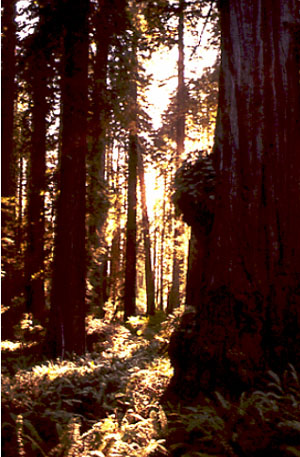
Redwood National Park has the feel of a soaring, gothic cathedral—only more so. One of the great Sequoia sempervirens trees may live for two millennia, but when it falls, new trees will grow from the fallen trunk. (Hence the scientific name, which means “ever-living sequoia” in Latin.) The redwoods are the tallest trees on Earth, commonly more than 200 feet (60 meters) and with the very tallest soaring above 379 feet (more than 115 meters). If such a tree growing on the goal line fell over, it would stretch the length of a football field and the top branches would extend into the stands at the end. Ferns growing in the duff beneath the redwoods are lost, inconsequential, despite occasionally standing shoulder-high or above. Reports from early loggers included trees even taller than any known today.
The redwoods lie in the southern part of the great, coastal, temperate rainforest that extends from San Francisco north along the Pacific coast to southeastern Alaska, and includes the Olympic National Park discussed earlier. The redwoods actually grow in soils that came from rocks much like those of the Olympic.
Redwoods are mostly restricted to a narrow band along the coast with 50-100 inches (1.25-2.5 meters) of rain per year, and with frequent to continuous fogs that slow the drying-out of the trees. The trees, in turn, help maintain the fog; cutting the trees may decrease the fog, making it difficult or impossible for the redwoods to re-grow. The wood of redwood trees is highly resistant to fire and rot, and so is greatly sought after. Logging of old-growth redwoods, thus, is a contentious issue; an estimated 96% of the old-growth forest has been cut already, and with typical ages of 500-700 years and maximum ages of about 2000 years, a new "old-growth" forest is not returning soon, but some people want to cut the remaining 4% or so of the original old-growth redwood forest. Fossil evidence shows that redwoods once were much more widespread. U.S. parks that preserve fossilized redwood include the Petrified Forest, Yellowstone, and the Florissant Fossil Beds.
A bit farther south and higher on the slopes of the Sierra, but still in a wet zone, are the great sequoias of Yosemite, Kings Canyon and Sequoia National Parks. These Sequoiadendron gigantea are close relatives of the redwoods. Although not as tall (“only” up to 311 feet, or about 95 meters), the great sequoias are more massive. The General Sherman tree, at 275 feet tall and 102.6 feet around, is generally considered to be the largest single-trunk tree on Earth (and much larger than whales and such). The great sequoias are extremely fire-resistant, and require fire to clear-out competing trees and trigger sprouting of sequoia seeds. Fire suppression instituted after the parks were established led to a period with few or no new sequoias sprouting; now, prescribed burns and procedures that allow some natural fires to burn are returning the forest to a more-natural state. Sequoias can live 3500 years.
A few hundred miles to the east of the redwoods and sequoias lies the U.S. Great Basin. All across this region of Nevada and adjacent states, rainfall typically is less than 10 inches (25 cm) per year, with Death Valley receiving just 1.6 inches (4 cm) per year on average. Sage and cactus grow here instead of towering trees - in response to the very hot, dry conditions. Yet, above the clouds, this region receives the same amount of sunshine as do the redwoods. Clearly, the climate is much more than just the amount of sunshine above the clouds. We now take a brief tour through the basics of climatology. This should help you to understand climates, weathering, erosion, and glaciers, and a number of important near-surface processes.
Why the Wind Blows
The wind blows, and the deep mantle convects, for more-or-less the same reason. Both the air and the mantle are capable of flowing, and both are heated from below and cooled from above. The amount of heating and the rate of flow are VERY different, which helps make the world interesting. But you might see a thunderstorm and imagine hot-spot formation, and there is at least a little similarity between a cold front and a subduction zone.
Anyway, on Earth, the equator receives more sunshine than the poles. Some of the energy reaching the Earth is reflected back to space from clouds or snow and ice, especially near the poles. Much more sunshine is absorbed to heat the Earth at the equator than at the poles.
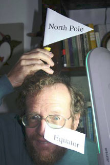
The equator receives more sunshine because of simple geometry. Imagine for a moment that Dr. Alley’s head is the Earth, with his nose on the equator and the bald spot on top the North Pole. (See the picture; you can congratulate yourself on good taste if you didn’t imagine a bad joke about the South Pole here.) If he stands in front of a sun-lamp “sun,” he’ll never get a sunburn on his North-Pole bald spot, but he will on his equatorial nose.
The Earth works the same way—at the top of the atmosphere, the amount of sunlight passing through a square meter is the same at the equator as at the pole (see the diagram below). But because of the Earth’s curvature, the light passing through a top-of-the-atmosphere square meter at the equator illuminates a square meter at the surface, whereas the light passing through a top-of-the-atmosphere square meter near the poles is spread over many square meters on the surface. (Additionally, in both cases, the rotation of the Earth spreads the light over a larger area than at the top of the atmosphere.)
This means that land at the equator becomes hotter than the poles. If we had no atmosphere or oceans, the equator would become too hot for life as we know it, and the poles too cold. However, the atmosphere and oceans take some of the excess heat from the equator to the poles, making both habitable to humans.

As the sun heats the land at the equator, the land heats the air above, and the air expands, rises, and then moves poleward in convection currents. Some of the energy in this hot air goes to warm the regions along the way, but eventually all the energy is radiated back to space. The sunlight that comes in is called shortwave radiation (because its waves are short—this stuff really isn’t that complex a lot of the time!), and the radiation going out has longer waves and is called longwave radiation. We will see later that the difference between shortwave and longwave is important in understanding the greenhouse effect. For now, note that the global energy budget is balanced—the total amount of energy brought in by short waves and absorbed in the Earth system is very nearly equal to the total amount of energy taken out by long waves to space. (At the moment, we are sending out a little bit less than we receive, and the Earth is warming, because we humans are changing the composition of the atmosphere. But, once we quit doing that, the Earth will get back to balance.) A factory balances the total amount of stuff coming in and going out, but little auto parts come in and big cars go out; the earth balances the total energy coming in and going out, but short waves come in and long waves go out. And, the uneven heating drives the wind, and the wind plus uneven heating of the oceans drive ocean currents.
Because the Earth rotates, the winds end up turning rather than going straight from equator to pole, and this makes the weather much more interesting than it would be on a non-rotating planet. If you want to explore this a little more, see the optional Enrichment.
Heating Death Valley
Some of our friends in meteorology just hate it when we say that warm air can hold more water than cool air. They like to say that the saturation water-vapor pressure in the atmosphere increases with temperature. But this means that warm air can hold more moisture than cool air.
Air is cooled in two major ways—by losing energy to its surroundings (longwave radiation to space, or warming the polar regions), or by being lifted. As air is lifted, it expands and cools. You can experience this by letting air out of a high-pressure bicycle tire, and feeling how cold the air becomes as it expands. Lifting may be caused when one air mass moves over another along a front, or when air moves over mountains. In either case, higher elevations have lower temperatures.
Cooling causes condensation of the water vapor in the air because cooler air can hold less water, and the condensation makes clouds and then rain or snow. Our friends in meteorology would point out that condensation requires cloud condensation nuclei—little dust particles and such that water drops can grow on—plus a little supercooling to get things started, or else extreme cooling if the nuclei are absent, but if you make a parcel of air sufficiently cold, clouds form and then rain or snow. (And if it bothers you that cooler temperatures exist higher, but that cold air sinks, see the optional Enrichment—there is really no problem, and it all does make sense.)
Evaporation of water requires energy. Remember that everything we see—including water—is made of fast-moving particles (atoms, or groups of atoms called molecules). The faster-moving particles are the hotter, higher-energy ones. In a pool of water (the ocean, or a drop of sweat on your brow) the faster, hotter water molecules break the attraction to their neighbors and escape, or evaporate, leaving the slower, cooler ones behind. Evaporation thus cools the remaining water. More heat then is conducted or radiated into the water from its surroundings (because heat flows from warmer to cooler places, and the evaporation has left the water drop cooler), cooling the surroundings while fueling more evaporation. This is why sweating cools a body. Condensation is the opposite of evaporation, and when condensation occurs, the heat that was added to the water to cause evaporation is released back to the air.
Now, consider a parcel of air rising up the Coast Ranges above the redwoods, and up the Sierra Nevada above the giant sequoias. As the air rises, the pressure on it (the weight of the air above) becomes smaller, and the air expands and cools. Once the air has cooled enough, it becomes saturated with water, and further cooling causes condensation. But the condensation releases some heat that partially counteracts the cooling from expansion. Air in which condensation is not occurring cools by about 1ºC for each 100 meters it is lifted, but air from which clouds and rain are forming only cools about 0.6º C for each 100 meters it is lifted (5ºF per 1000 feet dry, and 3ºF per 1000 feet wet). The difference represents the heat released by the condensation. The heat released by condensation originally came from the sun, and was stored in the air in the water vapor when water evaporated, cooling the ocean. As the vapor condenses, the sun’s energy is turned into heat that one can feel.
Strong moisture-laden breezes from the Pacific rise as they hit the redwood-clad Coast Ranges of California, cooling and raining to nourish the rainforest. The winds continue upward over the Sierra, cooling by 3ºF per 1000 feet upward, as they precipitate. By the time the wind has risen 15,000 feet to get over the high peaks, it has cooled about 45ºF (25ºC), and has rained or snowed almost all of its moisture. When this wind continues on down the other side, it is dry, and warms at the dry rate of 5ºF per 1000 feet. When this wind returns to sea level, the air has warmed about 75ºF (42ºC) on the way down. Hence, the wind comes down about 30ºF (17ºC) warmer than when it went up, and the difference is the heat that was stored when the rainwater evaporated from the ocean. A comfortable onshore breeze at 70ºF on the Pacific Coast will be 100ºF when it reaches the valleys on the other side. Add a little solar heating through the cloudless desert air, and it is no wonder that Death Valley is hot! (And yes, the wind usually goes around the Sierra rather than over, so you haven’t learned everything about meteorology in one short chapter of a geology book; but it’s a start.)
Textbook 5.2: The Badlands
Weathering, Weather, and the Badlands
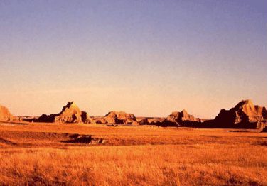
The Badlands of South Dakota are much more than just the land to the south of Wall Drug Store (“Have you dug Wall Drug?”). Today, the Badlands may be most valuable as a wonderful piece of the shortgrass prairie that once covered much of the western Great Plains. The sea of grass and flowers that nourished the bison and the native Americans of the plains has been almost entirely broken to the plow. But in the upper prairie of the Badlands, the grass still waves in the breeze like an ocean, the pronghorn still course the grass, and one can, perhaps, imagine what the prairie once was.
The Badlands are a creature of the Rockies. During one of the phases of uplift of the Rockies (especially about 30 million years ago), the exposed rocks were first weathered (changed into other forms, such as clay), and then transported from the mountains onto the plains to the east, or on down the Mississippi River system to its delta. Those sediments deposited on the Great Plains piled up until the mountains were almost completely buried, and an unbroken ramp of sediments extended to the Mississippi. The sediments were mostly river deposits, on flood plains or in channels of rivers, although some ash-falls from volcanoes and other wind-blown sediment were present.
Eventually, renewed uplift of the Rockies rejuvenated the streams draining through the Badlands, causing these streams to cut down through the older deposits. In these deposits are uncounted fossils of the animals and plants that lived on those floodplains. The fossils tell a story of gradual drying from wetter times of the past, and of changes in the types of things living there.
The types of clays and volcanic ashes in the Badlands, combined with the climate in which they now occur, do not make fertile, stable soils. The clays expand and shrink on wetting and drying, breaking roots, triggering small landslides, and helping keep the slopes unvegetated. Water doesn’t flow easily through clay, so rainfall doesn’t soak in but flows rapidly across the surface during the rare but intense rainstorms, eroding channels in the clays and washing away vegetation; this also leaves the soils dry between rainfalls so that plants have difficulty sustaining themselves.
That a lush prairie can grow on the flatter regions is testament indeed to the hardiness of the prairie ecosystem. But, on steep slopes, the pastel-colored muds eroded from the old Rockies are exposed, along with the fossils they contain. We will explore stories of this sort over the next few weeks. We start with weathering, the changes that can turn hard rocks to soft clays of the type observed in the Badlands.
Weathering Processes
Squeezing mud, perhaps with a little heating, produces a sedimentary rock called mudstone or shale, and with further heating and squeezing this rock changes to various other things on the way to melting (you may have met shale→slate→schist→gneiss somewhere; we saw gneiss in Rocky Mountain, and all of them in the Enrichment, last time). The materials in mud are stable (or at least nearly so) under Earth-surface conditions but not deep in the Earth. And minerals produced deep in the Earth usually are not stable under surface conditions. Compared to deep in the Earth, the surface is wetter, has more oxygen, has a wider range of acid/alkaline conditions (with acid especially common at the surface), and has many more organisms trying to break down the minerals to extract fertilizer.
As a general rule, the further surface conditions are from conditions under which a mineral formed, the more rapidly that mineral changes at the surface. (This “rule” has many exceptions, but it is often useful, especially with silicate minerals.) The changes that occur at a place are called weathering. Moving the products of weathering is called transport. Weathering and transport together make erosion.
Weathering in turn is divided into mechanical and chemical weathering. Mechanical weathering is the making of little pieces from big pieces; chemical weathering is the making of new types of materials that were not there previously.
Mechanical Weathering
To turn big pieces into little ones, the big ones need to be cracked. Cracks in rocks are caused or enlarged by processes including:
- Mountain-building stresses, or earthquake-release stresses, breaking the rocks;
- Expansion and breakage of rock as the weight of overlying rock is removed during erosion of that overlying rock;
- Expansion and contraction during heating and cooling (especially very near the surface during forest fires);
- Growth of things in cracks (tree roots, minerals).
Probably the most important mineral that grows in cracks is ice, but others do too. For example, the mineral thenardite, Na2SO4 (no, you don’t have to memorize the formula!) can add much water to its structure (10 molecules for each Na2SO4), expanding in the process. If thenardite exists in an environment that alternately is wetted and dried, the resulting expansion and contraction from adding and losing water may break the rocks around it. Increased humidity will cause the mineral to rearrange and take up water, expanding and wedging open cracks. Continued wetting may dissolve the mineral, which will move deeper in the crack in the rock and then be redeposited and dehydrated during a subsequent dry time. Then further wetting will cause re-expansion and more wedging. This process is breaking many of the ancient monuments of Egypt as increased irrigation and other activities increase humidity in some places.
Chemical Weathering
Chemical changes are often more interesting and more complex than physical ones. There is a great range of possible changes, and you must know a lot of chemistry to really appreciate all of them. In general, the main agents of weathering are weak acids. Rainwater picks up carbon dioxide from the air and becomes a weak acid called carbonic acid. In soils, water may pick up more carbon dioxide plus organic acids from decaying organic material, becoming a stronger acid.
When acid attacks a rock, the results depend on what minerals are present, and how warm and wet and acidic conditions are, among other things. We can sketch some general patterns. Suppose we start with granite, a silica-rich rock that forms in a few continental and island-arc settings, including when bodies of melted rock solidify beneath the andesitic volcanoes of subduction zones.
Granite usually is composed of four minerals: quartz (pure silica, which is silicon and oxygen), potassium feldspar and sodium-calcium feldspar (mostly silica, with a little aluminum replacing some of the silicon, and the potassium, sodium or calcium added for balance), and a dark silica-bearing mineral containing iron and magnesium (often a dark mica called biotite). Interestingly, almost 99% of the atoms in the rocks of the crust of the Earth are oxygen, silicon, aluminun, iron, calcium, sodium, potassium or magnesium, the common elements in granite. We discuss granite here because it does so well representing the whole crust.
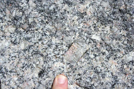
When granite interacts with carbonic acid, several things happen.
- Iron (Fe) rusts. It picks up water and oxygen, and remains in the soil as little pieces of rust.
- The aluminum (Al), potassium (K) and silica (SiO2) from the feldspars and from the dark mineral rearrange into new minerals, called clays, that also include some water.
- The calcium (Ca), sodium (Na) and magnesium (Mg) dissolve in water and wash away.
- Most of the quartz (silica as a mineral) sits there almost unchanged as quartz sand (a little of it may dissolve and wash away, but most stays).
One can write a sort of equation:
Granite → quartz sand + clay + rust + (dissolved-and-washed-away Ca + Na + Mg).
The calcium and silica dissolved and washed to the ocean are used by sea creatures to make shells, the dissolved magnesium washed to the ocean usually ends up reacting with hot rocks at spreading centers to make new minerals in the sea floor, and the dissolved sodium accumulates in the ocean to make it salty. (Eventually, evaporation of ocean water in restricted basins causes deposition of salts including table salt, which is sodium chloride, written NaCl. Also, some salt is taken down subduction zones with the water in the spaces in sediment. So, the ocean does lose sodium as well as gaining sodium.) The rust, sand, and clay left behind, plus a little organic material often including worm poop, become the indispensable layer we know as soil.
You should recognize that this is a very general description of what happens; were it this easy, there would not be hundreds of soil scientists working to understand this important layer in which most of our food grows. In general, the hotter and wetter the climate, the more stuff is removed—rust and quartz sand can be dissolved in some tropical soils, leaving aluminum compounds that we mine for use in making aluminum. In dryland soils, the Ca and Mg may be left behind (forming special desert soils), or even the Na may be left behind, forming salty soils in which little or nothing will grow.
You also should recognize that the “chunks” in soil – rust, clay, sand and organic materials – can be carried away by streams or wind, but as chunks rather than invisible dissolved materials. We discuss this loss of chunks in the next sections. If chunks are carried away more rapidly than new ones are formed, the soil will thin and we will find it difficult to grow food to feed ourselves.
When we were looking at subduction zones, we noted that old, cold sea floor goes down. We now see that it takes some extra magnesium, added from sea water by reactions with the hot rocks at the mid-ocean ridges. Sediment goes down subduction zones, including the calcium- and silica-bearing shells of sea creatures, the rust and clay washed from the continents, and some sea water. When these melt and feed volcanoes, andesite and similar rocks are made during eruptions, or their underground equivalents including granites are produced. The calcium-bearing shells include carbon dioxide, and this plus water escape from the volcanoes to make carbonic acid to attack the new granite. The Earth really does cycle, and recycle, everything! But, going around this loop once takes at least millions of years, and may take a lot longer than that, issues we'll discuss later.
Textbook 5.3: The Grand Tetons
Another Reason Why Loose Rock Matters: Mass Movement and the Grand Tetons
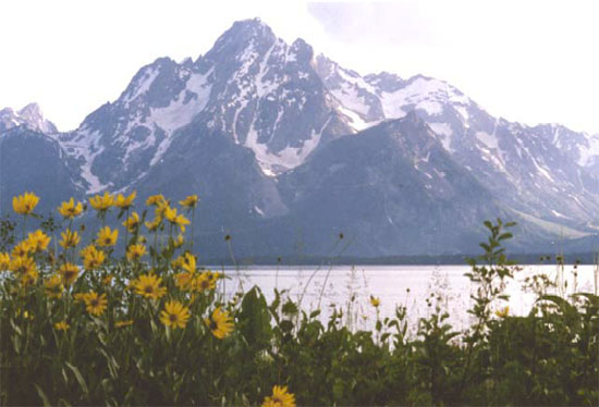
The Grand Tetons tower above Jackson Hole, Wyoming, the epitome of western scenery for many people. A steep pull-apart fault lies along the front of the range and slopes downward beneath Jackson Hole. From the highest peaks to the Hole is well over a mile (roughly 2 km), but the total offset on the fault (including material eroded from the top of the range and deposited in the valley) is almost 6 miles (10 km). The uplifted block is primarily old metamorphic rocks that erode only slowly. The faulting is probably related to the Basin and Range extension that also gave us Death Valley, although the complexity of the region makes any interpretation difficult. Dr. Alley recalls huddling next to an overhanging rock, far up on the steep front of the Tetons, watching hailstones rattle off the trail from a black deck of clouds barely over his head. It is a truly awesome place.
 \
\
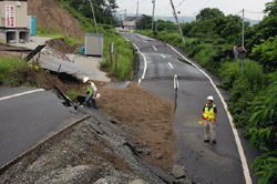
A few miles (few km) east of the park is another interesting feature: the Gros Ventre slide. There, the rock layers slope steeply under a long ridge or mountain, with the layers almost parallel to the mountainside, down to the Gros Ventre River. Strong, resistant sandstone rests on weak, slippery shale. The river has eroded down through the sandstone and into the shale, leaving the toe of the sandstone unsupported. In June 1925, after a particularly wet spring, the entire mountainside let loose, sliding down and across the river. The slide mass made a dam, trapping a lake miles long and 200 feet (60 m) deep. The entire slide probably required only seconds to occur, and moved cubic miles (many cubic kilometers) of rock.
Such a debris dam is not very strong; water flow through its pore spaces or over it can remove rocks and weaken it greatly, until it collapses catastrophically. When we were discussing earthquakes, we saw that a similar slide happened during an earthquake in 1959 just northwest of Yellowstone, damming a river to form a new lake, and that the Army Corps of Engineers had rushed in to prevent collapse of the dam. The Corps had learned from previous experience, including events at Gros Ventre. In 1925, efforts were not made to stabilize the dam there. It collapsed two years later, washing out a small town downriver and killing six people.
Moving Masses
The Gros Ventre slide is an especially dramatic example of an important but usually-more-boring process: mass movement. This is the name give to the downhill motion of rock, soil, debris, or other material, provided the flow is not primarily water (if material is washed along by a river, we call it a river), or a glacier or wind.
Water is usually involved in mass movement, however, because most mass movements occur when soil or rock is especially wet. This happens for four reasons: water makes the soil heavy; water lubricates motion of rocks past each other; water partially floats rocks (a rock pushes down less in water than in air) so they are not as tightly interlocked and can move more easily past each other, and saturation of a rock mass removes the effect of water tension.
This last deserves a bit more explanation. Think about going to the beach and building sand castles. Dry sand makes a little pile with sides rising at maybe 30 degrees. Totally saturated (wet) sand flows easily, forming a pile with a much more gradual side. But damp sand can hold up a vertical face. You can even make and throw damp sand balls (be careful where you throw them).
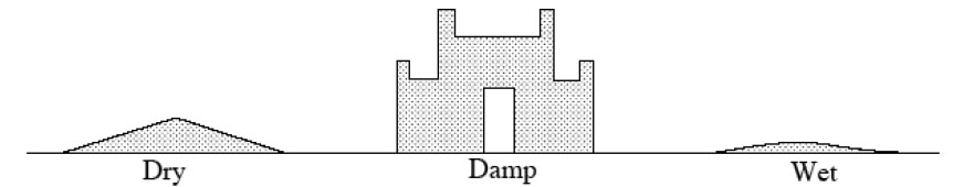
The details of the surface physics involved are a bit complicated, but basically, a drop of water will sit at the junction of two sand grains. Pull the sand grains apart, and some water will end up on each grain. This requires “breaking” the water; what had been one continuous film of water is now broken into two. Next, think of a dripping faucet. A water drop doesn’t fall off immediately, but first becomes large and heavy. Clearly, water has strength, and does not “like” to be broken. (This strength arises from the attraction of water molecules for each other, and is usually called surface tension.) Damp sand thus is strong—a landslide would require some sand to move rapidly past other sand, breaking the water bonds between the grains. In fully wet sand, however, the grains move about in the water without ever breaking it, so motion is easy.
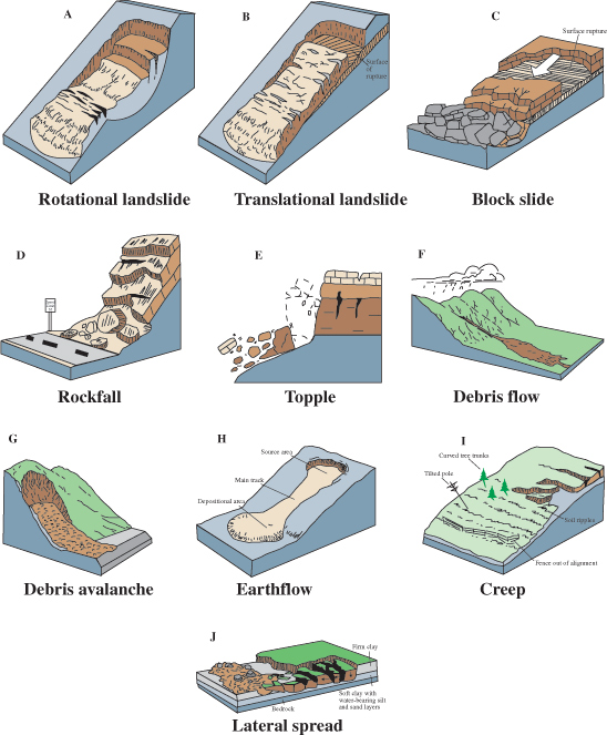
There are elaborate classifications of mass movements, depending on how fast, how wet, how coarse, how steep, and how "other" they are. Most of the names make sense: falls are rocks that fell off cliffs, topples are rocks that toppled over from cliffs, landslides and debris flows and debris avalanches are fast-moving events, and slumps are failures of blocks of soil along concave-up curved surfaces, something like a person slumping down in a chair.
One fascinating, and scary, type of mass movement occurs on “quick” clays. These are clays usually deposited beneath the sea, in which the playing-card-shaped clay particles exist in a house-of-cards structure stuck together by ions of the sea's salt, which sit in the spaces between clay particles. When raised above sea level, ordinary water begins to replace the ions of the salt, and the structure becomes weaker. Eventually, it may fail catastrophically, going from a solid to a very thin liquid almost instantaneously, and generating a flow. Flows from such clays are known especially from parts of Canada and Scandinavia. Such a flow crossing a road can pose a problem, because bulldozing the clay out of the way does little good; more just flows across. But throwing a bag of salt into the flow near the road and driving a tracked vehicle through to mix the salt and clay may cause the flow to solidify so that it can be bulldozed away. Tragically, large portions of some towns have been destroyed, with much loss of life and property, when such quick clays have failed under buildings. Fortunately, these are quite rare.
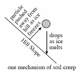
The most important mass-movement type in terms of transferring material downhill is soil creep, the slow (typically inches, or centimeters, per year or less) downslope motion of soil. Creep may be a very slow landslide. It may occur from freeze-thaw processes—a column of ice that grows under a small pebble on a cold night pushes that pebble out from the hillslope, and the pebble falls straight down when the ice melts, effectively moving a tiny distance down the hill (see the figure above). When trees fall over and uproot soil, or when groundhogs and even worms dig out rock grains and allow them to move downhill, creep is occurring. If you look at a typical hillslope, streams on the lower slopes are present to move water and rock downhill, but the upper slopes lack streams. There, soil creep serves to move material downhill.
Hillslopes typically reach a balance, in which weathering breaks down rocks about as rapidly as mass movement and streams take the broken rocks away. The balance may occur with bare rock sticking out (as in some cliffs, for example), or with a lot of soil covering the rock. If soil creep dominates the mass movement, the hillslope may always be close to balance. If landslides dominate, then the soil will build up for a long while before suddenly slumping off, and you have to watch for a long time to see that formation and transport of soil are in balance. And, over very long times, the hill will eventually flatten, causing the mass movement to slow. However, soil will very gradually thicken to slow the weathering as the hillslope is reduced, and near-balance will be maintained.
Humans are greatly upsetting this balance worldwide. Our activities—bulldozing, cutting trees whose roots held the soil, plowing, and more—are moving more material than nature moved before we were involved.
Virtual Field Trips
Join Dr. Alley and his team as they take you on "virtual tours" of National Parks and other locations that illustrate some of the key ideas and concepts being covered in Unit 5.
TECH NOTE - Click on the first thumbnail below to begin the slideshow. To proceed to the next image, move the mouse over the picture until the "next" and "previous" buttons appear ON the image or simply use the arrow keys.
Virtual Field Trip #1: Good Things in the Badlands
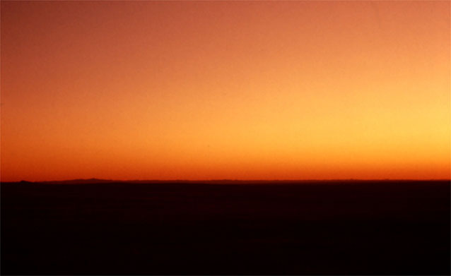
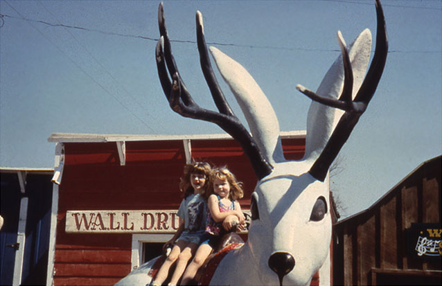
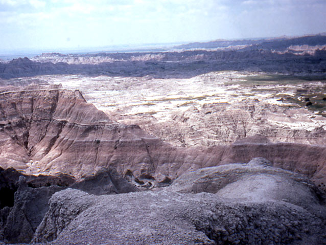
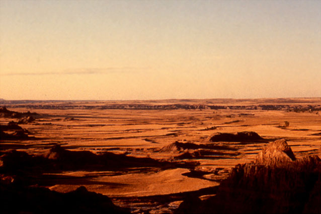
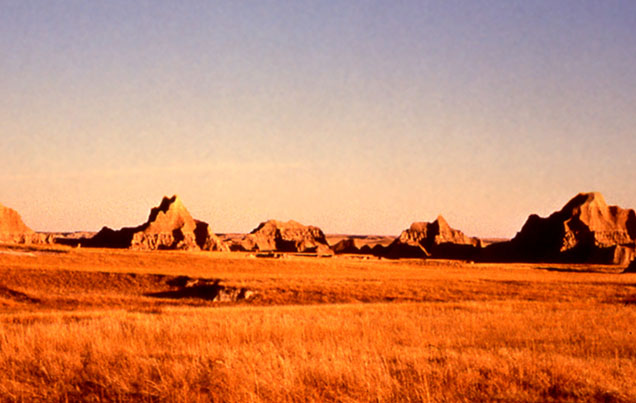
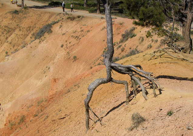
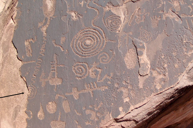
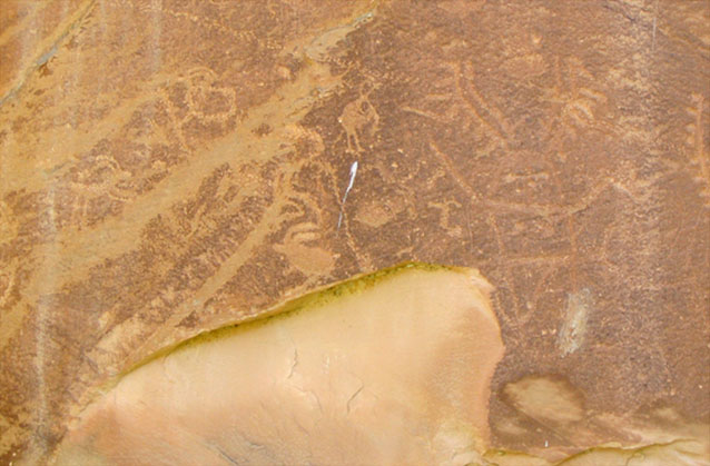
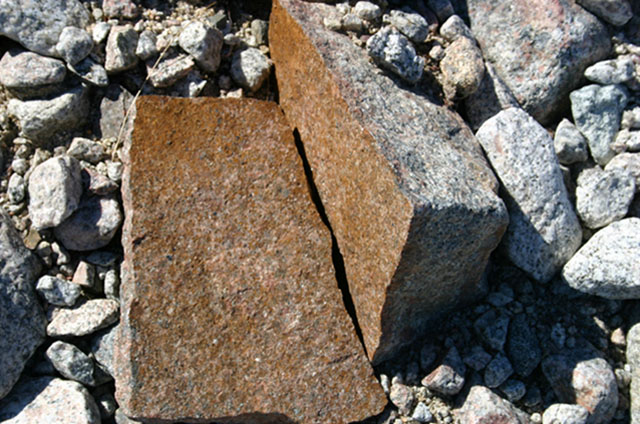
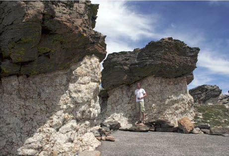
Image 1: Sunrise over the Badlands. A first look at breaking rocks to make sediment, and transporting that sediment to make beautiful and informative places.
Image 2: Children sitting on jackalope statue at Wall Drug tourist area in Badlands. Most folks who drive to the Badlands are enticed by the seemingly endless signs for a particularly well-known tourist trap, shown here.
Image 3: Badlands rock landscape. The badlands are muds and sand beds put down by ancient rivers draining the Rockies, together with volcanic ashes blown in on the wind. All of these materials were made by the breakdown of older rocks in the Rockies.
Image 4: Badlands clay landscape. The clays of Badlands soils expand and contract as they wet and dry, tearing out plant roots. Flat areas maintain vegetation, but steep areas are mostly bare sediment.
Image 5: Large weathered rocks in Badlands. Breakdown of rocks to make smaller pieces and new types such as clay minerals is called weathering. Movement of these smaller pieces is called transport. Together, weathering and transport make erosion.
Image 6: Tree roots in Bryce Canyon exposed by soil erosion. Finding evidence of erosion is not hard. This tree, on the rim of Bryce Canyon, started with its roots covered by soil, but the soil has eroded away. The very soft, steep rocks here have eroded by more than a foot in the few decades of this tree’s life.
Image 7: Ancestral Puebloan rock carving showing surface flaking. Arrow points to half-spiral. Petrified Forest National Park. Ancestral Puebloan people carved this rock in Petrified Forest National Park almost a millennium ago. A little of the rock surface has flaked off since then; the artists did not carve a half-spiral on the left (arrow added).
Image 8: Ancestral Puebloan rock carving damaged by fall of rock. Petrified Forest National Park. As in the previous picture, the thousand-year-old artwork of Ancestral Puebloan people has been damaged a little by fall of rock, showing that rocks do change, but slowly.
Image 9: Rock split in two as a result of frost grown in crack. Coast of Greenland. And in a very different environment, in the remoteness of the coast of Greenland, frost growth in a crack has split this rock in two. The rock is in the deposits from about 1850, and most of its surrounding rocks have not been split, giving some insight to the rate of weathering.
Virtual Field Trip #2: The Redwoods and Death Valley
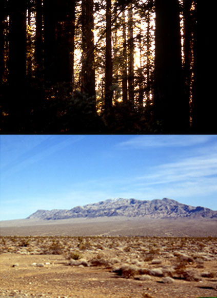
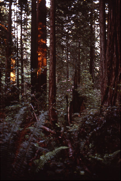
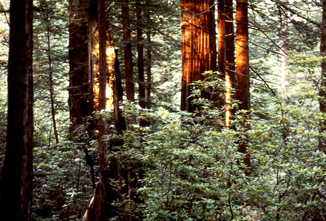
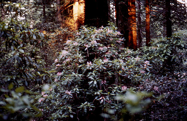
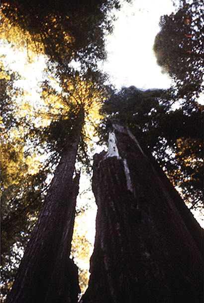
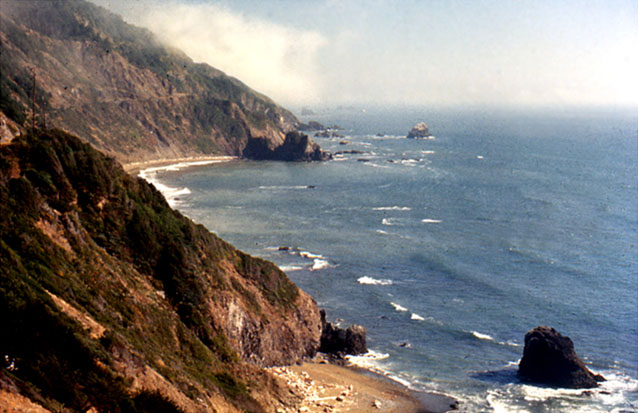
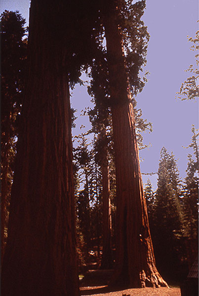
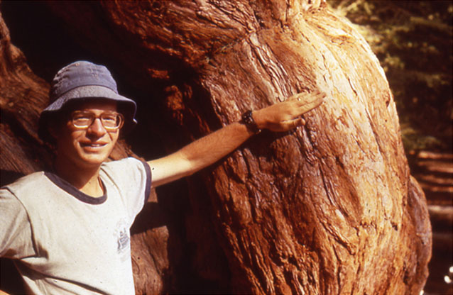
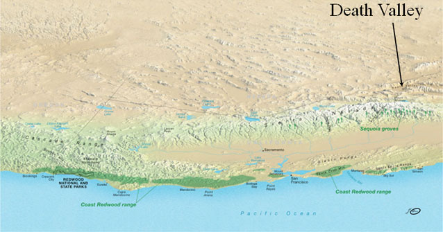
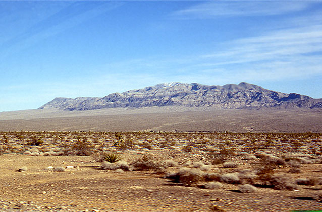
Image 1: Two contrasting photos. Top photo of Redwoods, bottom photo of Death Valley. A Contrast in Weather… Redwoods and Death Valley. Some pretty pictures by R. Alley, with a message at the end.
Image 2: Close-up of Sequoia trees in Redwood National Park. Redwood National Park is another of the parks established primarily for biological reasons. Sequoia sempervirens, the ever-living sequoia, will live for two millennia, and then sprout new trees from its fallen trunk.
Image 3: Redwood forest, with ferns, rhododendron and azaleas in the understory. The redwood forest, with ferns, rhododendron and azaleas in the understory, look like a magnified version of an eastern hemlock forest.
Image 4: Rhododendron in Redwoods. The acids in redwood needles help produce soils that favor rhododendron (shown here) and ferns, as well as more redwoods.
Image 5: Sequoia tree standing more than 370 feet tall. Reaching heights of more than 370 feet (well more than a football-field standing on end), the redwoods are the world’s tallest trees.
Image 6: Ocean view at the Redwood coast. The redwood coast is rainy and foggy; the huge trees couldn’t exist in a drier environment. The coast is also beautiful.
Image 7: Giant Sequoias representative of those found in Yosemite, Kings Canyon and Sequoia National Parks. Up the mountains from the redwoods are the giant sequoias of Yosemite, Kings Canyon and Sequoia National Parks. Although not as tall as the redwoods, these trees are more massive--generally considered the largest living things on Earth--and live more than a millennium longer.
Image 8: Close-up of man standing next to Sequoia tree, showing thick bark. The thick bark of the sequoias is nearly fireproof. The trees need fire to clear out faster-growing trees so young sequoias have room to grow, and to trigger sprouting of those young sequoias.
Image 9: Death Valley landscape. At about the same latitude as the sequoias and redwoods, and with the same sunshine above the clouds, is Death Valley and the rest of the Great Basin. This huge weather difference is discussed in the textbook--Death Valley is warmed by tropical sunshine, set loose by redwoods rain.
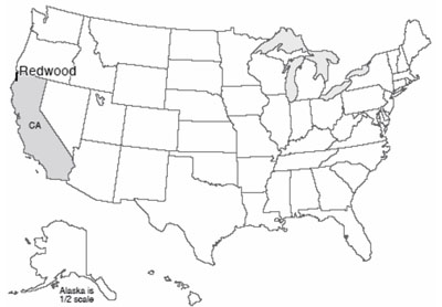
Image 10: Topographical map showing Coast Redwood range with arrow pointing to Death Valley behind the mountain range. Link: http://data2.itc.nps.gov/hafe/hfc/carto-detail.cfm?Alpha=REDW# [4] At about the same latitude as the sequoias and redwoods, and with the same sunshine above the clouds, is Death Valley and the rest of the Great Basin. This huge weather difference is discussed in the textbook--Death Valley is warmed by tropical sunshine, set loose by redwoods rain.
Virtual Field Trip #3: The Grand Tetons!
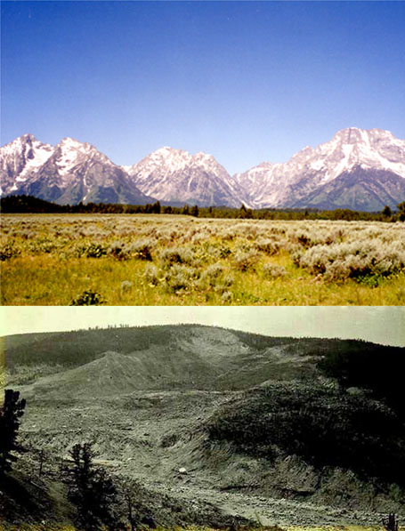
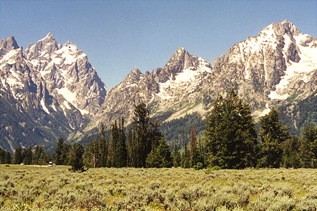
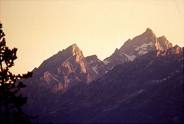
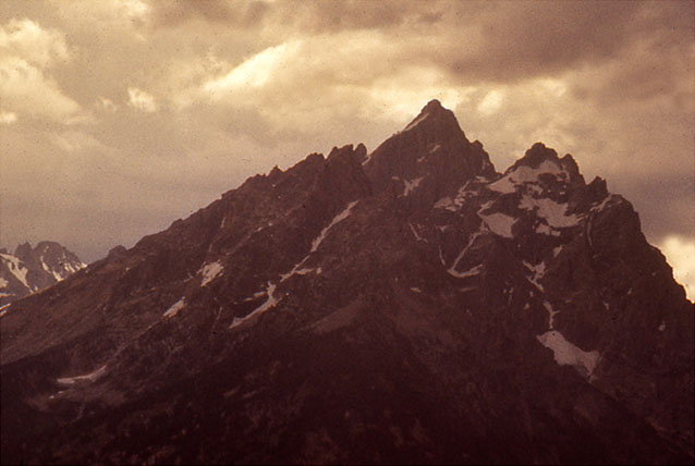
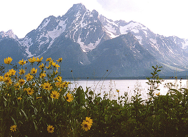
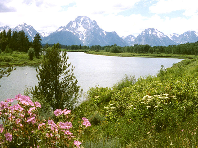
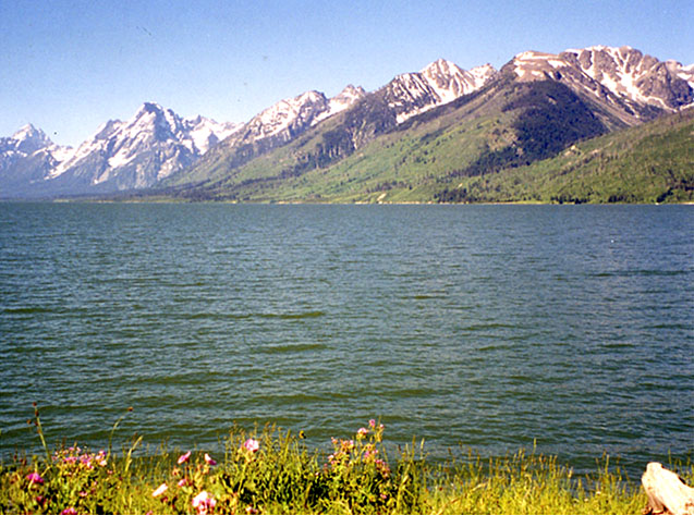
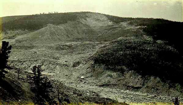
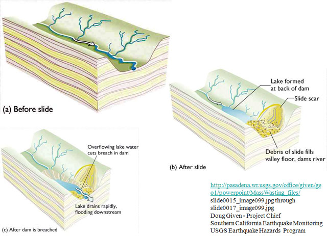
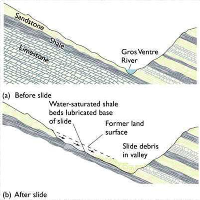
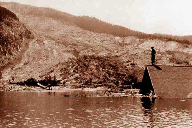
Image 1: Two contrasting images: Top photo of Grand Tetons. Bottom photo of Gros Ventre slide. (Top) The Grand Tetons--Surely one of the finest views in the west (Bottom) And the Gros Ventre slide--A reminder that the west is ever-changing.
Image 2: The Grand Tetons with evergreens in the foreground. The Grand Tetons. This is real mountain scenery.
Image 3: Close-up of Grand Tetons showing pull-apart-type faulting. Pull-apart-type faulting has dropped the valley and raised the mountains a total of several miles.
Image 4: Close-up of Grand Teton peaks with dark thunder clouds above. Rockfalls are common, especially during intense summer thunderstorms.
Image 5: Mount Moran with Darn Yellow Composites (wildflowers) in foreground. Mount Moran is framed by summer wildflowers (DYCs, or darn yellow composites, because yellow composites are often so hard to identify accurately).
Image 6: Oxbow Bend with view of Mt. Moran and other Tetons in the background. Oxbow Bend is a favorite site for viewing Mt. Moran and the rest of the Tetons.
Image 7: Grand Tetons with lake in the forefront. Numerous lakes, many glacier-carved, dot the park.
Image 8: Gros Ventre slide, near the Grand Tetons. Historical photograph of the Gros Ventre slide, near the Grand Tetons.
Image 9: Cross-section drawings of before Gros Ventre slide, after the slide, and after dam is breached.
Image 10: Valley cross-section drawing showing geological setting of the Gros ventre slide. Valley cross-section showing geological setting of the Gros Ventre slide.
Image 11: Historical photo of lower slide lake shows a person standing on the roof of a submerged building. Historical photo of lower slide lake. Catastrophic drainage of the slide-dammed lake destroyed the town of Kelly, killing six and destroying the hotel, mercantile store, automobile garage, blacksmith shop, livery stable, and homes, but sparing the Episcopal Church and local school.
Virtual Field Trip #4: Landslides!
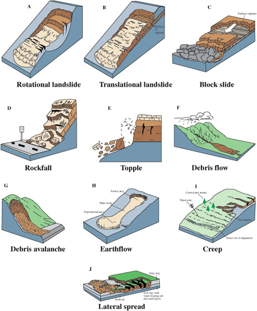
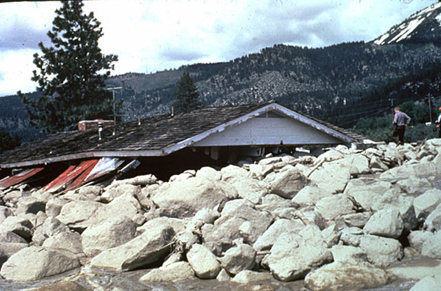
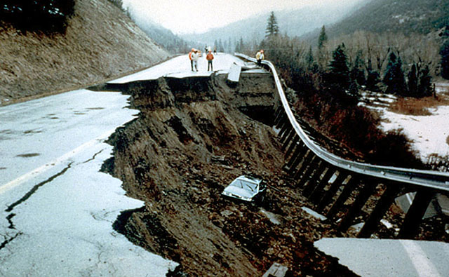
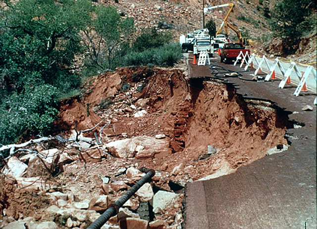

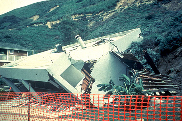
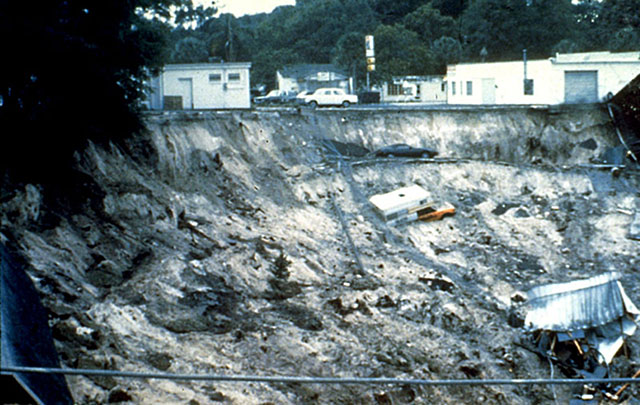
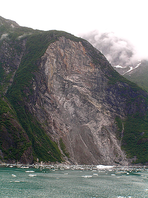
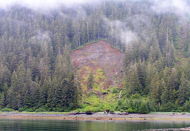
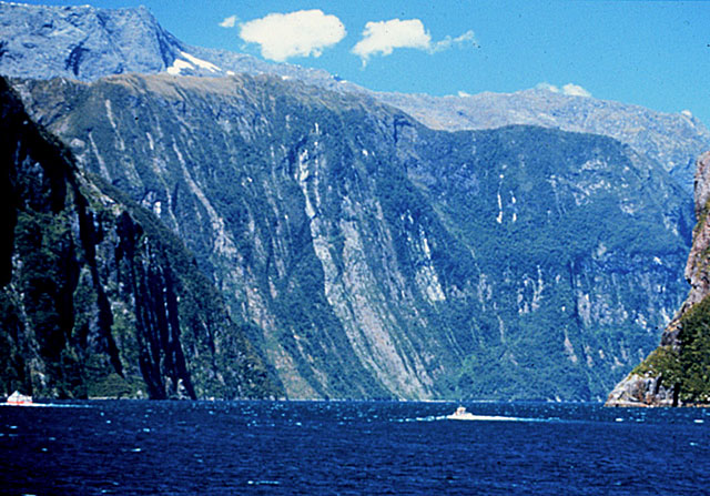
Image 1: Drawings labeled A through J representing 10 types of mass movements. http://pubs.usgs.gov/fs/2004/3072/images/Fig3grouping-2LG.jpg [12]. There are many types of mass movements, ranging from hundreds of miles per hour to less than an inch per year, and from whole mountains to single grains of sand.
Image 2: Slide Mountain, Nevada. House buried beneath slide, only roof above surface. http://landslides.usgs.gov/html_files/landslides/slides/slide2.htm [6]. Slide Mountain, Nevada. Snowmelt-triggered debris flow, May, 1983, killed one and injured several. USGS had publicly identified the hazard a decade earlier, but good science is often ignored.
Image 3: A car in the mud of a 1994 landslide near McClure Pass, Colorado. http://landslides.usgs.gov/html_files/landslides/slides/slide11.htm [7] Photograph by Terry Taylor, Colorado State Patrol. Landslide near McClure Pass, Colorado, 1994. The driver did not see this nighttime slide in time to stop, but fortunately was not injured
.Image 4: 1995 Landslide under the only road to lodge of Zion National Park. http://landslides.usgs.gov/html_files/landslides/slides/slide19.htm [8]. Photograph by R.L. Schuster, USGS Landslide under the only road to lodge of Zion National Park, April, 1995, stranded 100 people for two days. The broken sewer pipe, shown in lower part of photo, didn’t help.
Image 5: Aerial view of 1995 landslide at La Conchita, California along highway 101. http://landslides.usgs.gov/html_files/landslides/slides/slide21.htm [9]. Photo by R.L. Schuster, U.S. Geological Survey. Spring, 1995 landslide at La Conchita, California, south of Santa Barbara along highway 101. Many homes were destroyed, but no one was injured.
Image 6: Home crumbled and destroyed by La Conchita, California slide. http://landslides.usgs.gov/html_files/landslides/slides/slide24.htm [10] Photograph by R.L. Schuster, U.S. Geological Survey Home destroyed by La Conchita, California slide from previous picture.
Image 7: 1981 Winter Park, Florida sink hole opening. Car, truck and destroyed building in the sink hole. Caption: http://landslides.usgs.gov/html_files/landslides/slides/slide10.htm [11] This is the Winter Park, Florida sinkhole, which opened in one day in 1981. We’ll return to sinkholes when we visit caves, which occur with sinkholes.
Image 8: Half-mile-high landslide scar, Tracy Arm/Ford’s-Terror Wilderness Area, Alaska. Caption: Half-mile-high landslide scar, Tracy Arm/Ford’s-Terror Wilderness Area, Alaska. Steep slopes caused by mountain building or rapid erosion (in this case, by glaciers) often fail catastrophically. A slide similar to this made the immense tsunami in nearby Lituya Bay that we discussed last week. Photo by R. Alley
Image 9: Landslide near Sitka, Alaska. Caption: Most landslides don’t make the news, such as this one near Sitka, Alaska. Photo by R. Alley.
Image 10: Numerous landslides on the mile-high, glacially carved cliffs in Milford Sound, New Zealand. Caption: Milford Sound, New Zealand. The numerous landslides down the mile-high, glacially carved cliffs give it the pretty, striped appearance. Photo by R. Alley.
Word Document of Unit 5 V-trips [13]
Want to see more?
Here are some optional vTrips you might also want to explore! (No, these won't be on the quiz!)
Death Valley National Park [14]
(Provided by UCGS)
Grand Tetons National Park [15]
(Provided by UCGS)
GeoMations and GeoClips
There is one GeoMation and there are four GeoClips available for your viewing in this unit. Hopefully, you'll find this helpful in understanding Unit 5 just a little bit better.
GeoMation:
So out here there's the great Pacific Ocean. And the wind comes trucking in from the Pacific Ocean. And it's just going great guns, except at some point it runs into the giant mountain range of the Sierra, which we know goes up over the top and down the other side and down to Death Valley.
And so when the air runs into that, the air has to rise. And you may know that when air has to rise, it expands. And when you have air expanding, whether it be out here on the Pacific or from a bicycle tire, it cools. And when the air cools, that makes nice clouds. And when that makes clouds, that makes rain that comes dripping down. And so sitting underneath that, as you might imagine, you have really wonderful trees called the Redwoods because it rains like crazy on them. And they're really happy with that.
Now the air is cooling, and the cooling rate is something vaguely about three degrees Fahrenheit for each 1,000 feet that the air goes up. It should be five, five is the thermodynamics. But when the cooling causes condensation that makes the rain that we see, condensing actually gives up a little heat. And so you only get a cooling of about three degrees Fahrenheit per 1,000 feet going up.
Now, when the air comes over the top and starts coming down the other side, there's no water in it to evaporate. There's no water there, it's dry. And when air is coming down like that and being squeezed, it ends up warming. And that warming is about five degrees Fahrenheit per 1,000 feet that it comes down.
And so it cools going up at about three degrees Fahrenheit per 1,000 feet. It warms coming down five degrees Fahrenheit per 1,000 feet. And that in turn means that because the mountains are really high, that if the air comes trucking in at something like 70 degrees Fahrenheit, by the time it goes over 15,000 foot high, it's almost 15,000 feet to the top of the Sierra, and the air has to get over, why when it comes back down here to Death Valley, it is 100 degrees Fahrenheit. And you really would be wiser to go visit in the winter rather than in the summer.
GeoClips:
We can measure the uplift of mountains, which may occur slowly, or suddenly in earthquakes, and we can watch volcanoes erupt. But overall, nature tears down mountains about as rapidly as they form, and we can watch and measure the tearing-down, too. The slow disappearance of names from old tombstones, the hubcap-rattling holes in late-winter city streets, and the maintenance budget for university buildings all attest to the effects of nature on human-made things. Here, Dave Witmer takes you to Bryce Canyon, one of the many, many places where you can see nature removing natural things.
Erosion at Bryce Canyon National Park
Hi, I'm standing here up at the top of Bryce Canyon. And right over here we have a great example of how quickly erosion takes place here. As you can see, the roots of this tree are exposed. And this tree is only about 100 years old, but it looks like it's trying to jump out of the ground. And that's because of the ground that was up here has been washed down the canyon exposing the tree's roots. Luckily for this tree, the roots go very deep into the ground to get all the moisture it can. And that's why it's still able to surviv.
Geologists observe the wear-and-tear of nature on human-made and natural things, gaining clues to help understand how mountains are torn down. When climbing the sheer cliffs of Zion National Park into the mysterious crevice of Hidden Canyon, the intrepid hiker clings to a rather precarious-looking chain to avoid falling into the stream-carved potholes just beside the trail, and on down to the Virgin River, in the Canyon a hair-raising drop below. In these two clips, Dave Witmer and Dr. Anandakrishnan show how rocks are worn away, a little at a time, and what this has to do with south-Indian cuisine. You might begin thinking about what this wearing-away of rocks has to do with the Virgin River in the Canyon far below.
Chain of Events / Zion National Park
Hey Sridhar, look here.
What's going on there?
The chain that we are using to climb up the hillside here in Zion is actually causing some mechanical weathering. And you can see how everybody that grabs on to the chain as it goes up--
Ah, cool. Check it out.
It carves into here. It actually carves into the sandstone.
It's made these little scallop marks where the chains that are turned in this way go in a little bit deeper. And the chains that are out that way are back a little bit farther.
Yep. It would be just like a rock in a stream or even a glacier pushing stuff along. It's just scooping things up at a constant pressure along the side of the rock.
And so this stuff is actually fairly friable. It breaks apart reasonably easily. This chain's probably only been here 10, 15 years. And already it's cut in, what 1/25 of an inch, an 1/8 of an inch, something like that.
Pothole Grinding / Zion National Park
[MUSIC PLAYING]
So the water came along this way and carved out those holes coming around the bend. And then as it started to make the corner, it came down and it swirled around in these big holes. Probably, you can even see down there, there's some pebbles stuck in there and gravel size bits. And in a big flood, it would carry those size rocks and larger, bring them down.
And it's just like my grandmother grinding rice to make dosas and idlis which are these magnificent South Indian dishes, where you take rice, you put them down in a mortar and a pestle, and you just grind them around, add a little bit of water, grind them around. And you get this wonderful flour that comes out of it. That's the exact same thing happening here.
The water comes pounding down, carrying rocks, and it swirls them around because it's making the turn. And it's going fast enough that as it makes a turn it can't just go straight, it's got to curve around. It's just beautiful, it's magnificent. And we can even see some of the rocks left down in there from the last time we have a flood coming through here.
Rocks and soil on hillsides really do slide down, whether rapidly or slowly, in big chunks or small ones. When a river erodes downward to make cliffs in the riverbank, or when a volcanic eruption or an earthquake makes a cliff, rocks fall or creep or slump or are washed off the steep slope, smoothing it over time. Here, Dr. Alley shows this for a tiny "canyon" in the bottom of the truly Grand Canyon.
Making a Sand Canyon / Grand Canyon National Park
[MUSIC PLAYING]
If you make a canyon, and you deepen that canyon, the sides fall in. And one can see the sides avalanching in there merrily, eating back over time. See waves of adjustment going on. It's really beautiful to see.
I steepen it, and it steepens at the bottom. And then it eats its way back, and then it eats back at the head, eventually. Well, that's exactly what's going on here.
And so we can see across the river. The river is cut down. And then above it, there's that slope of rocks that have fallen off of the cliff. And as the river cuts down, that slope will be lowered and rocks will fall off of it and come avalanching down in exactly the same way as what we're seeing going on here in a very small scale. And you'd see all these little waves and nick points, and there are quite a number of very exciting things going on here.
Want to see more?
Enrichment: More movies for you to enjoy—and these two won't be on a quiz. Erosion has carved fantastic forms from rocks, and weathering is important in loosening pieces to be transported away. Here, National Park Service Ranger Jan Stock and the CAUSE students explore weathering in Bryce National Park, and then Dr. Richard Alley explains changes at Delicate Arch in Arches National Park.
Bryce Windows and the Freeze/Thaw Cycle [16], (Transcript [17])
Forming Arches [18] (Transcript [19])
Here are some optional animations you might also want to explore! (No, these won't be on the quiz!)
Soil Erosion [20]
(An extensive collection of animations on this subject)
Mass Wasting/Landslide Animations [21]
(An extensive collection of animations on this subject)
Video Lecture
The Unit 5 lecture features Dr. Sridhar Anandakrishnan and is 57:43 minutes long.
Good morning. Welcome to GSCI 10, Geology of the National Parks. Now for the next two or three classes, we're going to be looking at how we tear down mountains. For the first part of this class, for the last four lectures, we've been building these mountains.
And just to do a real quick recap, if you remember, it's all driven by heat inside the earth. And where does that heat come from? From radioactive decay. All right, so radioactive decay inside the earth drives the heating or produces the heat, which then drives these convection cycles inside the asthenosphere. So the hot rocks rise up, get to the surface, cool off, sink back down again. And these big cycles go on inside the asthenosphere.
Up at the surface, in the lithosphere, that's broken up into 8 or 10 lithospheric plates. And those plates move around on top of the convection cells. When they move around, they interact with each other because the surface of the earth is a finite space. And so when one plate moves, it's got to do something relative to another plate. It's either moving away from another plate, or it's moving towards another plate, or it's moving parallel to another plate.
Most of the action of building mountains goes on at those places, where the plates are moving apart, like Death Valley. Where the plates are coming together, like here in the Appalachians, like the Himalayan Mountains in India and Tibet. Like the Pacific Northwest, where the subduction zones are producing those beautiful volcanoes and mountains. Like the San Gabriel mountains in Los Angeles where there the plates are sliding past each other, but because of that small kink in the San Andreas fault, we get mountains being built over there.
All right, so all the action is at these plate boundaries, 30 second review of the last four sections.
Now we're going to take the next step. We've built these mountains. They're sitting out there. We know they're not static. We know they're not just sitting there and nothing happening to them. We know that they change. We know they erode over time. They get torn down. They get lowered further and further down.
We actually saw hints of that when we were talking about how the Appalachian Mountains used to be much higher and now they're much lower. They're not as low as they could be because of isostasy, because they're being floated up by these deep roots. Like that iceberg, if you remember that cartoon, the iceberg and the alien embedded in it, and that alien slowly rose up from within the iceberg.
So, we got a little bit of a hint of this when we talked about how the Appalachians were lowered down, how the tops of them were chopped off. That's what we're going to spend the next few minutes talking about, is how that chopping off process goes on.
Here we are in the badlands. Badlands in the Dakotas are a really beautiful place, but there's a reason they're called the badlands. Not very much grows there, except jackalopes. There's a lot of tourist trade through there because that's all they can do. They have a very hard time growing crops. It's one of the poorest parts of the country. The Pine Ridge Indian Reservation that's near here is the poorest county in the country.
Nevertheless, it is a dramatic place. All of these lovely gullies, and beautiful, stark moonscape-like surfaces, they're lovely for us to look at as tourists, not so nice for the people that live there.
Most of the rocks that you see here are sediments that have been washed down from the ancestral Rocky Mountains. The Dakotas are far away from Colorado, and Wyoming, and Montana, but nevertheless, transport of this material can take place over long, long distances. Mix in some volcanic ashes from, for example, the big Yellowstone volcano and you have the soil of the badlands.
Here's another picture of it. It's a very clean, rich soil. And so, as these soils get wet and dry, they expand and contract. And the trees and plants have a really hard time living in that kind of environment. Their roots get ripped up and torn to pieces. The water comes along and washes off the surface layer or cuts these deep gullies. It's a hard place to make a living.
And if you don't have plants, if you don't have grasslands, or you have very minimal grasslands, this is another shot showing some of the lovely landscape, then there aren't that many animals there. And so eventually, it's hard for people to make a living there as well.
Here's an example of erosion. This tree didn't grow that way to begin with. Those roots were deep inside the soil, but the soil got washed away from around them. You can see to the left of that tree there's that deep gully. And as the rains come along, that soil gets washed off and carried down in there.
This is really commonsense stuff. You've seen it. You've seen it in your backyard. It has enormous implications. If you can do it for year after year, after year, after year for millions of years, then you can even take a huge mountain like the ancestral Appalachians or the Rocky Mountains, and you can tear them down to nothing.
Here's an example of the rate at which this goes on. This as a carving that the ancestral Pueblo people did on rock varnish in the desert. This black glaze gets on to these surfaces in the desert where it's really dry. And the ancestral Pueblo people would go and make these carvings in it.
And what you can see in the corner over there is where one of those designs, that spiral design, has broken off. This ancient artist didn't come along and simply end his design at the edge of his canvas, his design continued on to the left and there was probably even more to the left of that. But it broke off, and that front part fell down.
And so that is weathering. The rate of it is slow. This design is from perhaps 1,000 or 2,000 years ago. And you can see some of it is still there and a very little bit of it has torn away. Here's another example of that same thing. At the lower end, you have some designs of animals, some deer and perhaps horses. And those are being torn down.
Here's an example from far afield, from Greenland. This is a rock that has been split open by one of the most powerful processes known on earth for erosion, a simple act of freezing. You take water, you put it into something, you let it freeze, it expands, and it will crack open just about anything. It'll crack open that rock.
It'll certainly crack open your water bottle. Your mom told you when you were a kid, fill up that water bottle and put in the freezer. You didn't fill it right to the top. Because if you filled it right to the top, when the water froze, it would crack that water bottle open. So, you know that.
And the same thing happened here. The water got down into some little, tiny, minute crack and eventually it broke that big rock. It's the size of your head, that nice big rock.
All right, so we've taken some pictures. We've had a look at some of the weathering that goes on in the badlands, and a little bit of it in the desert southwest, a little bit of it in Greenland. Let's take another quick field trip to where the source material is. I said that these rocks, these big mountains get torn down, and then the material gets spread out in the valleys, in the badlands, and then turns into soil. Well let's go take a look at one of those mountains because they are really beautiful places.
This is Grand Teton National Park in Wyoming, near Jackson Hole, Wyoming. Jackson Hole is very famous. Lots of famous and rich people have their ranches there. It has become quite a popular destination. But before that, it was a simple ranching town. And one of the reasons that people went there was for tourism, for some of the really just magnificent scenery that's available there.
These high, sharp peaks, we're looking from the hole, from Jackson Hole Lake, up towards the mountain to the west. You have this relatively low spot and then these mountains rise, soar up, thousands of feet next to you.
There's a large active fault in the earth and these mountains are actually growing along them. As they grow up into the sky, weathering processes, erosion processes work at them and tear them down producing these jagged cliffs, and these sharp edges, and these very steep sides, and these very dramatic looking valleys and gullies. It's because of that process that you have those sharp edges, because of the erosion process. Here's another beautiful shot of it with the sun setting in the background.
There's lots of rain up there. You get these thunderstorms. And those thunderstorms will go up there and there's these big rocks that are lodged up in these gullies. And the water will come down and then these rocks will all cascade down. Gravity is a very irresistible force. Everything wants to head downhill.
It might stay up there for a little while, it might stay jammed into the side for a little while, but eventually gravity will win and things will come down. Now, if you've got a big rock and it's solid, it won't just simply fall apart by itself. It has to be helped along. That's what we're going to talk about there.
Here's a beautiful photograph of Mount Moran with Jackson Lake in the foreground. Another beautiful view of it. As I said, all of these slides are available online.
Back about 20,000 years ago, there used to be huge glacier that came down from the mountains, down into the lake and probably carved out that lake. And now that glacier is gone. We'll talk about that in a couple of sessions.
Here's the Gros Ventre slide in the Grand Tetons. This was a landslide that came down and dammed a river and ended in a catastrophic flood.
So, let's go to the videotape now. Let's move to the drawing and we'll do a quick summary of where we're going to head for the next class.
Tearing down mountains, weathering, wind, and mass movement. What is erosion? Erosion consists of three things. Weathering, all weathering means is taking a rock and breaking it down, either physically breaking it into smaller pieces or chemically breaking it down into some of its constituent minerals. That's all it is, taking a big thing, making it smaller.
Transport is moving those weathered materials, the smaller rocks, the dissolved chemicals, moving them from here to there. Deposition is the end process of that transport. You've weathered something over here, you've transported it over there, and you've deposited. That whole cycle is known as erosion.
If you have enough time, even very slow erosion processes can dramatically modify the landscape. You can take a huge mountain and you can tear it down to nothing if you give it enough time. This was one of the keys that the early geologists used to say that the world must be really old. Because they looked at these mountains and they said, but look, we know that erosion is really slow here, but we've torn down this huge mountain. It must have taken hundreds of millions of years to do this, to produce all of this deposited sediment pile and so the earth must be old.
That's one of the keys that the early geologists used to say that the earth was old. And then, we got more evidence as time went along and we've found newer and better techniques to date the earth. And we'll talk about that later on.
The most important agents for erosion are water, ice, and temperature. You take water, you put it into a rock, you freeze it, that will break the rock apart. You take that same water, you turn it into a river, it will carry the broken-up pieces down river. Where that river gets to a spot where it slows down, where it gets to the plains, where it starts to meander and heads to the ocean, that material will be deposited.
Ice is the same way. Glaciers come along. Glaciers can tear rocks apart. They can move the rocks to a new place and then they'll deposit those rocks and build these beautiful big moraines like Cape Cod. And we'll learn about Cape Cod in a little while.
So, the atmosphere is involved because that's where the rain water and the snowfall comes from for the glaciers. All of that material, that snow or rain, lands on the earth and it works on the rocks to tear them apart.
The erosion agents are, as I said, water in glaciers and simple, old downhill flow of stuff. You've got a hill, you pile up rocks on it, eventually that will start to head downhill. Especially if you break it up and you help it to move down by raining on it or something like that. So, let's take a look at mass wasting first and then we'll talk about the others in a second.
When we talk about mass wasting, think of Teton National Park, those beautiful, big, sharp, jagged peaks. The reason they're like that is that the edges have been sharply torn down and head downhill. That's mass wasting. We'll talk about soils. Think of Badlands National Park with all of this big soil layer that was produced by weathering. And when we talk about rain, we'll talk about Redwood National Park.
Mass wasting is defined as simply masses of debris or bedrock moving downhill. It can be something fast and dramatic and disastrous like a landslide, or it can be something as slow and innocuous, but ultimately far more important, like simple mass creep, it's called. And we'll talk about that.
All of these things are driven by gravity. Gravity is a force that is pulling material at the surface, mass at the surface, towards the center of the earth. And if you give a small slope or a big slope, there is a component of gravity that's pulling it along that slope. And anything on this slope will want to head downhill.
This is the most basic, simple, common sense thing in the world. You live it every day. You live it when you take a slide down a children's plastic slide in the playground. The children go up to the top, they jump on to it, and they slide whooshing down these plastic slides. They don't know it, but what they're doing is they're responding to the force of gravity. But you do know it because now you've grown up, and you've studied this, and we're talking about it here.
This map here is a map of the landslide potential in this country. How much in danger of having a landslide are we in Ohio, or Wisconsin, or Florida? Not very much. How much of a danger are we to having a landslide in Colorado, or Idaho, or Washington state? Quite a bit.
That's what the colors are. The dark greens are high severity of landslides and the white and tans are low or moderate risk of landslides. Why? It's very simple.
You've got these high mountains in Colorado, or Washington, or Idaho, or Montana. And you don't have them in Florida. In Florida, it's all flat. You're not going to have a landslide. Common sense, it's just plain old gravity that's going to grab things and shove them down. So, this is where gravity comes into play with mass movement downhill.
We can classify this mass movement into a couple of different ways. And really, all it comes down to is how fast this stuff is going to swoosh downhill. If it comes really, really fast, then it's a landslide. If it comes really, really slow, then it's called creep. And it can be everything from in between. From 100 kilometers per hour, the stuff comes shooting down the mountain and wiping out houses, and roads, and bridges, and people that are in the way, and it really is quite disastrous and dramatic. Or it can be really slow, this slow creep of soil where just little bits and pieces of soil will head down the hill, year after year. And after 100 years, maybe it's come down a foot, or half a foot, or something like that. In the end, soil creep is the most important because it happens everywhere.
Here's a picture showing the gravity pulling down towards the center of the Earth. And if you've got a slope, then you have a component of gravity that's pointing downhill along that slope. And you put something on that slope, and it will slowly make its way down the slope. If the slope is really steep, maybe it will go shooting down really fast. If the slope is really gentle, then it will move down much, much more slowly. But in the end, it will move down.
And there's a few things that control that rate. If you've got lots of trees and grass on this hillside, then the soil gets bound together by the roots of these trees and grass, and so the soil doesn't want to slowly go creeping down the hill. Whereas, if you don't have any trees holding it back in place, if you don't have any grass holding the soil in place, the first rain that comes along will wash this soil downhill.
You've seen that. You've seen where there's a gully with nothing planted in it, it will erode faster and faster. But if the farmer goes and plants some crops on it, then it will not waste away quite so fast.
The most important of the controlling factors is water. Water inside the soil will bind the grains together. Unless there's too much of it, at which point the grains will be floated apart, and then it will swoosh away.
When you were a kid, you went to the beach, I know you did. And you were given a bucket and a little shovel, and you were told to build a little sand castle. And away you went, and you started playing in the sand and building your sand castle. And you found that if the sand was completely dry and you tried to build a sand castle with it, whoosh, it would just swoosh away, slump away, and you wouldn't get a sand castle. All it would be would be a pile of dry sand.
You knew that if you went down into the surf and you picked up a bucket full of sand that was filled with water from the ocean waves and you tried to make a sand castle out lot of that, flump, it would just slump down and you would just have this pile of wet sand. But if you got the water mixture just right, if you mixed the right amount of sand with a little bit of water, you got these lovely clumps of sand that you could then build your walls, and your turrets, and your towers, and you could put a little flag in it, and put seashells on it for decoration, and all was well.
So, a little bit of water bound the sand together. If there wasn't enough water, then the sand fell apart. If there was too much water, then the sand fell apart. The same thing happens in soils. And the same thing happens with mass wasting. Ice and vegetation can control that. If you've got vegetation that is holding the soil together, then it will help to stabilize the slopes.
We're going to go to the drawing tablet, and we'll go over these controlling factors once again. I have to have this thing come up.
When you have a mountain as we have over here, gravity wants to pull everything towards the center of the earth. But if you've got a rock sitting on the side of this mountain, it can't shoot towards the center of the earth because the hill here is preventing it from doing that. But what it can do is roll along that slope.
And if you have a very shallow slope like this, it's not going to roll very fast. But if you have a steep slope as we have up in here, then these rocks will flow downhill, or roll downhill, more rapidly.
If we zoom in on the soil surface right over here, what we will find is that the soil is made up of lots and lots of small particles or grains. And inside the pore spaces we have water. That water can bind the grains together unless there's too much of it, unless there's too much water. If there's too much water in there then the grains will be floated apart. Or float them apart.
And it really depends on the amount of water in there. And that's why after a rainfall, you will get much more erosion, much more movement of soils downhill. Because all of that water in the rainfall goes down into the soil and it will float the grains apart. And then those grains will simply wash downhill.
Grasses and trees can stabilize a slope because the roots hold the grains in place. And the roots will suck excess water out. That's what trees and grasses do really well, they drink water. So it rains and a lot of that water gets sucked up by the grass and trees, and so it doesn't float them apart.
The way that these smaller grains do move down hill is helped a lot by ice. And let's take a look at that next. Ice plays a major role in erosion in a couple of ways. The most important is in freeze-thaw splitting of rocks.
If we have a rock with a small crack in it, and we fill it with water, and then we let that water freeze, it will expand. You know that. You've seen that many times.
When it expands, here it is down in this crack. It's filled up this crack, the water has, and it starts to freeze. And it's got to expand, it needs more room. What's it going to do? It's going to push against the sides of the rock. I know rocks are hard, I know rocks are strong, but it turns out the ice can be even stronger. Rocks just cannot resist this. When the water freezes, and turns to ice, and starts to jack the sides of this rock apart, that crack gets deeper and deeper until finally the rock splits in two.
Now you have two smaller rocks. And you do it again, and you do it again, and you do it again, and you keep breaking these enormous boulders down into smaller and smaller pieces. Eventually, the pieces are small enough to be washed away by streams and rivers.
Ice also helps this erosion process in a second way. So the first and most important is breaking large rocks into smaller ones. A second way in which ice does its thing is when you've got a slope, and you've got a bunch of grains piled up on this slope, and you have water in the pores in between the grains. When this material freezes in the wintertime, what happens is, when the water freezes in winter, the grains are pushed apart.
And so, you can imagine that we have frozen this material. And I'm just going to erase these pictures and redraw it after it's been frozen. And we'll exaggerate it a little. Now, we have these rocks pushed apart after freezing.
And then, finally, spring comes around, that ice starts to melt and thaw, and it goes back to water, and the water shrinks back down again. And what happens? And we'll erase it again and redraw it a third time. And now, in spring, the ice thaws and the grains fall down. But not to their original position. They have moved a little downhill.
These grains that used to be piled up, nicely pile together uphill. They froze, got pushed apart a little bit. When they thawed, they didn't simply go back to where they were before. The one that got pushed up fell downhill a little bit.
I know it seems like such a minor, tiny process. But you do this over, and over, and over again, and eventually this grain can be moved here, and then here, and then here, and then here, and slowly creep down the hill. This process is known quite descriptively as soil creep. It is the most effective way of eventually tearing down these mountains.
So, you have this big dramatic action of the rocks breaking off into smaller pieces and then breaking up into even smaller pieces. But eventually, when you get down to small grains that are just the size of a grain of sand, for example, or even smaller, that's when this process takes over. And even on very gentle slopes, you can start to move these grains of sand or grains of soil downhill.
We're going to go back to the presentation here and look at some pictures of this action. Here's one of those dramatic examples. This is a hill slope. You can see there's all those tarps that are lying there. The reason there are tarps there is because it was raining. And after the rain, that hill slope failed, fell apart, fell to the bottom of that hill slope there on the right, and these poor houses are left high and dry.
Here's one of my favorite pictures. Here's this poor policeman that took shelter under a highway overpass. And he was sitting there, maybe eating some doughnuts, I don't know, waiting for the storm to pass. And what happened? This big mud slide came by very rapidly and covered up his cruiser. Poor fellow.
Here's one of those dramatic examples. You've got this rock face off on the side of the road. And probably because of freeze-thaw action, one of these big rocks that was held up against the side of the mountain got water in it. It froze, it thawed, it froze, it thawed, it froze, it thawed. And it just jacked those cracks apart until eventually the whole hillside failed.
Here is a picture of a hill slope in Los Angeles. And we have that white scarp or wall that you're looking at. It didn't used to be white like that, it used to be nice, and gentle, and grass covered. And it has failed, probably after a rainstorm. You get these amazing downpours of rain in Los Angeles. And it has just slumped down. And all that material at the bottom is what used to be a big hill slope.
Here's another picture of some dramatic destruction along the coastline in California. The bottom one, you have all these houses that have been torn apart when the hill slope failed.
This is a very dramatic and tragic example from Wales where it was a mining town. And they used to mine up on the hill just above this little town of Aberfan and drop all of the mine tailings. The tailings are the waste products that are left over from the coal mining. They would bring them up to the mouth of the mine and simply pile them up in these big piles. And after a big rainstorm, you had this huge landslide that came down and killed a number of people in this town. And you can see where that landslide has come through and destroyed the houses.
This is in South America and two enormous landslides that have come through and destroyed part of this village.
All of those were the dramatic examples. The most common one, the one that you see around here, even on gentle slopes, are soil creep. Very, very slow flow, even after a year if you were to sit there and very patiently watch one particular piece of soil, after a year it might have moved half an inch. So it doesn't seem like a lot, but you do that for 100 years, you do that for 1,000 years, you do that for 100,000 years, and eventually you've moved a lot of material downhill.
With these very dramatic things, those happen once every 10 years, or 20 years, or 30 years. And you move a lot of material down with those, but this other process of soil creep happens everywhere, all the time, it doesn't matter how steep the slope is. You've got to have some slope, but as long as you've got a little bit of slope, you're going to get some of this process. If you have vegetation, it happens even slower, but it does happen. It's facilitated by water in the soil and it's facilitated by freeze-thaw in colder climates.
Here's that picture that I showed you, again. You have all of the grains that are piled up, it freezes, they all spread apart. When it thaws, some of the grains fall down, farther downhill than they started out. And so the one in the bottom right is the grains after a winter and a summer. And the grains at the top left are before all of that began.
And here's an example of that soil creep. We have this beautiful stone wall along the side of this house. And the person that built this didn't build it with that big dip in it. They built a nice flat stone wall that went all the way along there. And over time, that very gentle slope above that stone wall has managed to slowly slump down and deform that wall that way.
So we've seen mass wasting and the pictures that we saw were in the Teton National Park. Now let's take a look at soils and what's going on with those soils.
Badlands are erosion from the Rockies transported from the Rockies all the way across to the Dakotas and deposited over there. And this soil is very clay rich. Clay minerals are ones that create a really hard surface that channels the water away and washes away plants. You just can't grow stuff in this. When you mix in lots and lots of clays into the soil, you turn what used to be very friable, very workable soil into this hard layer.
You know that. Pots are made out of clay. Clay pots, you go out into your garden and you'll find all of these lovely reddish clay pots there. Those are hard. They're just soil. They're a type of soil called clay. They just happen to be really, really hard.
Now those are obviously put into a potter's kiln, and fired, and so on, and so those become really, really hard. But the same process goes on even in nature, even without a kiln, even without taking those soils up to high temperature. You take these clays, and you spread them through the soil, and they make a really hard layer.
And that's why the badlands are bad lands. Beautiful places, nice jackalopes in them, but very, very hard to grow plants because that hard layer channels the water. You don't get the water sinking down into it. It just runs along the surface and washes away any trees that are in the way.
Weathering is the breakdown of the rocks at the surface. Remember, I said water controls it to a great extent. Changing temperatures are the next thing that we're going to talk about and biological organisms, plants, trees, and earthworms and other burrowing insects.
There are materials removed by erosion. I defined erosion earlier, which was taking big rocks, breaking them up, transporting them somehow, by water, or wind, or glaciers, however you want to do it, and then depositing them someplace. Now, if you just take a nice low, flat spot, and you start working on that soil, you get what's known as in place weathering, without the transport, without the final deposition. And that's how you make soil.
If you just take a chunk of real estate right around here in State College or wherever it is it you live, and you start working on that soil, you start heating it up, and cooling it, and washing water through it, and you'll eventually change it enough to produce soil. And if you have earthworms, they help, if you have insects, they help. All these things go into making soil.
Mechanical disintegration was the one that just tore these rocks apart. And then, we'll talk about soil. OK, I'll have to delete some of those.
Biological organisms, tree roots and trunks, burrowing insects, earthworms, all of these burrow down into the soil and they bring material up. One thing they do is they bring deeper layers up to the surface. But more importantly, they let water trickle down to those deeper layers. And water is one of those really important materials they can operate on these soils to weather them and to break them down even more. So, all of these critters have a huge impact on them. And when we sterilize the soil, when we don't allow the soil to have vegetation and sources of nutrients for these insects, then we make these soils less productive.
Here's a beautiful example of how these biological organisms work. There's a tree growing in a rock. There's just a little crack in that rock and that tree has managed to get its roots down into it. And those roots will allow water to get down in there, and they will allow soil to get down in there, and they will allow organisms to get down in there. And over time, that tree and all the associated processes that go along with it will break that rock down into smaller pieces.
Chemical weathering, or in place weathering, is helped most strongly by these very weak acids that are formed when rainwater falls through the atmosphere, picks up carbon dioxide, and creates something called carbonic acid. And these acids fall down onto the rocks or onto the soil and they basically dissolve little bits of the soil. And the water carries away some of those, and it leaves some things behind.
The acid attacks the rock. It depends on the type of rock, temperature, acidity, so on and so forth. But at the end of the day, if you spend enough time doing this, even this really, really weak acid can break down the rocks. And we'll look at one example that produced the soils in the badlands. And we'll go through it quickly, but it's all in your textbook, and you can take a look at it.
In the rocks of the badlands you have all of these small grains that are made up of pieces of granite that have washed down from the Rockies. The rain falls down on them. This rain falls through a CO2 layer, that's what we have in the air around us. It makes this acid, this really weak acid called carbonic acid, and it attacks the granite.
The granite is made up of the number of things and one of them is iron. And as you know, iron simply rusts. You take a chunk of iron, you leave it out in the air, it's going to rust. And that's what will happen. The iron parts of the granite will oxidize, will rust, they will fall out, and they'll stay in the soil. That's one of the reasons that some of these soils have this reddish tint to them. It's because all of the iron in the rock has been pulled out and it just lies there within the rock.
The aluminum, potassium, and silica are clays and they remain in the soil as well. These don't get washed away. These are minerals that spread out through the soil. And so what you're left with are iron and these clays in the soil of the badlands. There's a few other parts of the granite, they all get washed away. They all disappear and go off with the rainfall.
Calcium, sodium, and magnesium all get dissolved into the water. And they wash away to the ocean. The calcium is used by critters in the ocean to make seashells. And the sodium washes into the sea to make it salty. And the magnesium eventually gets deposited at the bottom of the ocean and gets recycled at spreading ridges.
So, this is one process we've gone through. And we'll draw it out here in a second. Granite comes down from the Rocky Mountains, gets deposited in the badlands, the rainwater falls on it, and then these pieces of granite get weathered or altered in place. It's not physically tearing it apart, it's chemically tearing it apart, pulling out the differences constituent parts of it. The irons and the clays stay there in the soil. The calcium, and the sodium, and the magnesium all get dissolved into the water and get washed away. I'm going to go to the drawing tablet here and we'll draw that process.
Rocky Mountains, badlands, mechanical disintegration. that's that freeze-thaw. That's taking rocks, breaking them up into smaller pieces, all of the things, the trees growing in the cracks, breaking them apart, all these other things, and breaking the rocks into the smaller pieces. Gravity and streams carry material downhill and deposit them in badlands.
All right, so that's the beginning of the process. We've taken granite up in the Rocky Mountains, broken them into pieces, washed them down in the streams, and deposited them in the badlands. Then we have chemical disintegration in the badlands that makes soil. In the case of the badlands, it isn't very good soil, but it's soil nonetheless.
You have chunks of granite in the soil. You have rainfall. And in the air, you have carbon dioxide or CO2. These two mix together to make a weak acid called carbonic acid that attacks these granite grains and pulls iron and clays out and leaves them in the soil. The water dissolves calcium, sodium, and magnesium and washes it away to the ocean. So, you're left with this iron and these clays over there because all the rest have been washed away.
In areas with lots and lots of rainfall, at high temperatures, this process happens really fast. And so a lot of the material gets washed away and the soils are very poor. In areas with moderate rainfall and moderate temperatures, this process is not quite so fast and so you end up with good soils, better soils, ones that have more of these natural products, of these chemical still left in them, and so you have richer soils.
Let's go back to the presentation. And we will finish up this process with a review. More heat and more water, more stuff is washed away and the soil has fewer minerals in it. In very, very dry areas, even the calcium, and the magnesium, and the sodium stay in the soil and you get these really, really salty soils, which are really bad to grow anything in. So, paradoxically, you could have either too much water, in which case all of these things will be washed away, or too little water, in which case all of this material will stay in the soil. And you've got to have just the right amount to make it all happen.
Next time, we're going to look at the rainfall. Where did this rain come from? Rain seems to be so important for both producing the rivers that wash all this material away and for producing this acid that can eat away the water and for washing away all of these other materials into the sea. And that's what we're going to look at next time.
Want another look?
Check out the Unit 5 Overview Presentation [22] used in the online lecture here.
Optional Enrichment Article
Why the Wind Spins
The rotation of the Earth is surprisingly fast. If you buckled a belt around the Earth at the equator, the belt would need to be 25,000 miles (about 40,000 km) long. The Earth spins once every 24 hours. This means that the Earth’s rotation is moving a point on the equator just over 1000 miles per hour (1600 km/hr). In comparison, a point near the pole is essentially stationary (the pole itself stays in place as it rotates). Dr. Alley has walked around the South Pole in three steps, but he couldn’t walk around the equator in a day. If this doesn’t make sense, get a tennis ball or the head of a friendly classmate, draw an equator, and try it out!
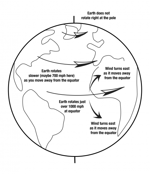
If you stand on the equator, the wind is not blowing 1000 miles per hour. This is fortunate indeed, because the “mere” 150-mile-per-hour winds occasionally reached in hurricanes can cause immense disasters. Rather, the air near the surface of the Earth on average is moving with the surface, because of the drag of mountains and trees and such on the air. This is somewhat akin to driving down the highway at 65 miles per hour with a bug stuck to your windshield. The wind at 65 miles per hour is plenty strong enough to blow a bug, but the wind very close to the windshield is very much slower than 65 miles per hour—really strong winds don’t blow close to surfaces, because of the friction of the surface, and instead the air close to the surface does almost the same thing that the surface is doing.
Now, suppose that you watch a parcel of air that rises at the equator and begins moving towards the North Pole in a convection cell. Once the air has moved a ways north, the Earth under it is no longer rotating at 1000 miles per hour, but is somewhat slower, perhaps 900 miles per hour and dropping northward toward zero at the pole. But aloft, there aren’t trees and mountains to slow the air down from the 1000 miles per hour it had at the equator. Thus, this air “gets ahead” of the Earth. The Earth rotates to the east—you see the sun rise in the east as the rotation of the Earth brings the sun into view—so, the equatorial surface air is moving east at 1000 miles per hour. As this air moves northward over slower-moving land, the wind will appear to turn to the right or east as it blows, getting ahead of the ground. Wind heading south from the equator will also move east ahead of the surface, making a left turn.
Similarly, wind moving from the pole to the equator in the returning limb of a convection cell will lag behind the rotating surface of the Earth, again seeming to turn to the right in the Northern Hemisphere (and to the left in the Southern Hemisphere). Thus, the wind cannot go directly to where it “wants” to go; instead, it turns and tends to go in circles. The circular air flow around low-pressure systems and hurricanes is unavoidable on a rotating Earth.
More-precise definitions are possible of this “Coriolis effect,” the turning of flows on a rotating Earth. The intuitive explanation given above will fail you if you think of a wind moving due-east or due-west, because those also turn. Starting from conservation of angular momentum might be better, and you can find that in any good meteorology textbook. Notice, however, that the explanation given above will get the right answer for you, in how much the wind will turn, and which way.
Notice also that Coriolis turning affects large, fast flows. The convection in the Earth is too slow to feel Coriolis much. The difference in rotation speed between opposite sides of a sink or toilet is so tiny that Coriolis turning has no significant effect on the direction that water swirls as it goes down. That is controlled by the design of the sink or toilet, and by any motion in the water at the time the drain is opened; get the water swirling in a sink and then pull the plug, and the water usually will keep swirling in the way you started it as it goes down. Dr. Alley has seen both clockwise and counterclockwise flows in Pennsylvania and Greenland, and in New Zealand and Antarctica.
More Enrichment: Why Cold Air Sinks but Valleys Are Warmer than Mountain Peaks
When air moves up, it expands, which requires that work is done in pushing away other air to make room for the expansion. The work requires energy, which comes from the heat energy in the air, so the rising air cools. Similarly, when air moves down, it contracts as the surrounding, higher-pressure air squeezes the sinking air parcel, and this squeezing is work that is done on the sinking parcel, and warms the parcel. If this is happening near the surface of the Earth, and the air is dry, the change in temperature is about 1oC per 100 m of vertical motion. This applies everywhere, at all times. So, in the 2004 movie, The Day After Tomorrow, when huge storms brought air down from above so rapidly that the air didn’t have time to warm up, that was complete hooey.
Now, imagine that a “chunk” or parcel of air, sitting somewhere, cools a little (say, by radiating energy to space as the sun goes down in the evening), and you want to know whether that air parcel will sink now. If your air parcel sinks, it must warm by about 1oC per 100 m of sinking, and it must push other air out of the way. You measure the temperature of your parcel, add 1oC for the warming from sinking 100 m, and if your air is still colder than the air it must displace 100 m below, then your parcel will sink. (Friction comes in as well—if your parcel plus 1oC would be only a tiny bit colder than the air it must displace, motion is unlikely; you need a notable difference.)
Overall, a balanced, stationary atmosphere will cool upward by about 1oC per 100 m under dry conditions, and slightly less under wet conditions (when cooling causes condensation that releases heat which offsets some of the cooling, or warming causes evaporation that uses heat which offsets some of the warming). Vertical motions will be triggered when cooling or warming creates air that is anomalously cold or warm relative to this stationary profile. So, cold air on a mountaintop won’t necessarily sink, unless that mountaintop air is anomalously cold. Perhaps on an October evening in the Appalachians, when a fog develops and holds heat in the valleys while the mountaintop radiates heat to space, then the mountaintop air will become anomalously cold and sink to the valleys.
A Rocking Review
Somewhere Over the Puddle
If you want another look at the weather system, and the difference between the Redwoods and Death Valley, the Wizard of Odd takes you Somewhere Over the Puddle in this review revue. (The Sierra tops out over 14,000 feet but in most places is lower, so don't let it bother you that the air in the GeoClip went a little higher than the air in this song--both are right, depending on just where the air goes over.)
Dr. Alley: (SINGING) Somewhere over the rainbow, raindrops fall. Sun and rain make a rainbow with your eyes in between, that's all. Sun falls straight on the equator, just skims the poles.
So tropical heating is greater. Air rises and sinks in rolls. Air lifted in these currents great expands as it feels lesser weight, brings cooling. Air cooling holds less H20, condenses to rain, clouds, or snow. That fall, no fooling.
When there's evaporation, it takes energy, That is why perspiration drying cools you or me. Equatorial evaporation stores solar heat that's released by cloud condensation. Energy is conserved, pretty neat.
This heat from Condensation slows. Cloud cooling as it upward grows while raining. But when this air comes down, it's dry and squeezing drives its fever high. And you know from your training.
Three degrees F per 1,000 feet upward, cools and rains. Five degrees F per 1,000 feet downward warms up the downwind plains. Somewhere over the rainbow, raindrops fall.
Sun and rain make a rainbow with your eyes in between, that's all. Wet redwoods, cold sierra high above Death Valley set to fry. That's why.
Wrap Up
Review the Unit 5 Introduction
You have reached the end of Unit 5! Double-check the list of requirements on the Unit 5 Introduction page and the Course Calendar to make sure you have completed all of the activities listed there.
Unit 5 Overview
Review of the main topics and ideas you encountered in Unit 5.
Weather, Weathering, and Landslides
- Sun hits equator straight-on, poles a glancing blow, so equator gets more sun.
- Sun heats Earth, drives convection in the atmosphere.
- On rotating Earth, this creates interesting winds including onshore breezes on US West Coast.
- Winds rise up Coast Ranges and the Sierra Nevada, watering redwoods and sequoias.
- Winds sink down into Death Valley, drying it.
Why Redwood Wet, Death Valley Dry?
- Warmer air can hold more moisture.
- Rising air expands and cools, sinking air is compressed and warms.
- Evaporation requires heat (so you cool as sweat evaporates), and condensation releases heat.
- Air cools 5oF for 1000 foot rise until condensation starts
- Air cools 3oF for 1000 foot rise with condensation (formation of clouds and then snow or rain).
- Air from the Pacific is wet, rises over Redwood and rains.
- Dry air comes down the other side into Death Valley.
- Air cools 3oF for 1000 foot rise going up, warms 5oF for 1000 foot fall coming down; for 15,000-foot-high mountains, air comes down 30oF warmer than it went up.
- So Death Valley is hotter than Redwood (lack of clouds to shield Death Valley warms it further).
- Air going from Redwood to Death Valley is heated when condensation releases the energy originally used in evaporating the water that rains out on Redwood.
Rocks Not Forever
- Weathering=physical changes that make small rock pieces from big, and chemical changes that make new minerals.
- Physical from crystal growth in cracks (especially ice), etc.
- Common rock granite has quartz= silica (silicon+oxygen), feldspar=aluminum+silica+(calcium or sodium or potassium), dark mineral=iron+magnesium+silica; chemical weathering.
- Quartz stays as quartz sand (little change).
- Feldspar makes clay; calcium and sodium wash away.
- Dark mineral makes rust; magnesium and silica wash away.
- Rust+sand+clay+worm poop=soil.
- Calcium and silica go to make shells in the ocean.
- Magnesium reacts with hot sea-floor rocks
- Sodium makes the ocean salty.
- Soil eventually washed to ocean.
- Subduction takes seawater, sediment, shells, and soils down to melt, rise, and solidify as granite in a nearly-balanced cycle.
Mass Movement
- Mass movement is the downhill transport of soil, rock without rivers.
- Mass movement ranges from huge, destructive landslides to barely measurable soil creep.
- Rivers usually pick up material from mass movement and take it on.
- Usually get a balance between soil production by weathering and soil removal, although humans are upsetting the balance in many places.
- Can often figure out where mass movement is potentially destructive, and stabilize slopes or stay out of the way.
Reminder - Exercise #2 is due and Exercise #3 opens this week. See Course Calendar for specific dates and times.
Supplemental Materials
Following are some supplementary materials for Unit 5. While you are not required to review these, you may find them interesting and possibly even helpful in preparing for the quiz!
- Website: Grand Teton National Park [23]
Comments or Questions?
Please feel free to send an email to ALL of the teachers and TA's through Canvas conversations with any questions. Failure to email ALL teachers and TA's may result in a delayed or missed response. See "How to send email in GEOSC 10 [24]" for instructions