Unit 8: Coasts and Sea-level Changes
Welcome to Unit 8
Coasts & Sea-level Changes (Cape Cod & Acadia)
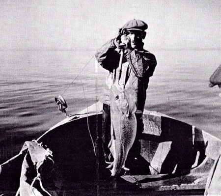
The cod has been an extremely valuable resource for several centuries in Massachusetts. Its extensive use as a food dates back to the earliest period of European settlement in coastal New England. In colonial times, it was deemed so important that in 1693 the General Court of the Massachusetts Bay Colony ordered that farmers could no longer use cod as fertilizer. This action was one of the first recorded attempts at natural resource conservation and management on this continent.
Although one of the earliest fisheries resources to be broadly utilized after European settlement in New England, cod populations along the US coast proved to be very resilient. Cod apparently withstood more than 3 centuries of harvest without displaying major, long-term regulations in abundance. However, mid-twentieth century advances in fishing technology and the introduction into the northwest Atlantic of distant-water foreign fishing fleets during the late 1950's led to a period of reduced abundance and major annual fluctuations in population size. During the mid-1980s commercial vessels captured mostly 3 to 5 year old fish, indicating that few larger, older individuals remain along the North American coast.
—From the Massachusetts Division of Marine Fisheries
Will Cape Cod be there in the future? Looking out a few millennia, the answer is probably "no." Beaches, like rivers, are interplay of water and sediment. Sand is supplied, and sand is lost. Interrupt this process, and the coast must change. And in the distant future, Cape Cod is likely to be the new Georges Bank, an underwater place that could be home to great masses of fish, if we leave enough fish to get along and get it on.
What to do for Unit 8?
You will have one week to complete Unit 8. See the course calendar for specific due dates.
As you work your way through the online materials for Unit 8, you will encounter a video lecture, several vTrips, some animated diagrams (called GeoMations and GeoClips), additional reading assignments, a practice quiz, a "RockOn" quiz, and a "StudentsSpeak" Survey. The chart below provides an overview of the requirements for this unit.
| REQUIREMENTS | SUBMITTED FOR GRADING? |
|---|---|
| Read/view all of the Instructional Materials | No, but you will be tested on all of the material found in the Unit 8 Instructional Materials. |
| Submit Exercise #4: Which Way is Up? | Yes, this is the fourth of 6 Exercises and is worth 5% of your total grade. Please see the course calendar for specific open and close dates and times. |
| Begin Exercise #5: Puzzling Out Relative Time | Yes, this is the fifth of 6 Exercises and is worth 5% of your total grade. |
| Take the Unit 8 "RockOn" quiz | Yes, this is the eighth of 12 end-of-unit RockOn quizzes and is worth 4.5% of your total grade. |
| Complete the "StudentsSpeak #9" survey | Yes, this is the ninth of 12 weekly surveys and is worth 1% of your total grade. |
Questions?
Please feel free to email "All Teachers" and "All Teaching Assistants" through Canvas conversations with any questions.
Keep Reading!
Students who register for this Penn State course gain access to assignment and instructor feedback, and earn academic credit. Information about registering for this course is available from the Office of the University Registrar [1].
Main Topics, Unit 8
Overview of the main topics you will encounter in Unit 8.
Cape Cod girls don't have any combs
Look away, look away
They comb their hair with codfish bones
We're bound for Australia.
Cape Cod boys don't have any sleds
Look away, look away,
They slide down dunes on codfish heads
We're bound for Australia.
Cape Cod brides don't have any veils
Look away, look away
They shield their eyes with codfish tails
We're bound for Australia.
—Traditional sea shanty
Getting the Most from the Coast: Cape Cod, Acadia, and Friends
- There are many "types" of coasts (beaches, reefs, mud flats, cliffs, deltas, etc.; we’ll especially focus on beaches).
- Waves move LOTS of sand, mostly in, out, in, out…, which sorts by size to give sandy beaches.
- Waves move a little extra sand out during winter storms (breaking waves come in through air without sand, go out along surface with sand).
- And waves move a little extra sand in during summers (a wave surges up beach a bit faster than the water flows back out, and thus moves a bit more sand in than out),
The Coast Is Friendly—the Ocean Waves
- Waves go slower in shallower water.
- The first part of a wave slows as it nears the coast and waits for the rest of the wave to catch up, so the wave "piles up" to break, and turns to come almost straight in.
- But "almost" is not "completely" straight in, and this slight angle drives longshore drift of sand and water.
- Eventually, some sand is lost to deep water below the reach of waves.
- A beach thus needs sediment supply to balance this loss.
The Coast Is Friendly—Buoy Meets Gull
- New beach sand is supplied by longshore drift from river-fed deltas,
- or by erosion of the coast behind the beach.
- We can lose the longshore drift from river-fed deltas, and thus promote erosion of land behind the beach with houses, roads, and such, by
- dams on rivers (Elwha River dams in Olympic caused beach loss).
- “dams” along coast (jetties or groins that stick out, block drift to trap sand, and let clean water pass to erode beyond),
- past sea-level rise, which flooded river valleys so river sediment fills bays and doesn’t reach outer beaches (e.g., Chesapeake),
- past deposition (especially by glaciers) forming coastal land (e.g., Cape Cod) where there are no big rivers to supply sand.
But many coastal residents are crabby
- Most U.S. coasts are retreating (about 75%)
- —from past sea-level rise and glaciation, dams and coastal modifications (see previous point, "The Coast Is Friendly—Buoy Meets Gull")
- —from sea-level rise now (from warming expanding water and melting ice, plus groundwater mining, with worries about future of huge ice sheets)
- —from pumping of groundwater, oil and gas allowing compaction and sinking
- Many regions pushed down by ice-age ice are still rising, while those bulged up before the ice-age ice are sinking; mountain-building also can matter.
Textbook 8.1: Cape Cod
Coasts and Cape Cod
The author, Dr. Alley, is a lucky fellow. Through a fortuitous sequence of events, which involved marrying the right woman who had the right grandfather who was related to some people who have roots in the right place and worked to preserve those roots, our family has been able to occupy a room in the smallest of three houses in a “compound” in Eastham on Cape Cod for a couple of weeks during many summers. The land now belongs to the National Park Service as part of the Cape Cod National Seashore, but the houses were “grandfathered” and remain in the extended family. The bicycle trail to the Coast Guard Beach crosses the driveway, the Salt Pond Visitor Center is just around the corner, and the boat houses face Salt Pond Creek that opens on the Nauset Marsh.
Cape Cod is a glacial moraine. The part that attaches to the mainland marks the end of a lobe of the Canadian ice sheet. The “forearm” where the Cape points north is an interlobate moraine—while one glacier lobe filled Cape Cod Bay between the Cape and Boston, a second lobe lay farther east in what is now the Atlantic Ocean, and built a moraine that is now the fertile fishing grounds of the Grand Banks. (You will see this when you reach the geologic map later in this section.) The forearm of the Cape was deposited mostly by meltwater rivers flowing off these two ice lobes into the narrow space between them (more till is found along the “upper” arm of the Cape where it first projects out from the “mainland”).
This forearm part of the Cape thus is an outwash plain, and most of the numerous freshwater ponds of the Cape began their lives as ice blocks buried in outwash gravels. Melting of the ice later allowed collapse of the gravels on top to form these kettle ponds. Soon after it formed, the Cape had more ponds than we see today, but many have been filled with logs, sticks, leaves, peat, and other organic material. The logs and other materials in these former kettle ponds can often be seen weathering out of the bluffs along the Atlantic beach, including along the Coast Guard Beach that is so easily reached from the Salt Pond Visitor Center of the National Seashore. Radiocarbon dates on such deposits show that the ice was retreating from the Cape Cod region by roughly 15,000 years ago.
The sandy soils of the Cape, and its numerous kettle ponds, are home to cranberries, blueberries, and wild orchids. Beach plums produce their small but sweet fruit late each summer, and blackberries and dewberries vine across old dunes. Deer and grouse still inhabit the uplands, and turkey are multiplying rapidly as oaks spread across regions that were logged by humans but are being allowed to regrow.
Much of the interest at the Cape focuses on the sea. Nauset Marsh, for example, is miles long and a good chunk of a mile wide. The marsh is protected from the open ocean by the “outer beach,” a long sand bar that is split by one inlet or occasionally more inlets (depending on what year you visit). Behind the outer beach, the marsh is a tidewater environment, filled and then largely emptied by the flow through the inlet. Deep channels are home to crabs, scallops, starfish and striped bass. Between the channels, great flats of marsh grass flood during high tides and dry as the tide falls. Legions of herons and egrets stride the grass, and myriad shorebirds roam the beaches and mud flats. Osprey survey the marsh from high nests on perches constructed by the Park Service.
One year, a hurricane to the south had spun unusually warm waters and great swells to the Cape, and the marsh filled with ctenophores. Also called comb jellies, and looking something like jellyfish, these creatures appear opalescent in the sun because the light is broken on the cilia or hairs that the creatures beat to move themselves about. At night, this particular type (Leidy’s comb jelly) is bioluminescent. Imagine, if you can, kayaking into the marsh after dark, with golf-ball-sized fireflies of the ocean glowing and swirling with every wave. Another year, phosphorescent dinoflagellates were blown into the marsh, and the glow was everywhere rather than just in the ctenophores, with every drip from the kayak paddle lighting up, and fiery baitfish skittering across the surface, pursued by the glowing bulk of predatory stripers. Indeed, a wonderful place.
The Cape is changing rapidly, however. The large Nauset Marsh, between Orleans and Eastham, has been narrowing as the outer beach moves steadily into the marsh. Two of the Cape’s lighthouses were moved during the summer of 1996, barely in time to avoid collapsing over the bluffs into the sea as the bluffs have been eroded away.
At the ends of the Cape, to the north and south, new land is being formed as sand is deposited (yellow on the map below). But, more than twice as much land is lost each year as is formed, and the Cape is slowly but surely disappearing. With the next ice age to rebuild the Cape still far in the future, the Cape appears destined to become islands and then an undersea bank over the next few thousand years. The long-term retreat rate of the Outer Beach in Eastham has been about 3 feet per year over more than a century, with fluctuations but perhaps with a little recent acceleration.
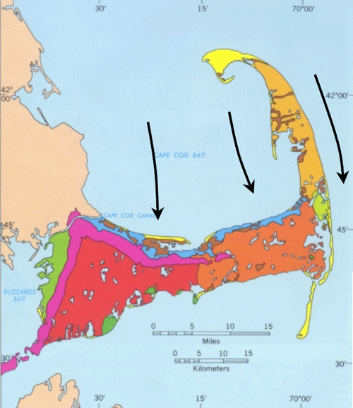
This map from the USGS Woods Hole group shows the geology of Cape Cod. Magenta indicates glacial moraines containing till, and green shows other deposits formed in contact with ice. Oranges and red are outwash plains. Blue marks deposits from a lake that formed when the ice began melting back from the Cape but still plugged Cape Cod Bay and kept the ocean out. Brown shows marsh deposits, and yellow shows new sand deposits. We added the black arrows to show where the ice flowed in the past.
Waves and Coasts
There are many types of coasts. North of the Cape at Acadia National Park, Maine, strong igneous and metamorphic rocks make sea cliffs. South, in the Virgin Islands National Park, are coral reefs. Built from the skeletons of millions of tiny animals, the reefs rise from the sea bottom and flourish in shallow, clear, sunlit, oxygenated waters far from sediment that would bury and choke them. Around into Louisiana, you remember the Delta National Wildlife Refuge, and the miles of waterfowl-filled wetlands on mud delivered by the Mississippi River. At Cape Cod, we find barrier beaches or barrier islands offshore of marshes, or we find sandy beaches with the bulk of the Cape just behind.
The type of coast depends on the supply of sediment to it, the wave energy, the tidal range, the type of rocks, and many other factors. Here, we will concentrate on the Cape Cod sandy beaches.
Watch a wave on the Cape, or any other sandy beach, and you will see that the wave moves a lot of sand. Dig a hole just above the water level during a rising tide, and within a few minutes the hole will be filled with wave-carried sand. Go to the beach during a big storm and you will see immense amounts of sand moved. Hundred-foot-high bluffs may be eroded back several feet, or layers of sand many feet thick may be added to the beach or eroded from it in hours. A movie at the Salt Pond Visitors Center includes a series of photos taken of one section of beach before and after a string of storms one winter. The summer beach is an unbroken expanse of sand, but boulders many feet across are buried in it, and were completely covered and uncovered several times during that one winter as the sand was moved on and off the beach.
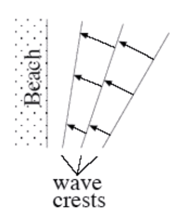
The energy for all of this comes from the wind driving waves, and to a lesser extent from the tides. Most of the sand transport is simply onshore and offshore with each wave—the sand is carried in as a wave comes in, and out as the wave goes out. Most transport is to and from the beach, rather than along the beach, because most waves turn so that their crests are almost parallel to the beach, and their water motion is almost directly towards and away from the beach. The turning happens because waves go slower in shallower water. If a wave approaches a beach at an angle, the first part to near the beach will slow down, allowing the rest of the wave still in deep water to nearly catch up, as shown in the diagram to the right.
Every wave moves sand up and down the beach. On even rather quiet days, if you sit down on a Cape Cod beach in shallow water, you soon will find that sand is piling in places around you, and being eroded in other places, and that you have sand in your swim suit, and possibly even in your hair. This in-and-out movement of the sand with every wave dominates the sand transport, allows for very efficient sorting of the sand by size, and serves to knock the sharp edges off sand grains, sea shells, old soda bottles, and other material on the beach.
Look out to sea during a winter storm, and you’ll see high-energy breakers coming at you. The white caps of the waves rise high, curl over and crash down, so that some of the water arrives on the beach after coming in through the air rather than washing along the sand. But the water then rushes back toward the ocean along the sand, carrying some sand seaward. There thus often is a little net movement of sand from the beach into slightly deeper water during storms, which are more common during winter than during summer. This transport may remove enough sand to lower the beach many feet or tens of feet during the winter, exposing buried boulders. The waves of summer are on average lower in energy, and don’t break and travel through the air as much (occasional hurricanes change this story, but most of the time the story is fairly accurate). The surge of summer waves up the beach is slightly faster than the return flow down the beach, and may carry a tiny bit more sand up than back; the net effect is to bring sand from just offshore back to the beach, burying any beach boulders that were exposed during the winter.
But, the incoming waves do not turn quite enough to come straight in, as shown in the diagram—they still have some angle. If you ride the waves in, swim out, ride in, swim out, ride in... after a while you will find you have drifted down the beach away from the lifeguard—even though you were mostly going toward the beach and back out to sea, the waves also were pushing you sideways. In such a situation, we say that you are experiencing longshore drift—you, and the water, and sand, are moving along the shore. Eventually, when the water and sand reach the end of the Cape (at the Provincelands to the north, or Monomoy to the south), some of the sand builds a spit or extension of land, but some of the sand is dumped off into deeper water beyond the reach of waves. This sand is then lost from the Cape, and the Cape has gotten a little smaller. Most references say that the great beach facing the Atlantic is retreating at about 3 feet (1 m) per year, although it may have been a little faster recently, and the panicked light-house rescues were required because retreat for a few years was much faster. We’ll look at these issues, and what might be done, after visiting Acadia in the next chapter.
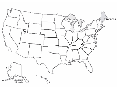
Textbook 8.2: Acadia
Acadia and Sea-Level Rise
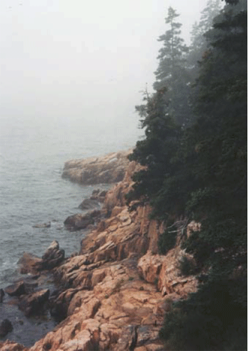
The subduction and collision with Europe during the closing of the proto-Atlantic made great granite bodies draped in metamorphosed sediments, and we find these exposed along the Maine coast. Much later, the glaciers scoured those rocks clean, leaving the bald mountain tops of what is now Acadia National Park, staring out at the storm-tossed north Atlantic across Somes Sound, the only fjord on the east coast of the U.S.
The Wabanaki tribe of Native Americans probably reversed the modern tourist pattern, summering inland and then moving to the relatively more moderate coast of Acadia in the winter. Nasty winter storms do run up the coast, but the temperatures plunge far lower inland than they do on the coast. Thick piles of discarded shells of nutritious sea creatures dating back 6000 years attest to the importance of the sea to these early people.
On September 5, 1604, the French explorer Samuel de Champlain landed on Acadia’s island. Impressed by the bare, rocky, deserted appearance of the glacially scoured granite mountain peaks of the island, he named it Isles de Monts Desert.
French influence was important until the end of the French and Indian War, after which English and then U.S. activity came to dominate. In the mid-1800s, Mount Desert Island attracted the art world, and was featured in paintings by Frederic Church, Thomas Cole and others of the Hudson River School (for example, have a look at Twilight: Mount Desert Island, Maine by Frederic Edwin Church [2]. The artists, in turn, attracted the “rusticators,” tourists who gradually were replaced by much wealthier tourists who built summer “cottages”—the Rockefellers, Fords, Vanderbilts, Carnegies, etc. These wealthy patrons in turn invested resources and political capital in preserving most of the island as a national park.
Today, over 4 million visitors per year flock to Mount Desert Island, with most of them getting out of the gift shops and into the national park. The visitors enjoy the history, the beauty, the rather chilly ocean waters (based on personal observation by the author, even on hot summer days, there is more sitting by the sea than swimming in it!), the outstanding network of paths for bicycling, superb kayaking on lakes and sea, and much more.
Changing Coasts and Sea Levels
Change is the only constant on coasts. The Sea Grant Program at the Woods Hole Oceanographic Institution, on Cape Cod, reported that about 75% of the U.S. coastline is eroding, with only about 25% stable or advancing. For Massachusetts, 68% of the coastline is listed as eroding, 30% advancing, and a mere 2% stable.
Up in Maine, the rocky parts of Mt. Desert Island are among the few places that would be classified as “stable,” although very slow erosion is occurring as the sea pounds the granite headlands. But if you look further back in time, the size of the changes becomes evident. Glacial ice overran the highest peaks in the park during the ice age. Sea level was lowered 300-400 feet (100 m or a bit more) at that time to supply the water that grew the ice sheets, but the land of Mt. Desert Island was pushed down 600-700 feet (roughly 200 m) or even more by the weight of the ice.
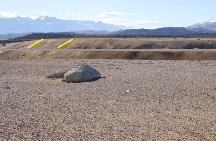
Ice farther south began melting before the ice on Maine, so the sea began rising, but then loss of ice on Maine caused its rocks, including Mt. Desert Island, to begin rising faster than the sea. The rising of the pushed-down rocks is slow, and in fact is still going on today. Thus, as the ice retreated, the already much-raised sea first flooded in across broad regions of Maine and adjacent parts of the east coast. Beaches and sea caves formed, and deltas were deposited. Then, these coastal features were raised out of the ocean as the land rebounded. Such coastal features can be found today in Acadia to almost 300 feet (almost 100 m) above the modern sea level, and similar features occur all along coastal Maine. We include a picture of a similar delta from Greenland; the features in Maine are covered with trees and houses and roads and such, and although the features are quite easily identified by experienced geologists, the features are not as clear as those in Greenland to the beginning geologist.
Regions that were slightly beyond the reach of the ice-age glaciers were pushed up in a forebulge, when the hot, soft, deep rocks pushed out from beneath the sinking ice sheets bulged up the land just before the ice. In those forebulge regions, the land now is sinking, as the deep, hot rocks flow back to their starting point; where forebulge sinking has combined with rising sea level as the ice melted, the total sea level rise has been especially large. Far from the ice sheets, sea-level rise has been about what you would expect based on the amount of water returned to the ocean by the melting ice sheets (although the entire surface of the Earth was warped by shifting water from the oceans to the ice sheets and back, so the changes are all a bit more complicated than you might expect, just as a wine glass balanced anywhere on a cheap water bed will tip over if you sit anywhere on the bed).
By now, you may be getting the idea that what happens to a particular coast is fairly complex. If mountain-building is pushing the coast up, it rises; if mountain-building is pushing the coast down, it sinks. Where plates meet, when the edges are locked and building toward an earthquake, the motion may drag one side down and push the other side up; the earthquake that follows will suddenly reverse the offset—in the great Tohoku earthquake of Japan in 2011, parts of the Japanese coast moved as much as 8 feet toward North America, and offshore the largest motions of the sea floor were more than 150 feet horizontally and more than 20 feet vertically. Where cities are built on deltas, as at New Orleans, the compaction of the mud causes sinking. Much additional sinking is caused by pumping water or oil or gas out of the ground; as the fluids are removed, the ground compacts. This is happening a little on Cape Cod, and is quite dramatic in some places. Groundwater pumping may have contributed to problems at New Orleans, in Venice, and elsewhere. (Reinjection of fluids can partially offset this problem, and is being used in some places.)
Additional complexity comes from the issues of sediment supply. Beaches inevitably lose a little sediment to deep water, somewhat like losing socks behind a clothes dryer, because it is easy to drop something that falls way down there, and hard to get it back. Waves affect sediment below the surface, but only down to a depth that equals roughly half the distance between a wave’s crest and the next one. If sediment happens to slide or bounce deeper than the depth reached by the deepest-reaching waves, then that sediment cannot be brought back easily. (The sediment can go into a subduction zone, be taken down and scraped off, or else melted and erupted and loosened by weathering and landslided and transported in a river and then in longshore drift to the beach, but that takes a long time.) And, longshore drift moves a lot of sediment, but eventually the sediment often encounters an undersea canyon and drains down to deeper water below the reach of waves.
Thus, a “happy” beach requires a supply of sediment to balance the loss to deep water. Normally, that supply comes from the material delivered to deltas by rivers, and carried by longshore drift. But if there is not enough sediment coming in this way, the beach will narrow as it loses sediment to the deep ocean, and the waves will reach across the sand to erode the material behind, gaining sediment in this way.
In those cases when longshore drift does not supply enough sand to make a beach, and the waves are battering on the coast, if the rocks are really hard, like the granite of Acadia, then there won’t be a beach at all, with the tiny bit of material eroded from the granite quickly dumped into deep water. (There are a few small “pocket” beaches at Acadia in protected places, but most of the coast doesn’t have beaches, with granite sticking right out into the waves.) If the coast is sand and gravel left by the glaciers, as seen at Cape Cod, the waves cut the coast back and supply that material to the beaches.
In some places, dams on rivers have greatly reduced delivery of sediment, so the coasts are eroding. You may recall that the dams on the Elwha River, draining Olympic National Park, caused loss of beaches along the coast. At Cape Cod, there really aren’t any rivers to dam. The glaciers made a big pile of sediment in a place where rivers are not supplying much sediment to deltas, and so the Cape eventually will be lost to deep water.
Rising Sea Level and the Future
So coasts change for many different reasons, and in many different ways. But, recently, most of the U.S. (and world) coasts have been retreating because sea level is rising, and that rise is accelerating.
The rate of rise has been about 2 mm/year (just under an inch per decade) over the last century, but seems to have sped up to about 3 mm/year (a bit over an inch per decade) recently. That isn’t much if you’re at the top of a cliff in Acadia, but if you are on a sandy beach that slopes very gradually, the inch of sea-level rise may cause many feet, or even a few tens of feet, of coastal retreat. That in turn means that a whole lot of houses and property can be lost in a single lifetime.
The ongoing sea-level rise is being caused primarily by the global average warming of the last century, which is being driven primarily by human activities (we’ll return to this later, but we have high scientific confidence that it is correct). Most of the world’s small glaciers have been melting this century, returning water to the oceans. Also, as the ocean itself warms, the water expands and takes up more room.
Two other possible causes of sea-level change are humans "mining" groundwater, and melting or faster flow of the polar ice sheets. We build dams on rivers, and the water that fills the reservoirs is taken out of the ocean and stored on land, causing sea-level fall. But, we “mine” groundwater by pumping it out of the ground faster than nature puts it back, in places such as Phoenix, Arizona where green yards and golf courses and fountains seem to “need” LOTS of water, and that water eventually reaches the ocean to raise sea level. Today, groundwater pumping is probably more important than dam building, contributing a little to sea-level rise.
The polar ice sheets contain a huge amount of water—if they melted, they would raise sea level nearly 250 feet (roughly 70-80 m). Philadelphia and the other great port cities of the world would become undersea hazards to shipping but really great places for fish to hide out, and the southern coast of Florida would be somewhere up in Georgia. We do not expect such a fate within at least the next few human lifetimes, but we cannot rule out the possibility that a dynamic collapse of the West Antarctic ice sheet could raise sea level 10-20 feet (3-6 m) in a human lifetime or two, and if we don’t change our behavior over centuries, Greenland and its 24 feet of sea level is looking shaky. Drs. Anandakrishnan and Alley spend a lot of their research trying to reduce our uncertainty about the future of the great ice sheets, a fascinating and important topic.
The near-certainty of continuing sea-level rise has some policy implications. For example, disaster aid following hurricanes that allows people to rebuild in coastal regions will simply create the need for more disaster aid in the future. Many people believe that those who wish to build on the coasts should be required to carry insurance to cover their coming losses. Similar arguments apply to those who wish to build on earthquake faults, landslide deposits, and floodplains. Why should those living in relatively safe but less-scenic places pay for others to live in dangerous but beautiful places?
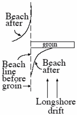
Because people love the coasts so much, and wish to live near them, all sorts of engineering solutions have been tried. One is to build “dams” (usually called “groins” if they are small, or “jetties” if larger) that stick out into the water and block the longshore transport of sand (see figure to the left). By making the coast rougher, and slowing waves, the plan is to trap sediment along the coast the way a dam traps sediment along a river. This plan sometimes works. However, recall that in a sand-bedded river, sediment is trapped upstream but eroded downstream. The same often happens along a coast; sediment is trapped “upstream” of the groin (on the side from which the longshore drift comes), but sediment is eroded on the “downstream” side (the side to which the longshore drift goes), where the sand-free waves attack the beach to pick up more sand. Saving someone’s beach while destroying the beach of a neighbor is a good way to generate lawsuits. People also spend millions of dollars to go out to sea, find sand that has fallen off into deep water, and bring the sand back to the beach. This sand usually lasts a single year or a very few years before being washed back to deep water, but in especially popular tourist destinations, the investment may pay off.
Geologists often take a “natural” view of the coasts—we should figure out where the coast wants to go, and build there rather than trying to stop the coast. But many people just don’t like that, and a lot of construction is likely to occur—and be destroyed—over the years.
Virtual Field Trips
Join Dr. Alley and his team as they take you on "virtual tours" of National Parks and other locations that illustrate some of the key ideas and concepts being covered in Unit 8.
TECH NOTE
Click on the first thumbnail below to begin the slideshow. To proceed to the next image, move the mouse over the picture until the "next" and "previous" buttons appear ON the image or simply use the arrow keys.
Virtual Field Trip #1: Cape Cod National Seashore
Source: NASA. [3] All other pictures in this slide show are by R. Alley, C. Alley, J. Alley, or K. Alley.
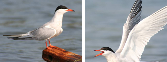
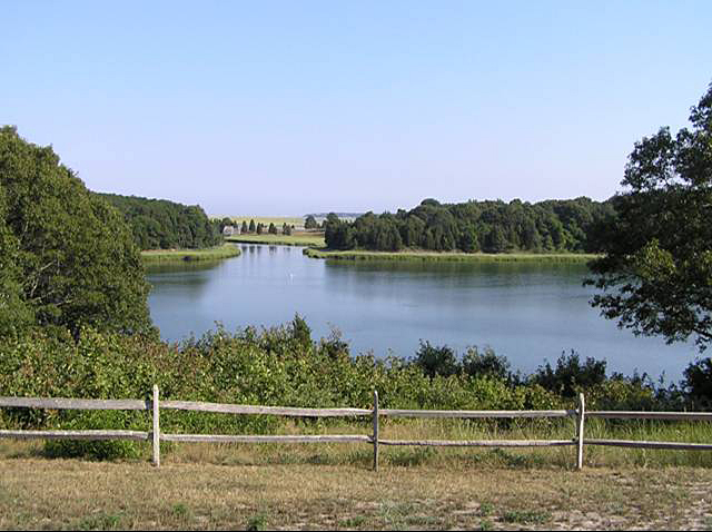
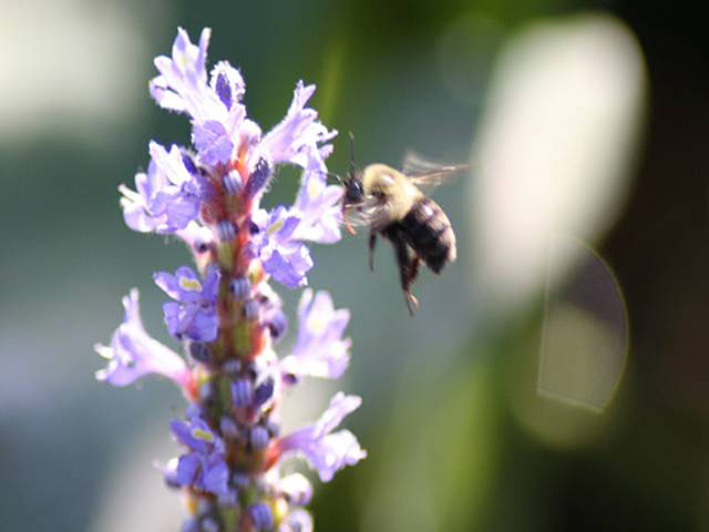
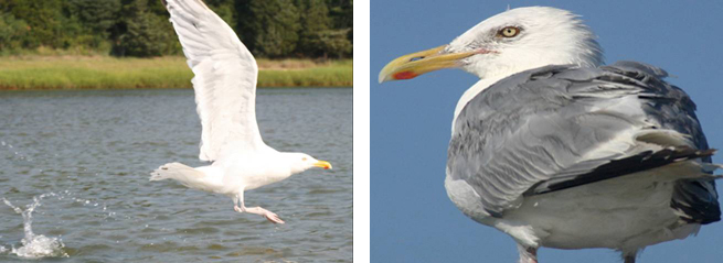
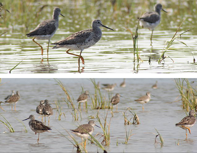
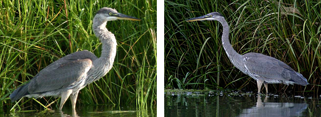
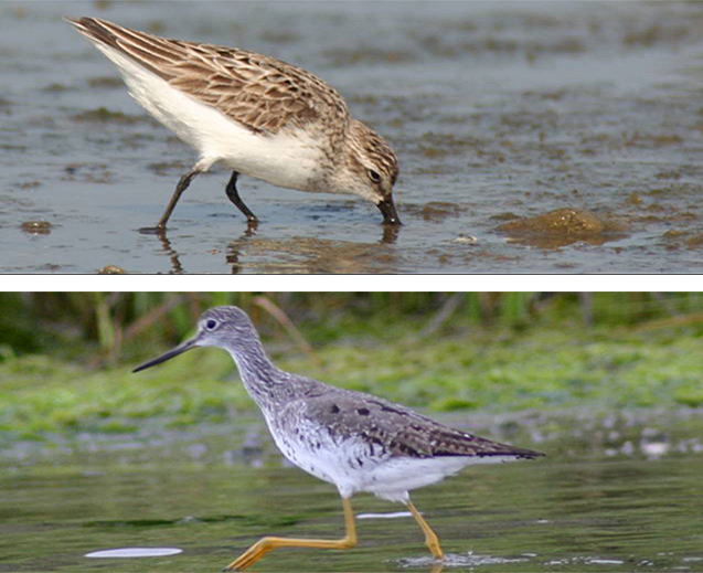
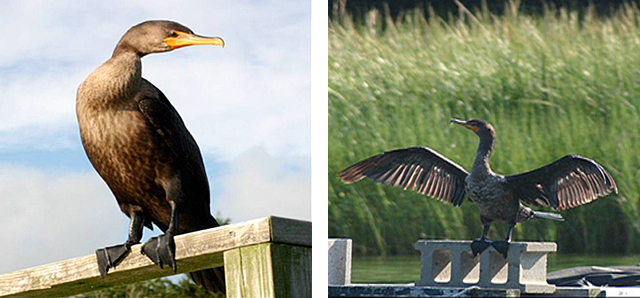
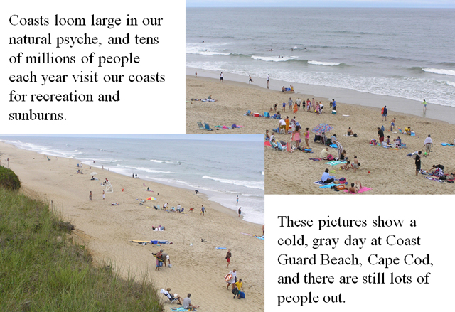
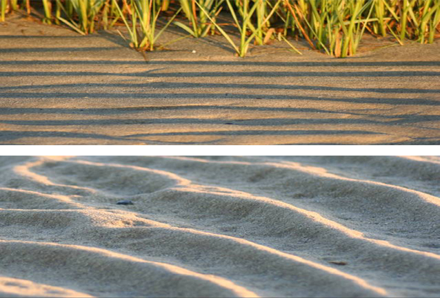
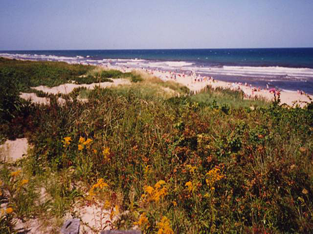
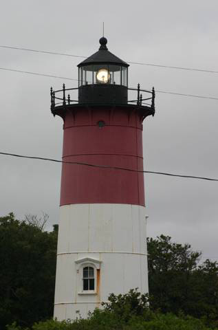
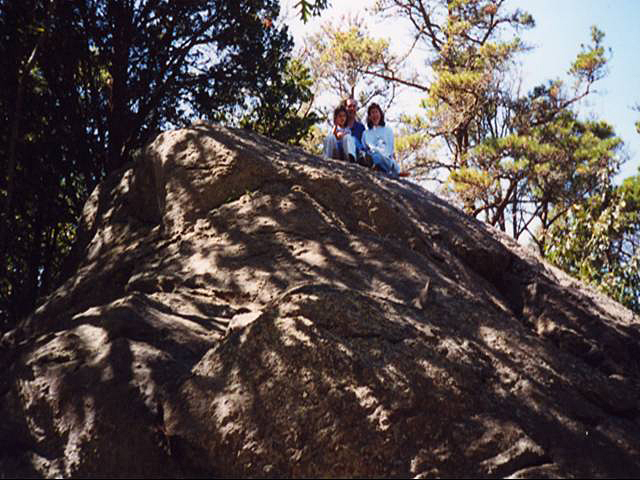
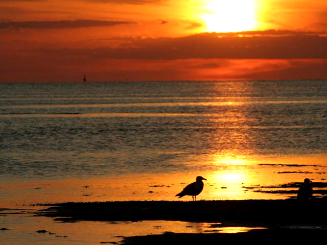
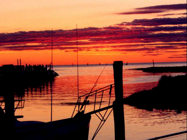
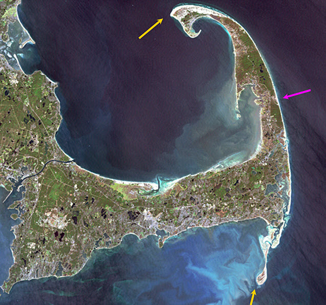
Image 1: Landsat image of Cape Cod. One arrow points to the eroding outer beach on the right. Two more arrows point to areas of sand build out to the south and north. NASA [3] Sept. 18, 1999 Landsat image of Cape Cod. The Outer Beach (magenta arrow) along the right-hand side of the Cape is eroding back at a few feet per year. Some of the sand is building out to the south and north (yellow arrows), but some of the sand is being lost to deeper water, so the Cape is shrinking. All pictures in this slide show, except this one, by R. Alley, C. Alley, J. Alley or K. Alley.
Image 2: On the left, a tern perched on a piece of wood. On the right, a tern in flight. One good tern… deserves another.
Image 3: The Nauset Marsh, Cape Cod National Seashore. Water surrounded by green trees, under pale blue sky. Split rail fence in foreground. The great Nauset Marsh, viewed from the back porch of the Salt Pond Visitor Center, Cape Cod National Seashore.
Image 4: Close-up of a bumblebee on a pickerelweed. Bumblebee visiting pickerelweed, which grows in the shallows at the edge of Great Pond, Eastham, Cape Cod. By building a lake-studded outwash plain into the ocean, the glaciers left a rich mix of aquatic habitats.
Image 5: On the left, a herring gull landing in the water. On the right, close-up of herring gull perched. Gulls, such as these herring gulls, are widespread and successful generalists, equally at home along fresh and salt waters, as well as cleaning up messes left by humans.
Image 6: On top, a close-up of three yellowlegs in Nauset Marsh. Below, twelve or more yellowlegs in the marsh. Yellowlegs are well-named, and common in Nauset Marsh.
Image 7: Side-by-side close-up images of a great blue heron standing in the marsh in front of tall water grass. Great blue herons, Nauset Marsh. A fish that doesn’t watch out may realize too late that he blue it.
Image 8: On top, a close-up of a sandpiper on the beach with his beak in the sand. Below, a close-up of a yellowleg standing in the water. Salt marshes are highly productive, and support a diversity of life… including sandpipers (top) and yellowlegs (bottom). Nauset Marsh, Cape Cod.
Image 9: On the left, a close-up of a cormorant perched. On the right, a close-up of a cormorant on a cinder block with his wings spread. Cormorants were not present on the Cape a few decades ago, but now are commonly seen fishing or drying their wings.
Image 10: Large number of people on the beach at Coast Guard Beach, Cape Cod. slide 10 Coasts loom large in our natural psyche, and tens of millions of people each year visit our coasts for recreation and sunburns. These pictures show a cold, gray day at Coast Guard Beach, Cape Cod, and there are still lots of people out.
Image 11: On top, rippled sand, with beach grass in the background. Below, a close-up of rippled sand. Waves and tidal currents move immense amounts of sand, leaving beautiful ripples, as shown in these closeups from First Encounter Beach.
Image 12: Cape Cod sand dune with a thin layer of hardy vegetation. Ocean in background spotted with beach goers. Cape Cod’s beaches may be backed by rapidly eroding bluffs, by sand dunes covered with a thin layer of hardy vegetation that can be damaged easily by human activities (as shown here), or by salt marshes.
Image 13: Nauset Light, lighthouse on Cape Cod. Nauset Light. The light was moved in 1996, just before the rapid erosion of the bluffs along this part of the coastline dropped this historical building into the waves. Everyone with a long memory of the Cape has stories of things that have been lost to the encroaching sea.
Image 14: Family of three sitting atop Great Rock. Great Rock, the Cape’s largest glacial erratic (big rock carried by the glacier) attests to the ability of ice to move pieces of many different sizes. The rock extends below the picture, and then about as far into the ground as above.
Image 15: Bright orange sunset at First Encounter Beach. Herring gulls in the foreground. Herring gulls at sunset, First Encounter Beach, Cape Cod.
Image 16: Sunset at Rock Harbor, Cape Cod. Boats docked on left. Sunset, Rock Harbor, Cape Cod. It isn’t very geological, but it’s pretty.
Virtual Field Trip #2: Acadia National Park
.jpg)
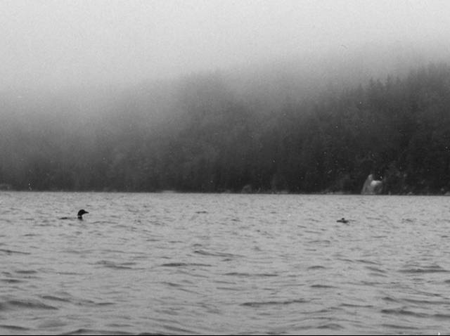
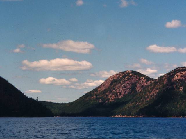
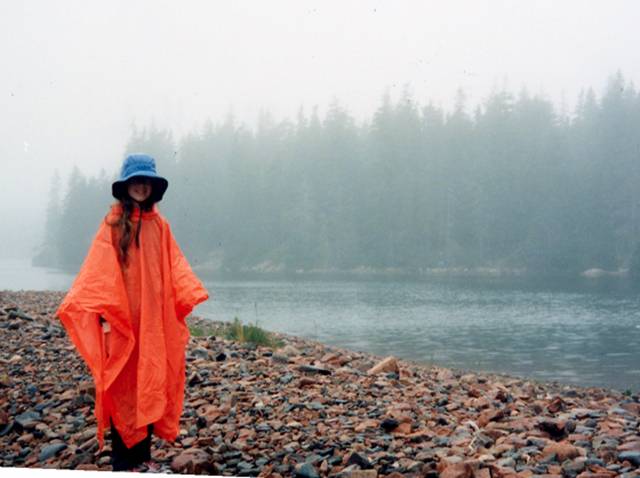
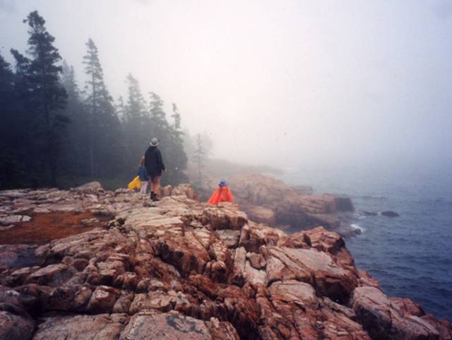
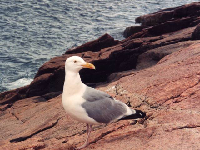
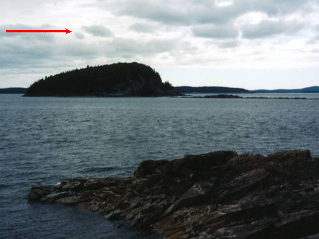
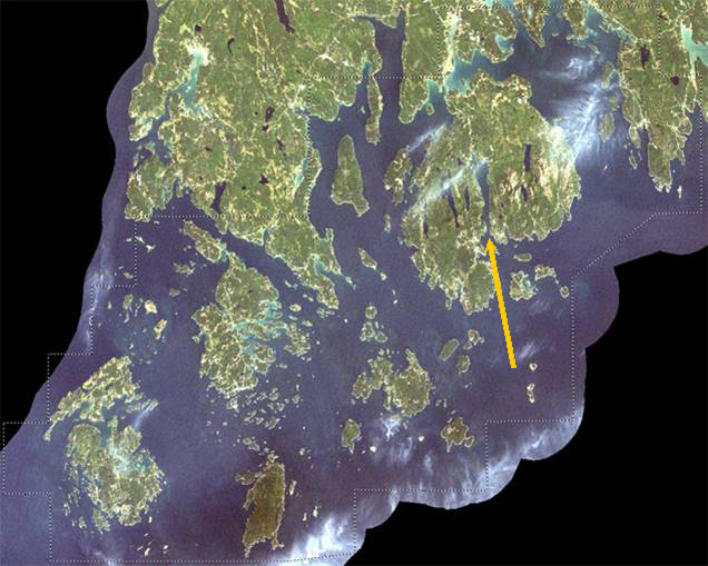
Image 1: Satellite Image of Rhode Island Acadia and surroundings. Arrow points to the fjord of Somes Sound in Mount Desert Island. Credit: NASA [3] GSFC & Y.Q. Wang at the Laboratory for Terrestrial Remote Sensing, Univ. Rhode Island Acadia and surroundings. The yellow arrow points toward the fjord of Somes Sound in Mount Desert Island. The dotted line marks an area of interest for NASA and the National Park Service, and regions beyond have been blacked out. All pictures except this by C. or R. Alley
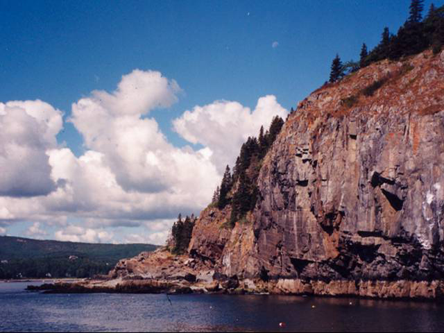
Image 2: Lobster pots floating in water in front of large cliffs. Blue skies with puffy white clouds. The old metamorphic rocks (shown here) and granites of Acadia make dramatic cliffs. Floats for a few lobster pots are visible in the water.
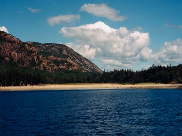
Image 3: Beach at Acadia with water in foreground, mountains and cloudy skies in background. This beach at Acadia is one of the few in the area. Most of the sand is calcium carbonate--ground-up shell--because the Gulf of Maine is so amazingly productive of shells to be ground up by waves. The beach is far at the end of an inlet; the rest of the coast is dominated by bare rock.
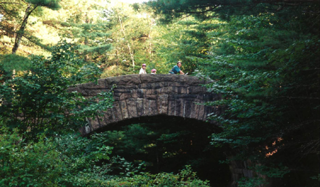
Image 4: Family on bicycles crossing an arched stone bridge, surrounded by forest. The Rockefeller-constructed carriage roads and their graceful bridges are well-loved at Acadia, which offers wonderful opportunities for bicycling. Dr. Alley and daughters Janet (left) and Karen for scale.
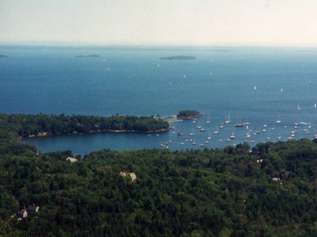
Image 5: Ocean with inlet and forested land in foreground, small islands in the distance. Sailboats anchored in the inlet and sailing in the distance. View of the Maine coast from Cadillac Mountain, Acadia.
Image 6: On left, path leading to Bass Harbor Head Lighthouse. On right, Portland Head Lighthouse, two red roofed buildings, ocean in background. Bass Harbor Head Lighthouse (left) and Portland Head Lighthouse (right), Acadia National Park and vicinity.
Image 7: Two loons in the rain on Seal Cove Pond. Black and white image. Loons in rain, Seal Cove Pond, Acadia. The deep, glacially carved lakes of the island are outstanding for kayaking and canoeing.
Image 8: Blue waters of Jordon Pond with Bubble Mountains in background, under pale blue cloudy sky. Jordan Pond and the Bubble Mountains. The rounded granite summits and U-shaped valleys are clear evidence of past ice.
Image 9: Person standing in the rain on rocky beach, wearing orange rain poncho and blue rain. Water and Evergreens in the background. Even a rainy day can be enjoyable on the shore, as here at Ship Harbor. Notice the “beach” is composed of cobble-sized rocks.
Image 10: People standing on rocks at the coast. Raining and foggy. Acadia National Park. The no-beach granite coast of Acadia National Park in the fog.
Image 11: Close-up of Herring gull standing on granite coast of Acadia. This herring gull is perched on the granite coast of Acadia.
Image 12: Body of water with island in center. Cloudy skies. Arrow at top left points to the right, indicating direction of ice flow. Ice flow as indicated by the red arrow smoothed this island, and plucked rocks off the lee or down glacier side to the right.
Virtual Field Trip #3: Coasting Down the Coast.
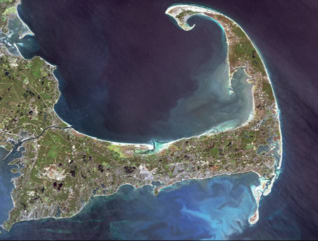
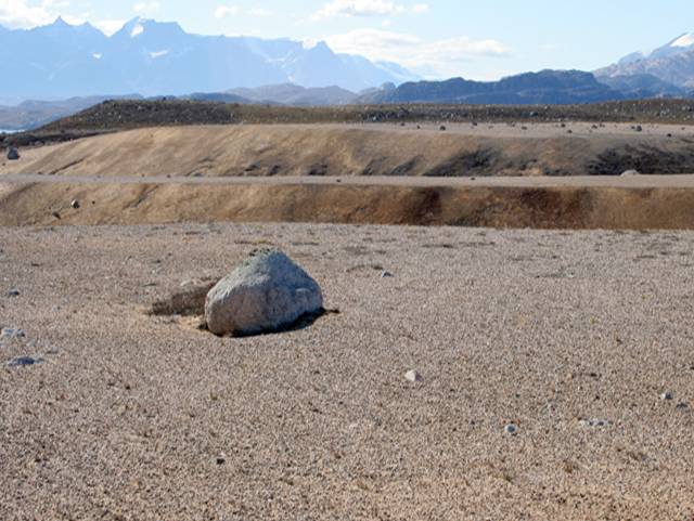
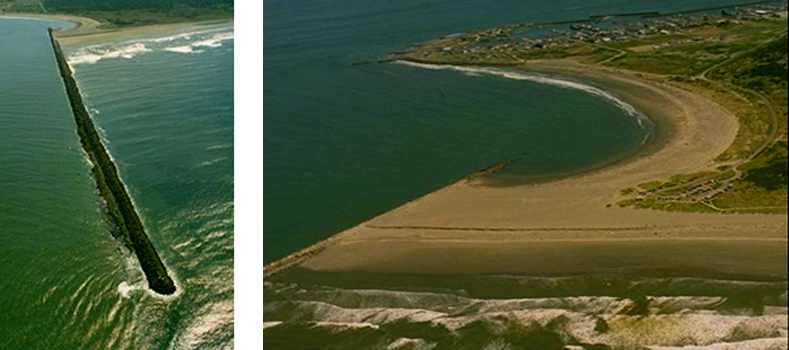
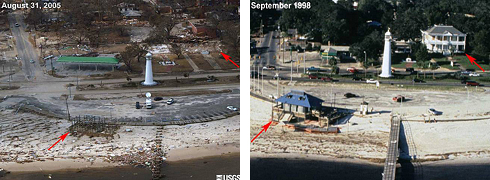
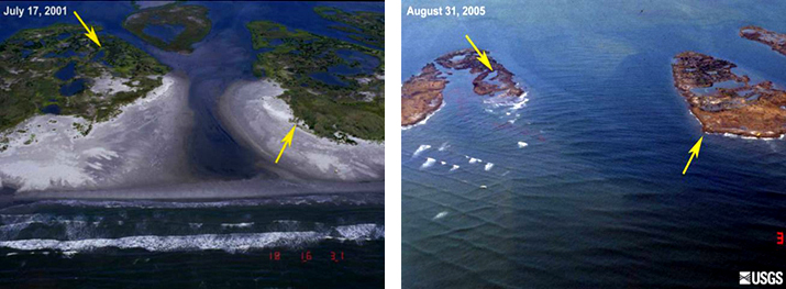
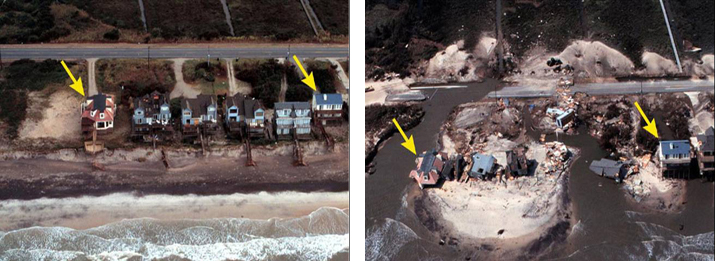
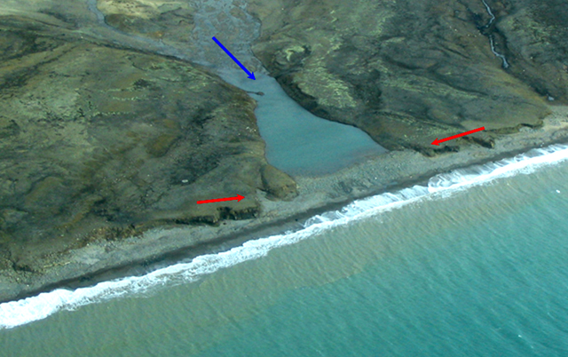
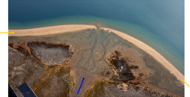
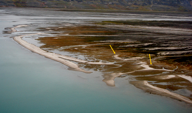
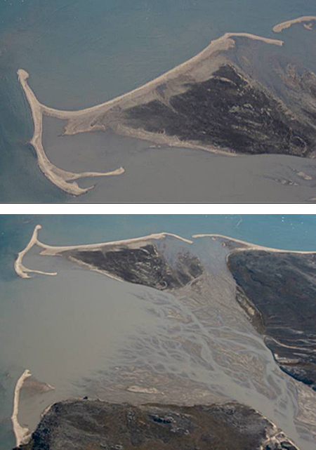
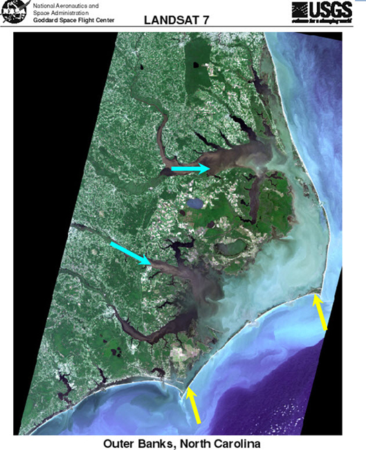
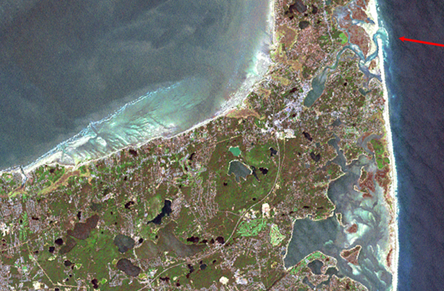
Image 1: Satellite image of Cape Cod National Seashore and surroundings. Coasting Down the Coast. Including a bit on sea-level change, some disasters, and some coastal processes, in some beautiful places. All pictures by R. Alley or taken from government Web sites as indicated. The image of Cape Cod National Seashore and surroundings is from Landsat 7.
Image 2: Raised delta, Milne Land, east Greenland. Rock in center foreground. Mountain peaks in background. Raised delta, Milne Land, east Greenland. About 12,000 years ago, a stream flowing to the left from beneath a glacier built the sandy fingers of this delta out into the sea. Then, the ice melted, allowing the land to rise, so the delta is now about 300 feet above sea level (sea is barely visible to the far left).
Image 3: A wall called a jetty built out from the coast in Washington, which has trapped sand on one side but caused erosion on the other side. Washington State Department of Ecology Shore photos--the state photographed their coasts, and makes these pictures available to the public--what a great idea! Two views of the Westport Jetty, Washington. Longshore drift from the right has built up sand to the right but caused erosion to the left of the barrier. Also notice in the left picture that waves are slowed by the shallower waters near the jetty.
Image 4: Hurricane Katrina aftermath. On right arrows point to antebellum and pier house. On left arrows point to where buildings used to be. http://coastal.er.usgs.gov/hurricanes/katrina/photo-comparisons/mainmiss... [5] Before-and-after photos of the aftermath of Hurricane Katrina, near Biloxi, Mississippi. The antebellum house (upper right) and pier house indicated by the red arrows were destroyed.
Image 5: A picture showing tree-covered islands before Hurricane Katrina, and the smaller, treeless islands left after the storm. http://coastal.er.usgs.gov/hurricanes/katrina/photo-comparisons/chandele... [6] Before-and-after photos of the impacts of Hurricane Katrina on the Chandeleur Islands, about 100 miles east of New Orleans. The sites marked by the yellow arrows can be identified in both photos.
Image 6: Hurricane Katrina aftermath. On left houses on Topsail Island, N. Carolina. On right, the same houses are destroyed. Before-and-after photos of the impacts of Hurricane Fran (1996) on Topsail Island, North Carolina. The house indicated by the left yellow arrow largely collapsed, that shown by the right yellow arrow lost its deck, and most of the other houses and much of the road were destroyed.
Image 7: A small stream draining into a Greenland fjord is dammed by sediment transported along the fjord shore. Evidence of longshore drift of sediment, Scoresby Sund, Greenland. The small stream valley flowing from the top (blue arrow) has been dammed by sediment transported along the coast (between the red arrows).
Image 8: Aerial view of delta, arrow points to sediment from stream that formed delta, two arrows point the beaches on each side. Sediment supplied from the stream (blue arrow) formed the delta. Waves have reworked the edge of the delta into the sandy beach (yellow arrows). Much of the area on the delta side of the beach is underwater at high tide, so this is a barrier beach. A helicopter skid is visible in the lowermost left corner.
Image 9: A braided river has wave-formed beaches near the sea; a recent storm moved some beaches well inland. Barrier beach, Mudder Bugt, Milne Land, east Greenland. Sand supplied from the right by the braided river has been reworked into the beaches shown. Storms have breached the beach on the right, washing sand into the lagoon behind and forming secondary beaches (yellow arrows).
Image 10: A delta formed by a braided river is surrounded by beaches and spits formed from the sand carried by the river. Mudder Bugt, Milne Land, east Greenland. The upper picture is a slightly turned close-up of the top part of the lower picture. Sand from the braided stream (lower right) is reworked by waves into the barrier beaches and spits seen, but the beaches are pierced by inlets.
Image 11: Satellite image of North Carolina, showing streams that deliver sand and barrier islands made from that sand. Satellite image of the Outer Banks of North Carolina, from USGS and NASA. Streams flowing from the left (two are indicated by blue arrows) have been flooded by sea-level rise in their lower reaches. Sand from the streams has been built into barrier islands (two shown by yellow arrows). Although the area covered by this picture is much bigger, the features are clearly almost identical to those shown in the previous pictures.
Image 12: Satellite image of Cape Cod. Arrow in upper right points to inlet to Nauset marsh piercing the great barrier beach. NASA [3] Closeup of part of Cape Cod. The great barrier beach on the right is pierced by the inlet to the Nauset marsh (red arrow).
Word Document of Unit 8 V-trips [7]
GeoClips
This week, we feature four GeoClips, all created while Dr. Alley was on vacation at the Cape in the summer of 2005. These four "home movies" provide a bit of insight into the origins of the Cape, and the forces that are continuously at work changing our coasts, shorelines, and seas. Shooting and editing credits go to Dr. Alley's wife, Cindy.
As before, we hope you enjoy these, and find them to be useful complements to the readings, class notes, and slide shows of Unit 8.
The Can
Human impacts on the land are easy to see. We have changed the oceans greatly, but the water covers our tracks. In "The Can," Dr. Alley briefly reflects on some issues of the oceans, as he watches one of the less-beautiful pieces of the Cape Cod National Seashore.
A beautiful, natural morning at Cape Cod. But if you turn to the sea, you can see that the evening revelers were there. I've been to the beaches of Greenland. I've been to the beaches of Antarctica. And everywhere I've been, the flotsam and jetsam of humanity are on the beach.
Oceanographers have traced the currents of the Pacific using shoes and rubber ducks that fell off of ships. More importantly, we've probably taken 90% of the big fish out of the ocean. We don't know what an ocean ecosystem should look like because it isn't natural anymore. We've changed the thing. We've put so much fertilizer into the ocean and places from runoff from farming and pollution and sewers that cause huge poison blooms that essentially kill the life when they rot. And taking care of the ocean is a big deal. And it's a deal we need.
The Marsh
Many of the ocean’s big fish, and other denizens of the deep, rely on salt marshes as nurseries and in other ways. But, we are losing salt marshes in many places, as sea-level rise forces the “outer beach” toward the shore, but humans don’t allow the inner side of the marsh to expand into our yards or parking lots. Obvious answers are not easily available, but Dr. Alley frames the question in this next short film clip as he paddles one of the family kayaks on the Nauset Marsh of the Cape Cod National Seashore.
Beautiful morning for a paddle. The tide's coming in, and a really happy professor is going out to see who's running around in the salt marsh, the Nossett Marsh in Eastham on Cape Cod. This is a place for birding. This is a place for shelling. These sand pipers are out getting breakfast.
Salt marshes are remarkably productive places. They are the nurseries of the fish and the shellfish. They're the nurseries of the ocean. They, too, need care.
The outer beach is coming in as the ocean rises. But the inner side is often hardened by humans and not allowed to move. And if we're not careful, we won't have these nurseries.
The Feet
Waves move immense amounts of sand, primarily up and down the beach, but also with a little motion along the beach and eventually off into deep water. In "The Feet," Dr. Alley gets cold feet on Coast Guard Beach, Cape Cod National Seashore, to show you moving sand.
Great Outer beach of Cape Cod, facing the Atlantic Ocean. Early morning. A lone figure leaving footprints on the sands of time. And you will see that, indeed, the waves move lots of sand. As the waves come in and out, and in and out, they keep moving sand ceaselessly, relentlessly. Notice the foot is on top of the sand when the wave comes in.
The foot is getting really cold, because that water is just straight out of the Arctic Ocean, practically. And now there's sand over the foot. And when the next wave comes, and the one after, you will see that indeed, the waves are moving sand in, out, in, out.
As they do so, they sort it. Little pieces are taken out to deep water and lost. Big pieces are not moved at all. And the in-between ones are swirling around the foot. And then another wave comes in, and then that one is really cold. And the hairy-legged sole here is soon going to be buried under the sand. And you can see how much sand is moved in just a couple of waves.
Meet Peat!
Cape Cod is a gift of the glaciers. The numerous kettle ponds left by the ice contribute to the biodiversity of the Cape, but are slowly filling in with sand, peat, and other things. Many of the ponds have already filled, and a walk along the rapidly eroding outer beach often reveals where the sea has cut into one of these filled ponds. In this next clip, Dr. Alley shows one such exposed, filled kettle pond, just below the old Coast Guard station in the Nauset region of the Cape Cod National Seashore.
We're on the outer beach at Cape Cod at Nauset, and we're looking at where the ocean has been cutting back a little bit of the bluffs to reveal what's behind. Now, most of the Cape is sand and gravel. It's outwash from the glaciers from the Ice Age. But what we see here is the filling of a lake. A block of ice fell off the glacier, was buried in sand and gravel, and then melted out to leave a little spot, a lake, which is filled with peat that you see here. The peat is the remains of dead plants. And if you look very carefully, you will see within the peat many of the dead plants.
On top here are grasses of the modern world, but they are not down in the material. Lakes die. They fill with this stuff. When you see a lake on the landscape, you should ask yourself, why is this here? Because something recent has happened to make the lake.
Video Lecture
The Unit 8 lecture features Dr. Richard Alley and is 51 minutes long.
Well, hello. It's a pleasure to be back and chatting with you. As you know, Sridhar and I have been working on this course together. And so, we're playing tag team. I won't actually throw him out of the ring. But we're going to do tag team. And so, now I get to chat with you for a while about some very interesting things. And I hope we have a good time with this.
As you've seen from Sridhar, we've been looking at a big story, a very interesting story, a story that goes a lot of ways. You've watched from Sridhar how the moving continents make big mountain ranges and how some of those mountain ranges explode and give you volcanoes, and how subduction works, and how obduction works, and what happens. You then saw that when you get these big mountain ranges sitting up there, that they have clouds over the top, and rain falls on them. And so, weathering happens and breaks down the rocks.
Then either glaciers come along or rivers come along, and they take the loose pieces of rocks and they head them down towards the ocean. You have seen that if you build a dam on one of those rivers, that you're going to end up trapping sediment behind the dam. And you'll get a big pile of sediment in there.
And if you don't build the dam, if you let the river do what it wants to do, eventually what you're going to find is that the river is headed down to the sea. And it's going to make a giant pile of mud such as the Mississippi Delta. And if you build your cities on top of the giant pile of mud, then they will sink into the mud. And you're going to have problems.
Now you can imagine that eventually we're going to have to close this loop. We don't just build infinite piles of mud that sit there forever. Somehow, that mud is going to make its way down into the deep sea where it can be taken in subduction zones, or it can be squashed in the giant collisions. And it can raise back up in the new mountains and start this over. And so, we're going to now try to close this loop. And we're going to close this loop by going and looking at some coasts for you.
So, let's switch over to some pictures for you. I happen to love coasts. I hope you do. They're very pretty places. They're very interesting to see. And as we're going to see, they are the extra piece that's going to get from the Mississippi Delta down into the deep ocean where eventually its subduction zone can grab something and take it back up.
Here we're going to start with a picture Cape Cod. You might possibly recognize this. It's a very nice coastal place. Cape Cod is going to be a lot of our story. Right now it is a beautiful place. It's a fun place. It is also a place that is disappearing, as we will see.
The magenta arrow sitting out here on the side is pointing at the outer beach. And the outer beach of Cape Cod is marching back. It is being eroded, slowing scratched away at a rate that's sort of that much a year. And if you had coastal property, that means well within your lifetime, it's gone.
Sediment from that, you can see if you look in this picture sort of the whitish stuff down under the sea, say down in here. This is sand that has been washed off of the great outer beach. It's being transported along. It is building the great island of Monomoy down at the bottom. It's also building the Province Lands up at the top. But then, some of it is ending up being dumped into deeper water either that way or that way. And so, eventually, what we're going to see is that Cape Cod is disappearing. It is a pile that is not sustainable. And, in thousands of years, it goes away.
Before it goes away, let's take some pretty picture looks at it because it is a beautiful place. We actually get to summer there sometimes. And we have kayaks. And so, we can go out kayaking and see what you can see. We also have daughters who like puns. So, one good tern does deserve another.
When we go to the Cape to visit, this is at Eastham. It's sort of about there. And when we go, this is the Salt Pond Visitor Center. And we like to stay right over here just out of the picture. And we take our kayaks, and we go out on the great Nauset Marsh which is sitting out here and goes for very long distances. And it's absolutely chock full of birds.
The wetlands are the productive, they're the nurseries of the ocean. They're the things that grow the fish. They grow all sorts of things. And they grow plenty of birds that can take care of them. You'll notice another bad pun, a fish that doesn't wash out may realize too late that he blew it. These are Great Blue Herons, of course, the big wading birds. There are lots of little wading birds around the marsh. Flocks of birds come through. You can just sit there in a kayak and watch for days and just keep seeing new things as they come along.
The marsh is a mixture of sand, a mixture of mud underneath, plants that are growing up, water that is sloshing in with the tides, and bringing in nutrients, and raising young things, and what have you. It's really a wonderful place.
The Cape is changing. This lighthouse, Nauset Light, almost fell into the sea because the outer beach was catching up with it. And they, just in time, hauled it back. They are hauling lights back all up and down the East Coast. Because wherever the lights are sitting on sand, the beach is heading towards them.
The Cape is there because of the glaciers. Sridhar talked to you about the glaciers. Most of the Cape is sand, and gravel, and mud. But it has little rocks like this one. This is Great Rock or Doane Rock. And it is 30 feet high, something like that. And it extends that far down below. The wind did not bring it. A glacier had to bring it there. It is just sitting there in the sand, the giant rock cliff, where the glaciers were. The glaciers made this big pile of sediment, and the ocean is slowly taking it apart. OK, a beautiful, beautiful place, a wonderful beach, a wonderful place to go visit.
Now, I'd like you remember that there's lots of different kinds of coasts. There's muddy coasts. There are rocky coasts. There are fjord coasts and so on. And so, I've got a picture here taken from space of Acadia, which is very, very different place up in Maine. And the yellow arrow that you can see pointing up there is pointing at a fjord. The US doesn't have many fjords on the East Coast. Although we have many on the left. And this sticks up into the heart of Acadia National Park.
Acadia National Park is renowned for the beautiful art that's been done of it. The Hudson River School painters love to go up and paint naturalizing sorts of things up there. The Rockefellers helped preserve this. I love the oil money going back into the public pot. There are these beautiful carriage roads that one can go ride your bicycles on if you ever get there.
Of course, the interest there is still the coast. It is a rocky coast now, not a sandy coast. The glaciers cleaned this off. They took the sand down to Cape Cod, and they left the rocky roots of the old mountain range sticking out where you can see them at Acadia.
Of course, they put the lighthouses on here. But this lighthouse is sitting on rock. And so, this one is actually not having to be moved back from the coast because the rock erodes a little slower than the sand does. And so, it's sitting there fairly happily at this point.
The glaciers carve these beautiful troughs through the mountains. And they're filled with lakes if you get inland and ocean if you get out to the coast. Here's a loon watching you right there. Wonderful, wonderful place.
Again, this is cleaned off by the glaciers. And so, the sand is down making Cape Cod. And you can see that hard rocks sticking out instead. And so, this would be granite sticking out there watching you very clearly right there.
You go down to the beach, there aren't many beaches. It's mostly rock. Where there are beaches they often are a little coarser. So, you'll see fairly large pieces down here. You would not go and sit quietly on the beach and play with the sand running through your fingers. These are rocks. And that's sort of one beach in that area. But there's not much.
And most of the beach at Acadia is more like this This is actually the bare roots of the mountain range, the granite hanging out where the waves are breaking against it and making great blow holes and spray flying when the storms come in. So, this is a very different sort of place.
You can see the tracks of the glaciers. You might remember that glaciers tend to streamline things as the ice goes over. And then, they pluck things loose from the end. And so, the glacier that went over this, and cleaned if off, and taking the sand down to Cape Cod, went the direction of the red arrow. So, you can see what the ice was doing as it came through.
OK. So, that is a little start of some of our coasts. They're beautiful places. They are mostly moving back at this point. Acadia is not. It's hard. It's sitting out there. But Cape Cod is moving back.
And so, let's talk a little bit about how coasts work, and what coasts do, why they tend to be moving back. And then, let's close that loop and show you how the mud of the Mississippi is eventually going to get down into the subduction zone where it can come back and make new volcanoes and come back over again.
To do this, we're going to start talking about waves. The main energy source for the coast now is not gravity. It's not glaciers or rivers going downhill. It's actually the wind-driven waves coming in.
So, let's imagine that you're way out in ocean somewhere, and you're in your boat, and that you have some waves going by. And so, let's do something like this. Here is a wave out in deep water. And you can tell which way is up because you have your boat sitting on top of it. There you go, wonderful boat. And let's say that the wind is blowing towards the shore. And so, the wave is moving this way. What happens when the wave gets to shallow water?
And the answer is that as you get a wave into shallower and shallower water, it starts to have friction with the bottom. It feels the bottom. And as it does that, whenever you run into friction, you sort of slow down. And so, as the wave moves in towards the shore, when it comes towards shallower and shallower water, what happens is the front slows down and the back catches up.
And so, if you were to check this wave later as it's gotten closer and closer to the shore, what you're going to find is it's doing something more like this. Here's a house over on the shore. So, you know you're getting there. And now, your boat is maybe in a more precarious position.
So, what happens is the front slows down, the back catches up, and they pile up. You can see this if you ever go down to the shore. You look out to sea, and you can see little waves coming in. But when they get close to shore, they make big breakers. Well, why? The front slowed, the back caught up. And if you take this long thing and you squeeze it, it gets high. And then eventually the top may fall over. And you get a breaking wave, and you can go surfing. So, at any rate, that's the first thing that one sees as the waves change that way.
Now, there's another important part that goes with this. Suppose instead of looking at the wave coming in and piling up, suppose that you had a helicopter, and you fly over the top in your helicopter. So, let's see if we can draw this. We're going to put the land over here. That's our beach. So, over here is land.
And you're sitting in your private helicopter, wop, wop, wopping over the top. And you're looking at the tops of the waves, or the crests of the waves as they come in. So, let's make waves in blue here.
And, typically, the wind will not be blowing exactly at the shore. It will sort of be coming in at an angle. And so, let's suppose that the top of a wave is sitting out here someplace, and the wind is blowing the top of that wave in. And so, if you had a whole line and surfers that were sitting on this particular wave, they'd be going in the direction of the arrow. They'd all be riding down the face of the wave going something like this. So, this is a top view of a surfer. And so, the surfers are all headed it in that way.
Now, what's going to happen? Remember the rule. Wave gets to shallow water, it slows down. And so, the water, as you might imagine, you're close to land up here, and you're far out down here. That's where the surfer is. OK, so, you're close to land at the top. You're far out down at the bottom. What happens when it's close in? The water is shallow. And when the water is shallow, the wave slows down.
So, on this end, when you look at the wave somewhat later, it's only moved a little. Now on this end, where it's far out, the water is deep. And where the water is deep, the wave is still going fast. So, when you look at this wave later, on this end the wave has moved a long distance. And if it moves a little bit on one end and a lot on the other end, what do you find? It's turned a little bit. And so, we have that.
And so, the wave it is now headed in. This side is still going slower. This side is going faster. If we look at this wave later, it keeps slowing down on the shallow end, and the other end catches up. And by the time it gets close to the land, it's coming in something like this. And the motion of the wave, now, is going almost towards the land, not quite, but almost straight in toward the land. And so, waves almost always turn until they're almost coming straight in.
And this is why you can always go down to the beach, and get on your surfboard, and ride the in and out. You never see anyone surfing down the coast. Because the wave is always coming in because it turns this way.
And so, what we find is that all the waves of the ocean turn. And the waves turn to come almost straight in, not quite though. And that's where this gets more interesting. The fast end never quite catches up because, as it catches up, it gets into shallower and shallower water. And it slows down itself.
And so, there's always a little bit of motion along the shore, not very much, but a little bit. And if you've ever gone down to the shore and sort of not paid too much attention. And you're just sort of riding the waves. And you come in, and you go out, and you come in, and you go out, and you come in, and you go out, and pretty soon the guard's chair is way back over that way. And so, you've got to go trucking across again. And so, there's always a little bit of motion along the shore.
So, you come almost right in. But there is a little bit of motion along the shore. Most of the motion is in and out. So, most in and out and a little bit along. So, that's an interesting thing that we can chat about.
I will show you a couple of pictures in a little bit when we switch over here. There are some seasonal effects in this, which is interesting. If you happen to go to the beach in the winter, you may not recognize it. Many beaches in the winter mostly wash away. The sand gets washed offshore a little bit. And then in the summer the sand gets brought inshore. And the reason is that the winter has bigger breaking waves. And the bigger the braking wave, the more in tends to take sediment offshore.
And this is an interesting thing. This one may not be the least bit obvious. But let's go to a new screen here. And let's see if we can do something like this. Here is now a beach face. Up here is the bathhouse where you go changing. And we have to have blue so that we can do water. And so, we have some water coming in here.
And now let's ask something. What happens if there's a giant breaking wave? OK. There's a giant breaking wave. You've got your surfer on this, crazy people out there. And what happens? The water is coming in through the air. It's not surging up the beach face, it's coming in through the air.
What's it going to do? Well, you know what it's going to do. It's going to turn over. And it's going to crash down. And there's going to be a giant BFFFT! And then the water is going to go out along the beach. Well, what does that mean? If the water comes in through the air, it's not bringing much sand in. When it goes out along the beach, it takes some sand out.
And so, at the end of a giant winter storm, the sand-- let's see if we can make some other interesting color for sand-- at the end of the giant winter storm, some of the sand has been transported out here. It's sitting down in there. And some of it may have gone off the edge into deep water.
In the summer when it's nice and quiet, and people are out there bobbing around with their kids and their little boogie boards, the waves are not so big and crashing. The waves come in more like this. And they'll actually bring some of this sand back on. But the really deep sand they won't. And so, the observation is very often in the winter, beaches will be moved offshore. In the summer, they'll be moved back onshore towards your beach. But some of it will get out to deep water and fall off.
So, just a couple of notes here is that big waves come in through the air. And if you're surfing on that big wave when it comes in through the air, it might be very interesting. And they go out along the surface. And because of that, because they're coming in, breaking through the air, they're going out along the surface, they tend to move sand. A little more sand goes out than comes in. Some comes in. If you stand on a beach facing that big wave, you'll get sand in your teeth. Don't worry. But a little more goes out than comes in. So, more sand out than in with big waves.
But with the little waves, it turns out, they come in just a little faster than they go out. They bring a little more in than they take out. And so, over time, they will build it back up. And so, the big waves coming in through the air out along the surface move more out than they bring in. The little waves bring in more than they take out, just a little bit. If you watch a wave as it surges up that beach towards your feet on a nice day, it'll come in just a little faster than it goes out. And as it comes in a little faster, it will bring in a little more than it takes out.
So, the little waves bring a little more sand than they leave with. And they build the beach back in the summer. So, they take a little more in than they take out. They build beaches. But they can't reach really deep.
Waves cannot go two miles down in the ocean, and grab some sand, and bring it up. So, if those big waves took it out to deep water, it's lost. It's gone over the edge. It's headed down to the deep water, headed down to the trench if there's a trench there. It's headed for the subduction zone. It's headed back to the volcanoes. And so, waves can't reach too deep. They can't reach to the bottom of the ocean. And so, when you get sand out to really deep places, it's lost. You need a subduction zone to bring it back. And so, eventually we're going to close this balance, and we're going to get somewhere.
When we think about these waves coming in, they bring it in on each wave. They take it out on each wave with the sand. They bring a little more in in the summer. They take a little more out in the winter. They lose a little bit more down. But you have this motion along the shore going on because the waves don't come quite straight in. So, there's always this little bit of in and out and drifting along the shore.
And so, we call that drifting along the shore a very technical name. We call it longshore drift. And so, the motion along the shore is longshore drift. Somebody lost the A sometime back in history. So, it is a longshore drift. And you're just drifting along the shore.
What you can think of now, the drift of sand along the shore is a little bit like the sand moving down a river. And so, now you can think of the beach as being a river of sand. So, let's call the beach a river of sand. It's very often used in geology. It gets sand where? From the Mississippi Delta, from lots of places that it can pick up sediment. If it's eroding a little bit, it's getting that sediment. It takes it along the shore, and then, eventually, in these big storms, or when it comes to a really deep spot, it loses that sand down into deep water.
And so, it's going to lose sand from somewhere. It has to pick up sand from somewhere. And so, you have to have a balance. Just like a river is getting sediment from mass wasting delivering it, it's losing the sediment down to the delta, or down to the reservoir, down to the ocean. The beach has to be getting sediment from somewhere. It has to be losing sediment to somewhere else.
And so, the beach loses sediment to deep water. Lose sand to deep water, we've seen that already. And it has to get the sand from somewhere. And it has various choices. It's either delivered by the rivers or the waves are going to take apart what ever is behind them to get that sand. So, it gets sand somewhere.
And so, we're going to look at some pictures here now to show you where you get the sand from. We'll come back. So, let's switch over to a pretty picture time. We're back to Cape Cod. And now, we're going to try to talk a little bit about how beaches work. I'm going to show you a bunch of pictures of different beaches, and what they've done, and how they behave. And we'll see if we end up somewhere.
So, this is a weird beach. You don't have to worry too much about this one. This is a very interesting beach. We are actually in Greenland at this point. And you may possibly remember when Sridhar was telling you about glaciers, that glaciers are very big, and they can be very thick, and they can be very heavy. And we know that the land down underneath, down in the upper mantle is soft.
And so, you put a big weight on the land, and it sinks. And you take that weight off, and the land bobs up. But it's slow. It's like sitting on a waterbed that's full of molasses. It doesn't sink immediately. And so, it's slow.
So, what happens is in places where glaciers melt the land is push down, and the ocean comes in. And you get beaches. And then the land raises up. And those beaches get raised out of the ocean. And so, here way over in the corner you'll just barely see the ocean sitting way over there. And here is the top of the old beach that has now been raised 200 and some feet out of the ocean as the land popped up.
And so, you can actually see this particularly one was sort of a delta/beach combination. And you can see where the sand coming down from the rivers was deposited. And it was growing out in the ocean. And then the land popped up. And here's this beach sitting up there in the middle of nowhere on the edge of Greenland. So, that's sort of cool. I don't know what you'd do with that. But it's cool.
This may be a little more interesting. These are pictures. The state of Washington has actually put pictures of their whole coast on the web. And you can find the website here. And if you want to see a particular cool place along the coast of Washington, they've got pictures of it. And that's all right.
And so, this is a place, the Westport jetty. They built this big, big wall that's sticking out into the ocean here. And there's a number of things that we can learn from looking at the Westport jetty. One of them is this business about how waves behave. You'll remember that when a wave hits friction, when it hits shallow water, it slows down and that in deep water the waves are still going faster.
So, suppose you're a wave. And you come in here, and here comes a wave coming in. And so, there is the top of the wave I've drawn in yellow. And the wave is moving in the direction of the arrow that we're showing.
OK, so what's going to happen to this wave when it hits the jetty? Well it slows down on the shallow end by the jetty. And so, if we watch the wave, you'll see the top of it sort of there. And then you'll see that it starts sort of bending around. It's moving fast out here in deep water. And it's moving slow right there in next to the jetty.
And so, later we look at the thing, and you can see that it's bent a whole lot. And so, it's wrapping around. And you look way in there, and you can see actually wave tops that have bent all the way the other way. They're being held slow against the jetty. They're moving faster elsewhere. And they're trying to turn to come in towards the shore. And so, the waves are always trying to turn to come towards the shore. And we see that happening with the jetty.
There's some other things, though, that happened in this picture. You'll remember that the waves don't quite come straight in. They move sand along a little bit. And so, the waves have just a little bit of motion which is tending to cause the sand to go this way. And so, the net is a little bit of sand moving along this way headed that way.
Now, what happens on a river if you have a dam, and you slow down the water. The river is bringing in sand, and it dumps it right front of the dam, and it fills in the reservoir. What happens if you build a dam on a river of sand that is the beach? Well, it does the same thing. It fills in with sand here. The dam of the jetty is trapping sand. You see it in that picture. You see it in the other picture that we have here. And so, this is the sand that has been trapped as it drifts along, and it comes up to this big dam which is the jetty.
What happens then is that the sand is blocked there. And so, clean water gets around. And that water promptly starts picking up sand. And so, you end up with places like this that are eroding because the clean water passing your dam is going to pick up more sand again. And so, you end up with a deposit on one side and an erosion on the other side out in here.
And so, whenever you put a dam like this up, it makes a big difference to a whole lot of things. If you wanted to save your house, and you put up a dam like this, you'd say, wow, I'm happy. And then your neighbor's house would get eroded. And the neighbor would be very unhappy. And so, whenever you tweak something like this, it matters.
There are other ways that sand moved. It's not always in the winter. It's not always very simple. 2005, Hurricane Katrina comes in. It was not a nice hurricane. It was not nice to New Orleans. It was not nice to very big pieces of the coast. Here are a couple of pictures.
Picture in the upper left here is a September 1998 picture of the coast near Biloxi, Mississippi. And if you notice the sort of building that the red arrow is pointing to with the blue roof over there-- somewhere about there there's a nice blue roof-- if you come back and look at the picture after the hurricane, you'll notice that it's different.
And you'll notice a number of other things. There's a very, very beautiful antebellum mansion in the before picture, that white building. And you'll notice that it isn't actually there in the after picture. Terrible, terrible things that can happen.
Pieces of that are now part of the beach. Some of them get washed inland. Some of them are left there. But some of them are down on the beach. And so, if you compare the look of the beach right here before, and you compare the look of the beach afterwards, you can see that nature really is, when the waves come in, they will get things. They will make a beach. They will erode what's behind them if they can.
These are two more. This is a natural setting now rather than a human setting. These are the same places. It may not be immediately evident. The arrows are pointing to things that are matched. In the far upper left of the before picture over here there's a little lake that is outlined right there that the yellow arrow it was pointing to. And that same lake can still be identified in the after picture.
And I hope it is fairly evident that there is more stuff in the before picture, more plants, more sand, and so on, that are available than there is in the after picture. If you look, you'll see some of the sand in the after picture is down there. It's been moved around. It's been eroded. It's been transporting away. So, it's very clear that when those big waves come in, they grab pieces of the beach, and they take them away.
This is not the same hurricane. There are lots of hurricanes. There are lots of coasts. These are before and after pictures for Hurricane Fran in 1996 on the Outer Banks of North Carolina. There's a yellow arrow in the before picture pointing to somebody's really fancy orange beach house up there. Boy, I bet they liked that thing. And then after they eventually had to tear the thing down because this new stream showed up. The beach was torn apart, and it undermined the house, and it started to fall in.
You'll notice that somebody had a really nice beach house right here in the before picture. And that's it in the after picture. It went away. It was not very nice. And so, you can see that there's a lot of changes when big waves come in and they attack things.
This is evidence of longshore drift in a very much nicer place. You don't have to worry about as much. We're back in Greenland now. And what you'll notice is there's ocean that's sitting out here. The waves are moving along this shore a little bit. Boy, that's not very well written. But here's ocean.
Here, this is actually Scoresby Sund in East Greenland. And what you'll notice is that the sediment has been transported across the mouth of a little stream. And so, this sediment bar has been built up here by sediment being moved along. The sediment is headed for somewhere. It's headed for somewhere deep to fall off into the deep water. But on the way it may pause temporarily and give you interesting things like this.
These are some more pictures in Greenland. You have streams that are bringing sediment down from the glaciers and taking them out to the ocean. So here is a big stream. It's carrying lots of mud and sand. And so, it gets all these bars out there. And you can see the muddiness of the water.
And when it meets the ocean, the waves start to move the sand. And the waves make bars-- outer beaches, if you would. And so, you get these beautiful barrier beaches. All of these things have geologic names that you can learn if you get really excited by this, little tidal inlets and all sorts of other things going on.
And so, you see some very interesting things. And it's obvious that the sand is being affected by the waves where the ocean meets the land and the rivers. You get interesting things going on.
This is the same thing except very much bigger. And so, now we're looking down on the Outer Banks of North Carolina. And you have rivers that are coming out like this. And they're carrying sediment. And the sediment gets down to the sea. And the sea stars banging against it. And it builds these wonderful barrier islands that we know along the coast of North Carolina.
And then behind the coast you get the great embayments that people go sailing in, and they have a good time in, and so on. But these are places that when a giant hurricane shows up, it just goes right over the top. That's very low. And it makes a huge difference to what's behind us. And so, when you look at something like this going on in Greenland, you basically have the same thing on a bigger scale going on on the coast of the US.
OK. So, let us go back. And we're now going to try to draw a few more things for you. And then we'll see if we can get out of here without getting too bored with beaches.
So, what we see is that the beach has a balance. It's getting sediment, it's losing sediment. If it loses too much in the deep water, what's going to happen? Your beach gets skinny. If the beach is skinny, what happens? The waves go over the beach, and they take apart whatever is behind it. They take apart houses. They take apart roads. They take apart natural deposits, whatever is there.
If Acadia, if it's really hard rock, they have trouble taking it apart. And you have no beach. If it's soft stuff, they take it apart and they rebuild the beach. And so, what we have to do then is if the beach gets too little sand, if there's too little sand being supplied to the beach, what you just saw from the hurricanes and other things, if there is a little sand supplied to the beach, then the beach will be narrow. And if the beach is narrow, the waves will come right across the beach, and they will tear apart whatever is behind it.
So, the waves will cross the page, and they will erode what's behind it to get sand. And that sand may start out as your car. It may start out as your house. It may start out as a natural deposit from a glacier. It may start out as granite in Acadia, whatever. The waves don't really care. They're coming across the beach, and they're going to beat up whatever is behind it. And they're going to make enough sand so that the waves can't get across the beach anymore.
And so, we have a balance now. You're supplying sand. You're transporting it. You're losing it into deep water. And you have to ask what tweaks to balance. And we humans keep tweaking the balance. For example, we build dams on rivers.
So, suppose you dam a river. What happens? People did this in Olympic National Park on the Elwha. They make a little power out of the Elwha. It's a beautiful river. It sort of cuts off all the salmon that used to migrate up there. It also cut off the sediment that the river was taking down to the coast.
Well, the next thing that happened is the waves just took the coast away. They eroded right across the beach. And the Native Americans that used to shell fish on the beach there can't do it anymore. The Corps of Engineers is spending a lot of money to shore up the harbor next door because there isn't sediment coming in the longshore drift because the sediment is trapped up in the dams.
So, if you dam a river, you stop the sediment supply to the beach. What does that do? It means that the beach will lose sand in the deep water. It won't get as much supplied. And it will narrow. And then the waves come across, and they take apart your house.
So, one of the things that we humans do that matters is tweaking this, if you would. There are some natural things that feed into this as well. And they're probably worth pointing to as well. If we switch back, for a moment, to the pictures, we're going to try to go back and see a particular slide here if I can make this work. And so, we'll view the slide.
This is along North Carolina. And what one can notice in something like this is that many of the East Coast rivers are flooded way inland. When the sea level rose at the end of the ice age, it flooded river valleys. And so, all up and down the East Coast we have bays. The Susquehanna flows into the Chesapeake Bay. Why is a bay there? The sea level rose at the end of the ice age.
And so, if you now switch back over here for a minute, we will see if we can draw something like this. Imagine, if you would, you're looking down, and you have a river. And the river is running out to the sea. And so here comes some sort of a river, and it comes out to the sea. You're looking on this from your helicopter. So, out here is the sea. And over here is the river. And you know that if you look down on the river valleys, that the river is sort of lower. And around it you'll have hills of some sort or another. And so, let's draw in some hilltops like this. And then something like that.
Now what happens when sea level rises? And when sea level rises, the sea will flood up the river valley. And so, you'll have the sea moving inland, and it will flood up the river valley. And then you have a big bay. And so, the Chesapeake Bay, or the Delaware Bay, or all those bays along the coast of North Carolina are old flooded river valleys.
Well, now what happens? The river brings mud down to the sea. Where is the mud going? Is it getting out to the beach out here? And the answer is no. The mud can't get to the beach out there. And the mud can't get to the beach out there because it's piling up here.
And so, because of the end of the ice age, there is less sediment reaching US beaches than there otherwise would. Because the sediment is trapped way up at the head of the embayments filling them in trying to build out to the beach where it can get there.
And so, if we write this down rather slowly, the ice age ended. And when the ice age ended, sea level rose because the ice melted. Remember, right under the ice it's pushed down. And then it bobs up. But most of the rest of the world was not pushed down by the ice. And so, the water coming from the melting ice sheets fills up the ocean. And it gets higher. So, sea level rose.
And as sea level rose, it flooded the rivers, and it made bays. And so, we have all these beautiful bays up and down the East Coast of the US because the ice age ended. And the rivers are now filling the bays with sediments. Rivers filled the bay with mud, sediment, whatever. We'll write mud. It goes faster.
But because they are filling the bay with the mud, that mud is not getting out to the beach. The sand is not getting out to the beach where it can nourish it. And so, the beach gets eroded. It gets narrow. And the waves take apart what's behind it to get their mud. So, the rivers filled way with mud. It doesn't reach the far out coast. It doesn't reach the beach-- reach the beach-- OK, reach beach. And so, we then see erosion going on at the beaches because they're not being supplied the sediment that they should be. And so, both human activities in damming rivers and natural activities in flooding things at the end of the ice age have contributed to this problem.
Now there's some others floating around. Cape Cod, remember, is a pile that was made by the glaciers. It happens to be a pile that was made by the glaciers in a place that there aren't many big rivers delivering sediment to the coast. And so, you go and look at something like Cape Cod, and it is a pile from the glacier. And it is a pile from the glacier that happened to be made in a place that rivers don't supply much sediment. So, there's nothing replacing the stuff that goes into deep water. OK, so there's no big rivers to supply sand.
And you know if you have a bank account, and you take the money out, but you never put any in, eventually it gets empty. And so, as Cape Cod loses sand to deep water, it is not getting a new supply of sand from the big rivers. And so, Cape Cod eventually, over thousands of years, is a goner. It's going to go away. And so eventually you lose the Cape.
You don't have to run screaming and panicking. It will take a long time for that to happen. Naturally, then, another ice age is supposed to come. The glaciers build the thing back up. And it would be happy again. Whether that happens with human activity will matter.
Another thing that's worth noting is that, in many places, we humans are making things a little worse by pumping water, and oil, and gas out of the ground. And when you pump water, and oil, and gas out of the ground, the surface settles a little bit. And if you're pumping them out from under New Orleans, and the surface settles, now you have a problem because then the sea comes in when you have a hurricane. And then you're very unhappy about this.
And so, pumping oil, and gas, and water out from under the coasts makes them sink. From under the beaches. And we do this in some places. We're getting smarter about this. But we're not real smart yet.
And so, if you're interested in this, and so, the net of all of this, the net of our damming, the net of nature, and the net of sea level rising, and sea level is rising. We will talk about the whys a little bit later in the semester. But sea level actually is rising. Mountain glaciers are melting. The ocean is warming and expanding. And so, sea level is rising.
And the net of all of this is that probably 3/4 of the US coast is moving inland. We're losing land on 3/4 of the coast. And about 1/4 is either holding its own like at Acadia, or maybe advancing a little bit in a few places. And so, the net of all of these different things is sort of 3/4 of the coast is losing. It's coming back. The coastline is being lost at this point.
That's a huge thing because we live, a lot of us, along coasts. We vacation along coasts. We love coasts. Coasts are really expensive, and they're wonderful. And everyone likes to go down to them. And they're busily being gnawed away. And that's not a good thing.
Now people try a lot of things to keep the coast from being gnawed away. They go down, and they dredge sand out of deep water. You spend immense amounts of money. And you pull the sand, and you put it back on the beach. And the next storm takes it back to deep water. And then you go it again. And so, people are trying this.
So, what do you do? OK, one thing is beach nourishment. Go get sand out of deep water and pump it back up on land. That's expensive. And it takes a lot of energy. And it doesn't last very long. And put it on the beach.
People are talking about taking out dams in places. We haven't done much of that yet. But they are actually talking about taking out dams and letting the sediment go back down. We actually bought the Elwha dams in Olympic National Park. And we were going to take them out. But now they're paying money from the hydroelectric power into the government coffers. And we're not taking them out right now. So, people are looking at that.
Some people try to change the shoreline. Remember when we saw that big jetty out along the coast of Washington that it entraps sand. And so, you'll see many people who actually have tried somehow to change the shoreline.
Suppose we get back in our helicopter, and we look down. And over here we have land. And out over here we have ocean. And in the ocean we have some sort of a longshore drift that is running this way.
And so, suppose you are sitting down here, and you say oh, my goodness. I've got this wonderful beach house here. And I love my beach house so much. And I want to save my beach house from being eroded. So, I go, and I build a giant jetty that sticks out into the water. They're also called groynes. So you're going to build a dam, or a jetty, or a groyne. They're all the same thing basically. But you may see all those different names somewhere in your life.
All right, so what's going to happen? You're going to be fairly happy for a little while. Because what's going happen is as the sand comes drifting along the shore on the beach, and it gets to where you are, it will start to pile up. And that will make you happy because now you've got a nice beach, and you're not worried about it. OK.
But the question is suppose you have a neighbor. And your neighbor also has a beach house. And the clean water goes around. So, this goes around without any sand. And what does it do? It starts picking up sand. And so, it starts eroding down here. And your neighbor's house falls in. And then your neighbor sues you.
So, when you do this, you trap sand here. But often-- not always-- but you often end up with erosion on the other side as the clean water gets around the jetty or the dam. And so, you may get erosion here. And if it erodes on this side, then your neighbor's going to sue you. And then it's going to be a real mess.
Geologists have looked at this. And they say, you can do things. You can build things, you can pump things, you can take out dams. In the long term they've said, you know, maybe we should just move back from the beach in some places. Maybe the great outer beach at Cape Cod really is a good national park. And if we just stay off of the beach and let nature play with it, and we go down and enjoy it, if we keep some of these beaches in the national park system, we'll be happier.
Want another look?
Check out the Unit 8 Presentation [8] used in the online lecture.
Optional Enrichment Article
Wishing for Water - When Salt and Fresh Mix
Groundwater pumping can also cause saltwater intrusion. Fresh water has lower density than salt water, and so floats on salt water in the same way that an iceberg floats on water. (Salt and fresh water will mix, but if the fresh water is renewed by rainfall, the mixed waters will be forced out through the beach to the ocean, and there will continue to be nearly pure fresh water sitting on salty ocean water.) If the water table is lowered by pumping fresh water for human use, the interface between salt and fresh water will rise in the same way that the bottom of an iceberg or a mountain range rises if the top is eroded. The difference in density between salt and fresh water is small; an iceberg floating in the ocean has 9/10 of its thickness below the surface, but the fresh groundwater lens of Cape Cod floating on ocean water has 39/40 below sea level. So if enough water is pumped out of the well to lower the water table 1 m, the salt water will have risen 39 m! If the freshwater table is lowered to sea level, the salt water will rise to sea level, and there will be no fresh water left at that point. Many wells on the very low land of Cape Cod were drilled below sea level into fresh water, but are starting to pump up salt water, causing large problems.
.gif)
Before groundwater pumping, a lens of fresh groundwater extended above and below sea level, floating on deeper salt water. But if enough groundwater is pumped out to lower the water table to sea level, then salt water will rise to sea level, and the well will be pumping salt water.
A Rocking Review
Yellow Submarine
The Beatles' Yellow Submarine surely must be very high on any list of songs likely to get stuck in your brain and play over and over and over and... But, watching our beaches, with perhaps three-fourths of the US coastline retreating inland in response to rising sea level and other changes, maybe a really "sticky" song is what we need down by the shore! Anyway, we hope you enjoy this parody, which really does review a lot of the key points that are likely to show up on the RockOn quiz. "We need more sand or the beach will wash away..."
CARL PILLOT: One.
[BANG]
Two.
[BANG]
A one, two, three.
- RICHARD ALLEY: (SINGING) Near the town where we were born, there's an ocean, not far away. And you know when rocks get worn, they make sand for beaches where we play. Suppose you ride down onto the shore, just to while away your summer day. Splash no beach there anymore.
Could that happen here? What would you say? You'd say, we need more sand, or the beach will wash away. The beach will wash away. The beach will wash away. It guards the land, and the beach can wash away. The beach can wash away. The beach can wash away.
All the waves move sand about, mostly in and then right back out. Some will drift along the shore. Crashing winter breakers take out more. If sand falls too deep, it's gone down into the subduction zone. And it may take 10 million years, eruptions, weathering till new sand appears.
So, we need more sand, or the beach will wash away. The beach will wash away. The beach will wash away. It guards the land, and the beach can wash away. Beach can wash away. Beach can wash away.
If we melt glaciers into mud, sand will disappear beneath the flood. Dams on rivers will impede lots of new sand beaches need. You will not have too much luck making beaches with your rubber duck. Chunks of houses might suffice. But for volleyball, that isn't nice.
So, we need more sand, or the beach will wash away. The beach will wash away. The beach will wash away. It guards the land, and the beach can wash away. The beach can wash away. The beach can wash away.
If beaches fade beneath the sea, you might need a yellow submarine.
[LAUGHTER]
[MUSIC PLAYING]
Wrap Up
Review the Unit 8 Introduction
You have reached the end of Unit 8! Double-check the list of requirements on the Unit 8 Introduction page and the Course Calendar to make sure you have completed all of the activities listed there.
Unit 8 Overview
Review of the main topics and ideas you encountered in Unit 8.
Getting the Most from the Coast: Cape Cod, Acadia, and Friends
- There are many coast “types” (beach, reef, mud flat, cliff, delta, etc.; we’ll especially focus on beaches).
- Waves move LOTS of sand, mostly in, out, in, out…, which sorts by size to create sandy beaches.
- Waves move a little extra sand out during winter storms (breaking waves come in through air without sand, go out along surface with sand).
- Move a little extra in summers (surge up the beach a bit faster, moves a bit more than return flow).
The Coast Is Friendly--the Ocean Waves
- Waves go slower in shallower water;
- First part of the wave slows as it nears coast and waits for rest of wave to catch up, so piles up to break, and turns to come almost straight in;
- But still has a slight angle, driving longshore drift of sand and water;
- Eventually, some sand is lost to deep water below the reach of waves;
- Beach needs sediment supply to balance this loss.
The Coast Is Friendly--Buoy Meets Gull
- New beach sand by longshore drift from river-fed deltas;
- Or by erosion of coast behind beach;
- Lose longshore drift from river-fed deltas by
- dams on rivers (Elwha dams in Olympic caused beach loss);
- “dams” along the coast (jetties or groins that stick out, block drift to trap sand, let clean water pass to erode beyond);
- past sea-level rise, flooded river valleys so sediment fills bays and doesn’t reach outer beaches (e.g., Chesapeake);
- past deposition (especially by glaciers) forming coastal land (e.g., Cape Cod) without big rivers to supply sand.
But many coastal residents are crabby
- Most U.S. coasts retreating (about 75%);
- from past sea-level rise and glaciation, dams and coastal modifications (see the previous point, "The Coast Is Friendly--Buoy Meets Gull");
- from sea-level rise now (from warming expanding water and melting ice, plus groundwater mining, with worries about the future of huge ice sheets);
- from pumping of groundwater, oil and gas allowing compaction and sinking;
- Regions pushed down by ice-age ice may be rising; those bulged up before ice-age ice sink faster; mountain-building also matters.
Reminder - Continue to work on Exercise #4. Consult the Course Calendar for specific due dates.
Supplemental Materials
Following are some supplementary materials for Unit 8. While you are not required to review these, you may find them interesting and possibly even helpful in preparing for the quiz!
- Website: Cape Cod National Seashore [9]
- Website: Acadia National Park [10]
Comments or Questions?
Please feel free to send an email to ALL of the teachers and TA's through Canvas conversations with any questions. Failure to email ALL teachers and TA's may result in a delayed or missed response. See "How to send email in GEOSC 10 [11]" for instructions